Almere
| Almere | |||
|---|---|---|---|
 |
|||
|
|||
 |
|||
| Coordinates: | |||
| Country | |||
| Province | |||
| Government | |||
| - Mayor | Annemarie Jorritsma (VVD) | ||
| Area | |||
| - Total | 248.77 km2 (96.1 sq mi) | ||
| - Land | 130.47 km2 (50.4 sq mi) | ||
| - Water | 118.29 km2 (45.7 sq mi) | ||
| Population (January 2009) | |||
| - Total | 186,011 | ||
| - Density | 1,369/km2 (3,545.7/sq mi) | ||
| Time zone | CET (UTC+1) | ||
| - Summer (DST) | CEST (UTC+2) | ||
| Website | www.almere.nl | ||
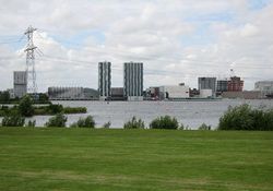
Almere () is a city and municipality in the province of Flevoland, the Netherlands, bordering Lelystad and Zeewolde. The municipality of Almere comprises the districts Almere Stad, Almere Haven, Almere Buiten, Almere Hout, Almere Poort (under construction) and Almere Pampus (design phase).
Almere is the youngest city in the Netherlands: the first house was finished in 1976, and Almere became a municipality in 1984. It is the largest municipality in Flevoland with 184,405 citizens (7 July 2008)[1], and the 8th largest in the Netherlands[2]. In October 2007, the city council of Almere made agreements with the government to expand the city to 350,000 inhabitants by 2030[3].
Contents |
History
The original plans for the IJsselmeerpolders saw the land being used for agriculture. However, after World War II housing was needed for the rapidly growing population of Amsterdam and two towns were planned in the polders Oostelijk Flevoland and Zuidelijk Flevoland. The town in Oostelijk Flevoland became Lelystad. The town in Zuidelijk Flevoland was still called Zuidweststad (English: South West City) on the first sketches, but in the 1970s it became called Almere, named after the early medieval name of the Zuiderzee. The first house in Almere was finished in 1976. At that time the town was still controlled by the Openbaar Lichaam Zuidelijke IJsselmeerpolders (Z.IJ.P.), with a Landdrost. In 1984 Almere became an official municipality. Originally, Almere was envisioned as a town with multiple centres. This idea was later abandoned in favor of allowing neighbourhoods like Tussen de Vaarten to be built. There is also a difference between the way houses are built in the oldest and the newest parts of the city. The housing plan in Almere in the 1970s was basic functionality and a levelling of social status. However, starting in the 1990s more exclusive homes with striking designs were built (e.g., in the Regenboogbuurt).
Governance
Local executive
Former minister Annemarie Jorritsma-Lebbink (VVD) has been the mayor of Almere since 16 August 2003. On 20 May 2010 the new council was inaugurated. The populist Party for Freedom had won the most seats in the local elections, which was both national and international news due to the controversial statements of its leader Geert Wilders. Even though the largest party they didn't take part in the local administration.
- Adri Duivesteijn (PvdA)
- Ineke Smidt (PvdA)
- Arno Visser (VVD)
- Ben Scholten (VVD)
- René Peeters (D66)
- Berdien Steunenberg (CDA/CU)
List of mayors:
- 1984 - 1986 Han Lammers (PvdA)
- 1986 - 1993 Cees de Cloe (PvdA)
- 1993 - 1994 Cees Roozemond (PvdA, supervisor)
- 1994 - 1998 Ralph Pans (PvdA)
- 1998 - 2003 Hans Ouwerkerk (PvdA)
- 2003 - 2003 Jaap van der Doef (PvdA, supervisor)
- 2003–present Annemarie Jorritsma-Lebbink (VVD)
City council
The first local council was installed on 2 January 1984 in the presence of the then minister of the Interior Koos Rietkerk. The council elections took place on 21 September 1983. Prior to 1984 Almere had an Adviesraad, which was chosen every 2 years (1978–1980, 1980–1982, 1982–1984). This Adviesraad was made up of different political parties similar to a local council. On 11 March 1977 the first adviescommissie was elected. It consisted of 5 people that were chosen on personal title. Since 1998, the council of Almere has a total of 39 members.
| Party | 1984 | 1986 | 1990 | 1994 | 1998 | 2002 | 2006 | 2010 | |
|---|---|---|---|---|---|---|---|---|---|
| PVV | - | - | - | - | - | - | - | 9 | |
| PvdA | 10 | 14 | 9 | 6 | 9 | 7 | 12 | 8 | |
| VVD | 5 | 5 | 7 | 10 | 12 | 8 | 7 | 7 | |
| Leefbaar Almere | - | - | - | - | - | 9 | 4 | 3 | |
| SP | - | - | - | - | - | - | 4 | 2 | |
| GroenLinks | 2 | 1 | 3 | 4 | 4 | 4 | 3 | 3 | |
| CDA | 2 | 3 | 4 | 3 | 3 | 4 | 3 | 2 | |
| Almere Partij | - | 1 | 2 | 2 | 3 | 2 | 2 | - | |
| ChristenUnie | - | - | - | - | 1 | 1 | 2 | 1 | |
| D66 | 1 | 2 | 7 | 10 | 5 | 2 | 1 | 3 | |
| Trots op Nederland | - | - | - | - | - | - | - | 1 | |
| Verenigde Senioren Partij | - | - | - | - | 1 | 1 | 1 | - | |
| Stadspartij Almere | - | - | - | - | 1 | 1 | - | - | |
| CP/CD | 2 | 1 | 1 | 2 | - | - | - | - | |
| Stap '84 | 1 | - | - | - | - | - | - | - | |
| Total | 23 | 27 | 33 | 37 | 39 | 39 | 39 | 39 |
International relations
Twin towns — Sister cities
Almere maintains international relations with the following twin cities:[4][5]
 Aalborg, Denmark
 České Budějovice, Czech Republic
 Dmitrov, Russia
 Haapsalu, Estonia
 Kumasi, Ghana
 Lancaster, United Kingdom
- Milton Keynes, United Kingdom
 Rendsburg, Germany
 Växjö, Sweden
Geography
.png)
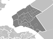
Almere is located in the polder of Southern Flevoland (Dutch: Zuidelijk Flevoland). It is the most western municipality of the province Flevoland. It borders with Lake Marken in the west and north, Lelystad in the northeast, Zeewolde in the east, and Lake Gooi in the south.
Almere consists of six districts (Dutch: stadsdelen), three of which are under construction.[6]
| Name | Year[7] | Location |
|---|---|---|
| Almere Haven | 1976 |  |
| Almere Stad | 1980 |  |
| Almere Buiten | 1984 |  |
| Almere Hout | 1991 |  |
| Almere Poort | 2000 |  |
| Almere Pampus | - |  |
Demography
| Almere Haven | Almere Stad | Almere Buiten | Almere Hout | Almere Poort | Almere Pampus | Almere in total | |
|---|---|---|---|---|---|---|---|
| 1970 | 52 | ||||||
| 1975 | 47 | ||||||
| 1980 | 6596 | 6632 | |||||
| 1985 | 21410 | 17240 | 1559 | 40297 | |||
| 1990 | 22355 | 37024 | 11499 | 71087 | |||
| 1995 | 22376 | 58816 | 22740 | 564 | 104496 | ||
| 2000 | 22237 | 83934 | 35290 | 1336 | 142797 | ||
| 2005 | 22590 | 103560 | 47358 | 1366 | 175008 | ||
| 2007 | 22507 | 105261 | 51751 | 1345 | 134 | 180998 |
Transport
The traffic infrastructure in Almere is recognisable because of its separate infrastructure for cycles (which have separate cycle paths), cars and buses (In Almere the buses drive on a separate bus lane). Almere is connected to the motorways the A6 and the A27.
Railway
In 1987 Almere was connected to the national railway system (see NS) in 1988 with the fully completed Flevolijn which connected Weesp to Lelystad Centrum. Almere currently has five railway stations:
- Almere Muziekwijk (opened in 1987)
- Almere Centrum (opened in 1987)
- Almere Parkwijk (opened in 1996)
- Almere Buiten (opened in 1987)
- Almere Oostvaarders (opened in 2004).
A sixth station for Almere Poort will probably open within 3 years.
Public buses
In Almere there are 10 bus lines which service the urban area:
- 1 Almere Buiten Stripheldenbuurt-Almere Haven De Marken
- 2 CS Almere-Gooisekant
- 3 Almere de Vaart-Almere Haven Centrun
- 4 CS Almere-Almere Poort Columbuskwartier
- 5 Almere Oostvaarders-Almere 't Oor (bus station)
- 6 CS Almere-Almere Parkwijk
- 7 Almere Noorderplassen-Almere Sallandsekant
- 8 CS Almere-Kemphaan
- 9 Almere Buiten-Almere de Vaart
- 10 Almere Buiten- Almere Stad Gooisekant
Most buses run about every 7 minutes. The bus company that runs the buses is called Connexxion and the name of the local bus system is called Maxx Almere owned by Connexxion. In the buses one can use the national bus tickets, subscriptions or one can buy bus tickets of Maxx Almere.
Besides the local bus lines there are regional bus lines to Hilversum, Zeewolde, Harderwijk, Schiphol, Amsterdam Amstel
References
Notes
- ↑ (Dutch) CBS Statline. Retrieved on 2008-06-09.
- ↑ (Dutch) CBS Statline - Bevolking; ontwikkeling in gemeenten met 100 000 of meer inwoners. Retrieved on 2008-06-09.
- ↑ (Dutch) Schaalsprong Almere 2030, PDF. Retrieved on 2008-06-09.
- ↑ (Dutch) Gemeente Almere: Partnersteden. Retrieved on 2008-02-23.
- ↑ (Dutch) Algemene Informatie. Retrieved on 2008-02-23.
- ↑ (Dutch) Gemeente Almere: Stadsdelen. Retrieved on 2008-02-23.
- ↑ (Dutch) Sociale Atlas 2007 Bevolkingsopbouw. Retrieved on 2008-02-23.
External links
- (Dutch) Gemeente Almere (official website)
- Gemeente Almere (English language section of the official website)
- Free foundation with a critical view about Almere
- (Dutch) Geheugen van Almere (people's stories about Almere)
- (Dutch) http://www.almerestadchatbox.nl/ (Chatbox and forum for people in Almere)
|
|||||||||||
