Antalya
| Antalya | |||
|---|---|---|---|
 |
|||
|
|||
 Antalya
|
|||
| Coordinates: | |||
| Country | |||
| Region | Mediterranean | ||
| Province | Antalya | ||
| Government | |||
| - Type | Metropolitan municipality | ||
| - Mayor | Mustafa Akaydın (Republican People's Party) | ||
| Area | |||
| - Total | 1,417 km2 (547.1 sq mi) | ||
| Elevation | 30 m (98 ft) | ||
| Population (2007)[1] | |||
| - Total | 775,157 | ||
| - Density | 478/km2 (1,238/sq mi) | ||
| Time zone | EET (UTC+2) | ||
| - Summer (DST) | EEST (UTC+3) | ||
| Postal code | 07x xx | ||
| Area code(s) | 0242 | ||
| Licence plate | 07 | ||
| Website | http://www.antalya-bld.gov.tr/en | ||

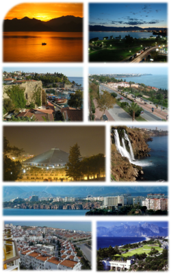
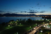
Antalya (from Greek "Αττάλεια" - Attaleia) is a city on the Mediterranean coast of southwestern Turkey, and the capital city of Antalya Province. Situated on coastal cliffs, Antalya is surrounded by mountains. Development and investment, begun in the 1970s, have transformed the city into an international resort.
Contents |
History
It is uncertain when the site of the current city was first inhabited. Attalos II, king of Pergamon, was believed to have founded the city around 150 BC, naming it Attalia and selecting it as a naval base for his powerful fleet. However, excavations in 2008 in the Doğu Garajı district of Antalya have uncovered remains dating to the 3rd century BC, suggesting that the city was founded earlier than previously supposed. Antalya became part of the Roman Republic in 133 BC when King Attalos III of Pergamum willed his kingdom to Rome at his death. The city grew and prospered during the Ancient Roman period.
Christianity started to spread in the region after 2nd century. Antalya was visited by Paul of Tarsus, as recorded in the Acts of the Apostles: "From Perga, Paul and Barnabas went down to Attalia and sailed from there to Antioch after preaching in Pisidia and Pamphylia" (Acts 14:25-26).
Antalya was a major city in the Byzantine Empire. It was the capital of the Byzantine Theme of Carabisiani (Θέμα Kαραβησιάνων, Thema Karavēsianōn), which occupied the southern coasts of Asia Minor and the Aegean Islands. At the time of the accession of John II Comnenus (1118) it was an isolated outpost against the Turks, accessible only by sea.[2] The following year, with the aid of his commander-in-chief John Axuch, John II drove the Turks from the land routes to Antalya and reconnected the city with the rest of the empire.
The city, along with the surrounding region, was conquered by the Seljuk Turks in the early 13th century. Antalya was the capital of the Turkish beylik of Teke (1321–1423) until its conquest by the Ottomans. The Arabic traveler Ibn Battuta who came to the city in between 1335-1340 noted:
From Alanya I went to Antaliya [Adalia], a most beautiful city. It covers an immense area, and though of vast bulk is one of the most attractive towns to be seen anywhere, besides being exceedingly populous and well laid out. Each section of the inhabitants lives in a separate quarter. The Christian merchants live in a quarter of the town known as the Mina [the Port], and are surrounded by a wall, the gates of which are shut upon them from without at night and during the Friday service. The Greeks, who were its former inhabitants, live by themselves in another quarter, the Jews in another, and the king and his court and Mamluks in another, each of these quarters being walled off likewise. The rest of the Muslims live in the main city. Round the whole town and all the quarters mentioned there is another great wall. The town contains orchards and produces fine fruits, including an admirable kind of apricot, called by them Qamar ad-Din, which has a sweet almond in its kernel. This fruit is dried and exported to Egypt, where it is regarded as a great luxury.[3]
In the second half of the 17th century Evliya Çelebi wrote of a city of narrow streets containing 3,000 houses in twenty Turkish and four Greek neighborhoods. The town had grown beyond the city walls and the port was reported to hold up to 200 boats.
In the 19th century, in common with most of Anatolia, its sovereign was a "dere bey" (land lord or landowner). The family of Tekke Oglu, domiciled near Perge, though reduced to submission in 1812 by Mahmud II, continued to be a rival power to the Ottoman governor until within the present generation, surviving by many years the fall of the other great beys of Anatolia. The records of the Levant (Turkey) Company, which maintained an agency in Antalya until 1825, documented the local dere beys.
In the 20th century the population of Antalya increased as Turks from the Caucasus and the Balkans moved into Anatolia. By 1911 it was a city of about 25,000 people, including many Christians and Jews, still living in separate quarters around the walled mina or port. The port was served by coast steamers of local companies. Antalya (then Adalia) was picturesque, but ill-built and backward. The chief attraction for visitors was the city wall, and outside a promenade -a portion of which survives to the present. The government offices and the houses of the higher classes were all outside of the walls.[4]
The city was briefly occupied by the Italians from the end of the First World War until the founding of the Turkish Republic in 1923.
Etymology
According to tradition, in the 2nd century BC, the Pergamum king Attalos II ordered his men to find "heaven on earth". After an extensive search, they discovered the region of Antalya. King Attalos rebuilt the city, giving it the name "Attaleia" (Greek: Αττάλεια) which later mutated in Turkish as Adalia and then Antalya. Attaleia was also the name of a festival at Delphi[5] and Attalis (Greek: Ἀτταλίς) was the name of an ancient Greek tribe at Athens[6].
Demographics

As of the 2009 census, Antalya had a population of 1,095,157 (558,133 men; 537,024 women). The greater metropolitan area totals more than a million in winter.
| Population | |||
|---|---|---|---|
| Years | City | ||
| 2009 | 1,098,507 | ||
| 2007 | 775,157 | ||
| 2000 | 603,190 | ||
| 1990 | 378,208 | ||
| 1985 | 258,139 | ||
| 1970 | 95,000 | ||
| 1965 | 72,000 | ||
| 1960 | 51,000 | ||
| 1955 | 36,000 | ||
| 1950 | 28,000 | ||
| 1945 | 26,000 | ||
| 1940 | 25,000 | ||
| 1935 | 23,000 | ||
| 1927 | 17,000 | ||
Geography
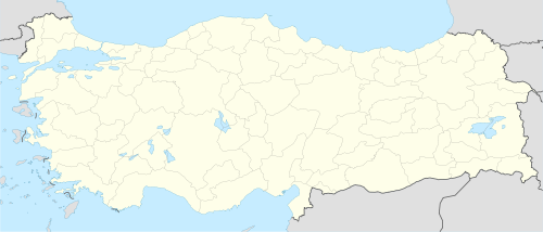
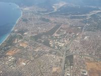
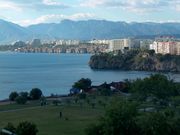
Antalya is in south-west Anatolia, on the Mediterranean Gulf of Antalya, approximately 546 kilometres (339 mi) from Ankara, 562 kilometres (349 mi) from Adana, 466 kilometres (290 mi) from Izmir, and 727 kilometres (452 mi) from Istanbul.
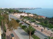
The Taurus mountain range of southern Anatolia runs parallel to the Mediterranean in an east-west direction, resulting in the formation of narrow coastal plains surrounded by mountains on three sides and the sea on the fourth. Some parts of the coast feature mountains plunging sharply into the sea, forming small natural bays and peninsulas. Antalya is situated on one such plain where the mountains recede from the shore, consisting of two flat areas formed of travertine rock at a mean height of 35 metres (115 ft); the town center is located on the rocky plain closest the coast, with urban sprawl extending to the Kepezüstü Plain further inland.
Climate
The area is shielded from the cold northerly winds by the Taurus Mountain range, having a characteristically Mediterranean climate -with hot, dry summers and moderately warm and rainy winters. Around 300 days of the year are sunny; sea temperature range between 15 °C (59 °F) and 28 °C (82 °F); air temperature can climb as high as the 40 °C (104 °F) range in July and August, with the low-to-mid 30 °C (86 °F) typical. The sea breeze and the northeasterly winds help to make high temperatures more bearable.
| Climate data for Antalya | |||||||||||||
|---|---|---|---|---|---|---|---|---|---|---|---|---|---|
| Month | Jan | Feb | Mar | Apr | May | Jun | Jul | Aug | Sep | Oct | Nov | Dec | Year |
| Average high °C (°F) | 14.9 (58.8) |
15.4 (59.7) |
17.7 (63.9) |
21.2 (70.2) |
25.4 (77.7) |
30.5 (86.9) |
33.8 (92.8) |
33.7 (92.7) |
30.9 (87.6) |
26.4 (79.5) |
21.2 (70.2) |
16.7 (62.1) |
21.9 (71.4) |
| Average low °C (°F) | 5.9 (42.6) |
6.2 (43.2) |
7.8 (46) |
11.1 (52) |
15.0 (59) |
19.4 (66.9) |
22.4 (72.3) |
22.3 (72.1) |
19.1 (66.4) |
15.0 (59) |
10.7 (51.3) |
7.6 (45.7) |
13.5 (56.3) |
| Precipitation mm (inches) | 232.4 (9.15) |
160.7 (6.327) |
96.8 (3.811) |
46.2 (1.819) |
30.0 (1.181) |
9.6 (0.378) |
2.2 (0.087) |
2.5 (0.098) |
12.3 (0.484) |
67.7 (2.665) |
131.9 (5.193) |
263.3 (10.366) |
1,055.6 (41.559) |
| Avg. precipitation days | 13 | 11 | 9 | 6 | 5 | 3 | 1 | 1 | 2 | 6 | 8 | 12 | 77 |
| Source: World Weather Information Service[7] | |||||||||||||
Economy
The economy of Antalya used to depend on a mixture of tourism, agriculture, and commerce, with some light industry. Agricultural production includes citrus fruits, cotton, cut flowers, olives, olive oil and bananas. Antalya Metropolitan Municipality’s covered wholesale food market complex meets 65% of the fresh fruit and vegetable demand of Turkey.[8]
Tourism
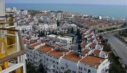
Kaleiçi, the restored historical center of the city -with its hotels, bars, clubs, restaurants, and shopping- retains much of its historical character; its restoration won the Golden Apple Tourism Prize.
The city includes sites with traces of Lycian, Pamphylian, and Hellenistic -but mainly Roman, Byzantine, Seljuk and Ottoman- architecture and cultures.
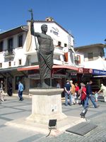
Cumhuriyet Square, the main square of the city, on occasion features temporary open air exhibitions and performances.
Kaleiçi, with its narrow cobbled streets of historic Turkish and Greek houses, is the old center of Antalya- now mainly hotels, gift shops, and bars. New hotels, such as the Sheraton, stand along the coast above the Konyaalti and Lara beaches.
Education
There are a total of 12,000 teachers serving 275,000 students.
Akdeniz University is located here.
Culture

Cuisine
Antalya’s signature cuisine includes Piyaz (made with tahini, garlic, walnuts, and boiled beans), spicy hibeş with mixed cumin and tahini, şiş köfte, tandır kebap, domates civesi, şakşuka, and various cold Mediterranean dishes with olive oil. One local speciality is tirmis, boiled seeds of the lupin, eaten as a snack. "Grida" (also known as Lagos or Mediterrenean white grouper) is a fish common in local dishes.
Festivals and events
- A number of sports championships including motor rallies and the 2010 World Weighlifting Championships.
- Antalya Golden Orange Film Festival: Turkey's largest national film festival, last week of September
- International Eurasia Film Festival: International film festival held annually
- Antalya Festival: September
- Mediterranean International Music Festival: October, 6 days
- Antalya International Folk Music and Dance Festival Competition: Last week of August
- Aspendos International Opera and Ballet Festival: June and July
- Flower festival May
Main sights
Antalya has beaches including Konyaaltı, Lara and Karpuzkaldıran. For winter sports, Beydağları and Saklikent are both natural beauties of the city.
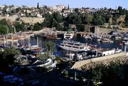
There are a large number of mosques, churches, madrasahs, masjids, hans and hamams in the city. Kaleiçi, the harbor, which the city walls enclose, is the oldest part of the city. Kaleiçi features many historic houses with traditional Turkish and local Greek architecture.
Historic Sites in the city center
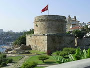
- Kaleici: the historical center of the city.
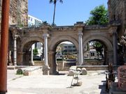
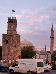
- Ancient monuments include the City Walls, Hıdırlık Tower, Hadrian's Gate (also known as Triple Gate), and the Clock Tower.
- Hadrian's Gate: constructed in the 2nd century by the Romans in honour of the Emperor Hadrian.
- Kesik Minare (Broken Minaret): Once a Byzantine Panaglia church, later converted into a mosque.
- Yivli Minare (Fluted Minaret): Built by Seljuks and decorated with dark blue and turquoise tiles, this minaret eventually became the symbol of the city.
- Karatay Medresesi, Ahi Yusuf Mescidi, and the Iskele, Murat Paşa, Tekeli Mehmet Paşa, Balibey, Musellim, Seyh Sinan Efendi, and Osman Efendi Mosques are other Islamic buildings in the city.
Museums
- Antalya Museum: Prize winning archaeology museum.
- Kaleiçi Museum[9]: Opened in 2007 by the Mediterranean Civilizations Research Center (Akdeniz Medeniyetleri Araştırma Merkezi) see also their annual journal.
Sites of interest
- Karpuzkaldıran
- Tünek Hill
- Karaalioglu Park
- Arapsu Bridge
Transportation
Main transportation to the city is by air and land. Sea routes are still under development.
In 2007, the airport added a new terminal.
The city has a main port at the south of the Konyaaltı. It is planning to launch local routes to Kemer.
Buses
A local bus system serving the greater municipality is operated by a private corporation.
Payment for public transportation was made in cash until the launch of a public transportation card, Antkart, in late 2007. The card system met with criticism and was subsequently canceled in June 2009, returning to a cash system.
In addition, there is a network of Dolmuşes (municipal minibuses).
Rail
A rail connection is in the planning stages since the late Ottoman period.[10]
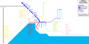
The tram system runs from Antalya Museum and the Sheraton Voyager and Falez hotels, along the main boulevard to the city center at Kalekapisi, Hadrian's Gate, Karaalioglu Park, and ending at Talya Oteli. Trams depart on the hour and half-hour from the terminal (east and west), and reach Kalekapisi between 10 and 15 minutes later.
In December 2009, a 11.1 kilometres (6.9 mi) light rail line Antray was opened from one of the main city public bus hub northwest to the Zoo and beyond to suburban areas.
Major routes
The infrastructure such as roads and drains are struggling to catch up with the increase in population and tourists.
Airports
In 2007, Antalya Airport's number of passengers on international flights surpassed the total number at Istanbul Ataturk Airport and Sabiha Gökçen International Airport for the first time, officially earning the title of "the capital of Turkish tourism".[11][12]
International relations
Twin towns — Sister cities
Antalya is twinned with:
 Bat Yam, Israel
 Cheboksary, Russia
 Famagusta, Republic of Cyprus
- Kazan, Russia
 Nuremberg, Germany
 Muskegon, Michigan, United States
- Rostov-Na-Donu, Russia
 Taldykorgan, Kazakhstan
Notable people from Antalya

- Burak Yilmaz, football player
- Cafercan Aksu, football player
- Coşkun Göğen, film actor
- Deniz Baykal, leader of Turkish Republican People's Party (CHP)
- Özgürcan Özcan, football player
- Deniz Seki, pop musician
- Levent Yüksel, musician, composer
- Michael Attaliates Byzantine lawyer of 11th Century AD.
- Musa Uzunlar, actor
- Onat Kutlar, writer
- Rüştü Reçber, football player
- Sümer Tilmaç, actor
- Tarık Akıltopu, architect, historian, poet, writer
- Yağmur Sarıgül, musician, composer of maNga
References
- ↑ "Yetki Alanı Haritası" (in Turkish). Antalya Metropolitan Municipality Official Web Site. 2007. http://www.antalya.bel.tr/en/bel_kurumsal/yetki_alani_haritasi.cfm. Retrieved 2008-08-25.
- ↑ Norwhich, John Julius. Byzantium: The Decline and Fall. (New York: Alfred A. Knopf, 1996) p. 68.
- ↑ Halsall, Paul (1998-09-05). "Medieval Sourcebook". http://www.fordham.edu/halsall/sbook.html. Retrieved 2008-08-25. "The lemon is still called Addaliya in Egypt."
- ↑ s:EB1911:Adalia
- ↑ Ἀττάλεια, Henry George Liddell, Robert Scott, A Greek-English Lexicon, on Perseus project
- ↑ Ἀτταλίς, Henry George Liddell, Robert Scott, A Greek-English Lexicon, on Perseus project
- ↑ "Weather Information for Antalya". World Weather Information Service. http://www.worldweather.org/014/c00051.htm. Retrieved 1 January 2009.
- ↑ "Covered Wholesale Food Market". Antalya Metropolitan Municipality Official Web Site. http://www.antalya.bel.tr/en/bel_kurumsal/mekanlar/toptanci_hali.cfm. Retrieved 2008-08-25.
- ↑ Kaleiçi Museum
- ↑ "New Ankara train station to upstage Ankamall". Referans (Turkish Daily News). 2008-01-12. http://www.turkishdailynews.com.tr/article.php?enewsid=93340. Retrieved 2008-08-25.
- ↑ "NUMBER OF PASSENGERS IN ANTALYA'S INTERNATIONAL FLIGHTS HIGHER THAN ISTANBUL". World Bulletin. 2007-09-16. http://www.worldbulletin.net/news_print.php?id=10777. Retrieved 2008-08-25.
- ↑ Yanik, Vahide (2007-09-17). "Türkiye uçtu, dünya rekoru kırdı" (in Turkish). DHA (Hürriyet). http://arama.hurriyet.com.tr/arsivnews.aspx?id=7295382. Retrieved 2008-08-25.
 This article incorporates text from a publication now in the public domain: Chisholm, Hugh, ed (1911). Encyclopædia Britannica (Eleventh ed.). Cambridge University Press.
External links
- Antalya travel guide from Wikitravel
- WikiSatellite view of Antalya, WikiMapia
- Weather forecast, Turkish Meteorology Service
|
|||||
|
|||||