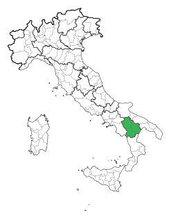
Basilicata
| Basilicata (Lucania) Regione Basilicata (Lucania) |
|||
|---|---|---|---|
| — Region of Italy — | |||
|
|||
 |
|||
| Country | Italy | ||
| Capital | Potenza | ||
| Government | |||
| - President | Vito De Filippo (PD) | ||
| Area | |||
| - Total | 9,995 km2 (3,859.1 sq mi) | ||
| Population (2008-10-31) | |||
| - Total | 590,944 | ||
| - Density | 59.1/km2 (153.1/sq mi) | ||
| Time zone | CET (UTC+1) | ||
| - Summer (DST) | CEST (UTC+2) | ||
| GDP/ Nominal | € 10.5 billion (2006) | ||
| NUTS Region | ITF | ||
| Website | www.regione.basilicata.it | ||

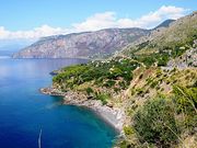
Basilicata or Lucania ([baziliˈka(ː)ta]) is a region in the south of Italy, bordering on Campania to the west, Apulia (Puglia) to the north and east, and Calabria to the south, having one short southwestern coastline on the Tyrrhenian Sea between Campania in the northwest and Calabria in the southwest, and a longer one to the southeast on the Gulf of Taranto on the Ionian Sea between Calabria in the southwest and Apulia in the northeast. The region can be thought of as the "instep" of Italy, with Calabria functioning as the "toe" and Apulia the "heel". The region covers 9,992 km² and in 2008 had a population of less than 600,000 inhabitants. The regional capital is Potenza. The region is divided into two provinces: Potenza and Matera.
Contents |
Geography
Basilicata covers an extensive part of the southern Apennines, between Ofanto in the north and the Monte Pollino massif in the south. It is bordered on the east by a large part of the Bradano river depression which is traversed by numerous streams and declines to the coastal plains on the Ionian sea. The region has a short coastline on the Tyrrhenian side of the peninsula.
Basilicata is the most mountainous region in the south of Italy, with 47% of its area of 9,992 km2 covered by mountains, where as 45% is hilly and 8% is made up of plains.
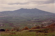
Geological features of the region include the volcanic Monte Vulture and the seismic faults in the Melfi and Potenza areas in the north and around Monte Pollino in the south. Much of the region was devastated in an 1857 earthquake. There is also a problem with landslides, which are caused not only by the lithological structure of the substratum and its chaotic tectonic deformation, but also by the lack of forested land.
The variable climate is influenced by three coastlines (Adriatic, Ionian and Tyrrhenian) and the complexity of the region's physical features. The climate is continental in the mountains and Mediterranean along the coasts.
History
.JPG)
The region was originally known as Lucania, named for the Lucani (Lucanians) tribe, who were the first known settlers. Their name was derived from lucus, Latin for forest. Samnite tribes also inhabited the area before the Greeks invaded in the 7th century BC. The Greeks established settlements at Siris, Metaponto and Heraclea, making the region part of the wider Magna Grecia. They also developed basic agriculture and started trading.
The Romans pushed into Lucania as part of the expansion of their empire and by the 2nd century BC the area was under Roman rule. The Romans were the first to exploit the massive forests of the region, a process which continued for centuries and nearly exhausted this natural resource.
The Byzantines followed the Romans and it was from them that the region was named Basilicata, (from basilikos, "imperial").
In the following centuries the Normans and Swabians also invaded Basilicata. The subsequent 13th century Anjou domination led to the establishment of a feudal system which hampered any hopes of an economic recovery for the region, which remained in abject poverty.
After a century or so under Kingdom of the Two Sicilies domination, Basilicata autonomously declared its annexation to the Kingdom of Italy on August 18, 1860 with the Potenza insurrection. It was during this period that the State confiscated and sold off vast tracts of Basilicata's territory formerly owned by the Church. As the owners were a handful of wealthy aristocratic families the average citizen did not see any immediate economic and social improvements after unification and poverty continued unabated. This gave rise to the phenomenon of brigandage whereby the Church encouraged the local people to rise up against the nobility and the new Italian State. This strong opposition movement continued for many years.
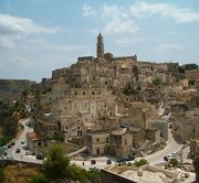
It was only really after the Second World War that things slowly began to improve thanks to land reform. In 1952, the inhabitants of the Sassi di Matera were re-housed by the State, but many of Basilicata’s population had emigrated or were in the process of emigrating, which led to a demographic crisis from which it is still recovering.
At the beginning of 1994, UNESCO declared Sassi di Matera a World Heritage Site. Meanwhile, Fiat Italian automobile manufacturer established a huge factory in Melfi, leading to jobs and an upsurge in the economy. In the same year the Pollino National Park was established.
Economy
Cultivation consists mainly of sowables (especially wheat), which represent 46% of the total land. Potatoes and maize are produced in the mountain areas. Olives and vines are also commonly found. A quality wine called 'Aglianico del Vulture' is produced around Rionero. According to the latest Census of Agriculture, there are large herds of cattle (77,711 heads in 2000)[1].
Among industrial activities, the manufacturing sector contributes to the gross value added of the secondary sector with 64% of the total, while the building sector contributes 24%. Within the services sector, the main activities in terms of gross value added are business activities, distributive trade, education and public administration. In the last years, new productive sectors have developed: manufacture, transport equipment, furnishing, oil extraction[1].
Basilicata has many natural attractions but tourism is poorly developed because of lack of facilities and inadequate transport facilities[1].
Demographics
| Historical populations | ||
|---|---|---|
| Year | Pop. | %± |
| 1861 | 509,000 | — |
| 1871 | 524,000 | 2.9% |
| 1881 | 539,000 | 2.9% |
| 1901 | 492,000 | −8.7% |
| 1911 | 486,000 | −1.2% |
| 1921 | 492,000 | 1.2% |
| 1931 | 514,000 | 4.5% |
| 1936 | 543,000 | 5.6% |
| 1951 | 628,000 | 15.7% |
| 1961 | 644,000 | 2.5% |
| 1971 | 603,000 | −6.4% |
| 1981 | 610,000 | 1.2% |
| 1991 | 611,000 | 0.2% |
| 2001 | 598,000 | −2.1% |
| 2008 (Est.) | 591,000 | −1.2% |
| Source: ISTAT 2001 | ||
Although Basilicata has never had a large population, there have nevertheless been quite considerable fluctuations in the demographic pattern of the region. In 1881, there were 539,258 inhabitants but by 1911 the population had decreased by 11% to 485,911, mainly as a result of emigration overseas. There was a slow increase in the population until the Second World War, after which there was a resurgence of emigration to other countries in Europe, which continued until 1971 and the start of another period of steady increase until 1993 (611,000 inhabitants). In the last years, instead, the population decreased as a result of migration and reduction in the birth rate[2].
The population density is very low compared to that of Italy as a whole: 59.1 inhabitants per km2 compared to 198.8 in 2008. There is not a great difference between the population densities in the provinces of Matera and Potenza[2].
Government and politics
Administrative divisions
Basilicata is divided into two provinces:

| Province | Area (km²) | Population | Density (inh./km²) |
|---|---|---|---|
| Province of Matera | 3,447 | 203,837 | 59.1 |
| Province of Potenza | 6,545 | 387,107 | 59.1 |
Surnames
Twenty most common surnames in the Basilicata region.
|
References
See also
- The novel set in Noepoli in Basilicata, My Heart Was Awake at: http://myheartwasawake.blogspot.com/
External links
- Official Site
- Map of Basilicata
- Pollino Walking Into The Wild Side of Basilicata
- Basilicata autentica
- Basilicata Tourist Office
- Palazzo Rinaldi Artists' Residences in Basilicata
- Basilicata Tourist Office (Sami)
- Documentary Film about the Sassi in Matera, Roba Forestiera, 44 min., 2004
- Sassi di Matera PHOTO Tour
- Basilicata's typical products
- Video introduction to Basilicata
- History, visit and spots of interest of art cities and villages of Basilicata
|
||||||||
|
|||||
|
||||||||||||||||||||||||||||||||||||||||||||||