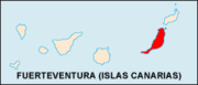
Fuerteventura
| Sobriquet: The place where no-one used to turn to, but now do and Paradise Island | |
|---|---|
 Flag of Fuerteventura |
|
 |
|
| Geography | |
| Location | Atlantic Ocean |
| Archipelago | Canary Islands |
| Total islands | 7 |
| Area | 1,660 km2 (641 sq mi) |
| Highest elevation | 807 m (2,648 ft) |
| Highest point | Pico de Jandía |
| Country | |
|
Spain
|
|
| Autonomous Community | |
| Province | Las Palmas |
| Largest city | Puerto del Rosario (pop. 28,357) |
| Demographics | |
| Population | 74,983 (as of 2003) |
| Density | 45 /km2 (117 /sq mi) |
Fuerteventura (pronounced [fweɾteβenˈtuɾa]), a Spanish island, is one of the Canary Islands, in the Atlantic Ocean off the coast of Africa. It is situated at 28°20' north, 14°00' west. At 1,660 km² it is also the second largest of the islands.
Contents |
History
The first settlers are believed to have arrived here from North Africa - the word Mahorero (Majorero) or Maho is still used today to describe the people of Fuerteventura and comes from the ancient word 'mahos' meaning a type of goatskin shoe worn by the original inhabitants. They lived in caves and semi-subterranean dwellings, a few of which have been discovered and excavated revealing relics of early tools and pottery. In antiquity, the island was known as Planaria, among other names, in reference to the flatness of most of its landscape.
In the 11th century BC, the Phoenician settlers arrived in Fuerteventura and Lanzarote. In 850 BC, the island was mentioned by Homer in the Odyssey, the Canary Islands as Insulae Fortunatae.
Several Spanish and Portuguese expeditions occurred in about 1340 around the island and the island were inhabited by Maurs and were afflicted with European slave holders.
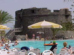
In 1405, the French conqueror Jean de Béthencourt took the island and gave his name to the former capital, Betancuria, on the west coast (Puerto Rosario took over the mantle as island capital in 1835). The name of the island itself is believed to have come from Bethencourt's exclamation "Quelle forte aventure!" ("What a grand adventure").
In 1852, the free trade zone was extended by Isabella II to the Canary Islands. The military rule over the island which began from 1708 dissolved in 1859 and Puerto de Cabras (now Puerto del Rosario) became entirely the new capital.
The Canary Islands obtained the right to self-govern in 1912.
In 1927, Fuerteventura and Lanzarote became part of the province of Gran Canaria.
By the 1940s the island had an airport (just west of Puerto del Rosario on the road to Tindaya, still visible today).
Tourism arrived in the mid-1960s with the building of the present airport at El Mattoral and the first tourist hotels.
The seat of the island government (cabildo insular) is in Puerto del Rosario. A total of 74,983 people (2003) live on the island.
Since the island is close to Africa, many illegal African immigrants try to enter the European Union through it, by a dangerous boat trip from Morocco.
Geography
The elongated island has an area of 1660 km². The island is 100 km long and 31 km wide.
It is part of the province of Las Palmas. It is divided into six municipalities:
- Antigua
- Betancuria
- La Oliva
- Pájara
- Puerto del Rosario
- Tuineje
100 individual settlements are distributed through these municipalities. A nearby islet, Islote de Lobos, is part of the municipality of La Oliva.
Located just 100 kilometres off the coast of North Africa, it is the second biggest of the islands, after Tenerife, and has the longest beaches in the archipelago. The island is a paradise for sun, beach and watersports enthusiasts.
The island is on the same latitude as Florida and Mexico and temperatures here rarely fall below 18 °C (64 °F) or rise above 24 °C (75 °F). There are no fewer than 152 beaches along its coastline - 50 kilometres of fine, white sand and 25 kilometres of black volcanic shingle.
Geology
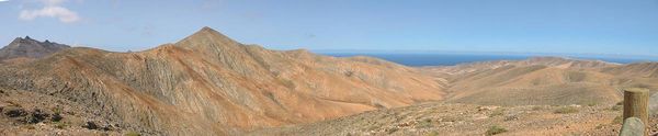
Fuerteventura is the oldest island in the Canary Islands dating back 20 million years to a volcanic eruption from the Canary hotspot. The majority of the island was created about 5 million years ago and since then has been eroded by wind and weather. On the seabed off the west coast of the island rests a block of rock 22 km long and 11 km wide, which appears to have slid off the island largely intact at some point in prehistory, similar to the predicted future collapse of Cumbre Vieja, a geological fault on the neighboring island, La Palma. The last volcanic activity in Fuerteventura was between 4,000 and 5,000 years ago.
The highest point in Fuerteventura is Mount Jandía (807 m) in the southwestern part of the island. Geographical features include Istmo de la Pared which is 5 km wide and is the narrowest part of Fuerteventura. The island is divided into two parts, the northern portion which is Maxorata and the southwestern part called the Jandía peninsula. The island is the least settled in the Canary Islands.
Climate
The climate on Fuerteventura is pleasant throughout the year. The island is also often referred to as the island of eternal spring. The sea adjusts the temperature making the hot Sahara winds blow away from the island. The island's name in English translates as 'strong fortune' or 'strong wind', the Spanish word for wind being 'viento'. During the winter months, temperatures average a high of 22 °C (72 °F) and a low of around 15 °C (59 °F) whereas during the summer a mean high of 35 °C (95 °F) and a low of 20 °C (68 °F) can be expected. Precipitation is about 147 mm per year, most of which falls in the winter.
A sandstorm known as the Calima - (similar to the Scirocco wind that blows North from the Sahara into Europe) - blows to the southwest from the Sahara desert and can cause high temperatures, low visibility and drying air. Temperatures during this phenomenon rise temporarily by approximately 10 degrees Celsius. The wind brings in fine white sand, visibility can drop to between 100 to 200 m (328.08 to 656.17 ft) or even lower and can even bring the African locusts to the island.
Economy

The economy of Fuerteventura is mainly based on tourism. Primary tourist areas are located around the existing towns of Corralejo in the north and Morro Jable in Jandia, plus the purely tourist development of Caleta de Fuste, south of Puerto del Rosario. Other main industries are fishing and agriculture (cereals and vegetables). The famous Majorero cheese is locally made from the milk of the indigenous majorera goat.
Tourism
The first tourist hotel was built in 1965 followed by the construction of Fuerteventura Airport at El Mattoral, heralding the dawn of a new era for the island. Fuerteventura, with its 3,000 sunshine hours a year, was placed firmly on the world stage as a major European holiday destination.
The summer Trade Winds and winter swells of the Atlantic make this a year-round surfers' paradise. Sailors, scuba divers and big-game fishermen are all drawn to these clear blue Atlantic waters where whales, dolphins, marlin and turtles are all common sights.
Much of the interior, with its large plains, lavascapes and volcanic mountains, consists of protected areas which can be best be explored in a 4x4 or (for the more daring) with a cross-country motorbike on an organised tour.
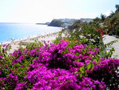
Sites of interest
.jpg)
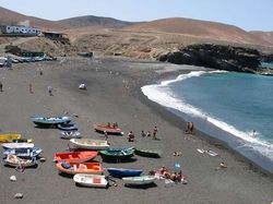
Sites of interest include Corralejo and El Jable to the north which are made up of fine sand dunes whilst the south is filled with long beaches and remote bays. The constant winds blowing onto the beaches provide a paradise for windsurfing. Surfing is common on the west and north coasts where there are large waves. Windsurfing is common around Corralejo and Playas de Sotavento and wave sailing (windsurfing on the waves) on the coast along the northern half of the island.

At Cofete on the western side of Jandía a remote and imposing house - Villa Winter - looks out to sea across wide and generally empty beaches. It was reputedly built by a Mr Winter on land given by Generalisimo Franco.
On 18 January 1994 the SS American Star (former America, USS Westpoint, Australis) was beached in Playa de Garcey during a storm. By 2007 the ship had collapsed onto its side, almost completely submerged. In 2008 the wreck finally slipped below the surface.
See also
- List of volcanoes in Spain
External links
- Aerial photos of Fuerteventura
- Fuerteventura Maps
- Fuerteventura – Official Canary Islands Tourism
- History of the Island
- Fuerteventura images
- Fuerteventura beaches
|
|||||||
|
|||||||||||||