Ganges
| Ganges | |
| River | |
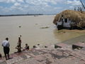
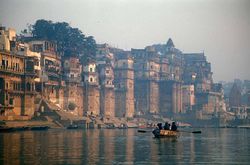 The Ganges in Varanasi
|
|
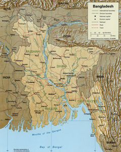
| Countries | India, Bangladesh |
|---|---|
| States | Uttarakhand, Uttar Pradesh, Bihar, Jharkhand, West Bengal |
| Tributaries | |
| - left | Mahakhali, Karnali, Koshi, Gandak, Ghaghra |
| - right | Yamuna, Son, Mahananda |
| Cities | Haridwar, Kanpur, Allahabad, Varanasi, Ghazipur, Patna, Kolkata |
| Source | Gangotri Glacier |
| - location | Uttarakhand, India |
| - elevation | 7,756 m (25,446 ft) |
| - coordinates | |
| Mouth | Ganges Delta |
| - location | Bay of Bengal, Bangladesh & India |
| - elevation | 6 m (20 ft) |
| - coordinates | |
| Length | 2,510 km (1,560 mi) |
| Basin | 907,000 km² (350,195 sq mi) |
| Discharge | mouth |
| - average | 12,015 m3/s (424,306 cu ft/s) |
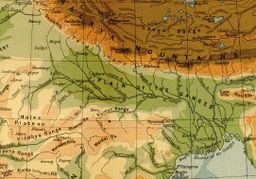 A 1908 map showing the course of the Ganges and its tributaries. Major left-bank tributaries include Gomti (Gumti), Ghaghara (Gogra), Gandaki (Gandak), and Kosi (Kusi); major right-bank tributaries include Yamuna (Jumna), Son, Punpun and Damodar.
|
|
The Ganges (English pronunciation: /ˈɡændʒiːz/ GAN-jeez; Sanskrit: गङ्गा Hindi: गंगा Urdu: گنگا Ganga IPA: [ˈɡəŋɡaː] (![]() listen); Bengali: গঙ্গা Gônga), is the largest river of the Indian subcontinent, flowing east through the Gangetic Plain of northern India into Bangladesh. The 2,510 km (1,560 mi) river rises in the western Himalayas in the Uttarakhand. It has long been considered the holiest of all rivers by Hindus and worshiped as the goddess Ganga in Hinduism. It has also been important historically: many former provincial or imperial capitals (such as Patliputra, Kannauj, Kara, Allahabad, Murshidabad, Berhampore and Calcutta) have been located on its banks. The Ganges Basin drains 1,000,000-square-kilometre (390,000 sq mi) and supports one of the world's highest density of humans. The average depth of the river is 52 feet (16 m), and the maximum depth, 100 feet (30 m). The river has been declared as India's National River.[1] The many symbolic meanings of the river on the Indian subcontinent were spoken to in 1946 by Jawaharlal Nehru in his Discovery of India:
listen); Bengali: গঙ্গা Gônga), is the largest river of the Indian subcontinent, flowing east through the Gangetic Plain of northern India into Bangladesh. The 2,510 km (1,560 mi) river rises in the western Himalayas in the Uttarakhand. It has long been considered the holiest of all rivers by Hindus and worshiped as the goddess Ganga in Hinduism. It has also been important historically: many former provincial or imperial capitals (such as Patliputra, Kannauj, Kara, Allahabad, Murshidabad, Berhampore and Calcutta) have been located on its banks. The Ganges Basin drains 1,000,000-square-kilometre (390,000 sq mi) and supports one of the world's highest density of humans. The average depth of the river is 52 feet (16 m), and the maximum depth, 100 feet (30 m). The river has been declared as India's National River.[1] The many symbolic meanings of the river on the Indian subcontinent were spoken to in 1946 by Jawaharlal Nehru in his Discovery of India:
The Ganges, above all is the river of India, which has held India's heart captive and drawn uncounted millions to her banks since the dawn of history. The story of the Ganges, from her source to the sea, from old times to new, is the story of India's civilization and culture, of the rise and fall of empires, of great and proud cities, of adventures of man…
Contents |
Course
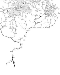
Although many small streams comprise the headwaters of the Ganges, the six longest headstreams and their five confluences are given both cultural and geographical emphasis (see the map showing the headwaters of the river). The Alaknanda river meets the Dhauliganga river at Vishnuprayag, the Nandakini river at Nandprayag, the Pindar river at Karnaprayag, the Mandakini river at Rudraprayag and finally the Bhagirathi river at Devprayag, to form the mainstem, the Ganges. The Bhagirathi is the source stream; it rises at the foot of Gangotri Glacier, at Gaumukh, at an elevation of 3,892 m (12,769 ft). The headwaters of the Alaknanda are formed by snowmelt from such peaks as Nanda Devi, Trisul, and Kamet.
After flowing 200 km through its narrow Himalayan valley, the Ganges debouches on the Gangetic Plain at the pilgrimage town of Haridwar. There, a dam diverts some of its waters into the Ganges Canal, which irrigates the Doab region of Uttar Pradesh. The Ganges, whose course has been roughly southwestern until this point, now begins to flow southeast through the plains of northern India.
Further, the river follows an 800 km curving course passing through the city of Kanpur before being joined from the southwest by the Yamuna at Allahabad. This point is known as the Sangam at Allahabad. Sangam is a sacred place in Hinduism. According to ancient Hindu texts, at one time a third river, the Sarasvati, met the other two rivers at this point.
Joined by numerous rivers such as the Kosi, Son, Gandaki and Ghaghra, the Ganges forms a formidable current in the stretch between Allahabad and Malda in West Bengal. On its way it passes the towns of Kanpur, Soron, Kannauj, Allahabad, Varanasi, Patna, Ghazipur, Bhagalpur, Mirzapur, Ballia, Buxar, Saidpur, and Chunar. At Bhagalpur, the river meanders past the Rajmahal Hills, and begins to run south. At Pakur, the river begins its attrition with the branching away of its first distributary, the Bhāgirathi-Hooghly, which goes on to form the Hooghly River. Near the border with Bangladesh the Farakka Barrage, built in 1974, controls the flow of the Ganges, diverting some of the water into a feeder canal linking the Hooghly to keep it relatively silt-free.
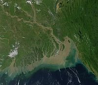
After entering Bangladesh, the main branch of the Ganges is known as the Padma River until it is joined by the Jamuna River, the largest distributary of the Brahmaputra. Further downstream, the Ganges is fed by the Meghna River, the second largest tributary of the Brahmaputra, and takes on the Meghna's name as it enters the Meghna Estuary. Fanning out into the 350 km wide Ganges Delta, it finally empties into the Bay of Bengal. Only two rivers, the Amazon and the Congo, have greater discharge than the combined flow of the Ganges, the Brahmaputra and the Surma-Meghna river system.
Religious significance
Hinduism
Situated on the banks of River Ganga, Varanasi is considered by some to be the holiest city in Hinduism. The Ganga is mentioned in the Rig-Veda, the earliest of the Hindu scriptures. It appears in the Nadistuti sukta (Rig Veda 10.75), which lists the rivers from east to west. In RV 6.45.31, the word Ganga is also mentioned, but it is not clear whether this reference is to the river. Also, people scatter ashes of loved ones here. George Harrison of The Beatles had his ashes scattered in the Ganga by his family in a private ceremony soon after his death.
Some Hindus also believe life is incomplete without taking a bath in Ganga at least once in their lives. Many Hindu families keep a vial of water from the Ganga in their house. This is done because it is prestigious to have water of the Holy Ganga in the house, and also so that if someone is dying, that person will be able to drink its water. Many Hindus believe that the water from the Ganga can cleanse a person's soul of all past sins, and that it can also cure the ill. The ancient scriptures mention that the water of Ganga carries the blessings of Lord Vishnu's feet; hence Mother Ganga is also known as Vishnupadi, which means "Emanating from the Lotus feet of Supreme Lord Sri Vishnu."
Lord Ram
Ganga River is also said to be the river of supreme Lord Rama and also called "Ram Ganga" as there is a belief Lord Ram promised while Gange emerged from his feet that, when He will appear on earth as Lord Ram will reside on the banks of Ganga and her tributaries. Lord Ram then appeared in Ayodhya which is on the banks of Saryu Ganga River, When he went to Janakpuri he crossed River Ganga in Haridwar. During his 14 years exile with wife Sita and brother laxman after leaving Ayodhya his first night stay was at Tamsa River (Ganga tributaries), his second stay was at Shrungverpur which is on the banks of Ganga and with the help of Nishadraj Gruh and Kevat he crossed Ganga , he then went to Triveni sangam, Prayag Raj stayed with Muni Bharadvaj and then marched towards Chitrakut and stayed there for 11 and half years on Kamadgiri parvat on the banks of Mandakini River. From there he went to Panchvati and stayed on the bank of Godavari until his wife sitaji was abducted by demon king Ravana. The search for his beloved wife Sita, lord Rama went to Rameshwaram , as it is said all rivers meet the bay of bengal.
Ganges in popular folklore
It is also believed that when Lord Rama installed and worshiped the Jyoti Ling of Lord Shiv in Rameshwaram River Ganga emerged from the Lotus feet of Lord Rama and then Lord Rama did abhishek of Shivlingam declaring "who so ever will worship by pouring Ganga Jal on this Shivling ,I will give them moksha from all sins and will be freed even from the deadlist sins of killing Cows or Bhramins".
In the Mahabharata, while explaining to Arjuna the mahima (greatness) of the 12 Jyotirlingas, Lord Shiva said that any devotee who worships my Jyotirling in Rameshwaram with Gangajal, the water of the Ganges, will attain the moksha that even the demigods (devtas) cannot attain.
Kumbha Mela
Some of the most important Hindu festivals and religious congregation (worship) happen here. Congregations are celebrated on the banks of the river Ganga, such as the Kumbh Mela every twelve years at Media:Allahabad and the Chhath Puja.
Varanasi
Varanasi has hundreds of temples along the banks of the Ganga which often become flooded during the rains. This city, especially along the banks of the Ganga, is an important place of worship for Hindus as well as a cremation ground.
Legend of Bhagirath
According to Hindu religion a very famous king Bhagiratha did Tapasya for many years constantly to bring the river Ganga, then residing in the Heavens, down on the Earth to find salvation for his ancestors, who were cursed by a seer. Therefore, Ganga descended to the Earth through the lock of hair (Jata) of god Shiva to make whole earth pious, fertile and wash out the sins of humans.[2] For Hindus in India, the Ganga is not just a river but a mother, a goddess, a tradition, a culture and much more.
Dams
There are two major dams on the Ganges. One at Haridwar diverts much of the Himalayan snow-melt into the Upper Ganges Canal, built by the British in 1854 to irrigate the surrounding land. This caused severe deterioration to the water flow in the Ganges, and is a major cause for the decay of Ganges as an inland waterway.
The other dam is a serious hydroelectric affair at Farakka, close to the point where the main flow of the river enters Bangladesh, and the tributary Hooghly (also known as Bhagirathi) continues in West Bengal past Calcutta. This barrage, which feeds the Hooghly branch of the river by a 26 mile long feeder canal, and its water flow management has been a long-lingering source of dispute with Bangladesh, which fortunately is likely to be resolved based on discussions held with the new Hasina government in Bangladesh in 1996 when I.K. Gujral was the Foreign Minister in India, Failure to resolve this has caused harm to both sides of the border for nearly two decades now. Bangladesh feels that the lack of flow in the summer months causes sedimentation and makes Bangladesh more prone to flood damages. At the same time, proposals for linking the Brahmaputra to the Ganges to improve the water flow in the Ganges is hanging fire. Also, the water management problem may actually involve a number of other riparian countries such as Nepal, where there has been tremendous deforestation, leading to greater silt content.
It is likely that Ganges carried more water around the time of the Roman Empire, when Patna was the major port city of Pataliputra. Even in the eighteenth century the ships of the East India Company would come to call at the port city of Calcutta, and the British ran a steamer line all the way to Allahabad. Now only smaller ocean traffic can make it through the Hooghly to Calcutta, beyond which the silting prevents all deep-draft vessels.
A tributary of the , the Haldi River, flows south and meets the Hooghly river (Ganges) at the growing port of Haldia. Damodar, another important tributary of Ganges, meets the river near Bagnan, Howrah. Damodar , popularly known as "Sorrow of Bengal" due to its frequent floods, is having the large hydroelectric dam called Damodar Valley Project, built on the lines of the Tennessee Valley Authority. There is also a controversial dam at Tehri, on the Bhagirathi, one of the main source rivers of Ganges.
Another dam is proposed to be built on the upper reaches of a tributary of the Ganges, Mahakali, This Indo-Nepal project, the Pancheswar dam, proposes to be the highest dam in the world and will be built with US collaboration.
The upper and lower Ganges canal, which is actually the backbone of a network of canals, runs from Haridwar to Allahabad, but maintenance has not been very good.
Tehri Dam is also constructed on Bhagirathi river, tributary of Ganges. Main purpose was to supply water to New Delhi.
Run of the river Hydro Project
There are few run of the river hydro projects are under construction on tributories of the Ganges. Three are being made by NTPC Limited. These are:
1. Loharinag Pala Hydro Power Project by NTPC Ltd: In Loharinag Pala Hydro Power Project with a capacity of 600 MW (150 MW x 4 Units). The main package has been awarded. The present executives' strength is 100+. The project is located on the Bhagirathi tributory in Uttarkashi district of Uttarakhand state. Vinod Kotiya is working here to set up basic IT infrastructure. This is 1st project in downstream from origin of Ganges at Gangotri.
2. Tapovan Vishnugad Hydro Power Project by NTPC Ltd: In joshimath city
3. Lata Tapovan Hydro Power Project by NTPC Ltd: Also in Joshimath
4. Maneri Tiloth Hydro Power Project by UJVNL Ltd: In uttarkashi of 90 MW since 1984
5. Maneri Bhali Hydro Power Project by UJVNL Ltd
History
During the early Vedic Age, the Indus and the Sarasvati River were the major rivers, not the Ganges. But the later three Vedas seem to give much more importance to the Ganges, as shown by its numerous references.
Possibly the first Westerner to mention the Ganges was Megasthenes (ca. 350 – 290 BCE+. He did so several times in his work Indica: "India, again, possesses many rivers both large and navigable, which, having their sources in the mountains which stretch along the northern frontier, traverse the level country, and not a few of these, after uniting with each other, fall into the river called the Ganges. Now this river, which at its source is 30 stadia broad, flows from north to south, and empties its waters into the ocean forming the eastern boundary of the Gangaridai, a nation which possesses a vast force of the largest-sized elephants." (Diodorus II.37)
In Rome's Piazza Navona, a famous sculpture, Fontana dei Quattro Fiumi (fountain of the four rivers) designed by Gian Lorenzo Bernini was built in 1651. It symbolizes four of the world's great rivers (the Ganges, the Nile, the Danube, and the Río de la Plata), representing the four continents known at the time.
Economy
The Ganges Basin with its fertile soil is instrumental to the agricultural economies of India and Bangladesh. The Ganges and its tributaries provide a perennial source of irrigation to a large area. Chief crops cultivated in the area include rice, sugarcane, lentils, oil seeds, potatoes, and wheat. Along the banks of the river, the presence of swamps and lakes provide a rich growing area for crops such as legumes, chillies, mustard, sesame, sugarcane, and jute. There are also many fishing opportunities to many along the river, though it remains highly polluted.
Tourism is another related activity. Three towns holy to Hinduism – Haridwar, Allahabad, and Varanasi – attract thousands of pilgrims to its waters. Thousands of Hindu pilgrims arrive at these three towns to take a dip in the Ganges, which is believed to cleanse oneself of sins and help attain salvation. The rapids of the Ganges also are popular for river rafting, attracting hundreds of adventure seekers in the summer months.
People
Chars are temporary islands formed by the deposition of sediments eroded off the banks of the river in the State of West Bengal. They each accumulatingly provide dwelling ground to up to 20,000 destitute people. The soil they are made of is very fertile, thus suitable for growing crops and pastures to feed cattle on, but it may disappear in a matter of a few hours, following any river water surge, particularly during the Monsoon season. The people living on chars are either Bangladeshi refugees or Bengalis, therefore the Government of West Bengal does not acknowledge their de facto existence, nor does it issue the ID cards they would need aged 14 to emigrate and find jobs on the mainland. Sanitation on the islands is very poor and char-dwellers do not benefit from health care; also, schooling is not provided, so illiteracy is widespread. The Inland revenue demands nevertheless they pay tax.[3]
Pollution and ecology
The Ganges river has been considered one of the dirtiest rivers in the world.[4] The extreme pollution of the Ganges affects 400 million people who live close to the river.[5] The river waters start getting polluted right at the source. The commercial exploitation of the river has risen in proportion to the rise of population. Gangotri[6] and Uttarkashi are good examples too. Gangotri had only a few huts of Sadhus until the 1970s[7] and the population of Uttrakashi has swelled in recent years. As it flows through highly populous areas the Ganges collects large amounts of human pollutants, e.g., Schistosoma mansoni and faecal coliforms, and drinking and bathing in its waters therefore carries a high risk of infection. While proposals have been made for remediating this condition, little progress has been achieved. In December 2009 the World Bank agreed to loan India US$1 billion over the next five years to clean up the Ganges.[8]
Along the 4 miles (6.4 kilometres) stretch of terraced bathing ghats in the holy city of Varanasi, the water of the Ganges is a "brown soup of excrement and industrial effluents."[9] The water there contains 60,000 faecal coliform bacteria per 100 ml, 120 times the official limit of 500 faecal coliforms/100ml that is not considered safe for bathing.[9]
The Ganges river's long-held reputation as a purifying river appears to have a basis in science. First of all, the river carries bacteriophages that vanquish bacteria and more. As reported in a National Public Radio program, dysentery and cholera are killed off, preventing large-scale epidemics. The river has an unusual ability to retain dissolved oxygen, but the reason for this ability is unknown.[10]
The effects of climate change on the river
The Tibetan Plateau contains the world's third-largest store of ice. Qin Dahe, the former head of the China Meteorological Administration, said that the recent fast pace of melting and warmer temperatures will be good for agriculture and tourism in the short term; but issued a strong warning:
"Temperatures are rising four times faster than elsewhere in China, and the Tibetan glaciers are retreating at a higher speed than in any other part of the world.... In the short term, this will cause lakes to expand and bring floods and mudflows. . . . In the long run, the glaciers are vital lifelines for Asian rivers, including the Indus and the Ganges. Once they vanish, water supplies in those regions will be in peril."[11]
In 2007, the Intergovernmental Panel on Climate Change (the "IPCC"), in its Fourth Report, stated that the Himalayan glaciers which feed the Ganges, were at risk of melting by 2035.[12] The IPCC has now withdrawn that prediction, as the original source admitted that it was speculative and the cited source was not a peer reviewed finding.[13] In its statement, the IPCC stands by its general findings relating to the Himalayan glaciers being at risk from global warming (with consequent risks to waterflow into the Gangetic basin).
Water shortages
Along with ever-increasing pollution, water shortages are getting noticeably worse. Some sections of the river are already completely dry. Around Varanasi the river once had an average depth of 60 metres (197 ft), but in some places it is now only 10 metres (33 ft).[14]
- "To cope with its chronic water shortages, India employs electric groundwater pumps, diesel-powered tankers and coal-fed power plants. If the country increasingly relies on these energy-intensive short-term fixes, the whole planet's climate will bear the consequences. India is under enormous pressure to develop its economic potential while also protecting its environment—something few, if any, countries have accomplished. What India does with its water will be a test of whether that combination is possible."[15]
Photo gallery
 The Bhagirathi river, the source stream of the Ganges, in Gangotri, Uttarakhand, India. |
 The Bhagirathi river (foreground) soon to meet the Alaknanda, at Devprayag, and to flow on as the Ganges. |
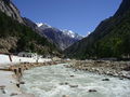
 A bend in the Ganges river, Garhwal hills, Uttarakhand. |
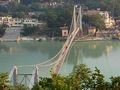 Ramjhula bridge over the Ganges in Rishikesh. |
 Devprayag the confluence of Bhagirathi and Alaknanda rivers Ganga gets the name "Ganga" beyond Devprayag |
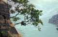 Trees overhang as Ganga flows through a gorge |
 The rock formation at the bend in Ganga at Kodiyala |
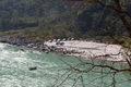
_at_Kodiyala.jpg) Whitewater on Ganga near Kodiyala |
 A rafting camp on the banks of Ganga near town of Rishikesh |
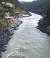
 The Ganga in Haridwar, Uttarakhand, as it leaves the Siwalik Hills for the Gangetic plain. |
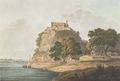 Aqua tint (1804) of the Ganga river in the town of Dalmau, near Raebareli, in present-day central Uttar Pradesh. |
|
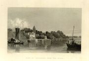
 Pen-and-ink and wash drawing (1803) of the Ganga below the town of Kara, a major provincial capital during the rule of the Delhi Sultanate. |
 The Triveni confluence, of the Ganges and the Yamuna, in Allahabad, Uttar Pradesh. |
||
 Final course(s) of the Ganges; at the Farakka Barrage, a small channel is widened and diverted towards Kolkota as the Bhagirathi-Hoogly river. |
 Watercolor (1840) of the Nizaamat Qila (Criminal Court) of the Nawab of Bengal along the banks of the Bhagirathi-Hoogly river in Murshidabad. |
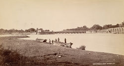
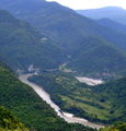
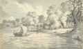
 View of the Ganges near Patna |
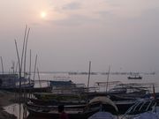
 The Bhagirathi-Hoogly river, shown here at the Bagbazaar Ghat, Kolkota. |
 The main channel of the Ganges in its penultimate form as the Padma river in Bangladesh |
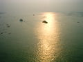 The Ganges in its final form as the Meghna river in Bangladesh. |

See also
- Ganges Basin
- Ganges Fan
- Swach Ganga (Clean Ganges) Campaign
- Indus River
Notes
- ↑ "National River - National Symbols - Know India: National Portal of India". India.gov.in. http://india.gov.in/knowindia/national_river.php. Retrieved 2010-07-16.
- ↑ Mahabharata, Book 3, Sections 107-109.
- ↑ "Wandering Gaia". "The Give and Take of the Ganges". http://www.wanderinggaia.com. Retrieved 2009-04-13.
- ↑ "The World's Dirty Rivers". Time. 22 January 2007. http://www.time.com/time/health/article/0,8599,1581251,00.html. Retrieved 3 May 2010.
- ↑ "June 2003 Newsletter". Clean Ganga. http://www.cleanganga.com/newsletter/index.php. Retrieved 2010-07-16.
- ↑ Swami Sundaranand Himalaya: Through the Lens of a Sudu Published August 2001 ISBN 81-901326-0-1
- ↑ Swami Sundaranand,Himalaya: Through the Lens of a Sudu Published August 2001 ISBN 81-901326-0-1 Page 252
- ↑ "World Bank loans India $1bn for Ganges river clean up"
- ↑ 9.0 9.1 "India and pollution: Up to their necks in it", The Economist, 27 July 2008.
- ↑ Self-purification effect of bacteriophage, oxygen retention mystery: Mystery Factor Gives Ganges a Clean Reputation by Julian Crandall Hollick. National Public Radio.
- ↑ Global warming benefits to Tibet: Chinese official. Reported 18/Aug/2009.
- ↑ See s. 10.6 of the WGII part of the report at
- ↑ The IPCC report is based on a non-peer reviewed work by the World Wildlife Federation. They, in turn, drew their information from an interview conducted by New Scientist with Dr. Hasnain, an Indian glaciologist, who admitted that the view was speculative. See: [1] and [2] On the IPCC statement withdrawing the finding, see: [3]
- ↑ "How India's Success is Killing its Holy River." Jyoti Thottam. Time Magazine. July 19, 2010, pp. 12-17.
- ↑ "How India's Success is Killing its Holy River." Jyoti Thottam. Time Magazine. July 19, 2010, p. 15.
References
- Alley, Kelly D. (2002). On the Banks of the Ganga: When Wastewater Meets a Sacred River. University of Michigan press. ISBN 0-472-06808-3.
- Alter, Stephen (October 2001). Sacred Waters: A Pilgrimage up the Ganges River to the Source of Hindu Culture. . Harcourt. ISBN 0-15-100585-0.
- Berwick, Dennison. A Walk Along the Ganges.
- Darian, Steven G (1978). The Ganges in Myth and History. The University Press of Hawaii, Honolulu. ISBN 0-8248-0509-7.
- Newby, Eric (1966). Slowly down the Ganges. ISBN 0-86442-631-3.
- Hillary, Edmund (November 1980). From the Ocean to the Sky: Jet Boating Up the Ganges. Ulverscroft Large Print Books Ltd. ISBN 0-7089-0587-0.
- Singh, Vijay (1994). The River Goddess. Moonlight Publishing, London.
External links
- ON THINNER ICE 如履薄冰: signs of trouble from the Water Tower of Asia, where headwaters feed into all the great rivers of Asia (by GRIP, Asia Society and MediaStorm)
- Ganges in the Imperial Gazetteer of India, 1909
- Melting Glaciers Threaten Ganges
- Bibliography on Water Resources and International Law. Peace Palace Library
- Ganges as the River of India
- An article about the land and the people of Ganges
|
|||||||||||