Goražde
| Goražde | |||
|---|---|---|---|
 |
|||
|
|||
 |
|||
 Goražde
|
|||
| Coordinates: | |||
| Country | |||
| Canton | Bosnian Podrinje Canton | ||
| Government | |||
| - Municipality president | Muhamed Ramović (SBiH) | ||
| Population (2009) | |||
| - Total | 30,624 | ||
| - Density | 123.6/km2 (320.1/sq mi) | ||
| Time zone | CET (UTC+1) | ||
| - Summer (DST) | CEST (UTC+2) | ||
| Area code(s) | +387 38 | ||
| Website | http://www.gorazde.ba | ||
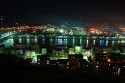
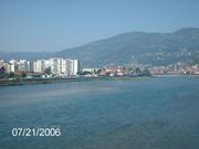
Goražde is a city and municipality in eastern Bosnia and Herzegovina on the Drina river. It is located between Foča, Sokolac and Višegrad, and is administratively part of the Federation of Bosnia and Herzegovina and the center of the Bosnian Podrinje Canton.
Contents |
Location
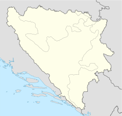
Goražde is situated on the banks of the River Drina in South East Bosnia (see maps). The city lies at the foot of the eastern slope of mountain Jahorina at a height of 345m above sea level. The settlement is situated on the alluvial terrace in a broad valley, formed by the erosion of the River Drina. The valley is bordered on the South-Last by Biserna (701 m), on the South by Samari (696 m), on the South-West by Misjak (618 m), on the West by Gubavica (410 m) and on the North by Povrsnica (420 m).
The River Drina flows between these and some other hills and thus with its valley gives Goražde good communications. The valley of the Drina is the principal traffic artery in the south-eastern region of Bosnia. Since old times it has been part of the important route going from the sea inland (Dubrovnik - Trebinje - Gacko - Foča - the Drina valley). This route was particularly significant in Roman times and in the Middle Ages when it was used by Dubrovnik people travelling to these parts of Bosnia and further on to Serbia (the Dubrovnik road). At Goražde this road meets another coming from Sarajevo and central Bosnia via the Jabuka Mountain pass down to the Drina valley and preceding on to Plevlje. Goražde in Bosnia and Herzegovina was industrial city ranked 1 by year 1990.
Geographical location
The seat of the municipality of the same name, the city of Gorazde, located in the central part of the headwaters of the river Drina. He has a very good geographical and strategic position, was the scene of conflict, large armies across the story of his life. Sunset in eastern and southern slopes of Mount Jahorina, and the western slopes of the mountain Vucevica. On a topographic map with its appearance recalls the lizard. The average altitude of 345 meters east. The poet would have noticed that the city lies on both banks of the River Drina, which are connected by bridges Drina (3). Outside the city there are many forest areas in the beautiful city itself is very pretty park, beside which flows provocative beauty of Drina, 1.5 km downstream from the city loses its name and passes into the reservoir known as the Visegrad's lake. On a regional city located in the eastern highlands of south-eastern Bosnia, the Dinaric direction in which the highest mountain of Dinarides of Bosnia-Herzegovina. Highlands is a very articulated a deep valley of the Drina River and its tributaries, which are generally shaped gorges and canyons. By 1992 he was an unhappy e industrial center developed a small industrial units in the valley of the Drina. Administrative Centre, Cultural and Educational upper Drina, completely marginalized and forgotten in the political constellations, which are present in Bosnia-Herzegovina, it has lost its military actions is a natural basin. The city is located in a valley-long expansion of 8.6 km and an average width of 1.2 km. The origin of this expansion was mainly caused by the effect of erosion-denudation of the Drina River, primarily, and its tributaries (Rijeka, Podhranjenski Creek on the left, and Kolijevacki, Zupcicki creek on the right side ). In terms of morphological expansion of this valley is framed by the hills south-east (701 m) Biserna-(Pearl) Samarima(Breath)-south (696 m) southwest Misijak (618 m) west Gubavica (410 m), north and Povrsnica (420 m) and Trovrh the northeast (1212 m), Petibor (1184 m) and the Grad-(City)(1093 m). For the origin and development of the town were very large natural resources not only topographic position, soil fertility, and social institutions, major roads, etc. Given the proximity of Foca and Visegrad before mentioned in the documents Historical from Gorazde has been established as a settlement on the site range gravitational field of these two cities as centers of agricultural land and livestock, the natural intersection of Highways at the time of the four directions.
Settlements
• Ahmovići • Bačci • Bahovo • Bakije • Bare • Bašabulići • Batkovići • Bezmilje • Biljin • Blagojevići • Bogdanići • Bogušići • Borak Brdo • Borova • Borovići • Bosanje • Boškovići • Brajlovići • Bratiš • Brekovi • Brezje • Brijeg • Bučje • Budići • Butkovići • Butkovići Ilovača • Crvica • Čitluk • Čovčići • Čurovi • Ćatovići • Ćehajići • Deševa • Donja Brda • Donja Bukvica • Donje Selo • Donji Bogovići • Dragolji • Dragovići • Dučići • Džindići • Džuha • Đakovići • Faočići • Gaj • Glamoč • Gočela • Gojčevići • Goražde • Gornja Brda • Gornja Bukvica • Gornji Bogovići • Grabovik • Gradac • Gunjačići • Gunjevići • Gusići • Guskovići • Hadžići • Hajradinovići • Hladila • Hrančići • Hrid • Hrušanj • Hubjeri • Ilino • Ilovača • Jabuka • Jagodići • Jarovići • Kalac • Kamen • Kanlići • Karauzovići • Karovići • Kazagići • Knjevići • Kodžaga Polje • Kola • Kolijevke • Kolovarice • Konjbaba • Konjevići • Kopači • Kosače • Kostenik • Kovači • Kraboriš • Krašići • Kreča • Kučine • Kušeši • Kutješi • Laleta • Lukarice • Ljeskovik • Markovići • Mašići • Milanovići • Mirvići • Mirvići na Podhranjenu • Morinac • Mravi • Mravinjac • Mrkovi • Nekopi • Nevorići • Novakovići • Odžak • Orahovice • Oručevac • Osanica • Osječani • Ostružno • Ozrenovići • Paraun • Perjani • Pijestina • Pijevac • Plesi • Podhomara • Podhranjen • Podkozara Donja • Podkozara Gornja • Podmeljine • Poratak • Potrkuša • Pribjenovići • Prisoje • Prolaz • Pršeši • Radići • Radijevići • Radmilovići • Radovovići • Raškovići • Ratkovići • Rešetnica • Ropovići • Rosijevići • Rusanj • Sedlari • Seoca • Sijedac • Skravnik • Slatina • Sofići • Sopotnica • Spahovići • Surovi • Šabanci • Šašići • Šehovići • Šemihova • Šovšići • Šućurići • Trebeševo • Tupačići • Uhotići • Ušanovići • Ustiprača • Utješinovići • Vitkovići • Vlahovići • Vlajčići • Vraneši • Vranići • Vranpotok • Vrbica • Vremci • Vučetići • Zabus • Zakalje • Zapljevac • Završje • Zemegresi • Zidine • Zorlaci • Zorovići • Zubovići • Zubovići u Oglečevi • Zupčići • Žigovi • Žilići • Žitovo • Živojevići • Žuželo
Population / Demographics
| Ethnic composition | |||||||||||||
| Year | Serb | % | Muslims | % | Croats | % | Yugoslavs | % | Others | % | Total | ||
|---|---|---|---|---|---|---|---|---|---|---|---|---|---|
| 1961 | 9,569 | 30.57% | 19,305 | 61.67% | 314 | 1.00% | 1,501 | 4.80% | 614 | 1.96% | 31,303 | ||
| 1971 | 9.293 | 26.79% | 24,544 | 70.76% | 179 | 0.51% | 168 | 0.48% | 501 | 1.46% | 34,685 | ||
| 1981 | 9,107 | 24.66% | 25,142 | 68.09% | 99 | 0.27% | 2,017 | 5.46% | 559 | 1.51% | 36,924 | ||
| 1991 | 9,844 | 26.25% | 26,316 | 70.17% | 83 | 0.22% | 776 | 2.07% | 486 | 1.30% | 37,505 | ||
In 2005, 91% of population of the municipality were ethnic Bosniaks.
The city of Goražde itself had 18,752* (total agglomeration 27,386) residents in 1991:
Environment
Natural environment
The surrounding region of Goražde is composed of Paleozoic slate, sandstone, carbon and perm. The hills are for the most part rounded and with gentle slopes. The higher ones are composed of limestone. Goražde with its surroundings has mainly equable and fresh mountainous climate. The average annual temperature of the air is 10.8 C and the rainfall is fairly evenly distributed throughout the year. The town is supplied with water from six springs. One part of the inhabitants gets drinking water from ordinary wells. The construction of a water supply system began in 1962. from the spring in Cajnice, 16.5 km (10.3 mi) from Goražde.
The River Drina has great significance for the founding and the development of Goražde. The greatest floods recorded since the 18th century occurred in 1677, 1731, 1737 and in 1896.
Built environment
The main characteristic of the layout and the type of town is its elongated shape along the Ustipraca-Foča road. Form 1465 till 1878 Goražde was part of the Turkish Empire. In the 18th and 19th centuries Goražde was inhabited by Muslim and Orthodox communities. Up to World War II there existed two separate parts: Muslim and Orthodox. Today this division is disappearing. After World War II the town began to expand and be modernized, New streets have been built, public and residential buildings have been built in the centre and in the outskirts as well. From 1945 to 1961, 1130 council flats and 680 private homes have been built. In 1961 there were 616 buildings altogether in the town.
History
Medieval period

With Gornje Podrinje Goražde was part of the old Serbian State up to 1376, when it was attached to the Bosnian State under the reign of King Tvrtko. After Tvrtko's death the town was ruled by the Hum Dukes among whom the best known was Herzog Stjepan.
In 1379, Goražde was first mentioned as a trading settlement and in 1444 as a fortress. The origin of the town's name seems to have come from the Slavonic word "gorazd"
The Goražde market became well known in 1415 when merchants from Dubrovnik had intensive commercial relations with it.
Ottoman rule
The Turks took Goražde over definitively in 1465 and the place assumed oriental features. In 1477 there were four mahals in town. From 1550-1557 Mustafa Sokolovic built a stone bridge across the Drina and a caravanserai.
During the Turkish rule Goražde was a significant trading centre, being at the crossroads of the two important roads: the Bosnian and the Dubrovnik. The gross state income from land amounted in 1477 to 24,256 akchi. In 1711 Goražde was mentioned as the Turkish zoimat of 26,000 akchi.
Two mosques built by the Sijercic begs date back to the 18th century. Near Goražde there is an Orthodox church, built in 1446 by Herzog Stjepan. A printing press, attached to the church, worked there from 1521 till 1531. This was the first printing press to be established in Bosnia and Herzegovina and the second in the Balkans.
Photo: One of the first documents ever printed in Bosnia and Herzegovina, in year 1521. Printing begun with materials used in Sopotnica church.
The decline of Goražde in the 18th century and the first half of the 19th century is attributed among other things to the plague. Up to the middle of the 19th century Goražde was part of the Herzegovinian Sandzak, when it became part of the Sarajevo Sandzak
The period of the Austro-Hungarian occupation was marked by the decline of Goražde, although there was at the same time a certain ascent. Due to its geographical position on the border Goražde was during World War I one of the main strongholds of Austria-Hungary used against Serbia and Montenegro.
Yugoslavia
In pre-war Yugoslavia Goražde, being no more a frontier town, had normal conditions under which to develop and prosper.
In 1941 German troops entered the town after an air-raid on April 17. Later on Italian troops were also stationed there.
The National Liberation Army took over the town for the first time on January 27, 1942, and remained there until May of the same year. During this period National Liberation Committees were formed for the town the district of Goražde on the basis of the Foča Stipulations. At the same time Goražde was the headquarters of the National Liberation Army for East Bosnia. Early in March, 1942 the Commander-in-Chief, Marshal Tito stayed in Goražde. Goražde was liberated twice more, in 1943 and 1944, and on March 6, 1945 it was finally liberated from the occupation.
The composition of the Goražde population can be traced from the times of Austro-Hungarian occupation. The Orthodox inhabitants originate from Stari Vlah in Sandzak, Brda in Montenegro, Herzegovina and South Serbia The few ancestral inhabitants exempted, the Muslim. population began to come in great numbers to Goražde and its surroundings in the 17th century.
From the end of the war till 1961 a considerable number of new groups of families came to live in Goražde from the neighbouring villages and from some other far away places, having been attracted by the economic growth of Goražde. According to the census of 1961 Goražde had 8,812 inhabitants.
Before World War II the industry of Goražde comprised mainly retail trade and in some measure wholesale trade, the catering industry, handicraft, transport. During the occupation, 1941–1945, industry was destroyed and about 45% of the existing houses as well.
Since then Goražde's industry has been systematically developing, its main branches being manufacturing, building, transport, trade and crafts. In 1981 Gorazde's GDP per capita was 70% of the Yugoslav average.[1]
After the II World War a new period, marked by a tremendous social and economic rise began. A number of new industrial enterprises have been founded, among which the most significant is the Nitrogen Factory.
After breakup of Yugoslavia
From 1992 to 1995 during the Bosnian war, Goražde was one of six Bosniak enclaves, along with Srebrenica and Žepa, surrounded and besieged by the Bosnian Serb Army. In April 1993 it was made into a United Nations Safe Area in which the United Nations was supposed to protect the civilian population from attack. Between March 30 and April 23, 1994, the Serbs launched a major offensive against the town. The peacekeepers were ordered to retreat by the UN and as a result of this 694 soldiers and civilians were killed and another 1,917 were wounded before the offensive was stopped. The majority of the casualties were civilians. The city held out until the end of the war and in the end it was to become the only town in eastern Bosnia not to be ethnically cleansed by the Serbs. After the Dayton accords were negotiated a land corridor was established between Goražde and the Federation.
See also
- Safe Area Goražde
References
- ↑ Radovinović, Radovan; Bertić, Ivan, eds (1984) (in Croatian). Atlas svijeta: Novi pogled na Zemlju (3rd ed.). Zagreb: Sveučilišna naklada Liber.
External links
- Official Website (Bosnian)
- Goražde Community portal (Bosnian)
- Goražde Info website
|
|||||||
|
||||||||||||||||||||||||||||||||||||||||||||||||||||||||||