Harstad
| Harstad kommune | |||
|---|---|---|---|
| — Municipality — | |||
 |
|||
|
|||
 |
|||
| Coordinates: | |||
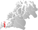
| Country | Norway | ||
| County | Troms | ||
| District | Hålogaland | ||
| Administrative centre | Harstad | ||
| Government | |||
| - Mayor (2007) | Helge Eriksen (H) | ||
| Area | |||
| - Total | 372.26 km2 (143.7 sq mi) | ||
| - Land | 355.81 km2 (137.4 sq mi) | ||
| - Water | 16.45 km2 (6.4 sq mi) | ||
| Area rank | 249 in Norway | ||
| Population (2010) | |||
| - Total | 23,344 | ||
| - Rank | 38 in Norway | ||
| - Density | 62.5/km2 (161.9/sq mi) | ||
| - Change (10 years) | 1.0 % | ||
| Demonym | Harstadværing[1] | ||
| Time zone | CET (UTC+1) | ||
| - Summer (DST) | CEST (UTC+2) | ||
| ISO 3166 code | NO-1901 | ||
| Official language form | Neutral | ||
| Website | harstad.kommune.no | ||
|
|
|||

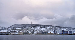
Harstad is the second largest city and municipality by population, in Troms county, Norway – the city is also the third largest in North Norway.[2][3] Thus Harstad is the natural centre for its district. Situated approximately 250 kilometres (155 mi) north of the Arctic Circle, the city celebrated its 100th anniversary in 2004.
Contents |
Geography
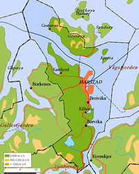
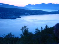
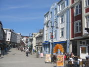
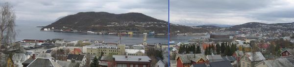
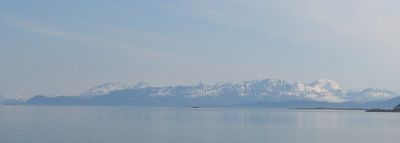
The municipality is located on two islands in south Troms. Most of the municipality is located on Hinnøya, which is Norway's largest coastal island (three islands in the Svalbard archipelago are larger). The northern part of the municipality is located on the southern half, 53 square kilometres (20 sq mi), of Grytøya. Harstad is bordered by the municipality of Bjarkøy to the north, Kvæfjord to the west, and Tjeldsund (in the county of Nordland) to the south. To the southeast the Tjeldsund Bridge connects Hinnøya with Skånland and the mainland across Tjeldsundet, and to the northeast is the Vågsfjorden, where Harstad shares a water border with Ibestad. The city itself is located northeast on Hinnøya; it is the only city on the island, and is popularly known as Vågsfjordens perle (The pearl of Vågsfjorden).
The municipality contains several small islands, including Arnøya, Gressholman, Kjeøya, Kjøtta, Kjøttakalven, Måga, Rogla, Lille Rogla and Åkerøya.
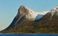
The highest mountain is Sætertinden, which is 1,095 m (3,593 ft) above sea level.[4] It is located near Sandtorg, Hinnøya. The 412-metre (1,352 ft) tall mountain, Nupen, is located in the northwestern part of the municipality on the border with Kvæfjord.
The oil industry of North Norway is centered in Harstad, but the city also has shipyards and other industries that are important for the economy. Harstad and the surrounding area have traditionally been among the most productive agricultural regions in North Norway, with the old seabed creating fertile soil that is well-suited for farming.
Climate and light
Despite being located north of the Arctic Circle, Harstad incredibly features a subpolar oceanic climate with relatively mild winters and cool summers. This has long been thought to be due to the relatively warm Gulf Stream, but northern Europe's mild climate has been shown to be due to intercontinental weather patterns driven by North America's mountain ranges.[5] Harstad does not have the brutal winters that most locations north of the Arctic Circle experiences. The city actually experiences warmer winters than major cities located 25 to 30 degrees farther south in latitude in the northern hemisphere such as Beijing, Chicago and Toronto. Summers in Harstad are cool, with average high temperatures seldom breaking the 22 °C (72 °F) mark. Mean annual temperature is 3.9 °C (39.0 °F) (1961–90) and annual average precipitation is 850 millimetres (33.5 in).[6] With high pressure weather, winter temperatures can get down to about −15 °C (5 °F), and in summer reach 27 °C (81 °F). [7]
The city enjoys the midnight sun during the summer months, from 22 May to 18 July. There is also a period with twilight a few hours each night as the sun just dips below the horizon, so there is no darkness from early May to early August. The polar night, when the sun is always below the horizon, lasts from 30 November to 12 January. At this time, there are a few hours with dusk/dawn around noon, sometimes with colorful skies towards the south. From late January, day length rapidly increases, reaching 12 hours by March and 18 hours in April. Harstad is located in the midst of the aurora borealis (a.k.a. the northern lights) zone, and the aurora can often be seen on clear nights, but not in summer due to the continuous daylight.
| Climate data for Harstad (10 last years) | |||||||||||||
|---|---|---|---|---|---|---|---|---|---|---|---|---|---|
| Month | Jan | Feb | Mar | Apr | May | Jun | Jul | Aug | Sep | Oct | Nov | Dec | Year |
| Source: [8] | |||||||||||||
History
The town of Harstad was established as a municipality on 1 January 1904 when it was separated from the municipality of Trondenes. The initial population of Harstad was 1,246. On 1 January 1964, the municipalities of Sandtorg, Trondenes, and Harstad were merged together to form a a new, combined municipality with a population of 17,882. Prior to the merger, Harstad had 3,808 residents.[9]
In recent years, a 3000-year-old bronze axe[10] and a 2600-year-old bronze collar[11] have been found at the Trondenes peninsula, just north of the city center. These, together with the burial cairns built close to the sea, are indications of a well developed Bronze Age culture in the Harstad area.
There is also substantial archeological evidence of a well developed Iron Age culture in the area, around 200 AD.
Trondenes is mentioned in the Heimskringla as a power centre in the Viking Age and a place to meet and discuss important issues (Trondarting).
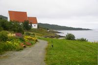
Trondenes Church, the world's northernmost medieval church, which dates back to the 13th–15th century, is situated just outside the town.
Adjacent to the church is the Trondenes Historical Center and nearby is the Adolf Gun, an enormous land-based cannon from World War II, and the last of four cannons originally constructed by the Nazis. Harstad is one of the few towns in this part of Norway which were left largely undamaged by World War II.
Origin of the name
The city is most likely named after the old Harstad farm (Old Norse: Harðarstaðir), since it is built on its ground. The first element is (probably) the genitive case of the male name Hörðr, and the last element is staðir which means "homestead" or "farm".[12]
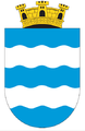
Coat-of-arms
The coat-of-arms is from modern times. They were granted on 24 April 1953. The blue symbolizes the sea with silvery/white waves.[13]
Institutions and culture
The city hosts the annual week long Festival of North Norway.[14]
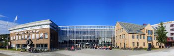
Harstad University College, with approximately 1,100 students,[15] has a thriving foreign exchange program with students from all over the world. The hospital in Harstad is part of the University Hospital of North Norway.
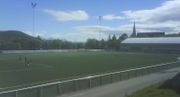
The most successful local football team is Harstad Idrettslag (a.k.a. HIL),[16] and the most successful basketball team is the Harstad Vikings.[17]
Harstad is home port for the Anna Rogde, the world's oldest sailing schooner, also known as the sailing queen of Norway.[18]
Harstad Camping is a campsite located in the municipality.
Military connections
Harstad traditionally has strong ties with the Norwegian Armed Forces. Kystjegerkommandoen (Coastal Ranger Command) has its home base at Trondenes, Harstad. Marinejegerkommandoen is based in Ramsund in Tjeldsund on the mainland south of Harstad. General Carl Gustav Fleischer led the field operations of the Norwegian Armed Forces in WW2, among them the 7,500 soldiers which from the north pushed the Nazi Germans back to Narvik and participated in retaking Narvik on 28 May 1940. A street in Harstad is named Gen. Fleischers Gate in his honour.
Transportation
The closest airport is Harstad/Narvik Airport, Evenes, located on the mainland, 45 kilometres (28 mi) by road from the city center.
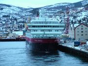
Every morning a northbound and a southbound Coastal Express ship stop in Harstad.[19]
Express boats regularly go between Harstad and Tromsø, Finnsnes, Senja, and other places.[20]
There are several ferries[21] and buses[22] in the district.
In Harstad there are local buses.[23]
The leading helicopter company in Northern Norway, Heli-Team, is located in Harstad.[24]
Local areas

| Villages north/west of the city | ||
|---|---|---|
| Grøtavær | Lundenes | Alvestad |
| Kjøtta | Kasfjord | Aune |
| Stornes | Årnes | Røkenes |
| Undlandet | Ervik | Vika |
| Mustaparta | Hagan | Kilhus |
| Tennvassåsen | Tømmeråsen | Steinnes |
| Storvassbotn | Sørlia | |
| City neighbourhoods | ||
| Bergseng | Trondenes | Sama |
| Blåbærhaugen | Harstadåsen | Eineberget |
| Skaret | City Center | Heggen |
| Seljestad | Harstadbotn | Grønnebakkan |
| Gangsås | Stangnes | Åsby |
| Kanebogen | Medkila | Holtet |
| Breivik | Ruggevik | Kilbotn |
| Villages south of the city | ||
| Nordvik | Melvik | Sørvik |
| Halsebø | Brokvik | Fauskevåg |
| Gausvik | Haukebø | Sandtorg |
Notable residents
- Knut Andersen (1931–), director
- Bjarne Berg-Sæther (1919–), mayor, county mayor, parliament politician
- Trygve Bornø (1942–), former national football player
- Kristin Clemet (1957–), politician, former minister of education
- Hans Egede (1686–1758), priest
- Karl Erik Harr (1940–), painter, anthropologist
- Kine Hellebust (1954–), singer
- Leif Arne Heløe (1932–), minister of social affairs
- Jon Lech Johansen (1983–), hacker
- Hanna Kvanmo (1926–2005), politician
- Runar Normann (1978–), football player
- Iren Reppen (1965–), actress, playwright
- Iselin Steiro (1985–), supermodel
- Ketil Stokkan (1956–), singer
- Even Kenneth Weines (1980–), country singer
- Unni Wikan (1944–), professor of social
- Ørjan Steiro Mortensen (1988-), musician
International relations
Twin towns — Sister cities
The twin towns of Harstad are:[25]
See also
- List of schools in Harstad
References
- ↑ "Personnemningar til stadnamn i Noreg" (in Norwegian). Språkrådet. http://www.sprakrad.no/Sprakhjelp/Rettskriving_Ordboeker/Innbyggjarnamn.
- ↑ Municipality second largest in Troms county
- ↑ City second largest in Troms county; third largest in North Norway
- ↑ "Sætertinden". http://www.westcoastpeaks.com/Peaks/saetertinden.html.
- ↑ "The source of Europe's mild climate". http://www.americanscientist.org/issues/feature/2006/4/the-source-of-europes-mild-climate/1.
- ↑ Harstad climate statistics 1961-90
- ↑ "yr.no:Harstad statistics for last 12 months". http://www.yr.no/place/Norway/Troms/Harstad/Harstad~541704/statistics.html.
- ↑ "Harstad average conditions - base period 10 last years". Storm Weather Center. http://www.storm.no/vaer/harstad/klima. Retrieved 26 November 2009.
- ↑ Jukvam, Dag (1999). "Historisk oversikt over endringer i kommune- og fylkesinndelingen" (in Norwegian). Statistisk sentralbyrå. http://www.ssb.no/emner/00/90/rapp_9913/rapp_9913.pdf.
- ↑ "Bronze axe". http://www.aftenposten.no/english/local/article382361.ece.
- ↑ "Bronze collar". http://www.archaeology.org/0109/newsbriefs/horseshoe.html.
- ↑ Rygh, Oluf (1911) (in Norwegian). Norske gaardnavne: Troms amt (17 ed.). Kristiania, Norge: W. C. Fabritius & sønners bogtrikkeri. pp. 21. http://www.dokpro.uio.no/perl/navnegransking/rygh_ng/rygh_bla.prl?enhid=270481&avid=59936&s=n.
- ↑ "Harstad kommunes byvåpen" (in Norwegian). Harstad kommune. http://www.harstad.kommune.no/internett/index.asp?startID=&topExpand=&subExpand=&strUrl=//applications/system/publish/view/showobject.asp?infoobjectid=1002818&menuid=1001364. Retrieved 2008-12-02.
- ↑ "Festspillene i Nord-Norge". http://www.festspillnn.no/default.asp?cmd=600.
- ↑ "Harstad University College". http://www.hih.no/Internasjonale_programmer/infoenglish/default.asp.
- ↑ "HIL" (in Norwegian). http://www.harstad-idrettslag.no.
- ↑ "Harstad Vikings" (in Norwegian). http://www.mjodberget.net.
- ↑ "Anna Rogde" (in Norwegian). http://www.annarogde.no/default.asp?cmd=210.
- ↑ "Coastal Express". http://www.hurtigruten.com/en/default.aspx?side_id=551.
- ↑ "Express boats". http://www.hurtigruten.com/en/default.aspx?side_id=533.
- ↑ "Ferries". http://www.hurtigruten.com/en/default.aspx?side_id=429.
- ↑ "Buses". http://www.hurtigruten.com/en/default.aspx?side_id=420.
- ↑ "Local buses". http://www.veolia-transport.no/tmpl/ExtensionPage____33301.aspx?epslanguage=ML.
- ↑ "Helicopter". http://www.heliteam.no/Index.asp?Command=200&ID=1&Language=E.
- ↑ "Twin towns". http://www.harstad.kommune.no. Choose English > Political info > Friendship cities
External links
- Harstad travel guide from Wikitravel
- Information in English Harstad municipality
- Visit Harstad
- Culture
- Old history of Harstad
- Harstad pictures
- Green and black aurora over Harstad NASA astronomy picture of the day
- Particularly rare purple auroral corona over Harstad NASA astronomy picture of the day
- Web-cam Showing various parts of the town
- Photo presentation on YouTube
- The Adolf Cannon
- Art of the States: Frozen Horizon Musical work inspired by the Harstad landscape
- Harstad Tidende (Harstad Times) Newspaper for the district (Norwegian)
- iHarstad.no Information portal (Norwegian)
- Live weather station located in Harstad (Norwegian)
- About Hinnøy (Norwegian)
- Magnars garden at 69 degrees north (Norwegian)
|
|||||||
|
||||||||||||||||||||||||||||||||||||||||||||||||||||||||||||||||||||||||||||||||||||||||||