Imphal
|
||||||||||||||||||||||||||||||||||||||||||||||||||||||||||||||||||||||||||||||||||||||||||||||||||||||||||||||||||||||||||||
|
||||||||||||||||||||||||||||||||||||||||||||||||||||||||||||||||||||||||||||||||||||||||||||||||||||||||||||||||||||||||||||

Imphal pronunciation is the capital of the Indian state of Manipur.
In the heart of the town and surrounded by a moat, are ruins of the old Palace of Kangla. Kangla Fort use to be the home of the Assam Rifles, a paramilitary force and on November 2004 it was handed over to state of Manipur by Prime minister Dr. Manmohan Singh. Another place of historical interest is the Polo Ground which is the oldest existing polo ground in the world. Near the Polo Ground is the Manipur State Museum, which has a collection of old artifacts and pictures depicting the history of Manipur. 'Ima Keithel' at Khwairamband Bazar is the only market in the world where, as the name suggests, all the stalls are run by women.charu
In 1944 during World War II the Battle of Imphal, along with the simultaneous Battle of Kohima, was the turning point in the Burma Campaign. For the first time in the South-East Asian Theatre of World War II the Japanese lost the initiative to the Allies, who retained it until the end of the war.
The state is also famous for the Brow-antlered Deer called the Sangai. This species of the deer is endemic to Manipur and is on the verge of extinction. Last count of Sangai deer revealed only 162 left in the Keibul Lamjao National Park.
On 18 June 1997, the Imphal district was split into Imphal East and Imphal West.
On 21 October 2008, Imphal was struck by a large scale terror attack allegedly carried out by Myanmar based Manipuri insurgents seeking independence from India.
Contents |
Geography and climate
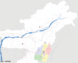
Imphal is the capital of Manipur, located at .[1] It has an average elevation of 786 metres (2578 feet). It is located in the extreme east of India.
The Imphal Valley is drained by several small rivers originating from the hills surrounding it. These include the Imphal, Iril, Sekmai, Thoubal, and Khuga rivers. One of the important place is Wangkhei, where one can see the Temple of Govinda Jee with nature's beauty and also Wangkhei locality is famous for Handloom Products and Hand Made Products.
Imphal has a sub-tropical climate, specifically a humid subtropical climate, with cool, dry winters, a warm summer and a moderate monsoon season. July is the hottest month with temperatures averaging around 25oC (78oF), while January is the coldest with average lows near 4oC (40oF). The city gets about 1320 mm (52 inches) of rain with June being the wettest month.
Main tourist attractions of Imphal
Shree Govindajee Temple
This place was considered to be the highest place for any cultural activity during the times of the Maharajas. Located at a place near the Royal palace of past Maharajas, it has two domes and a raise congregation hall to keep the sacred deities in their place, aloof and high.
War Cemeteries
The cemeteries are the seats of remembrance for the British and Indian soldiers who fought and died in the Second World War. When you visit these cemeteries, the peace and the cleanliness of the place will entice you. If the tourists are not satisfied with the serenity then they can go through the various written messages on the stone markers and bronze plaques of the graves.
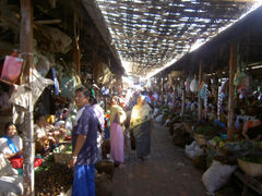
Women's Market or Ima Keithel
Cacophony, bargain of products and a spread of a beautiful and colourful cloth is what you would most notice when you visit this market place. But, this is the charm of the place, if a person wants to know how the trade goes in Manipur, this is the first place to buy. The bazar consist of two main sections -one where the vegetables, fruits and necessary items are sold and the other where the handloom products of the state is sold. The peculiarity of the market is that around 3000 'Imas' or mothers run the stalls.
Manipur Zoological Gardens
The Brow Antlered deer, which is a rare species, can be seen in the Manipur Zoological Gardens. Located at a distance of 6 km from the capital, the zoo is very modest to the core with its surrounding, a large expanse of open grounds.
Manipur State Museum
The museum, which is the representation of the tangible information of history, shows a display of the tribal heritage and the collection of the artifacts of the former Ningthourels of Manipur. Costumes of the common people and warriors, arms and weapons of the varied communities and relics and historical documents can be seen here. The priceless artifacts, documents and cultural heritage of a mentioned civilization can be first accessed through a Museum.
Transport
Air
Daily flights are available from New Delhi to Imphal via Guwahati, capital of Assam. Daily flights also connect Imphal with Kolkata.
Railways
In 2007, the Economist newspaper reported that a railway line from Guwahati via Imphal to Moreh, the last frontier town less than a km. from the border of Myanmar would be built.
Demographics
As of 2001[update] India census,[2] Imphal had a population of 217,275. Males constitute 50% of the population and females 50%. Imphal has an average literacy rate of 79%, higher than the national average of 59.5%: male literacy is 84%, and female literacy is 74%. In Imphal, 10% of the population is under 6 years of age.
References
- ↑ Falling Rain Genomics, Inc - Imphal
- ↑ "Census of India 2001: Data from the 2001 Census, including cities, villages and towns (Provisional)". Census Commission of India. Archived from the original on 2004-06-16. http://web.archive.org/web/20040616075334/http://www.censusindia.net/results/town.php?stad=A&state5=999. Retrieved 2008-11-01.
External links
|
|||||
|
|||||