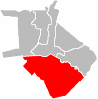
Intramuros
| Intramuros | |
|---|---|
| Nickname(s): The Walled City | |
 |
|
| Country | Philippines |
| Region | National Capital Region |
| City | Manila |
| Congressional districts | Part of the 5th district of Manila |
| Barangays | 5 |
| Area | |
| - Total | 0.67 km2 (0.26 sq mi) |
| Population (2007[1]) | |
| - Total | 5,015 |
| - Density | 7,485.1/km2 (19,386.3/sq mi) |
Intramuros, located along the southern bank of the Pasig River, was built by the Spaniards in the 16th century and is the oldest district of the city of Manila, the capital of the Philippines. Its name, in Latin, intramuros, literally "within the walls", meaning within the wall enclosure of the city/fortress, also describes its structure as it is surrounded by thick, high walls and moats. During the Spanish colonial period, Intramuros was considered Manila itself.
Contents |
History
Pre-hispanic settlement
The site of Intramuros was originally a large Indianized-Malayan-Islamic settlement named "Maynila", ruled by Datus, Rajahs and a Sultan. The name came from "may nila", "nila" being a water plant (Scyphiphora hydrophyllacea) whose star-shaped flowers clustered in abundance along the riverbanks. "May-nila," transliterates as "There is nila (here)". Maynila is also sometimes called Maynilad because nila is popularly referred to as nilad by people unfamiliar with the plant, a correction asserted by historians Ambeth Ocampo and Carmen Guerrero Nakpil.[2]
The strategic location of Maynila, being on the Pasig River and the Manila Bay, made it an ideal location for indigenous Tagalog and kapampangan tribes to trade with other Asian civilizations, including Chinese, Indian and Islamic merchants who had come from China, India, Borneo and Indonesia. Maynila was also the seat of power for native chiefs who ruled the area before Europeans first arrived in Luzon.
Spanish colonial period
In 1564, Spanish explorers led by Miguel López de Legazpi sailed from Mexico, and arrived on the island of Cebu in February 13, 1565. There they established the first Spanish colony in the Islands. Having heard of the rich resources of Manila by natives, López de Legazpi dispatched two of his Lieutenant-commanders, Martín de Goiti and Juan de Salcedo to explore the northern regions of the Visayas.
In 1570, the Spaniards arrived in the island of Luzon. After quarrels and misunderstanding had erupted between the Islamic natives and the Spaniards, both groups fought for the control of lands and settlements. In 1571, after several months of warfare, the natives were defeated, and the Spaniards made a peace pact with the Muslim tribal councils, Rajah Sulaiman III, Rajah Lakandula, and Rajah Matanda; who, in return, handed over Manila to the Spaniards.
Citing the rich resources and location of Manila, López de Legazpi declared the area as the new capital of the Spanish colony in the Philippines on June 24, 1571. The King of Spain, delighted at the new conquest achieved by López de Legazpi and his men, awarded the city a coat of arms and declaring it Ciudad Insigne y Siempre Leal ("Distinguished and ever loyal city").
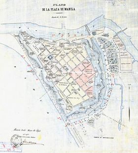
The planning of the city of Manila was commenced by López de Legazpi who had become the first Governor general on the islands. He established forts, roads, churches and schools. The plans for Intramuros were based on King Philip II of Spain's Royal Ordinance issued on July 3, 1573 in San Lorenzo, Spain. Its design was based upon a star fort or trace italienne (a very flat structure composed of many triangular bastions, specifically designed to cover each other, and a ditch) and covered 64 hectares of land, surrounded by 8 feet thick stones and high walls that rise 22 feet. It was built to protect the seat of the Spanish government from hostile native revolts, and raiding Chinese sea pirates.
Intramuros was completed in 1606 and it served as the center of political, military and religious power of the Spaniards during the time that the Philippines was a colony of Spain. Inside Intramuros; there are several Roman Catholic churches, like the Manila Cathedral and the San Agustin Church, convents and church-run schools, such as the Universidad de Santo Tomás, the Colegio de San Juan de Letrán and the Ateneo Municipal de Manila, which were usually being run by religious orders such as the Dominicans, Augustinians, Franciscans and Jesuits. The Governor's Palace, the official residence of the Spanish Viceroyalties to the Philippines was originally in Intramuros before it was officially moved to Malacañang Palace and Fort Santiago. Only Spaniards and mestizos were allowed to take part on political issues and take residence inside the walled city. Christian natives and Chinese were allowed to enter, but Spanish officials prevented them from living inside. The vast majority of the natives and Chinese residents lived outside the walled city.
Barangays
| Name | Population (2007)[1] |
|---|---|
| Barangay 654 | 864 |
| Barangay 655 | 1,787 |
| Barangay 656 | 424 |
| Barangay 657 | 420 |
| Barangay 658 | 1,520 |
Original building structures
Note: parenthesis () indicates the new buildings that occupy the same site today.
Churches
- Lourdes Church (El Almanecer)
- Manila Cathedral*
- San Agustin Church*
- Santo Domingo Church (Bank of the Philippine Islands)
- San Francisco Church (Mapúa Institute of Technology)
- San Ignacio Church* (Ruins)
- San Nicolas de Tolentino Church (Manila Bulletin)
- Beaterio de la Compañia de Jesus* (Light and Sound Museum)
- Convento de Sta. Clara (Empty Lot)
- Chapel of the Third Venerable Order (Mapúa Chapel)
Schools
- Ateneo Municipal de Manila (Clamshell 1)
- Beaterio-Colegio de Sta. Catalina (Letran Elementary School)
- Colegio de San Juan de Letrán*
- Colegio de Sta. Isabel (Clamshell 2)
- Colegio de Sta. Rosa*
- (Manila High School*)
- Mapúa Institute of Technology
- (Pamantasan ng Lungsod ng Maynila)
- Lyceum of the Philippines University
- University of Santo Tomas (BF Condominiums) - Bound by Plaza Santo Tomas and Ayuntamiento (ruins)
- Universidad Maximo de San Ignacio (Pamantasan ng Lungsod ng Maynila)
Other buildings
- Palacio del Gobernador* (Commission on Elections)
- Audiencia (former Supreme Court building and the Old Commission on Elections*)[3] (Ruins)
- Ayuntamiento* (Ruins)
- Hospital de San Juan de Dios (Lyceum of the Philippines University)
- Intendencia* (Ruins)
- Palacio Arzobispal*
- Palacio de Sta. Potenciana (Philippine Red Cross)
World War II
At the end of World War II, much of Intramuros was damaged by the returning joint American and Filipino military forces.
In 1942, when the Japanese forces invaded the Philippines; U.S. forces led by General Douglas McArthur realized that Manila was indefensible so he declared it an Open City. He regrouped the USAFFE forces in the Bataan peninsula, only to be trapped there by the advancing Japanese army.
Upon their return in February 23, 1945, United States forces, including Philippine Commonwealth troops, shelled Manila, including Intramuros, to flush out the remaining 400 or so Japanese soldiers, in the process of the shelling 100,000 citizens of Manila died (see Manila Massacre). Intramuros was in ruins following the fighting, and the only structure that survived was the San Agustin Church; almost no other buildings remained standing.
Present day Intramuros
In the 1980s, under the direction of former Philippine First Lady Imelda Marcos, the Intramuros Administration restored the city and at present the walled city is the only district of Manila where old Spanish-era influences were retained. Much of the development of present-day Manila occurred outside the gates of Intramuros, leaving the surviving walls, streets and churches of Intramuros minimally touched by modernization, although outlets of Jollibee, McDonald's and Starbucks now sit alongside distinguished educational institutions within its walls. The old moats that surrounded Intramuros have been filled up and transformed into a golf course where locals and foreign nationals play the sport. The garrison that was Fort Santiago is now a tourist spot where visitors can enjoy the nostalgic romance of a bygone Spanish legacy within its gardens. In 2003, during Visit Philippines Year, Tourism Secretary Richard J. Gordon cleaned up Intramuros with the help of student and civilian volunteers as well as raised funds to light up the place and build a lights and sound museum.
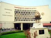
Intramuros now houses some of the higher education institutions in the Philippines. These are the city-owned Pamantasan ng Lungsod ng Maynila, the technical school Mapúa Institute of Technology, Lyceum of the Philippines University, Colegio de San Juan de Letran and high schools such as the Manila High School,and Colegio de Santa Rosa.
Following the design of medieval fortifications, along the massive walls of Intramuros are strategically located bulwarks: baluarte, ravelins: ravellin, redoubts: reducto. Entrance to the city are through gates: puerta, most of which have been restored or rebuilt. Most of these features have names such as Baluarte de San Diego, Baluarte de San Francisco de Dilao, Baluarte de San Gabriel, Baluarte de Sta. Barbara, Baluarte de San Andres; Puerta Real, Puerta Isabel II, Puerta del Parian, Puerta Almacenes, Postigo del Palacio, Puerta Sta. Lucia.
Preserving Intramuros' Heritage
In her article "Intramuros, Manila" (Inquirer.net), Rose Beatrix C. Angeles writes about the need to preserve national heritage that is Intramuros
Below is a direct quotation from the author's article:
Square foot for square foot, no other site in the country holds as much national historical interest as Intramuros. Even its very ground is unique as it holds artifacts that recount the ages of trade even prior to Spanish conquest. Every single conqueror of this country flew its flag over the Intramuros, and all – except the Americans – retreated to the safety behind its walls prior to ejection.
The oldest fortified city in the country needs help. It needs increased funding to provide, among others, more restored sites, an appropriate museum for the Intramuros Administration’s collection, removal of informal settlers, further archeological assessment and so on ad nauseam.
The IA has been doing a valiant job despite its myriad internal problems but much of its work had been delayed by lack of funds and political will, just like nearly every other government agency. The last thing it needs is to keep fending off covetous government officials whose minds are far, very far, from heritage''.[4]
Source: Rose Beatrix C. Angeles, "Intramuros, Manila", INQUIRER.net 07/09/2008 Intramuros Manila
Intramuros gallery
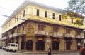
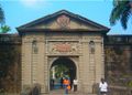 Puerta del Parian |
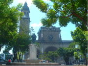 Manila Cathedral |
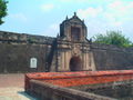 Fort Santiago |
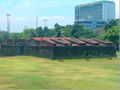 Reducto de San Pedro |
 Plaza de la Fuerza |
 Casa Manila |
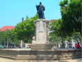 Plaza de Roma, with the statue of King Carlos IV of Spain |
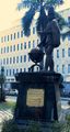 Statue of Philip II of Spain in Intramuros |
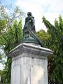 A statue of Queen Isabela II at the entrance of Puerta Isabela II |
References
- ↑ 1.0 1.1 Final Results - 2007 Census of Population
- ↑ Ambeth Ocampo (June 25, 2008), Looking Back: Pre-Spanish Manila, Philippine Daily Inquirer, http://services.inquirer.net/print/print.php?article_id=20080625-144587, retrieved 2008-09-09
- ↑ Fire razes old COMELEC Building
- ↑ "Intramuros, Manila" by Rose Beatrix C. Angeles, Inquirer.net 07/09/2008
External links
- Philippine Convention and Visitors Corporation Intramuros Map - dead link
- Department of Tourism's WOWPhilippines Intramuros Virtual Map - dead link
- Fort Santiago Panoramic View
- Intramuros Travel Guide from Wikitravel.
|
|||||||||||||||||||||