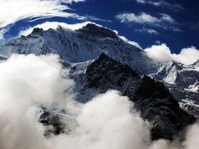
Jungfrau
| Jungfrau | |
|---|---|
 Northern wall |
|
| Elevation | 4,158 m (13,642 ft) |
| Prominence | 704 m (2,310 ft) |
| Location | |
 Jungfrau
|
|
| Range | Bernese Alps |
| Topo map | Swisstopo 1249 Finsteraarhorn |
| Climbing | |
| First ascent | August 3, 1811 by J. Meyer, H. Meyer, A. Volker, J. Bortis |
| Easiest route | basic snow/ice climb |
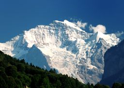
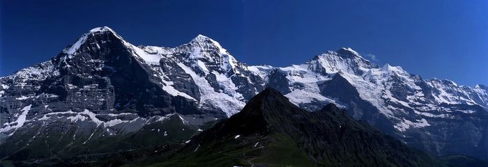
The Jungfrau (German: "maiden/virgin") is one of the main summits in the Bernese Alps, situated between the cantons of Valais and Bern in Switzerland. Together with the Eiger and Mönch, the Jungfrau forms a massive wall overlooking the Bernese Oberland and considered one of the most emblematic sights of the Swiss Alps.
The summit was first reached on August 3, 1811 by the Meyer brothers of Aarau and two chamois hunter from Valais. The ascent followed a long expedition over the glaciers and high passes of the Bernese Alps. It was not until 1865 that a more direct route on the northern side was opened.
The construction of the Jungfraujoch railway east to the summit in the early 20th century made the area one of the most frequented places in the Alps. Along with the Aletsch Glacier lying on the south, the Jungfrau is part of the Jungfrau-Aletsch Protected Area which was declared a World Heritage site in 2001.
Contents |
Geographic setting
The Jungfrau is the third highest mountain of the Bernese Alps after the nearby Finsteraarhorn and Aletschhorn, respectively 12 and 8 km away.[1] But from Lake Thun, and the greater part of the canton of Berne, it is the most conspicuous and the nearest of the Oberland peaks, while its extreme steepness when viewed from that side secured for it, as the name suggests, an early reputation for inaccessibility.
The Jungfrau is the westernmost and highest point of a gigantic 10 km wall dominating the valleys of Lauterbrunnen and Grindelwald. The wall is formed by the alignment of some of the most distinctive north faces in the Alps, with the Mönch (4,107 m) and Eiger (3,970 m) alongside the Jungfrau, and overlooks the valleys to its north by a height of up to 3 km. Jungfrau is approximately 6 km from the Eiger; with the summit of the Mönch lying roughly in the middle, 3.5 km from the Jungfrau. The wall is extended to the east by the Fiescherwand and to the west by the Lauterbrunnen Wall.
The difference of altitude between the deep valley of Lauterbrunnen (800 m) and the summit is particularly visible from the area of Mürren. From the valley floor, west of the massif, the altitude gain is more than 3 km for a horizontal distance of 4 km.
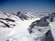
The landscapes around the Jungfrau are extremely contrasted. Instead of the vertiginous precipices of the north-west, the south-east side emerges from the upper snows of the Aletsch Glacier at around 3,500 metres. The 20 km long valley of Aletsch on the south-east is completely uninhabited and also surrounded by other similar glacier valleys. The whole area constitutes the largest glaciated area in the Alps as well as in Europe.[2]
Climbing history
In 1811, the brothers Johann Rudolf (1768-1825) and Hieronymus Meyer, sons of Johann Rudolf Meyer (1739-1813), the head of a rich merchant family of Aarau, with several servants and a porter picked up at Guttannen, having reached the Valais by way of the Grimsel, crossed the Beich Pass, a glacier pass over the Oberaletsch Glacier, to the head of the Lötschen valley. There they added two local chamois hunters, Alois Volker and Joseph Bortis, to their party and traversed the Lötschenlücke before reaching the Aletschfirn (the west branch of the Aletsch Glacier), where they established the base camp, north of the Aletschhorn. After the Guttannen porter was sent back alone over the Lötschenlücke, the party finally reached the summit of the Jungfrau by the Rottalsattel on August 3. They then recrossed the two passes named to their point of departure in Valais, and went home again over the Grimsel.[3][4]
The journey was a most extraordinary one for the time, and some persons threw doubts on its complete success. To settle these another expedition was undertaken in 1812. In this the two sons, Rudolf (1791-1833) and Gottlieb (1793-1829), of Johann Rudolf Meyer, played the chief parts. After an unsuccessful attempt, defeated by bad weather, in the course of which the Oberaarjoch was crossed twice (this route being much more direct than the long detour through the Lötschental), Rudolf, with the two Valais hunters (Alois Volker and Joseph Bortis), a Guttannen porter named Arnold Abbühl, and a Hasle man, bivouacked on a depression on the southeast ridge of the Finsteraarhorn. Next day (August 16) the whole party attempted the ascent of the Finsteraarhorn from the Studer névé on the east by way of the southeast ridge, but Meyer, exhausted, remained behind. The following day the party crossed the Grünhornlücke to the Aletsch Glacier, but bad weather then put an end to further projects. At a bivouac, probably just opposite the present Konkordia Hut, the rest of the party, having come over the Oberaarjoch and the Grünhornlücke, joined the Finsteraarhorn party. Gottlieb, Rudolf's younger brother, had more patience than the rest and remained longer at the huts near the Märjelensee, where the adventurers had taken refuge. He could make the second ascent (September 3) of the Jungfrau, the Rottalsattel being reached from the east side as is now usual, and his companions being the two Valais hunters. [4]
The third ascent dates from 1828, when several men from Grindelwald, headed by Peter Baumann, planted their flag upon the summit. Next came the ascent by Louis Agassiz, James David Forbes, Heath, Desor, and Duchatelier in 1841, recounted by Desor in his Excursions et Séjours dans les Glaciers. Gottlieb Samuel Studer published an account of the next ascent made by himself and Bürki in 1842. In 1863, a party consisting of John Tyndall, J. J. Hornby, and T. H. Philpott, successfully reached the summit and returned to the base camp of the Faulberg (located near the actual position of the the Konkordia Hut) in less than 11 hours.[5]
Before the construction of the Jungfraujoch railway tunnel, the approach from the glaciers on the south side was very long. The first direct route from the valley of Lauterbrunnen was opened in 1865 by Geoffrey Winthrop Young, H. Brooke George with the guide Christian Almer. They had to carry ladders with them in order to cross the many crevasses on the north flank. Having passed the night on the rocks of the Schneehorn (3,402 m) they gained next morning the Silberlücke, the depression between the Jungfrau and Silberhorn, and thence in little more than 3 hours reached the summit. Descending to the Aletsch Glacier they crossed the Mönchsjoch, and passed a second night on the rocks, reaching Grindelwald next day. This route became a usual until the opening of the Jungfraujoch.[3][6]
The first winter ascent was made on 23 January 1874, by Meta Brevoort and W. A. B. Coolidge with guides Christian and Ulrich Almer.[7] They used a sled to reach the upper Aletsch Glacier. Miss Brevoort's favorite dog, Tschingel, accompanied them to the top.[3]
The Jungfrau was climbed via the west side for the first time in 1885 by Fritz and Heinrich von Almen, Ulrich Brunner, Fritz Graf, Karl Schlunegger and Johann Stäger. They ascended the Rottal ridge (Innere Rottalgrat) and reached the summit on 21 September. The even more difficult and dangerous northeast ridge that connects the summit from the Jungfraujoch was first climbed on 30 July 1911 by Albert Weber and Hans Schlunegger.[8]
In July 2007 six Swiss Army recruits, part of the Mountain Specialists Division 1, died in an accident on the normal route. Although the causes of the deaths was not immediately clear, a report by the Swiss Federal Institute for Snow and Avalanche Research concluded that the avalanche risk was unusually high due to recent snowfall, and that there was "no other reasonable explanation" other than an avalanche for the incident.[9]
Jungfraujoch and tourism
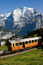
Once difficult to access, the Jungfraubahn cog railway now runs inside the mountain, up to the Jungfraujoch railway station at 3,454 m (11,332 ft), the highest in Europe. The Jungfraujoch is the lowest pass between the Jungfrau and Mönch.
The idea of a railway tunnel to the Jungfraujoch to make the glaciated areas on the south more accessible came into the mind of Adolf Guyer-Zeller in 1893. But the building of the tunnel took 16 years and the summit station was not opened before 1912. The goal was in fact to reach the summit of the Jungfrau with an elevator from the highest railway station inside the mountain. The complete project was not realized because of the outbreak of the World War I.[3]
The train into the mountain leaves from Kleine Scheidegg, which can be reached by trains from Grindelwald and Lauterbrunnen. The train enters the tunnel running eastward through the Eiger shortly after leaving Kleine Scheidegg. Before arriving at the Jungfraujoch, it stops for a few minutes at two other stations, Eigerwand (on the north face of the Eiger) and Eismeer (on the south side), where the traveller can have a look through the excavated holes. The journey from Kleine Scheidegg to Jungfraujoch takes approximately 50 minutes including the stops; the downhill return journey taking only 35 minutes.
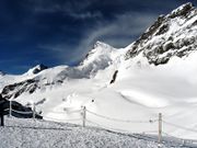
A large complex of tunnels and buildings has been constructed at the Jungfraujoch, mostly into the south side of the Mönch. There is a hotel, two restaurants, an observatory, a research station, a small cinema, a ski school, and the "Ice Palace", a collection of elaborate ice sculptures. Another tunnel leads outside to a flat, snow-covered area, where one can walk around and look down to the Konkordiaplatz and the Aletsch Glacier, as well as the surrounding mountains.
Apart from the Jungfraujoch, many facilities have been built in the two valleys north of the Jungfrau (the commonly named Jungfrau Region). In 1908, the first public cable car opened at the foot of the Wetterhorn, but was closed 7 years later.[10] The Schilthorn above Mürren or the Männlichen above Wengen offer good views of the Jungfrau and other summits.
Climbing routes
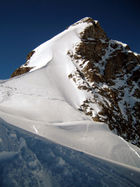
The normal route follows the traces of the first climbers, but the long approach on the Aletsch Glacier is no longer necessary. From the area of the Jungfraujoch the route to the summit takes only a few hours. Most climbers starts from the Mönchsjoch Hut. After a traverse of the Jungfraufirn the route heads to the Rottalsattel (3,885 m), from where the southern ridge leads to the Jungfrau. It is not considered a very difficult climb but it can be dangerous on the upper section above the Rottalsattel, where most of the accidents happen.[3] The use of the Jungfrau railway can cause some acclimatization troubles as the difference of altitude between the railway stations of Interlaken and Jungfraujoch is almost 3 km.
The final section of the climb is accomplished along one of the longest and sharpest arêtes of frozen snow to be found in the Alps, beyond which the eye plunges abruptly down a precipice 3.000 ft. in height into the depths of the Rottal, on the west of the Jungfrau. With perfect steadiness and first-rate guides there is no danger, unless too early in the season, or soon after a heavy fall of fresh snow. When it is necessary to cut steps all the way in hard frozen névé, the work is very laborious, and 3 hours may be consumed in ascending the 725 ft. that separate the Sattel from the summit. Some rocks jut out close to the top, but the actual peak consists of a nearly level ridge of frozen snow falling away on either side like a house-top with an excessively steep roof. The view, on one side, commands the icy plains of the Aletsch Glacier, and the highest alpine peaks far and near; on the other overlooks populous valleys that lie at a depth of 2 miles below the spectator's feet.[11]
References
- ↑ Swisstopo maps
- ↑ Jungfrau-Aletsch unesco.org. Retrieved 2010-02-08
- ↑ 3.0 3.1 3.2 3.3 3.4 Helmut Dumler,Willi P. Burkhardt, Les 4000 des Alpes, ISBN 2-7003-1305-4
- ↑ 4.0 4.1 W. A. B. Coolidge, The Alps in Nature and History, p. 216, 1908
- ↑ John Ball, The Alpine Guide: Central Alps, 1869, p. 92
- ↑ John Ball, The Alpine Guide: Central Alps, 1869, p. 74
- ↑ Guide des Alpes bernoises, Swiss Alpine Club
- ↑ Guide des Alpes bernoises, Swiss Alpine Club
- ↑ Questions remain a year after Jungfrau tragedy swissinfo.ch, retrieved 18 May 2009
- ↑ Berner Oberland strollingguides.co.uk, retrieved 1 May 2009
- ↑ John Ball, The Alpine Guide: Central Alps, 1869, p. 92
External links
- "Jungfrau". SummitPost.org. http://www.summitpost.org/show/mountain_link.pl/mountain_id/150315/mountain.html.
- Jungfraujoch Top of Europe
- Live Webcam at Jungfraujoch Top of Europe
- Photo Eiger Mönch and Jungfrau
- Photo Jungfrau from Kleine Scheidegg
- 3D Photosynth from Harder Kulm (requires Silverlight)
|
||||||||||||||||