K2
|
||||||||||||||||||||||||
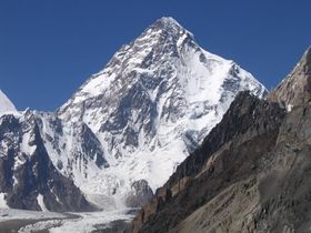
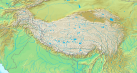
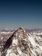
K2 is the second-highest mountain on Earth after Mount Everest. With a peak elevation of 8,611 metres (28,251 ft), K2 is part of the Karakoram Range, and is located on the border[2] between the Taxkorgan Tajik Autonomous County of Xinjiang, China, and Gilgit, in Gilgit-Baltistan of Pakistan.[3][note]
K2 is known as the Savage Mountain due to the difficulty of ascent and the 2nd highest fatality rate among the 'eight thousanders' for those who climb it. For every four people who have reached the summit, one has died trying.[4] Unlike Annapurna, the mountain with the highest fatality rate, K2 has never been climbed in winter.
Contents |
Name
The name K2 is derived from the notation used by the Great Trigonometric Survey. Thomas Montgomerie made the first survey of the Karakoram from Mount Haramukh, some 130 miles (210 km) to the south, and sketched the two most prominent peaks, labelling them K1 and K2.[5]
The policy of the Great Trigonometric Survey was to use local names for mountains wherever possible[6] and K1 was found to be known locally as Masherbrum. K2, however, appeared not to have acquired a local name, possibly due to its remoteness. The mountain is not visible from Askole, the last village to the south, or from the nearest habitation to the north, and is only fleetingly glimpsed from the end of the Baltoro Glacier, beyond which few local people would have ventured.[7] The name Chogori, derived from two Balti words, chhogo ('big') and ri ('mountain') (شاہگوری) has been suggested as a local name, but evidence for its widespread use is scant. It may have been a compound name invented by Western explorers[8] or simply a bemused reply to the question "What's that called?"[7] It does, however, form the basis for the name Qogir (simplified Chinese: 乔戈里峰; traditional Chinese: 喬戈里峰; pinyin: Qiáogēlǐ Fēng) by which Chinese authorities officially refer to the peak. Other local names have been suggested including Lamba Pahar ("Tall Mountain" in Urdu) and Dapsang, but are not widely used.[7]
Lacking a local name, the name Mount Godwin-Austen was suggested, in honour of Henry Godwin-Austen, an early explorer of the area, and while the name was rejected by the Royal Geographical Society[7] it was used on several maps, and continues to be used occasionally.[9][10]
The surveyor's mark, K2, therefore continues to be the name by which the mountain is commonly known. It is now also used in the Balti language, rendered as Kechu or Ketu[8][11] (Urdu: کے ٹو). The Italian climber Fosco Maraini argued in his account of the ascent of Gasherbrum IV that while the name of K2 owes its origin to chance, its clipped, impersonal nature is highly appropriate for so remote and challenging a mountain. He concluded that it was...
"...just the bare bones of a name, all rock and ice and storm and abyss. It makes no attempt to sound human. It is atoms and stars. It has the nakedness of the world before the first man - or of the cindered planet after the last."[12]
Climbing history
Early attempts

The mountain was first surveyed by a European survey team in 1856. Thomas Montgomerie was the member of the team who designated it "K2" for being the second peak of the Karakoram range. The other peaks were originally named K1, K3, K4 and K5, but were eventually renamed Masherbrum, Broad Peak, Gasherbrum II and Gasherbrum I respectively. In 1892, Martin Conway led a British expedition that reached 'Concordia' on the Baltoro Glacier.[13]
The first serious attempt to climb K2 was undertaken in 1902 by Oscar Eckenstein and Aleister Crowley, via the Northeast Ridge. In those days, the modern transportation that we take for granted did not exist: It took "fourteen days just to reach the foot of the mountain". [14] After five serious and costly attempts, the team reached 6,525 metres (21,407 ft) [15] - although considering the difficulty of the challenge, and the lack of modern climbing equipment or weatherproof fabrics, Crowley's statement that "neither man nor beast was injured" highlights the pioneering spirit and bravery of the attempt. The failures were also attributed to sickness (Crowley was suffering the residual effects of malaria), a combination of questionable physical training, personality conflicts, and poor weather conditions — of 68 days spent on K2 (at the time, the record for the longest time spent at such an altitude) only eight provided clear weather.[16]
The next expedition to K2 in 1909, led by Luigi Amedeo, Duke of the Abruzzi, reached an elevation of around 6,250 metres (20,505 ft) on the South East Spur, now known as the Abruzzi Spur (or Abruzzi Ridge). This would eventually become part of the standard route, but was abandoned at the time due to its steepness and difficulty. After trying and failing to find a feasible alternative route on the West Ridge or the North East Ridge, the Duke declared that K2 would never be climbed, and the team switched its attention to Chogolisa, where the Duke came within 150 metres (492 ft) of the summit before being driven back by a storm.[17]
The next attempt on K2 was not made until 1938, when an American expedition led by Charles Houston made a reconnaissance of the mountain. They concluded that the Abruzzi Spur was the most practical route, and reached a height of around 8,000 metres (26,247 ft) before turning back due to diminishing supplies and the threat of bad weather.[18][19] The following year an expedition led by Fritz Wiessner came within 200 metres (656 ft) of the summit, but ended in disaster when Dudley Wolfe, Pasang Kikuli, Pasang Kitar and Pintso disappeared high on the mountain.[20][21]
Charles Houston returned to K2 to lead the 1953 American expedition. The expedition failed due to a storm which pinned the team down for ten days at 7,800 metres (25,591 ft), during which time Art Gilkey became critically ill. A desperate retreat followed, during which Pete Schoening saved almost the entire team during a mass fall, and Gilkey was killed, either in an avalanche or in a deliberate attempt to avoid burdening his companions. In spite of the failure and tragedy, the courage shown by the team has given the expedition iconic status in mountaineering history.[22][23][24]
Success and repeats
An Italian expedition finally succeeded in ascending to the summit of K2 on July 31, 1954. The expedition was led by Ardito Desio, although the two climbers who actually reached the top were Lino Lacedelli and Achille Compagnoni. The team included a Pakistani member, Colonel Muhammad Ata-ullah, who had been a part of the 1953 American expedition. Also on the expedition were the famous Italian climber Walter Bonatti and Pakistani Hunza porter Mahdi, who proved vital to the expedition's success in that they carried oxygen to 26,600 feet (8,100 m) for Lacedelli and Compagnoni. Their dramatic bivouac in the open at that altitude wrote another chapter in the saga of Himalayan climbing.
On August 9, 1977, 23 years after the Italian expedition, Ichiro Yoshizawa led the second successful ascent to the top; with Ashraf Aman as the first native Pakistani climber. The Japanese expedition ascended through the Abruzzi Spur route traced by the Italians, and used more than 1,500 porters to achieve the goal.
The year 1978 saw the third ascent of K2, via a new route, the long, corniced Northeast Ridge. (The top of the route traversed left across the East Face to avoid a vertical headwall and joined the uppermost part of the Abruzzi route.) This ascent was made by an American team, led by noted mountaineer James Whittaker; the summit party were Louis Reichardt, Jim Wickwire, John Roskelley, and Rick Ridgeway. Wickwire endured an overnight bivouac about 150 metres (492 ft) below the summit, one of the highest bivouacs in climbing history. This ascent was emotional for the American team, as they saw themselves as completing a task that had been begun by the 1938 team forty years earlier.[25]
Another notable Japanese ascent was that of the difficult North Ridge, on the Chinese side of the peak, in 1982. A team from the Mountaineering Association of Japan led by Isao Shinkai and Masatsugo Konishi put three members, Naoe Sakashita, Hiroshi Yoshino, and Yukihiro Yanagisawa, on the summit on August 14. However Yanagisawa fell and died on the descent. Four other members of the team achieved the summit the next day.[26]
The first climber to summit K2 twice was Czech climber Josef Rakoncaj. Rakoncaj was a member of the 1983 Italian expedition led by Francesco Santon, which made the second successful ascent of the North Ridge (July 31, 1983). Three years later, on July 5, 1986, he summitted on the Abruzzi Spur (double with Broad Peak West Face solo) as a member of Agostino da Polenza's international expedition.
Recent attempts
The peak has now been climbed by almost all of its ridges. Although the summit of Everest is at a higher altitude, K2 is a much more difficult and dangerous climb, due in part to its more inclement weather and comparatively greater height from base to peak. The mountain is believed by many to be the world's most difficult and dangerous climb, hence its nickname "the Savage Mountain." It, and the surrounding peaks, have claimed more lives than any others.[27] As of July 2010, only 302 people have completed the ascent,[28] compared with over 2,700 individuals who have ascended the more popular target of Everest. At least 77 people have died attempting the climb. Notably, 13 climbers from several expeditions died in 1986 in the 1986 K2 Disaster, five of these in a severe storm. More recently, on August 1, 2008, a group of climbers went missing after a large piece of ice fell during an avalanche taking out the fixed ropes on part of the route; four climbers were rescued, but 11, including Gerard McDonnell, the first Irish person to reach the summit, were confirmed dead.[29] On 6 August 2010, Fredrik Ericsson, who intended to ski from the summit, joined Gerlinde Kaltenbrunner on the way to the summit of K2. Ericsson fell 1,000 metres (3,300 ft) and was killed. Kaltenbrunner aborted her summit attempt.[30]
The use of bottled oxygen
For most of its climbing history, K2 was not usually climbed with bottled oxygen, and small, relatively lightweight teams were the norm.[31][32] However the 2004 season saw a great increase in the use of oxygen: 28 of 47 summiteers used oxygen in that year.[33]
Acclimatisation is essential when climbing without oxygen to avoid some degree of altitude sickness.[34] K2's summit is well above the altitude at which high altitude pulmonary edema (HAPE), or high altitude cerebral edema (HACE) can occur.[35]
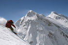
Climbing routes and difficulties
There are a number of routes on K2, of somewhat different character, but they all share some key difficulties. First, of course, is the extreme high altitude and resulting lack of oxygen: there is only one-third as much oxygen available to a climber on the summit of K2 as there is at sea level.[36] Second is the propensity of the mountain to experience extreme storms of several days' duration, which have resulted in many of the deaths on the peak. Third is the steep, exposed, and committing nature of all routes on the mountain, which makes retreat more difficult, especially during a storm. Despite many tries there has been no successful ascent during the winter. All major climbing routes lie on the Pakistani side, which is also where the base camp is located.
Abruzzi Spur
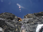
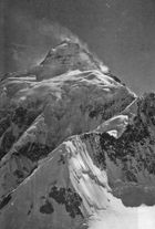
The standard route of ascent, used far more than any other route, is the Abruzzi Spur,[31][32] located on the Pakistani side, first attempted by Luigi Amedeo, Duke of the Abruzzi in 1909. This is the southeast ridge of the peak, rising above the Godwin Austen Glacier. The spur proper begins at an altitude of 5,400 m/17,700 ft, where Advanced Base Camp is usually placed. The route follows an alternating series of rock ribs, snow/ice fields, and some technical rock climbing on two famous features, "House's Chimney" and the "Black Pyramid." Above the Black Pyramid, dangerously exposed and difficult to navigate slopes lead to the easily visible "Shoulder", and thence to the summit. The last major obstacle is a narrow couloir known as the "Bottleneck", which places climbers dangerously close to a wall of seracs which form an ice cliff to the east of the summit. It was partly due to the collapse of one of these seracs around 2001 that no climbers summitted the peak in 2002 and 2003.[33]
On August 1, 2008, a number of climbers went missing when a serac in the Bottleneck snapped and broke their ropes.[37][38] Survivors were seen from a helicopter but rescue efforts were impeded by the high altitude. Eleven were never found, and presumed dead.[29]
North Ridge
Almost opposite from the Abruzzi Spur is the North Ridge,[31][32] which ascends the Chinese side of the peak. It is rarely climbed, partly due to very difficult access, involving crossing the Shaksgam River, which is a hazardous undertaking.[39] In contrast to the crowds of climbers and trekkers at the Abruzzi basecamp, usually at most two teams are encamped below the North Ridge. This route, more technically difficult than the Abruzzi, ascends a long, steep, primarily rock ridge to high on the mountain (Camp IV, the "Eagle's Nest", 7,900 m/25,900 ft), and then crosses a dangerously slide-prone hanging glacier by a leftward climbing traverse, to reach a snow couloir which accesses the summit.
Besides the original Japanese ascent, a notable ascent of the North Ridge was the one in 1990 by Greg Child, Greg Mortimer, and Steve Swenson, which was done alpine style above Camp 2, though using some fixed ropes already put in place by a Japanese team.[39]
Other routes
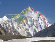
- Northeast Ridge (long and corniced; finishes on uppermost part of Abruzzi route), 1978.
- West Ridge, 1981.
- Southwest Pillar or "Magic Line", very technical, and second most demanding. First climbed in 1986 by the Polish-Slovak trio Piasecki-Wróż-Božik. Since then the Catalan Jordi Corominas was the only successful climber on this route, despite many other attempts.
- South Face or "Polish Line" (extremely exposed and most dangerous). In 1986, Jerzy Kukuczka and Tadeusz Piotrowski summitted on this route. Reinhold Messner called it a suicidal route and no one has repeated their achievement. "The route is so avalanche-prone, that no one else has ever considered a new attempt."[40]
- Northwest Face, 1990.
- Northwest Ridge (finishing on North Ridge). First ascent in 1991.
- South-southeast spur or "Cesen route" (finishing on Abruzzi route. A possibly safer alternative to the Abruzzi Spur because of avoiding the first big obstacle on Abruzzi called Black Pyramid ), 1994.
- West Face (technically difficult at high altitude), done by a Russian team in 2007 Official site.
Topographic characteristics
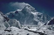
K2 is only ranked 22nd by topographic prominence, a measure of a mountain's independent stature, because it is part of the same extended area of uplift (including the Karakoram, the Tibetan Plateau, and the Himalaya) as Mount Everest, in that it is possible to follow a path from K2 to Everest that goes no lower than 4,594 m (15,072 ft) (at Mustang Lo). Many other peaks which are far lower than K2 are more independent in this sense.
However, K2 is notable for its local relief as well as its total height. It stands over 3,000 metres (9,843 ft) above much of the glacial valley bottoms at its base. More extraordinary is the fact that it is a consistently steep pyramid, dropping quickly in almost all directions. The north side is the steepest: there it rises over 3,200 metres (10,499 ft) above the K2 (Qogir) Glacier in only 3,000 metres (9,843 ft) of horizontal distance. In most directions, it achieves over 2,800 metres (9,186 ft) of vertical relief in less than 4,000 metres (13,123 ft).[41]
In the media
Books on K2
(Expeditions listed as per Curran. Not all varieties as per Yakushi listed. (Catalogue of the Himalayan Literature, Ed. by Yoshimi Yakushi, 1994 edition). Foreign language editions only listed when no English one is available. ISBN omitted as they serve no purpose at all. Far from complete, but working on it!)
1887 - ![]() British - Younghusband
British - Younghusband
- Francis Younghusband, The Heart of a Continent, 1896, (Yakushi Y27)
1892 - ![]() British - Conway
British - Conway
- Martin Conway, Climbing and Exploration in the Karakoram Himalayas, 1894, (Yakushi C336a)
- Oscar Eckenstein, The Karakorams and Kashmir Himalayas, 1896, (Yakushi E10)
1902 - International - Eckenstein and Crowley
- Aleister Crowley, The Confessions of Aleister Crowley, 1969, (not in Yakushi)
- Dr Jules Jacot-Guillarmod, Six Mois dans l'Himalaya, le Karakorum et l'Hindu-Kush., 1904, (Yakushi J17), (
 edition only)
1909 - ![]() Italian - Luigi Amedeo
Italian - Luigi Amedeo
- Filippo de Filippi, La spedizione nel Karakoram e nell'Imalaia occidentale, 1912, (Yakushi F71a), (
 edition)
 - Filippo de Filippi, Karakorum and Western Himalaya, 1912, (Yakushi F71b), (
 / (
/ ( edition)
 - Mirella Tenderini and Michael Shandrick, The Duke of Abruzzi: An Explorer's Life, 1977, (not in Yakushi)
1929 - ![]() Italian - Aimone di Savoia-Aosta
Italian - Aimone di Savoia-Aosta
- Aimone di Savoia-Aosta and Ardito Desio, La Spedizione Geografica Italiana al Karakoram, 1936, (Yakushi S670), ( edition only)
1937 - ![]() British - Shipton
British - Shipton
- Eric Shipton, Blank on the map, 1938, (Yakushi S432)
1938 - ![]() American - Houston
American - Houston
- Charles Houston and Bob Bates, Five Miles High, 1939, (Yakushi B165)
1939 - ![]() American - Wiessner
American - Wiessner
- Jennifer Jordan, Last Man on the Mountain, 2010, (not in Yakushi)
- Andrew Kauffman and William Putnam, K2; The 1939 Tragedy, 1992, (Yakushi K66)
- Fritz Wiessner, K2, Tragödien und Sieg am Zweithöchsten Berg der Erde, 1955, (Yakushi W152), (
 edition only)
1953 - ![]() American - Houston
American - Houston
- Charles Houston and Bob Bates, K2, The Savage Mountain, 1954, (Yakushi H429a)
- Charles Houston, Bob Bates and George Bell, K2, 8611m, 1954, (Yakushi H430), ( edition only)
1954 - ![]() Italian - Desio
Italian - Desio
- Mohammad Ata-Ullah, Citizen of Two Worlds, 1960, (Yakushi A284)
- Walter Bonatti, The Mountains of My Life, 2001, (not in Yakushi)
- Walter Bonatti, Processo al K2, 1985, (Yakushi B453), ( edition)
- Walter Bonatti, K2. La verità. 1954-2004, 2005, (not in Yakushi), ( edition)
- Achille Compagnoni, Uomini sul K2, 1958, (Yakushi C328), ( edition only)
- Achille Compagnoni, Tricolore sul K2, 1965, (Yakushi C329), ( edition only)
- Achille Compagnoni, K2: conquista italiana tra storia e memoria, 2004, (not in Yakushi), ( edition only)
- Ardito Desio, Ascent of K2. Second Highest Peak in the World, 1955, (Yakushi D167b), ( edition)
- Ardito Desio, Libro Bianco, 1956, (Yakushi D168), ( edition only)
- Mario Fantin, Sogno Visuto, 1958, (Yakushi F10), ( edition only)
- Lino Lacedelli and Giovanni Cenacchi, K2: The Price of Conquest, 2006, (not in Yakushi), ( edition)
- Robert Marshall, K2. Lies and Treachery, 2009, (not in Yakushi)
1975 - ![]() American - Whittaker
American - Whittaker
- Galen Rowell, In the Throne Room of the Mountain Gods, 1977, (Yakushi R366)
1978 - ![]() American - Whittaker
American - Whittaker
- Cherie Bremer-Kamp / Cherie Bech, Living on the Edge, 1987, (Yakushi B558)
- Rick Ridgeway, The Last Step: The American Ascent of K2, 1980, (Yakushi R216)
1979 - ![]() French - Mellet
French - Mellet
- Bernard Mellet, K2. La victoire suspendu, 1980, (Yakushi M307), ( edition only)
1979 - International - Messner
- Reinhold Messner and Alessandro Gogna, K2, Mountain of Mountains, 1981, (Yakushi M340c), ( edition)
1986 - (Expeditions momentarily lumped together for convenience sake.)
- John Barry, K2, Savage Mountain, Savage Summer, 1987, (Yakushi B135)
- Benoît Chamoux, Le Vertige de l'Infinie, 1988, (Yakushi C125), ( edition only)
- Jim Curran, K2, Triumph and Tragedy., 1987, (Yakushi C405a)
- Anna Czerwińska, Groza wokół K2, 1990, (Yakushi C420), (
 edition only)
 - Kurt Diemberger, The Endless Knot: K2, Mountain of Dreams and Destiny, 1991, (Yakushi D234d), ( edition)
1993 - ![]() American /
American / ![]() Canadian - Allison
Canadian - Allison
- Jim Haberl, K2, Dreams and Reality, 1994, (not in Yakushi)
2008 - (Expeditions momentarily lumped together for convenience sake.)
- Graham Bowley, No way down - Life and death on K2, 2010, (not in Yakushi)
- Marco Confortola, Giorni di ghiaccio. Agosto 2008. La tragedia del K2, 2009, (not in Yakushi), ( edition)
General literature on K2
- Fulvio Campiotti, K2, 1954, (Yakushi C36), ( edition only)
- Jim Curran, K2, The Story of the Savage Mountain, 1995, (not in Yakushi)
- Kurt Diemberger and Roberto Mantovani, K2. Challenging the sky, 1995, (not in Yakushi)
- Heidi Howkins, K2: One Woman's Quest for the Summit, 2001, (not in Yakushi)
- Maurice Isserman and Stewart Weaver, Fallen Giants: A History of Himalayan Mountaineering from the Age of Empire to the Age of Extremes, 2008, (not in Yakushi)
- Dušan Jelinčič, Zvezdnate noči (Starry Nights), 2006, (not in Yakushi)
- Jennifer Jordan, Savage Summit: The True Stories of the First Five Women Who Climbed K2, 2005, (not in Yakushi)
- Jon Krakauer, Eiger Dreams: Ventures Among Men and Mountains, 1997, (not in Yakushi)
- Kenneth Mason, Abode of Snow, 1955, (Yakushi M214a), ( edition)
- Bernadette McDonald, Brotherhood of the Rope: The biography of Charles Houston, 2007, (not in Yakushi)
- Reinhold Messner, K2 Chogori. La grande montagna, 2004, (not in Yakushi), ( edition)
- Greg Mortenson and David Oliver Relin, Three Cups of Tea: One Man's Mission to Promote Peace . . . One School at a Time, 2007, (not in Yakushi)
- Mustansar Hussain Tarrad, K2 Kahani, (in Urdu), 2002, (not in Yakushi)
- Ed Viesturs, No Shortcuts to the Top: Climbing the World's 14 Highest Peaks, 2007, (not in Yakushi)
- Ed Viesturs, K2: Life and Death on the World's Most Dangerous Mountain, Aug 2010, (not in Yakushi)
Films
- Vertical Limit, 2000
- K2, 1992
- Karakoram & Himalayas, 2007
CDs
- In 1988, the British rock musician Don Airey released the album K2 (Tales of Triumph and Tragedy) (feat. Gary Moore and Colin Blunstone), which was dedicated to the 13 K2-victims in 1986.
- Hans Zimmer created a score for the movie K2. This score was unused in the film: the soundtrack was released separately in 1992 as K2: Music Inspired By The Film
See also
- 1986 K2 disaster
- 2008 K2 disaster
- Concordia
- Gilgit-Baltistan
- List of mountains in Pakistan
- List of the highest mountains in the world
- List of peaks by prominence
- List of deaths on eight-thousanders
- Hassan sadpara
References and notes
- ↑ Northern Pakistan Places, Photos, 750+ Placemarks! - Google Earth Community
- ↑ Text of border agreement between China and Pakistan
- ↑ "K2". Britannica.com. http://www.britannica.com/EBchecked/topic/309107/K2. Retrieved 2010-01-23.
- ↑ "K2 list of ascents and fatalities" (PDF). 8000ers.com. http://www.8000ers.com/cms/download.html?func=startdown&id=161. Retrieved 2010-01-23.
- ↑ Curran, Jim (1995). K2: The Story of the Savage Mountain. Hodder & Stoughton. p. 25. ISBN 978-0340660072.
- ↑ The most obvious exception to this policy was Mount Everest, where the local name Chomolungma was probably known, but ignored in order to pay tribute to George Everest. See Curran, p. 29-30.
- ↑ 7.0 7.1 7.2 7.3 Curran, p. 30
- ↑ 8.0 8.1 H. Adams Carter, "A Note on the Chinese Name for K2, 'Qogir'", American Alpine Journal, 1983, p. 296. Carter, the long-time editor of the AAJ, goes on to say that the name Chogori "has no local usage. The mountain was not prominently visible from places where local inhabitants ventured and so had no local name.... The Baltis use no other name for the peak than K2, which they pronounce 'Ketu'. I strongly recommend against the use of the name Chogori in any of its forms."
- ↑ Pakistan entry at The World Factbook
- ↑ H. Adams Carter, "Balti Place Names in the Karakoram", American Alpine Journal, 1975, p. 52–53. Carter notes that "Godwin Austen is the name of the glacier at its eastern foot and is only incorrectly used on some maps as the name of the mountain."
- ↑ Carter, op cit. Carter notes a generalisation of the word Ketu: "A new word, ketu, meaning 'big peak', seems to be entering the Balti language."
- ↑ Maraini, Fosco (1961). Karakoram: the ascent of Gasherbrum IV. Hutchinson. Quoted in Curran , p. 31.
- ↑ Charles S. Houston (1953) K2, the Savage Mountain. McGraw-Hill.
- ↑ [1] "Confessions of Aleister Crowley, Chapter 16"
- ↑ A timeline of human activity on K2
- ↑ Booth, Martin (2001) [2000]. "Rhythms of Rapture" (trade paperback). A Magick Life: A Biography of Aleister Crowley (Coronet ed.). London: Hodder and Stoughton. pp. 152–157. ISBN 0-340-71806-4.
- ↑ Curran, Jim (1995). K2: The Story of the Savage Mountain. Hodder & Stoughton. pp. 65–72. ISBN 978-0340660072.
- ↑ Houston, Charles S; Bates, Robert (1939). Five Miles High. Dodd, Mead. ISBN 978-1585740512. Reprinted (2000) by First Lyon Press with introduction by Jim Wickwire
- ↑ Curran, pp.73-80
- ↑ Kaufman, Andrew J.; Putnam, William L. (1992). K2: The 1939 Tragedy. Mountaineers Books. ISBN 978-0898863239.
- ↑ Curran pp.81-94
- ↑ Houston, Charles S; Bates, Robert (1954). K2 - The Savage Mountain. Mc-Graw-Hill Book Company Inc. ISBN 978-1585740130. Reprinted (2000) by First Lyon Press with introduction by Jim Wickwire
- ↑ McDonald, Bernadette (2007). Brotherhood of the Rope - The Biography of Charles Houston. The Mountaineers Books. pp. 119–140. ISBN 978-0898869422.
- ↑ Curran, Jim (1995). K2: The Story of the Savage Mountain. Hodder & Stoughton. pp. 95–103. ISBN 978-0340660072.
- ↑ American Alpine Journal, 1979, pp. 1–18
- ↑ American Alpine Journal, 1983, p. 295
- ↑ BBC, Planet Earth, "Mountains", Part Three
- ↑ "Climber Lists: Everest, K2 and other 8000ers". http://www.viewfinderpanoramas.org/climbers.html.
- ↑ 29.0 29.1 "Climber: 11 killed after avalanche on Pakistan's K2". CNN. August 3, 2008. http://www.cnn.com/2008/WORLD/asiapcf/08/03/pakistan.climbers/index.html. Retrieved May 7, 2010.
- ↑ [2]
- ↑ 31.0 31.1 31.2 Andy Fanshawe and Stephen Venables, Himalaya Alpine-Style, Hodder and Stoughton, 1995, ISBN 0-340-64931-3
- ↑ 32.0 32.1 32.2 Audrey Salkeld, editor, World Mountaineering, Bulfinch Press, 1998, ISBN 0-8212-2502-2
- ↑ 33.0 33.1 American Alpine Journal, 2005, p. 351–353
- ↑ Muza, SR; Fulco, CS; Cymerman, A (2004). "Altitude Acclimatisation Guide.". US Army Research Inst. of Environmental Medicine Thermal and Mountain Medicine Division Technical Report (USARIEM-TN-04-05). http://archive.rubicon-foundation.org/7616. Retrieved 2009-03-05.
- ↑ Cymerman, A; Rock, PB. Medical Problems in High Mountain Environments. A Handbook for Medical Officers. USARIEM-TN94-2. US Army Research Inst. of Environmental Medicine Thermal and Mountain Medicine Division Technical Report. http://archive.rubicon-foundation.org/7976. Retrieved 2009-03-05.
- ↑ Altitude oxygen calculator online
- ↑ "Climber: 11 killed after avalanche on Pakistan's K2 - CNN.com". CNN. August 3, 2008. http://www.cnn.com/2008/WORLD/asiapcf/08/03/pakistan.climbers/index.html?iref=mpstoryview. Retrieved May 7, 2010.
- ↑ "Nine feared dead in K2 avalanche". BBC. August 3, 2008. http://news.bbc.co.uk/1/hi/world/south_asia/7539543.stm. Retrieved 2008-08-03.
- ↑ 39.0 39.1 American Alpine Journal, 1991, pp. 19–32
- ↑ R. Messner and A. Gogna [1981] (1982) K2 Mountain of Mountains. Translated from German by A. Salked. Oxford University Press. ISBN 0195202538
- ↑ Jerzy Wala, The Eight-Thousand-Metre Peaks of the Karakoram, Orographical Sketch Map, The Climbing Company Ltd/Cordee, 1994.
^ The Government of India also claims K2 to be in its territory, as part of its territorial dispute on Pakistan-administered Kashmir.
External links
- Blankonthemap The Northern Kashmir WebSite
- How high is K2 really? – Measurements in 1996 gave 8614.27±0.6 m a.m.s.l
- Aleister Crowley's account of the 1902 expedition
- K2climb.net
- CNR meteo station
- The Mountain Areas Conservancy Project
- The climbing history of K2 from the first attempt in 1902 until the Italian success in 1954.
- Outside Online: The K2 Tragedy
- K2: Daring to Dream Documentary
- Sample of K2 poster product including Routes and NotesPDF (235 KB) From Everest-K2 Posters
- Northern Pakistan - highly detailed placemarks of towns, villages, peaks, glaciers, rivers and minor tributaries in Google Earth
- "K2". SummitPost.org. http://www.summitpost.org/show/mountain_link.pl/mountain_id/150257/mountain.html.
- "K2" Encyclopædia Britannica
- Map of K2
- List of ascents to December 2007 (in pdf format)
- 'K2: The Killing Peak' Men's Journal November 2008 feature
- Achille Compagnoni - Daily Telegraph obituary
- Dr Charles Houston - Daily Telegraph obituary
|
|||||
|
|||||||||||||||||||||||