Kalgoorlie
| Kalgoorlie-Boulder Western Australia |
|||||||
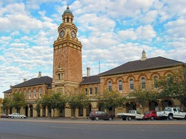 Kalgoorlie Post Office, Hannan Street |
|||||||
 Kalgoorlie-Boulder
|
|||||||
| Population: | 28,242 (2006 census)[1] (42nd) | ||||||
| • Density: | 273.9/km² (709.4/sq mi) | ||||||
| Established: | 1893 | ||||||
| Elevation: | 468 m (1,535 ft) | ||||||
| Area: | 103.1 km² (39.8 sq mi) | ||||||
| Time zone: | AWST (UTC+8) | ||||||
| Location: | 595 km (370 mi) E of Perth | ||||||
| LGA: | City of Kalgoorlie-Boulder | ||||||
| State District: | Kalgoorlie, Eyre | ||||||
| Federal Division: | O'Connor | ||||||
|
|||||||
Kalgoorlie, known as Kalgoorlie-Boulder, is a city in the Goldfields-Esperance region of Western Australia, and is located 595 kilometres (370 mi) east-northeast of state capital Perth at the end of the Great Eastern Highway. The city was founded in 1893 during the Yilgarn-Goldfields gold rush, and is located close to the so-called "Golden Mile".
It has a population of 28,246,[1] making it the largest urban centre in the Goldfields-Esperance region and the fifth-largest in Western Australia.
The name Kalgoorlie is derived from the Wangai word Karlkurla, meaning "place of the silky pears".
Contents |
History
In January 1893, prospectors Patrick (Paddy) Hannan, Tom Flanagan, and Dan O'Shea were travelling to Mount Youle when one of their horses cast a shoe. During the halt in their journey, the men noticed signs of gold in the area, and decided to stay put. On 17 June 1893, Hannan filed a Reward Claim, leading to hundreds of men swarming to the area in search of gold and Kalgoorlie, originally called Hannan's, was born.[2]
The mining of gold, along with other metals such as nickel, has been a major industry in Kalgoorlie ever since, and today employs about one-quarter of Kalgoorlie's workforce and generates a significant proportion of its income. The concentrated area of large gold mines surrounding the original Hannan find is often referred to as the Golden Mile, and is considered by some to be the richest square mile of earth on the planet. The town's population was about 30,000 people in 1903 and began to grow into nearby Boulder.
The narrow gauge Government railway line reached Kalgoorlie in 1896, and the main named railway service from Perth was the overnight sleeper train The Westland which ran until the 1970s. In 1917, a standard gauge railway line was completed, connecting Kalgoorlie to the city of Port Augusta, South Australia across 2,000 kilometres (1,243 mi) of desert, and consequently the rest of the eastern states. The standardisation of the railway connecting Perth (which changed route from the narrow gauge route) in 1968 completed the Sydney-Perth railway, making it possible for rail travel from Perth to Sydney—and the Indian Pacific rail service commenced soon after. During the 1890s, the Goldfields area boomed as a whole, with an area population exceeding 200,000, mainly prospectors. The area gained a notorious reputation for being a wild west with bandits and prostitutes. This rapid increase in population led to a proposed new state of Auralia but with the sudden diaspora after the Gold Rush led to plans falling through.
Places, famous or infamous, that Kalgoorlie is noted for include its water pipeline, designed by C. Y. O'Connor, which brings in fresh water from Mundaring Weir near Perth; its Hay Street brothels (the street itself was apparently named after Hay Street, Perth); its two-up school; the goldfields railway loopline; the Kalgoorlie Town Hall; the Paddy Hannan statue/drinking fountain; the Super Pit; and Mount Charlotte lookout. Its main street is Hannan Street, named after the town's founder. One of the infamous brothels also serves as a museum and is a major national attraction.
Kalgoorlie and the surrounding district was serviced by an extensive collection of suburban railways and tramways, providing for both passenger and freight traffic.[3]
Mining
Since 1992, Kalgoorlie is home to the Diggers & Dealers conference, held annually in August. It is Australia's premier international mining conference.[4]
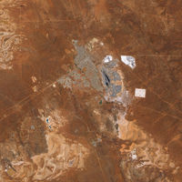
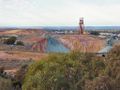
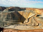
The Super Pit
The Super Pit is an open-cut gold mine approximately 3.6 kilometres (2.2 mi) long, 1.6 kilometres (1.0 mi) wide and 512 metres (1,680 ft) deep.[5] It was created by Alan Bond, who bought up a number of old mine leases in order to get the land area needed for the Super Pit. Every now and again the digging reveals an old shaft containing abandoned equipment and vehicles from the earlier mines.
The mine operates 24 hours a day, 7 days a week, and a visitor centre overlooks it. The mine blasts at 1:00 pm every day, unless winds would carry dust over the town. Each of the massive trucks carries 225 tonnes of rock and the round trip takes about 35 minutes, most of that time being the slow uphill haul. Employees must live in Kalgoorlie; it is not a fly-in fly-out operation. The mine is expected to be productive until about 2017. At that point, it is planned to abandon it and allow the groundwater to seep in and fill it. It is estimated it will take about 50 years to fill completely full.
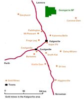 Gold mines in the Kalgoorlie region. |
 The pit that gives the mine its name appears in the centre of this image. |
Attractions
Accommodation
There are 25 historical hotels and pubs in Kalgoorlie which are still operating today;
- Albion Shamrock Hotel
- Broken Hill Hotel
- Caledonia House
- Cornwall Hotel
- Criterion Hotel
- de Bernales Tavern (formerly Victoria Tavern)
- Exchange Hotel
- Flanagans Bar (formerly Union Club Hotel)
- Gala Tavern
- Grand Hotel (Kalgoorlie)
- Grand Hotel (Boulder)
- Hannans Hotel
- Inland City Hotel
- Kalgoorlie Hotel
- Main Reef Tavern
- Metropole Hotel
- North End Tavern
- Palace Hotel
- Piccadilly Hotel
- Recreation Hotel
- Rock Inn (formerly Tattersalls)
- Star and Garter
- Tower Hotel
- York Hotel
There are also some hotels that no longer exist in the city;
- Boulder Block (demolished 1991) (Removed due to Super Pit expansion. This pub had a mine shaft so underground workers could access it.)
- Eastern Hotel (formerly Federal Hotel)
- Commercial Hotel (burnt down 3 November 1978)[6]
- Foundry Hotel (closed 2005- Damaged by fire 3 July 2008, deliberately lit on fire in 2009)
- Glendevon Hotel (burnt down 1986)
- Mount Lyall (refurbished as restaurant 2004)
- Oriental Hotel (demolished July 1972)[7]
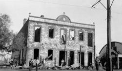
- Golden Eagle [The collapsed balcony of the Golden Eagle hotel on the corner of Lane and Wittenoom St in Boulder.Proof.
In addition, Kalgoorlie has modern accommodation facilities, including;
- The View On Hannans (Formerly The Hannans View Motel)[8]
- Rydges Hotel
- Railway Hotel/Motel
- Quest Yelverton Apartments
- All Seasons Plaza Hotel
- Bel Eyre Motel
- Kalgoorlie Overland Motel
- Midas Motel
And Previously
- Old Australia Hotel (now part of Curtin University of Technology as Student Accommodation)
Suburbs
The Kalgoorlie-Boulder metropolitan area consists of a number of suburbs
- Boulder
Known as the home of the Super Pit, it is one of Kalgoorlie-Boulder's historical suburbs featuring many buildings and landmarks dating as far back as 1882. It was once the central business district for the Town of Boulder, but since amalgamation with Kalgoorlie, it is now more of a historical local centre. Boulder has its own post office, town hall and many hotels along its main thoroughfare, Burt Street.
- Broadwood (aka - Hampton Heights)
A new housing suburb located next to the Kalgoorlie-Boulder Airport which was recently expanded and is enjoying healthy growth. it is one of richest parts of Kalgoorlie.
- Fairways
A recent housing suburb built on old golf course land. Fairways also features a primary school, church, caravan park and small business. A popular choice for young families. Along with Victory Heights, these suburbs are the one of the poorest parts of the kalgoorlie area.
- Golden Grove (formerly Adeline)
Adeline was originally constructed around 1970 by the State Housing Commission. The suburb was built on the "Radburn" concept, with houses facing away from the street and common pathways linking homes. In 2003, a significant urban renewal project, including the renaming of the suburb to Golden Grove and re-aligning of homes was commenced. The project has however failed to eliminate antisocial problems.[9]
- Hampton Heights
See Broadwood.
- Hannans
Located in Kalgoorlie's far north. Hannans is one of the city's most richest part of town to live in, and the first suburb to have its own independent shopping centre (Hannans Boulevard)which has a Coles. The area also has a primary school and an 18 hole golf course, which has be closed and been replaced by a luxury grass golf course and resort called goldfields golf club, along with this development, Greenview estate, on the western border of the suburb, is an environmentally friendly estate, which when completed will have over 2000 new homes, apartments and new facilities such as parks and schools. This suburb is one of Kalgoorlie's highest growth areas and there has been a proposal for a new alternative route, out of the suburb onto the Kalgoorlie Bypass, to avoid traffic problems on the already heavily used Graeme Street which is a direct route to the city centre. Other developments include 'Karkurla Rise' and 'Karkurla View' which have added an additional 400 homes to the area.
- Central Kalgoorlie
The central business district. Hannan Street, named after Paddy Hannan, is the city's most major street and stretches from the western side of the suburb (mainly housing and some light industrial) to the eastern side (national retail chains, banks, law enforcement, restaurants, hotels, nightclubs and tourist attractions, schools, university, TAFE and shopping centres).
- Lamington heights
One of Kalgoorlie's oldest and largest housing suburbs. Much like other older suburbs, almost every street is parallel with Hannan Street in Central Kalgoorlie. It houses North Kalgoorlie primary and pre primary schools, many small businesses and medical practices, a hotel and a tavern and an 18 hole golf course, which will be replaced by a grass one (read Hannans).
- Mullingar
Much smaller today than it originally was before the Super Pit expansion. It's located at the far east end of Lamington between the northern Goldfields railway and Goldfields Highway.
- O'Connor
The south-east section of high-class housing suburb Somerville. O'Connor is home to its own primary and Christian high school Goldfields Baptist Collage and shopping facilities, and it also houses the city's only recreation centre, this area enjoys healthy growth with new private estates being established.
- Piccadilly
A narrow suburb following Piccadilly street between Central Kalgoorlie and Lamington. Features the city's regional hospital, some small business, a hotel, a sporting arena and two grassed ovals.
- Somerville
This is one of Kalgoorlie's wealthiest suburbs. It also enjoys a very healthy growth rate with several new private estates being built. It's located between West Kalgoorlie, Central Kalgoorlie and O'Connor. In this suburb Hannan Street turns into Great Eastern Highway at the Ochiltree Street intersection
- South Kalgoorlie
Stretching from Boundary Street, Kalgoorlie to Holmes Street, Golden Grove and bordering with Central Kalgoorlie, O'Connor and Golden Grove. Mostly housing occupies South Kalgoorlie, however three high schools and one primary school, some medium industrial and small to medium businesses are also here. This suburb was expanded in the mid 1990's to include a high class sub-division on Maxwell Street using a surplus of land from the race course.
- Sport of Kings
A subdivision of land surplus to the Kalgoorlie Race Course's requirements to the western side of South Kalgoorlie between Maxwell Street and the race course, occurring from the mid 1990s.
- Victory Heights
A housing-only suburb located on the opposite side of Fairways on Burt Street. Bordering with Golden Grove, O'Connor, Fairways and Boulder. This suburb, along with Fairways, is the wealthiest part of the Boulder area.
- West Kalgoorlie
Kalgoorlie's main industrial area. It is the first suburb as you approach Kalgoorlie on the Great Eastern Highway. Features the city's airport and small, medium and heavy industrial. Currently under expansion further west (ANZAC Drive Industrial Estate.)
- West Lamington
The western tip of Lamington was built in the 1980s. It includes one shop, sporting facilities and an arboretum nature reserve.
- Williamstown
The small remains of East Kalgoorlie before being swallowed up by the Super Pit. Still existing area features mostly housing with one primary school, and is home to the Mount Charlotte mine shaft and Nanny Goat Hill.
Transport
See also Timber_railway_lines_of_Western_Australia#Firewood_Industry
The town is located on the main East-West rail corridor across Australia, and was once a break-of-gauge between the Western Australian Government Railways's narrow gauge Eastern Goldfields Railway and the Trans-Australian Railway towards the Eastern states of Australia. For eastward train travellers, on the trans-continental "Indian Pacific" service, Kalgoorlie is the last town encountered for hundreds of kilometres before entering the vast expanse of the Nullarbor Plain. The "Prospector" train run by Transwa also provides daily services to Perth.
Town bus services are provided by TransGoldfields, there are three town routes as well as school services.
Daily commercial air services connect Kalgoorlie-Boulder with Perth, operating out of the Kalgoorlie-Boulder Airport. Airlines that provide regular flights include Qantas, QantasLink and Skywest.
Kalgoorlie is linked to Perth by the Great Eastern Highway, and is also on the Goldfields Highway.
Media
Radio
Radio Services available in Kalgoorlie:
- ABC Goldfields-Esperance: 6GF 648 AM \ 94.3 FM (Part of the ABC Local Radio Network)
- ABC Classic FM: 6ABCFM 95.5 FM;
- ABC Radio National: 6ABCRN 97.1 FM
- ABC Triple J: 6JJJ 93.5 FM \ 98.7 FM
- ABC News Radio: 6PNN 100.3 FM
- Hot FM (Australian radio network), (Commercial Station) 6KAR: 91.9 \ 97.9 FM - Top 40 Music format
- RadioWest (Commercial Station) 6KG: 981 AM \ 92.7 FM - Adult Contemporary / Classic Hits / Talk radio format
- Vision Radio Network 1431 AM : Community Narrowcast Station - Christian praise, worship music and talk.
- Tjuma Pulka (Media) Aboriginal Corporation : 96.3 FM (Aboriginal Community radio service)
- 6TAB Racing Radio - 88FM (LIVE broadcasts of Horse Racing, Greyhound Racing and Harness Racing, with talkback and music played at other times).
Television
Television services available include
- The Australian Broadcasting Corporation (ABC) - ABC1, ABC2, ABC3, ABC News 24 (digital channels)
- The Special Broadcasting Service (SBS) - SBS One, SBS Two (digital channels)
- WIN Television, a dual affiliate of both the Nine Network and Network Ten.
- GWN Television (Golden West Network), an affiliate of the Seven Network.
The programming schedule is mainly the same as the Seven, Nine and Ten stations in Perth with variations for News buletins, sport telecasts such as the Australian Football League and National Rugby League, children's and lifestyle programs and infomercials or paid programming.
Both GWN and WIN provide local news services that screen Monday to Friday. GWN News screens at 5.30pm before Seven News Perth. WIN News screens at 6.30pm following Nine News Perth .
New Digital television services from GWN and WIN are expected to launch by the end of 2010. A new digital-only channel branded Ten West commenced transmission on Thursday June 10, 2010, it is a sole Network Ten affiliated channel.
Subscrition Television Service Foxtel is available via Satellite.
Newspapers
The local newspaper for the Kalgoorlie-Boulder and Goldfields region is The Kalgoorlie Miner.
Newspapers from Perth including The West Australian and The Sunday Times are also available, as well as National Newspaers such as The Australian and The Australian Financial Review.
Notable people from Kalgoorlie
|
Geography
Climate
Kalgoorlie is best described as hot and dry in summer and cool and dry in winter. The average annual rainfall is 260 mm on an average of 65 days and, while the average rainfall is fairly evenly distributed throughout the year, there is considerable variation from year to year.
January is the hottest month with an average maximum temperature of 33.6°C, but temperatures above 40.0°C occur nearly once a week when hot, dry, north to northeasterly winds arrive. Such high temperatures are usually followed by a cool change from the south and occasionally with a thunderstorm.
By contrast winters are cool with July average maximum and minimum temperatures being 16.5°C and 4.8°C respectively. Cold wet days with a maximum below 12.0°C occur about once every winter. The lowest maximum temperature recorded is 7.2°C on 19 July 1961. Overnight temperatures fall below freezing about 4 times in a typical winter. Such events occur on clear nights following a day of cold southerly winds.
| Climate data for Kalgoorlie | |||||||||||||
|---|---|---|---|---|---|---|---|---|---|---|---|---|---|
| Month | Jan | Feb | Mar | Apr | May | Jun | Jul | Aug | Sep | Oct | Nov | Dec | Year |
| Record high °C (°F) | 46.5 (115.7) |
44.9 (112.8) |
44.5 (112.1) |
38.9 (102) |
33.4 (92.1) |
27.6 (81.7) |
28.7 (83.7) |
32.0 (89.6) |
36.8 (98.2) |
40.9 (105.6) |
42.9 (109.2) |
45.0 (113) |
46.5 (115.7) |
| Average high °C (°F) | 33.6 (92.5) |
32.1 (89.8) |
29.5 (85.1) |
25.2 (77.4) |
20.6 (69.1) |
17.5 (63.5) |
16.7 (62.1) |
18.6 (65.5) |
22.3 (72.1) |
25.8 (78.4) |
28.9 (84) |
31.9 (89.4) |
25.2 (77.4) |
| Average low °C (°F) | 18.2 (64.8) |
17.8 (64) |
16.0 (60.8) |
12.6 (54.7) |
8.7 (47.7) |
6.2 (43.2) |
5.0 (41) |
5.5 (41.9) |
8.0 (46.4) |
11.0 (51.8) |
14.0 (57.2) |
16.5 (61.7) |
11.6 (52.9) |
| Record low °C (°F) | 8.8 (47.8) |
8.5 (47.3) |
5.7 (42.3) |
1.7 (35.1) |
-1.8 (28.8) |
-3.0 (26.6) |
-3.4 (25.9) |
-2.4 (27.7) |
-0.6 (30.9) |
-1.0 (30.2) |
3.1 (37.6) |
5.5 (41.9) |
-3.4 (25.9) |
| Precipitation mm (inches) | 23.6 (0.929) |
31.2 (1.228) |
24.0 (0.945) |
21.3 (0.839) |
26.5 (1.043) |
28.9 (1.138) |
24.9 (0.98) |
21.4 (0.843) |
14.0 (0.551) |
14.8 (0.583) |
17.8 (0.701) |
16.4 (0.646) |
264.8 (10.425) |
| Source: [18] | |||||||||||||
Earthquakes
On 20 April 2010, Kalgoorlie was rocked by a richter magnitude 5.0 earthquake whose epicentre was 30 km north east of the town.[19] The quake caused damage to a number of hotels commercial premises along Burt street in Boulder and it was reported that the underpass also on Burt street collapsed, although this was later found to be false. The entire Burt St. precinct was evacuated until April 23. Work in the Superpit and many other mines around Kalgoorlie was stopped.[20]
Schools
There are currently 10 primary schools, 4 high schools and 1 university in the Kalgoorlie-Boulder area.
Primary schools
- Boulder Primary School
- East Kalgoorlie Primary School
- Goldfields Baptist College (private)
- Hannans Primary School
- Kalgoorlie Primary School
- North Kalgoorlie Primary School
- O'Connor Primary School
- Saint Joseph's Primary School (private)
- Saint Mary's Primary School (Kalgoorlie Catholic Primary School) (private)
- South Kalgoorlie Primary School
High schools
- Eastern Goldfields College (formerly the Eastern Goldfields Senior High School Senior Campus)
- Goldfields Baptist College (private)
- John Paul College (formerly Prendiville College & Christian Bros. College (amalgamated)) (private)
- Kalgoorlie-Boulder Community High School (formerly the Eastern Goldfields Senior High School Middle School Campus)
Universities
- Curtin University of Technology - Kalgoorlie Campus (includes the Western Australian School of Mines and Curtin VTEC; formerly Kalgoorlie College)
- University of Western Australia and University of Notre Dame Australia - Rural Clinical School of Western Australia [1]
Sport
Kalgoorlie-Boulder's location, being approximately 600 km from Perth, contributes to high levels of participation in australian rules football, netball, basketball, rugby league, soccer, hockey and cricket. Other popular sports in Kalgoorlie include tennis, lawn bowls, rugby union and swimming.
Kalgoorlie also has a international squash tournament held every year at the YMCA.
In a statewide sense, the semi-professional Goldfields Giants basketball team competes in the State Basketball League (SBL), and were SBL Champions in 2007 and 2008.
The Goldfields Titans play in the Western Australia Rugby League Harvey Norman Cup state rugby league competition. Home games at the Oasis playing fields.
Horse racing is also very popular in the city, and Kalgoorlie-Boulder is home to the internationally recognised annual 'Race Round'.
Images
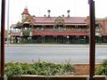 Exchange Hotel. |
 Gold Mine. |
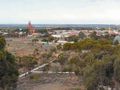 View from the lookout. |
 York Hotel. |
 The Super Pit, Australia's largest open-cut gold mine. |
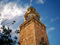 The historical Kalgoorlie Post Office. |
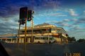 The Kalgoorlie Hotel/Judds Pub. |
See also
- Yilgarn craton
- Auralia (proposed Australian state with its capital in Kalgoorlie)
Notes
- ↑ 1.0 1.1 Australian Bureau of Statistics (25 October 2007). "Kalgoorlie/Boulder (WA) (Statistical District)". 2006 Census QuickStats. http://www.censusdata.abs.gov.au/ABSNavigation/prenav/LocationSearch?collection=Census&period=2006&areacode=5080&producttype=QuickStats&breadcrumb=PL&action=401. Retrieved 2008-04-02.
- ↑ Raymond Radclyffe, Wealth and Wildcats, Carlisle, Western Australia: Hesperian (1898, reprinted 2004), p.15.
- ↑ Railways and roads of Kalgoorlie Singleton, C.C. Australian Railway Historical Society Bulletin, March/April 1954 pp33-36/40-44
- ↑ Diggers and Dealers 2010 - The Song Remains The Same ABC Rural, author: Babs McHugh , published: 2 August 2010, accessed: 26 October 2010
- ↑ Kalgoorlie Consolidated Gold Mines (2007). "The Super Pit - Frequently Asked Questions". Archived from the original on 2008-03-12. http://web.archive.org/web/20080312123226/http://www1.superpit.com.au/pages/faqs.asp. Retrieved 2008-04-02.
- ↑ "Kalgoorlie Miner" Fire Guts Top Floor of Commercial. 4 November 1978. p1.
- ↑ "Kalgoorlie Miner.Oriental Hotel demolition starts amid protests. 29 June 1972. p1.
- ↑ The View On Hannans - formally The Hannans View Motel
- ↑ "Launch of the new Golden Grove project, Kalgoorlie". Department of Housing and Works. 2003-03-05. http://www.dhw.wa.gov.au/news/news_mr_auto.cfm?item=337. Retrieved 2008-02-17.
- ↑ 10.0 10.1 "KEMP, MR DEAN, RETIREMENT" (PDF). Western Australia Hansard. 23 August 2001. p. 2923. http://www.parliament.wa.gov.au/hansard/hans35.nsf/(ATT)/AA8DC99A228D49F448256AB50079FCD8/$file/A36+S1+20010823+p2921c-2923a.pdf. Retrieved 2008-02-17.
- ↑ "Rica Erickson". State Library of Western Australia. 1 September 2001. http://www.slwa.wa.gov.au/erickson/pages/childhood.html. Retrieved 2008-02-17.
- ↑ "Brian Hayes". BBC Press Office. 1 June 2004. http://www.bbc.co.uk/pressoffice/biographies/biogs/radiofivelive/brian_hayes.shtml. Retrieved 2008-02-17.
- ↑ "Lindrum, Walter Albert (1898 - 1960)". Australian Dictionary of Biography:Online. http://www.adb.online.anu.edu.au/biogs/A100674b.htm. Retrieved 2008-02-17.
- ↑ Helen Wolfenden (4 October 2005). "From Kalgoorlie ward to Nobel award". ABC Radio Goldfields Esperance WA. Archived from the original on 2008-03-10. http://web.archive.org/web/20080310194747/http://www.abc.net.au/goldfields/stories/s1476222.htm. Retrieved 2008-02-17.
- ↑ "George Negus Tonight:Tim Rogers". ABC.net.au. http://www.abc.net.au/dimensions/dimensions_people/Transcripts/s845659.htm. Retrieved 2008-02-17.
- ↑ "Olympic Landcare Project". Kalgoorlie-Boulder Urban Landcare Group. http://www.kbulg.org.au/olympic.php. Retrieved 2008-02-17.
- ↑ "WTF is Kev??". Kevin Bloody Wilson official site. Archived from the original on 2007-08-29. http://web.archive.org/web/20070829074056/http://www.kevinbloodywilson.com/site/wtf-is-kev/. Retrieved 2008-02-17.
- ↑ "Kalgoorlie climate statistics". http://www.weatherzone.com.au/climate/station.jsp?lt=site&lc=66124.
- ↑ "Government to help Kalgoorlie quake victims". ABC News (Australian Broadcasting Corporation). 20 April 2010. http://www.abc.net.au/news/stories/2010/04/20/2877497.htm. Retrieved 22 April 2010.
- ↑ O'Connell, Ronan; Pownall, Angela (20 April 2010). "Earthquake strikes Goldfields". Yahoo7 (The West Australian). http://au.news.yahoo.com/thewest/a/-/newshome/7084057/earthquake-strikes-goldfields/. Retrieved 22 April 2010.
References
- Casey, Gavin and Mayman, Ted.(1964) The Mile hanas Midas Touched Rigby, Adelaide..
Further reading
- 100th anniversary of rail link (History of the Eastern Goldfields railway, officially completed on 1 January 1897, to the present, including introduction of the Prospector train on 29 November 1971) Kalgoorlie Miner 1 January 1997, p. 2
- Early Railways in the Kalgoorlie Area Shepley, W.H. Australian Railway Historical Society Bulletin, November, 1965
External links
Kalgoorlie-Boulder travel guide from Wikitravel
- Kalgoorlie official tourism website
- City of Kalgoorlie-Boulder official website
- Kalgoorlie Australia Travel Guide
|
||||||||||||||
|
||||||||||||||||||||||||||
| Preceding station | Transwa Trains network | Following station | ||
|---|---|---|---|---|
|
Bonnie Vale
towards East Perth
|
Prospector | Terminus | ||
| Great Southern Railway | ||||
|
Southern Cross
towards East Perth
|
Indian Pacific |
Rawlinna
towards Sydney
|
||