Kirkcaldy
- "Lang Toun" and "Lang Toon" redirect here. The term is also applied to Auchterarder in Perth and Kinross, and Darvel in East Ayrshire.
| Kirkcaldy | |
| Scottish Gaelic: Cathair Chaladainn[1] | |
| Scots: Kirkcaldy | |
| The Lang Toun[2][3] | |
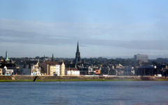 Kirkcaldy from the Firth of Forth |
|
 Kirkcaldy
|
|
| Area | 6.9 sq mi (18 km2) |
|---|---|
| Population | 48,630 [4] |
| - Density | 7,048 /sq mi (2,721 /km2) |
| OS grid reference | |
| - Edinburgh | 11 miles (18 km) S |
| - London | 341 miles (549 km) SSE |
| Council area | Fife |
| Lieutenancy area | Fife |
| Country | Scotland |
| Sovereign state | United Kingdom |
| Post town | KIRKCALDY |
| Postcode district | KY1, KY2 |
| Dialling code | 01592 |
| Police | Fife |
| Fire | Fife |
| Ambulance | Scottish |
| EU Parliament | Scotland |
| UK Parliament | Kirkcaldy and Cowdenbeath |
| Scottish Parliament | Kirkcaldy Mid Scotland and Fife |
| List of places: UK • Scotland • | |
Kirkcaldy (pronounced /kərˈkɔːdi/ (![]() listen); Scottish Gaelic: Cathair Chaladainn) is a town and former royal burgh in Fife, on the east coast of Scotland. It lies on a shallow bay on the northern shore of the Firth of Forth and is the largest settlement between the cities of Dundee and Edinburgh. The name of the town is believed to have derived from the Pictish words Caer and Caled and may translate as "place of the hard fort" or "place of Caled's fort". Kirkcaldy has long been nicknamed the Lang Toun (Scots for 'long town') in reference to the 0.9 mile (1.4 km) main street of the early town, depicted so on maps as early as the 16th and 17th centuries. The street would eventually reach a length of four miles (6.4 km). The estimated population of Kirkcaldy has been recorded as 48,630.
listen); Scottish Gaelic: Cathair Chaladainn) is a town and former royal burgh in Fife, on the east coast of Scotland. It lies on a shallow bay on the northern shore of the Firth of Forth and is the largest settlement between the cities of Dundee and Edinburgh. The name of the town is believed to have derived from the Pictish words Caer and Caled and may translate as "place of the hard fort" or "place of Caled's fort". Kirkcaldy has long been nicknamed the Lang Toun (Scots for 'long town') in reference to the 0.9 mile (1.4 km) main street of the early town, depicted so on maps as early as the 16th and 17th centuries. The street would eventually reach a length of four miles (6.4 km). The estimated population of Kirkcaldy has been recorded as 48,630.
Towards the end of the 11th century, Malcolm III purchased the land around the modern town to gift to the monks of the Holy Trinity (now known as Dunfermline Abbey) to fund for the building of their new church. A linear settlement began to form around a harbour on the East Burn. Early industries which soon prospered in the town included the production of textiles, nailmaking and salt panning. The passing of feu-ferme status in the middle of the 15th century meant the town became semi-independent from the monks of Dunfermline Abbey. Full independence was achieved by a charter for royal burgh status granted by Charles II in 1644.
During the late 19th century, the town became a prosperous centre of linoleum. Originally developed in the town as floorcloth, this was quickly dominated by the Michael Nairn & Co but did not become popular across a worldwide scale until the beginning of the 20th century. Other industries such as coal, flour, malt, printing, light electrical engineering and furniture manufacturing rose in prominence. After the Second World War, a plan saw new housing estates being built to the north-west of the town along with multi-storey flats and the redevelopment of older areas such as Gallatown, Sinclairtown and Pathhead. The population of the town was expected to reach between 55,000 and 70,000, but this was shattered when the production of linoleum declined in the middle of the 1960s.
Today, the town is a centre for the surrounding areas. Kirkcaldy is home to the art gallery, three public parks (Beveridge, Dunnikier and Ravenscraig), shopping facilities and the annual Links Market, Europe's longest street fair. The Adam Smith College also has a presence in the town with three campuses (St Brycedale, Priory and Mitchleson). Employment is now focused in the service sector, with the largest employer being MGT. Other large employers in the town include Victoria Hospital, Forbo-Nairn (floor coverings), Kingdom Bakeries (food and drink)and Kingdom Homes Ltd (residential and Nursing Homes).
Contents |
History
The name Kirkcaldy means "place of the hard fort", or "place of Caled's fort". It is derived from the Pictish caer meaning "fort", caled, which is Pictish "hard" or a personal name, and –in, a suffix meaning "place of". Caled may describe the fort itself or be an epithet for a local "hard" ruler.[5] The earliest mention of the town were made around 1095, when Malcolm III purchased the shire of Kirkaladunt from the crown lords of Fife to be given to the monks of the Holy Trinity Church in Dunfermline (later known as Dunfermline Abbey) as a means of aiding the funding of their newly built church.[6][7][8][9]
Kirkcaldy harbour was acknowledged for having "a sheltered cove round the East Burn", thus giving easy accessibility for boats.[10] The success led to the growth of the burgh, surrounding the harbour, Main Street and Tiel (West) burn.[11] The town eventually became known as the "lang toun" in reference to the 0.9 mile (1.4 km) main street which would later extend to four miles (6.4 km).[2][10]
In 1304 the abbot of Dunfermline requested permission from King Edward I of England (Scotland being under occupation in this period) to hold a weekly market and annual fair (the latter is the basis of the modern Links Market) in this "most ancient of burghs".[7][12][13]
Kirkcaldy was then granted burgh of barony status sometime between 1315 and 1328 by Robert The Bruce.[14] In 1451, the town was awarded feu-ferme status gaining semi-independence from Dunfermline Abbey meaning that it was now free to introduce its own administrative issues and fiscal policies.[7] A charter issued by Charles II granting royal burgh status in 1644, led to full independence of the town. As a gesture, he decided to leave 9 acres (36,000 m2) of common moor to the town suitable "for dying and bleaching of linen, drying of clothes, recreation and perpetuity".[15]
As Kirkcaldy entered into the 19th century, the arrival of the Kirkcaldy and District Railway (later to become part of the North British Railway) helped the town develop into the industrial heart of Fife.[16][17] Due to the increased trade in the harbour, a new wet dock and pier were built from 1843–1846 and this was followed by an inner dock between 1906–1908 for the growth in the linoleum and coal trades.[10][16][18] Kirkcaldy became a centre for iron founding and linen manufacturing—specialising in coarser material (i.e. sailcloth).[19][20] Linoleum was first introduced by the Scottish Linoleum Company (later Barry, Ostlere and Shepherd), due to the expired patent of Frederick Walton in 1877.[21] Although the Michael Nairn & Co Ltd have since become famous, for their trade mark and being the world producers of the cloth.[10][22] The linoleum also made Kirkcaldy recognisable from "the queer-like smell"[11] resulting from the odour of the principal ingredient, linseed oil.[11] Other industries such as coal, pottery, flour, malt, printing, light electrical engineering and furniture manufacturing flourished.[22][23]
The burghs of Pathhead, Linktown, Gallatown and Sinclairtown were amalgamated into the royal burgh of Kirkcaldy in 1876.[3][7][24] The town had a population of nearly 30,000 by the time of the census in 1891. Throughout the 20th century, the town continued to grow with several acquisitions (including most specifically, Dysart) reaching a population of nearly 50,000 by 1951.[7][25][26] New housing estates to the north-west, multi-storey flats and the redevelopment of areas such as Sinclairtown and Linktown occurred between the 1950s and 1960s. There was speculation that the town could grow around the 55,000 to 60,000 mark by 1970. However, the decline of linoleum in the mid-1960s saw the population of the town dip from a peak of 53,750 in 1961 to 47,962 in 1981.[7][26]
Today, Kirkcaldy remains a busy town for the surrounding areas. The town is home to a Museum and Art Gallery; two public parks and shopping facilities in the town centre and Sinclairtown.[6] The town also hosts the annual Links Market commonly known as Europe's longest street fair.[27][28] The production of linoleum still continues to this day, despite being on a vastly reduced scale and now in Swiss ownership.[6] The company which later became 'Forbo-Nairn', diversified into the production of vinyl floor tiles and speciality, marmoleum since 1994.[10][29]
Governance
Kirkcaldy is represented by several tiers of elected government. Both Kirkcaldy North Community Council and Kirkcaldy West Community Council form the lowest tier of governance whose statutory role is to communicate local opinion to local and central government. Fife Council, the unitary local authority for Kirkcaldy, based in Glenrothes is the executive, deliberative and legislative body responsible for local governance.[30] Kirkcaldy has retained some importance as the headquarters of the administrative functions of the town and is the main area office for planning and building control services and library departments in Mid-Fife.[31] The Scottish Parliament is responsible for devolved matters such as education, health and justice while reserved matters are dealt with by the Parliament of the United Kingdom.[30]
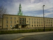
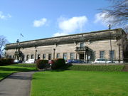
During the middle of the 15th century, the passing of feu-ferme status, for the first time, saw the town being able to deal with their own administrative issues and fiscal policies.[12] The first mention of a town council was made around 1582, where the head courts of the burghs would meet either in the common muir (now known as Volunteers' Green) or the Tolbooth on Tolbooth Street which would be done particularly in the summer months.[12][32] When Kirkcaldy was awarded Royal burgh status in 1644, the duties of the provost were initially completed by bailies, councillors and magistrates (following the passing of an act in 1588 by the burgesses to prohibit the election of provosts).[15] The first Lord Provost as Robert Whyt of the Whyt family was finally elected to the post around 1658. The burgh was also one of four in Scotland to use two coat of arms introduced in 1673, one bearing the motto Vilgilando Munio (I Stand by Watching) and the other displaying the figure of St Bryce, Kirkcaldy's patron saint.[33] Kirkcaldy had its own town council until the royal burgh status was abolished in 1975, under the Local Government (Scotland) Act 1973 and the County Planning (Scotland) Act 1972 in favour of a three-tier authority.[6][34] Between 1975 and 1996, Kirkcaldy was the headquarters of Kirkcaldy District Council (KDC) operating under Fife Regional Council. This was based at Kirkcaldy Town House which was formerly used by the town council.[28]
Kirkcaldy forms part of the county constituency of Kirkcaldy and Cowdenbeath, electing one Member of Parliament (MP) to the House of Commons of the Parliament of the United Kingdom by the first past the post system. Gordon Brown of the Labour Party is the MP for Kirkcaldy and Cowdenbeath.[35] Before the constituency's creation in 2005, Kirkcaldy lay in the Kirkcaldy constituency, represented by Lewis Moonie. For the purposes of the Scottish Parliament, Kirkcaldy forms part of the Kirkcaldy constituency. The Kirkcaldy Scottish Parliament (or Holyrood) constituency created in 1999 is one of nine within the Mid Scotland and Fife electoral region. Each constituency elects one Member of the Scottish Parliament (MSP) by the first past the post system of election, and the region elects seven additional members to produce a form of proportional representation. The constituency is represented by Marilyn Livingstone, MSP also of the Labour Party.[36] Kirkcaldy is represented by seven regional MSPs from the West of Scotland electoral region.[37]
Geography
Kirkcaldy is located on a bay facing southeast onto the Firth of Forth, along a sandy cove.[6][38] The town is located in the Midland Valley of Scotland between the major cities of Edinburgh and Dundee 30 miles (48 km) away.[39] The town is triangular in shape with relatively low-lying ground being a feature to the south-west near Invertiel and to the east of Boreland both areas of the town. Agricultural land in the vicinity of Kirkcaldy supports cereals, grass, potatoes, field beans, other vegetables and roots. The soil derives from Carboniferous limestone and Old Red Sandstone gravels and raised beach sands.[38] The town's national grid reference is NT275915.[40]
 |
Cardenden | Glenrothes | Buckhaven | |
| Dunfermline | Firth of Forth | |||
| Burntisland | Kinghorn | Firth of Forth |
Areas in and around the town centre at 50 feet (15 m) above sea level contain clay, sand and gravel while the majority of Pathhead, Ravenscraig Park and older parts of Dysart at 100 feet (30 m) contained sandy gravel and shaley soil. The highest piece of ground in the vicinity of the town, west of the Raith Estate at 500 feet (150 m), contains hard volcanic ash while to the north of the estate (Sauchenbush and south-east Chapel) are dolerite rock outcrops. An area to the south-west of the town, south of the Raith Estate and Invertiel, is practically impossible to build houses upon because of the thin drift and a propensity of basalt fragments.[41] A 25-foot (7.6 m) raised beach to the west of the High Street (a result of sea level changes 5–10,000 years ago) is likely to have heavily influenced Kirkcaldy's mediaeval form and development.[38]
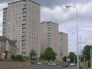
Kirkcaldy developed as a linear settlement stretching along the sandy cove between the Tiel Burn in the south and the East Burn to the north. More recently as the town has developed north the settlement shape is more triangular in form.[6][38][42] The first development plan in the town, after the Second World War was to focus towards new private sector housing to the north and west. Much of this land was suitable since there were no man-made or natural barriers in the way. Older areas in the town such as Gallatown, Sinclairtown, Pathhead and Linktown would also be subsequently redeveloped under the plan.[26][43] A good mix of both private and public housing was guaranteed and having more smaller scale residential developments including land that applies to availability returns.[44] The construction of the first multi-storey flats in the town began with Viewforth (built in 1958) to the south-west of the town and Ravenscraig (built between 1963–1964) to the east of the town.[45]
A local plan replaced the first development plan in the early 1980s, under the Town and Country Planning (Act) Scotland 1972 and Local Government (Scotland) Act 1973. This new plan dealt with highlighting areas for local authorities, private organisations and individuals while looking at the availability and best use of greenfield sites around the town, although brownfield land within Kirkcaldy was also considered.[46] New housing developments focused towards the south-west and north-west of the town.[47] The 1980s Local Plan also promoted the upgrading of many roads within and surrounding the town including the completion of the Thornton by-pass (Glenrothes–Kirkcaldy Road) in 1980 and East Fife Regional Road (A92) in 1990 – which the latter saw the town finally connect to the motorway system bringing viable growth and new development.[48][49]
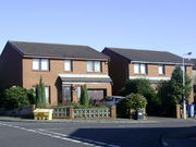
Another local plan developed in the early 1990s aimed to regenerate Kirkcaldy by creating new employment opportunities in the north of the town and facilitating the creation of a variety of housing types and conditions. A major objective was to improve the state of residential areas by promoting suitable development land within the town.[49] The majority of new housing was development by private developers in the south-east (Seafield) and north-west (Chapel Farm site) of the town. The new local plan also allowed out-of-town shopping facilities to be developed, conveniently located adjacent to the new A92 junction at Chapel.[50]
Demography
| Kirkcaldy | Fife | Scotland | |
|---|---|---|---|
| Total population | 46,912 | 349,429 | 5,062,011 |
| Foreign born | 1.01% | 1.18% | 1.10% |
| Over 75 years old | 8.57% | 7.46% | 7.09% |
| Unemployed | 5.68% | 3.97% | 4.0% |
According to the 2001 census, Kirkcaldy had had a total population of 46,912.[51] A more recent population estimate of Kirkcaldy has been recorded at 48,630 in 2009.[4] The demographic make-up of the population is much in line with the rest of Scotland. The age group from 30 to 44 forms the largest portion of the population (22%).[51] The median age of males and females living in Kirkcaldy was 37 and 41 years respectively, compared to 37 and 39 years for those in the whole of Scotland.[51]
The place of birth of the town's residents was 96.52% United Kingdom (including 87.15% from Scotland), 0.28% Republic of Ireland, 1.18% from other European Union countries, and 1.86% from elsewhere in the world. The economic activity of residents aged 16–74 was 40.13% in full-time employment, 12.17% in part-time employment, 4.79% self-employed, 5.68% unemployed, 2.57% students with jobs, 3.06% students without jobs, 15.70% retired, 5.51% looking after home or family, 6.68% permanently sick or disabled, and 3.71% economically inactive for other reasons. The number of children living in low income families is 46% within the constituency of Kirkcaldy and Cowdenbeath. Compared with the average demography of Scotland, Kirkcaldy has low proportions of people born outside the United Kingdom but has higher proportions for people over 75 years old.
A local plan which looks forward to 2026 says that the Mid-Fife area will need at least 6,730 more houses to keep the population stable. There is expected though to be a 0% growth in population issued by the Housing Market Area (HMA). The urgent need for more housing alongside the SEA (Strategic Environmental Assessment) was the result of the Environment Assessment of Plans and Programmes (Scotland) regulations in 2004.[55] The main areas of growth will be seen to the east and south-west of the town coinciding with the 20-year plan by SLA (Scottish Land Allocations).[56]
Economy
Today, the town is Fife's third largest employment centre with approximately 21,500 people employed.[39] The majority of jobs now being provided by service sector.[39] The largest employer in the town is the MGT call centre. Other employers include: Forbo Nairn (floorcloth coverings), Adam Smith College, ESA McIntosh (school furniture manufacturers), Victoria Hospital and Kingdom Bakeries (food and drink).[39]
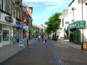
Kirkcaldy has the largest shopping area in Fife and currently the largest provision of all of the council area town centres.[39][57] The town centre which is focused along the High Street, running parallel with the coast, is home to a number of major retailers with both The Mercat Shopping Centre and The Postings Shopping Centre in the vicinity.[58] A BID (Business Improvement District) scheme has been introduced within the town centre area, following a vote in favour by eligible businesses.[59] Kirkcaldy received £2,000,000 from the Scottish Government's £60,000,000 Town Centre Regeneration Fund to revamp the town centre.[60] Work is to begin in May 2010 and will include the replacement of surface materials, street furniture, better lighting and new signage. Preparations are to be made for a new public Wi-Fi network.[61]
Culture
Considered by many to be one of Scotland's finest museums, the Kirkcaldy Museum and Art Gallery was donated in 1925 (by Nairn's benefactor, John Nairn the grandson of Michael Nairn), contains a notable collection of paintings by the Scottish Colourists and a permanent display of the town's industrial heritage.[62][63] The nearby Adam Smith Theatre on Bennochy Road which opened in 1899 by Andrew Carnegie, was also gifted to the town by linen manufacturer and town provost, Michael Beveridge to preserve the legacy of Adam Smith on the 100th anniversary of his death.[64][65][66] The theatre is the home of the annual Fife Festival of Music and Fife Opera, as well as Kirkcaldy Amateur Dramatic Society, Kirkcaldy Amateur Operatic Society, and the Kirkcaldy Gilbert and Sullivan Society.[67][68]
The famous Links Market sited on the Promenade every year, widely claimed to be "Europe's longest street fair" began as a farmers' market in 1304 before moving to Sands Road (later to be known as the Promenade) in 1903.[69] The 700th anniversary of the market was celebrated in 2004.[69] Another tradition of the town is the Kirkcaldy pageant, which began in 1923 to raise money for several hospitals in the area (later local charities) with the help and support of local firms.[45] The town is mentioned in a reference to the fictional "Duchess of Kirkcaldy" in the song Cry Baby Cry by The Beatles on the White Album. The band's visit to the town on a Scottish tour in late 1963 may have inspired John Lennon.[70]
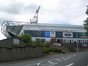
Kirkcaldy is home to professional league teams in football, rugby and ice hockey.[71] The senior football club, Raith Rovers play in the Scottish Football League First Division at their home ground of Stark's Park.[72] The town's only junior team, Kirkcaldy YM play their games at Denfield Park on Den Road.[73] The senior rugby side, Kirkcaldy RFC are based at the Beveridge Park and will play in the BT Premiership 2 Division from the 2009–2010 season. Fife Flyers are acknowledged in United Kingdom for being the oldest surviving Ice Hockey team. They play their games in the Fife Ice Arena. A tradition which has kept since the end of the Second World War has been the recruitment of Canadian players.[71] Other clubs of note include a cricket club at Dunnikier Park; a private lawn and tennis club on Boglily Road and a curling club who also play at the Fife Ice Arena.[71] There are also plans to build a new multi-million pound sports centre in the town centre replacing the existing swimming pool.[74]
People
Locally, the town is also known for having six famous sons who are: "the father of modern economics" Adam Smith (1723–90); "Demarcator of Standard Time" Sandford Fleming (1827–1915); one of Scotland's most famous architects, Robert Adam (1728–92); linen manufacturer and philanthropist, Baillie Robert Philp (1751–1828); missionary to South Africa, Dr John Philip (or Philp) (1775–1851) and first European explorer of Australia, John McDouall Stuart (1815–66). These names have all been acknowledged in Kirkcaldy's Town House, all for the exception of Robert Philip.[75][76] Although, in the last decade, two further names have been added: poet, diarist and author, Marjorie "Pet Majorie" Fleming (1803–11) and floorcloth later linoleum manufacturer, Michael Nairn (1804–58).[77]
Other notable people associated with or hailing from the town include the former Prime Minister of the United Kingdom, Gordon Brown; the author John Buchan; architect William Adam; artist Jack Vettriano; writers Ian Rankin and Val McDermid and professors Duncan Glen, William Walker, Henry Moyes and Tom Hubbard. In politics, the town boasts Governor-General of Australia, Ronald Munro-Ferguson; David Steel the final leader of the Liberal Party and the first female judge of the Supreme Court of Canada and Court of Appeal for Ontario, Bertha Wilson. In popular culture, the town also boasts the Coldplay bassist, Guy Berryman. In sport, the two-time world darts champion, Jocky Wilson comes from the town. William Arnott (1827-1901), biscuit manufacturer in Australia, was born on 6 December 1827 in Pathhead.[78][79]
Landmarks
_Old_Kirk,_Kirkcaldy.jpg)
The town centre of Kirkcaldy is a conservation area which was awarded in 1980.[80] The oldest church in Kirkcaldy is the Old Parish Church (otherwise known as the Old Kirk) on Kirk Wynd.[81] The earliest record of the Old Kirk was the consecration in 1244 to St Brisse and St Patrick by Bishop de Bernham of St Andrews.[82] The present Old Kirk was re-built between 1807 and 1808 in a Georgian style, when the former church fell into disrepair.[10] Only the square western tower of the former church was retained. This medieval tower, which dates from around 1500, has played both religious and defensive roles in its history.[10][83] On the north side of the town centre is Kirkcaldy Town House, the fourth to be built in the town, designed in 1937 by David Carr and William Howard of Edinburgh and completed between 1953 and 1956.[84][85] At the corner of Hunter Street and Wemyssfield, is the baronial Kirkcaldy post office built between 1900 and 1902 in a Scottish baronial style and was one of the first buildings in Scotland to have the initials and coat of arms of King Edward VII, then monarch of United Kingdom.[86][87]
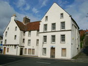
To the north-east of the town are two important buildings associated with or at one stage the homes of wealthy merchants and shipowners connected with Kirkcaldy's harbour.[88][89] The Merchant's House located at 339–343 High Street, built by the Law family around 1590, is considered to be one of Scotland's finest 16th century town houses and it has been stated by Scottish Heritage Trust that this may "be the most important town house outside the cities".[89][90] The decor and quality of the building has been claimed to be similar to that of Culross Palace in Culross and Gladstone's Land in Edinburgh.[90] The A-listed Sailors' Walk located at 443–449 High Street, were initially a pair of two Flemish style 17th century dwellings.[91] In 1650, Charles II stayed at the house as a lodger, when on a tour of Scotland, after being crowned King at Scone Palace.[11] Mary, Queen of Scots, has been rumoured to be have been a regular visitor to the house, on her frequent journeys to Falkland Palace.[91] The house was nearly demolished in 1934, but was saved by a forward-looking committee and was acquired in 1935 by the National Trust for Scotland.[91] Later, Wheeler and Sporson undertook reconstruction work on the building between 1954 and 1959.[91]
_Dunnikier_House,_Kirkcaldy.jpg)
North of the harbour area on the Path are two excellent examples of distinctive architectural styles.[90] The impressive B-listed Hutchison's House was designed by George Spears, the owner of the nearby East Bridge distillery, in 1793. Displaying an ellipticed fanlight and doric-columned Venetian windows, these are evidence of his wealth.[90][92] At the top of the Path, is the A-listed Path House (initially known as Dunnikier House) a three-storey L-plan tower house designed by John Watson of Burntisland in 1692.[90][92][93] The house became a residence for the Oswald family – specifically Captain James Oswald – when Watson sold the property in 1705 citing financial difficulties.[94] In 1979, the house was given an amenity award by the Kirkcaldy Civic Society. Today, the house is used as a doctor's surgery.[93]
To the north of the town is the late 18th century B-listed Dunnikier House, one of Kirkcaldy's two "big houses". The house was designed by Alexander Laing of Edinburgh and built by Sir John Oswald as a family residence until this was sold to Kirkcaldy Town Council in 1944. Dunnikier has since been converted into a three-star hotel.[90][94][95] The other "big house" is the late 17th century A-listed Raith House, to the south-west of the town. The house was designed by James Smith, one of only two country houses he completed in Fife and was built by Sir Alexander Raith, 4th Earl of Raith and Melville for his bride, Barbara Dundas.[94][96][97] Today, Raith is owned by the Ferguson family as a private residence.[94][97]
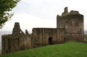
A dominant feature to the east of the town are the ruins of Ravenscraig Castle on a rocky spit of land extending into the Firth of Forth.[98][99] The castle is best known as one, if not the first, in Scotland as an attempt for artillery defence to withhold cannon fire from the wall thickness; frequent shot-holes and an apparent rock-cut ditch.[92][100][101] James II began construction of the castle in 1460 to defend the important port of Dysart along with the small harbour of Kirkcaldy to protect the crown lords of Fife against piracy and English rivalry.[92] When the King died in an accident involving a cannon at the siege of Roxburgh Castle, work continued on the castle until 1463 and was resumed when it was sold to William Sinclair (known as Earl of Sinclair) in 1470. Ravenscraig was finally taken into state care in 1955.[11] The castle has been listed as a Category A structure by Historic Scotland and is now owned by the Parks Departments of Fife Council.[102][103]
The Adam Smith House is the building where Adam Smith wrote The Wealth of Nations.
The town has an impressive war memorial, set within gardens. It is one of the largest in the area. It was designed by sculptor George Henry Paulin.[104]
Education
The first grammar school established in the town was known as Kirkcaldy Burgh School in 1582, which was set up with the help of the local minister, Dr David Spens. Until premises were found, pupils of the school were taught in the minister's house.[105] Notable pupils of the school included both Robert Adam and Adam Smith.[106] The school found premises on Hill Street before being replaced by Kirkcaldy Grammar School on St Brycedale Avenue in 1843.[106][107] A Government list described the school as being of "higher class" in 1872.[107] Other schools were established such as girls schools, subscription schools, apprentice schools and Philp Schools (from 1830).[106] The passing of the Education (Scotland) Act in 1872 replaced voluntary education in the town with a school-based education for all children between the ages of 5 to 13.[108]
Today, Kirkcaldy has four secondary schools and twelve primary schools.[109][110] Other educational facilities include a private school and a school for children with learning difficulties.[111] The oldest secondary school is Kirkcaldy High School (formerly the Burgh School) which has occupied a site on the north side of the town since 1958.[45] Balwearie High School, one of the best performing schools in Scotland, serves the western end of the town, including Kinghorn and Burntisland.[112][113][114] The school opened as a junior secondary in 1964, only to be upgraded as a high school in 1972.[111][114] Viewforth High School, another former junior secondary, serves pupils living in the east side of the town and neighbouring Dysart.[115] A new secondary school to serve the east side of Kirkcaldy was scheduled to replace Viewforth, but this has been delayed with the starting date not due to begin until 2017.[116] St Andrews RC High School, one of only two Roman Catholic secondary schools in Fife, caters for pupils living in the eastern half of Fife from Cupar to Burntisland.[117]
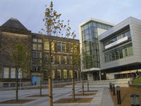
Scotland's third largest college, the Adam Smith College has three campuses in the town. St Brycedale Campus on St Brycedale Avenue in Kirkcaldy Town Centre serves as the main college campus.[118] A second campus known as Priory Campus is on Victoria Road to the east of the town. A third campus is located within Mitchleson Industrial Estate to the north of the town under the name of Fife Institute of Technology.[118] The college was formed in 2005 from a merger between Glenrothes College and the Fife College of Further and Higher Education.[119][120]
Public services
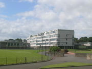
_Victoria_Hospital,_Kirkcaldy.jpg)
Waste management is handled by Fife Council. There is a kerbside recycling scheme in operation in the town. Cans, glass and plastic bottles are collected on a weekly basis.Compostable material and non-recyclable material are collected on alternate weeks. Paper is collected for recycling on a four-weekly basis.[121]
Kirkcaldy has one recycling centre and several recycling points, all operated by Fife Council.[122] Items which are accepted include steel and aluminium cans, cardboard, paper, electrical equipment, engine oil, fridges and freezers, garden waste, gas bottles, glass, liquid food and drinks cartons, plastic bottles, plastic carrier bags, rubble, scrap metal, shoes and handbags, spectacles, textiles, tin foil, wood and yellow pages.[122] Overall, Fife Council has a recycling rate of 41%..
Healthcare is supplied by NHS Fife who also have their headquarters in the town at Hayfield House. The Victoria Hospital is the only accident and emergency hospital serving Kirkcaldy and Mid-Fife.[123] A new block to the south of the main entrance, currently the largest building project in the east of Scotland, is to be completed in 2012.[124][125] This will provide a maternity unit; eleven operating theatres; 500 new beds and a relocated Accident and Emergency Department.[125] Whytesmans Brae Hospital, which is part of the complex, serves psychiatry and elderly patients.[126] The Scottish Ambulance Service have an ambulance station at Whyteman's Brae and another one, near the Victoria Hospital.[127] Primary Health Care in Kirkcaldy is supplied by a number of General Practices. Governmental facilities also include Kirkcaldy Police Station, Kirkcaldy Fire Station and Kirkcaldy Sheriff Court.[128][129]
Transport

Kirkcaldy is served by the A910 road which connects the A92 with Dunfermline to the west and Glenrothes and Dundee to the north. The main route through the town, Chapel Level and Dunnikier Way (B981) runs from Chapel Junction in the west to Redhouse Roundabout in the east where this meets the A92 and joins up with the A915, A955 and A921.[130][131] The A915 known locally as the Standing Stane Road connects the town to St Andrews and Leven to the north-east and the A921 to Kinghorn, Burntisland and Aberdour via St Clair Street and The Esplanade to the south-west. The A955 also connects the town to Dysart and East Wemyss to the south-east.[132][133]
The main bus station is located on a site to the north of the town centre providing seating, toilets, a cafe and a hairdresser.[39] A railway station can also be found to the north-west of the town centre which is on the route for Fife Circle Line and National Express East Coast.[134] The station has half-hour services to both Dundee and Edinburgh Waverley.[39] Other services run from locations such as Perth, Aberdeen and Inverness to the north and Newcastle Central, York, London King's Cross south of the border.[135] Nearby stations such as Burntisland and Kinghorn exist to the west of the town. The nearest major international airport is Edinburgh Airport 26 miles (42 km) and nearest ferry sea port at Rosyth 17 miles (27 km) from the town.
References
Notes
- ↑ Iain Mac an Tàilleir (2003). "Scottish Gaelic Placenames" (PDF). Scottish Parliament. p. 75. http://www.scottish.parliament.uk/vli/language/gaelic/pdfs/placenamesK-O.pdf. Retrieved 2008-08-10.
- ↑ 2.0 2.1 Pearson Around Kirkcaldy pp12–15
- ↑ 3.0 3.1 Civic Society History & Celebration pp10–11
- ↑ 4.0 4.1 "Mid-2008 Population Estimates – Settlements in Alphabetical Order". General Register Office for Scotland. 2010. p. 7. http://www.gro-scotland.gov.uk/files2/stats/population-estimates/08mye-settlements-table1.pdf. Retrieved 2010-09-04.
- ↑ Taylor and Márkus The Place-Names of Fife: Volume One p.487.
- ↑ 6.0 6.1 6.2 6.3 6.4 6.5 Civic Society Kirkcaldy Remembered pp.6–8.
- ↑ 7.0 7.1 7.2 7.3 7.4 7.5 Eunson Old Kirkcaldy: Central, North and West pp3–4
- ↑ Omand 2000, p.105.
- ↑ MacBean 1908, p.33.
- ↑ 10.0 10.1 10.2 10.3 10.4 10.5 10.6 Pride Kingdom of Fife pp51–52
- ↑ 11.0 11.1 11.2 11.3 11.4 Lamont-Brown Fife in History and Legend pp145–146
- ↑ 12.0 12.1 12.2 Torrie & Coleman Historic Kirkcaldy p.12.
- ↑ Brown The Fife Journal p.82.
- ↑ Omand The Fife Book p.136.
- ↑ 15.0 15.1 Civic Society Kirkcaldy: A History and Celebration pp17–18
- ↑ 16.0 16.1 Omand The Fife Book p.195.
- ↑ Awdry Encyclopaedia of British Railway Companies p.141.
- ↑ Eunson Old Kirkcaldy: Central, North and West 1998, p.6.
- ↑ Civic Society Kirkcaldy Remembered, p.89.
- ↑ Omand 2000, p.189.
- ↑ McKay 2002, p.64.
- ↑ 22.0 22.1 Civic Society Kirkcaldy: A History and Celebration, p.80.
- ↑ Civic Society Kirkcaldy: A History and Celebration, p.30.
- ↑ MacBean 1908, p.60.
- ↑ Civic Society Kirkcaldy: A History and Celebration, p.54.
- ↑ 26.0 26.1 26.2 Royal Burgh of Kirkcaldy County Council Kirkcaldy Development Plan of 1952
- ↑ Brown Fife Coast p.62.
- ↑ 28.0 28.1 Pearson Around Kirkcaldy, p.17.
- ↑ Omand, Donald The Fife Book, 2000
- ↑ 30.0 30.1 "Reserved and devolved matters". Scotland Office. http://www.scotlandoffice.gov.uk/what-we-do/reserved-and-devolved-matters.html. Retrieved 2009-06-14.
- ↑ "Kirkcaldy Town House, headquarters of administrative department". Fife Council. 2009-15-06. http://www.fife.gov.uk/atoz/index.cfm?fuseaction=facility.display&facid=DB505357-065F-0899-0CC4D6EA85ABC89A.
- ↑ Torrie & Coleman Historic Kirkcaldy p.30.
- ↑ Fife Council Kirkcaldy's History Its Places and Its Famous Folk p.10.
- ↑ Planning Handbook (1st edition ed.). Kirkcaldy District Council. 1979.
- ↑ "Gordon Brown MP profile". BBC News. 2010. http://news.bbc.co.uk/democracylive/hi/representatives/profiles/25779.stm. Retrieved 2010-05-13.
- ↑ "Kirkcaldy and Mid-Fife MSP info". Scottish Parliament. http://www.scottish.parliament.uk/msps/locate/con-kirk.htm. Retrieved 2008-08-17.
- ↑ "Regional MSPs". scottish.parliament.uk. http://www.scottish.parliament.uk/msps/locate/con-east.htm. Retrieved 2009-12-31.
- ↑ 38.0 38.1 38.2 38.3 Torrie and Coleman Historic Kirkcaldy pp5–6
- ↑ 39.0 39.1 39.2 39.3 39.4 39.5 39.6 "Kirkcaldy Economic Profile" (PDF). Fife Council. June 2006. http://www.fifedirect.org.uk/uploadfiles/publications/c64_RevisedKirkcaldy_Apr07.pdf. Retrieved 2008-06-23.
- ↑ "Ordnance Survey of Kirkcaldy's location". http://getamap.ordnancesurvey.co.uk/getamap/frames.htm?mapAction=gaz&gazName=p&gazString=KIRKCALDY. Retrieved 2008-07-21.
- ↑ Kirkcaldy District Council (Feb 1980) Kirkcaldy Local Plan - Planning Issues, p.3.
- ↑ Kirkcaldy District Council Kirkcaldy Local Plan 1986
- ↑ Sinclairtown redevelopment scheme, The Fife Free Press, May 16, 1964
- ↑ Kirkcaldy District Council Kirkcaldy Local Plan: Report Survey 1980
- ↑ 45.0 45.1 45.2 Civic Society Kirkcaldy: A History and Celebration pp35–36
- ↑ Kirkcaldy District Council Kirkcaldy Local Plan 1982, 1982, p.5.
- ↑ Kirkcaldy District Council Kirkcaldy Local Plan 1986 Monitor, 1986, pp12–13
- ↑ Kirkcaldy District Council (April 1981) Kirkcaldy draft local plan, p.9.
- ↑ 49.0 49.1 Kirkcaldy District Council Kirkcaldy Local Plan 1991, p.5.
- ↑ Kirkcaldy District Council Kirkcaldy Local Plan 1991, p.7.
- ↑ 51.0 51.1 51.2 51.3 "Comparative Populartion: Kirkcaldy Locality Scotland". scrol.co.uk. 2001. http://www.scrol.gov.uk/scrol/browser/profile.jsp?profile=Population&mainArea=Kirkcaldy&mainLevel=Locality. Retrieved 2008-10-30.
- ↑ "Comparative Population Profile: Fife Council Area Scotland". scrol.gov.uk. 2001. http://www.scrol.gov.uk/scrol/browser/profile.jsp?profile=Population&mainLevel=CouncilArea&mainArea=Fife&mainText=&mainTextExplicitMatch=false&compLevel=CountryProfile&compText=&compTextExplicitMatch=null. Retrieved 2008-05-29.
- ↑ "Comparative Employment Profile: Kirkcaldy Locality Scotland". scrol.gov.uk. 2001. http://www.scrol.gov.uk/scrol/browser/profile.jsp?profile=Employment&mainLevel=Locality&mainText=Kirkcaldy&mainTextExplicitMatch=false&compLevel=CountryProfile&compText=&compTextExplicitMatch=null. Retrieved 2008-09-30.
- ↑ "Comparative Employment Profile: Fife Locality Scotland". scrol.gov.uk. 2001. http://www.scrol.gov.uk/scrol/browser/profile.jsp?profile=Employment&mainLevel=CouncilArea&mainArea=Fife&mainText=&mainTextExplicitMatch=false&compLevel=CountryProfile&compText=&compTextExplicitMatch=null. Retrieved 2008-09-30.
- ↑ Fife Council (Feb 2002) Kirkcaldy Local Plan - Pre-Inquiry Modifications, p.11.
- ↑ Fife Council (Feb 2002) Kirkcaldy Local Plan - Pre-Inquiry Modifications, p.16.
- ↑ "Town Centre Footfall Report" (DOC). Fife Council. October 2006. http://www.fife.gov.uk/uploadfiles/publications/c64_TownCentreFootfallFinalReportOct2006.doc. Retrieved 2008-06-23.
- ↑ "Kirkcaldy Town Centre Fact Sheet" (PDF). Fife Council. October 2006. http://www.fife.gov.uk/uploadfiles/publications/c64_KirkcaldyTownCentreFS.pdf. Retrieved 2008-06-25.
- ↑ "Kirkcaldy BID". Fife Council. http://www.fifedirect.org.uk/news/index.cfm?fuseaction=news.display&objectid=2F4993F5-95AA-6A6C-85757AE1A9D2B7F0. Retrieved 2010-04-12.
- ↑ "Town Centre Regeneration Fund first tranche". Scottish Government. September 2009. http://www.scotland.gov.uk/Topics/Built-Environment/regeneration/town-centres/tcrf/FirstTrancheAllocations. Retrieved 2010-04-13.
- ↑ Civic Society Kirkcaldy Remembered, p.72.
- ↑ Civic Society Kirkcaldy: A History and Celebration, p.33.
- ↑ Civic Society Kirkcaldy Remembered p.11.
- ↑ Civic Society, Kirkcaldy's Famous Folk 3, 2000, p.59.
- ↑ Civic Society, Town Centre Walkabout, 2000, p.13.
- ↑ Civic Society Kirkcaldy Remembered, p.49.
- ↑ "Fife Festival of Music". Fife Council. http://www.fifedirect.org.uk/events/index.cfm?fuseaction=event.display&objectid=95D9B9D1-D6E8-18BF-25DE7D8F8E287717. Retrieved 2008-10-24.
- ↑ 69.0 69.1 Civic Society Kirkcaldy: A History and Celebration, p.114.
- ↑ Beatles in Scotland p.153.
- ↑ 71.0 71.1 71.2 Civic Society Kirkcaldy: A History and Celebration, pp.50–52
- ↑ "Raith Rovers F.C. team info". Scottish Football League. http://www.scottishfootballleague.com/scottish_football.cfm?curpageid=1180. Retrieved 2010-05-13.
- ↑ "list of Scottish Junior football teams A-K". Scottish Football Junior Football Association. http://www.footballcentral.org/sfa/associations/scottish-junior-football-association/club-directory-a-k.cfm. Retrieved 2009-03-08.
- ↑ "Kirkcaldy Leisure Centre". Cre8 Architecture. 2009-12-01. http://www.cre8architecture.com/projects/leisure-arts/kirkcaldy-leisure-centre/. Retrieved 2009-12-28.
- ↑ Civic Society Kirkcaldy's Famous Folk 1 2000 pp.1, 3, 9, 11, 25, 39, 46, 55.
- ↑ Fife CouncilKirkcaldy's History, Its Places and Its Famous Folk Sept. 2000, pp.19, 22, 25, 27, 29.
- ↑ Fife Council, "Kirkcaldy's History, Its Places and Its Famous Folk", Sept. 2000, p.16.
- ↑ Arnott's Biscuits — One Hundred Years (Syd, 1968); Maitland Mercury, 1851-65, 1883, especially 27 Aug 1857, 1, 8 Sept 1883; Newcastle Morning Herald, 1 Sept 1877, 18 Sept 1880, 24 Sept 1889, 12 Apr 1893, 16 Oct 1897, 15 Sept 1899, 23, 24, 25, 26 July 1901; family papers (privately held).
- ↑ "The History of Arnott's". Arnott's. http://www.arnotts.com/history.aspx.
- ↑ "Conversation Area granted". "The Fife Free Press". 1980-06-13. p. 1.
- ↑ Pearson 1993, p.16.
- ↑ Civic Society Kirkcaldy: A History and Celebration 2005 p.17.
- ↑ Omand The Fife Book p.134.
- ↑ Civic Society Town Centre Walkabout p39"
- ↑ Fife Council Kirkcaldy's History: Its Places, Its People p1
- ↑ Civic Society Town Centre Walkabout p41
- ↑ Gifford The Buildings of Scotland: Fife p.283.
- ↑ Torrie and Coleman, Historic Kirkcaldy p.61.
- ↑ 89.0 89.1 Glen, Duncan Kirkcaldy: A New Illustrated History p.24.
- ↑ 90.0 90.1 90.2 90.3 90.4 90.5 Pride, Glen L. Kingdom of Fife pp55–58
- ↑ 91.0 91.1 91.2 91.3 McNeill, Carol Kirkcaldy: In Old Picture Postcards p.21.
- ↑ 92.0 92.1 92.2 92.3 Torrie and Coleman Historic Kirkcaldy pp63–64
- ↑ 93.0 93.1 Civic Society Pathhead and Ravenscraig Castle p.25.
- ↑ 94.0 94.1 94.2 94.3 Civic Society Kirkcaldy: A History & Celebration pp13–14
- ↑ Civic Society Kirkcaldy's Famous Folk: Volume 3 p.1.
- ↑ Pride, Glen L. Kingdom of Fife p.103.
- ↑ 97.0 97.1 Civic Society, Kirkcaldy Town Centre Walkabout p.46.
- ↑ Pride Kingdom of Fife 1999, p.60.
- ↑ Omand, Donald The Fife Book p.149.
- ↑ Eunson Old Dysart and East Kirkcaldy 1998, p.27.
- ↑ Walker and Ritchie Fife, Perthshire and Angus p.117.
- ↑ Lamont Brown Fife in History and Legend 2002, p.149.
- ↑ "Ravenscraig Park, Ravenscraig Castle, Listed Building Report". Historic Scotland. http://hsewsf.sedsh.gov.uk/hslive/portal.hsstart?P_HBNUM=36404. Retrieved 2009-01-21.
- ↑ A brief Biography of George Henry Paulin, Air Comm. Marcus Wetherspoon
- ↑ Civic Society Kirkcaldy Remembered, p.41.
- ↑ 106.0 106.1 106.2 Civic Society Kirkcaldy: A History and Celebration 2002, p.21.
- ↑ 107.0 107.1 Civic Society Kirkcaldy Remembered, p.44.
- ↑ Civic Society Kirkcaldy: A History and Celebration, p.22.
- ↑ "A list of all primary schools in Fife". Fife Council. http://www.fifedirect.org.uk/topics/index.cfm?startRow=51&OBJECTID=xxx&ORDERBY=location&FUSEACTION=Facility%2EList&SUBJECTID=0AB411F8%2D508B%2DDE79%2D478BA07C673E89C9. Retrieved 2009-12-20.
- ↑ "A list of all secondary schools in Fife". Fife Council. http://www.fifedirect.org.uk/topics/index.cfm?fuseaction=Facility.List&subjectid=EC1C63EC-508B-DE79-470C9585EF1932A4&objectid=xxx&orderby=location. Retrieved 2009-12-20.
- ↑ 111.0 111.1 Glen Kirkcaldy: An Illustrated History p.116.
- ↑ "Balwearie High School profile". Fife Council. http://www.fife.gov.uk/atoz/index.cfm?fuseaction=facility.display&facid=9678A744-536F-4D41-B4B85BD7453BEC6A. Retrieved 2008-06-23.
- ↑ Shannon, Kate (2008-06-11). "Balwearie at the top of the class". Fife Free Press. http://www.fifetoday.co.uk/news/Balwearie-at-the-top-of.4175669.jp. Retrieved 2008-06-23.
- ↑ 114.0 114.1 "Balwearie High School Kirkcaldy Inspection 10/06/2008". HMIE. http://www.hmie.gov.uk/documents/inspection/5406838BalwearieHS.html. Retrieved 2009-02-01.
- ↑ Eunson Old Dysart and East Kirkcaldy 1998, p.43.
- ↑ "Unease at school building priorities". The Fife Free Press. 2009-01-21. http://www.fifetoday.co.uk/fife-free-press-news/Unease-at-school-building-priorities.4876256.jp.
- ↑ "St Andrews RC High School status". Fife Council. http://www.fife.gov.uk/atoz/index.cfm?fuseaction=facility.display&facid=97B6298C-418C-4F11-BCBE5F5909037A69. Retrieved 2008-07-08.
- ↑ 118.0 118.1 "Adam Smith College campus info". Adam Smith College. http://www.adamsmithcollege.ac.uk/general/contactinfo/default.aspx. Retrieved 2007-06-28.
- ↑ "Adam Smith College inspection". Her Majesty's Inspector of Schools in Scotland (HMIE). 2007-07-09. http://www.hmie.gov.uk/documents/inspection/Adam%20Smith%20Main.html. Retrieved 2009-01-01.
- ↑ "Fife College no more,". Fife Free Press. 2005-07-27. http://www.fifetoday.co.uk/news/New-name-and-a-new.1098682.jp. Retrieved 2008-06-25.
- ↑ "kerbside recycling in Fife". Fife Council. http://www.fifedirect.org.uk/atoz/index.cfm?fuseaction=faq.display&faqid=83334E8D-BF78-4BE8-2A55B210931AE05D. Retrieved 2009-07-01.
- ↑ 122.0 122.1 "Recycling centre in Kirkcaldy". sort-it.org.uk. http://www.sort-it.org.uk/capRes.asp?material=23&town=Kirkcaldy&AuthID=14&CatID=24&Submit=+Search+. Retrieved 2009-07-01.
- ↑ "Victoria Hospital, Kirkcaldy". NHS Fife. http://www.nhsfife.scot.nhs.uk/publications/maps/victoria.pdf. Retrieved 2009-07-01.
- ↑ "Kirkcaldy's Victoria Hospital Wing Taking Shape". The Courier. 2010-07-28. http://www.thecourier.co.uk/News/Fife/article/3095/kirkcaldy-s-victoria-hospital-wing-taking-shape.html. Retrieved 2010-08-26.
- ↑ 125.0 125.1 "Victoria Hospital extension". NHS Fife. http://www.nhsfife.scot.nhs.uk/publications/MGHS.pdf. Retrieved 2009-07-01.
- ↑ "Whyteman's Brae Hospital". Fife Council. http://www.fifedirect.org.uk/atoz/index.cfm?fuseaction=facility.display&facid=E4165C05-4C43-469B-A3F8F7941A059AE1. Retrieved 2009-04-02.
- ↑ "A list of ambulance stations in Scotland". isdscotland. 2005. http://www.isdscotland.org/isd/files/Notif0805B.htm. Retrieved 2009-12-30.
- ↑ "location of Kirkcaldy Police Station". policestationreps.com. http://www.policestationreps.com/results.php. Retrieved 2009-08-26.
- ↑ "Kirkcaldy sheriff court". scottish courts. http://www.scotcourts.gov.uk/locations/index.asp?crt=kkd&val=contact. Retrieved 2009-08-26.
- ↑ Nicolson Maps Street Atlas, Fife 2nd edition, p.7.
- ↑ Nicolson Maps Street Atlas, Fife 2nd edition, p.32.
- ↑ Nicolson Maps Street Atlas, Fife 2nd edition, pp.35, 52.
- ↑ Nicolson Maps Street Atlas, Fife 2nd edition, pp37–39
- ↑ "Kirkcaldy Railway Station Profile". Fife Council. http://www.fifedirect.org.uk/atoz/index.cfm?fuseaction=facility.display&facid=029616FA-349C-4E36-856A1D88BFEDBA0F. Retrieved 2008-06-23.
- ↑ Civic Society Kirkcaldy: A History and Celebration, p.110.
Bibliography
- Eunson, Eric (1998). Old Dysart and East Kirkcaldy. Ochiltree: Stenlake Publishing. ISBN 1840330511.
- Eunson, Eric (1998). Old Kirkcaldy: Central, North and West. Ochiltree: Stenlake Publishing. ISBN 184033052X.
- Fife Council (2000). Kirkcaldy's History, Its Places and Its Famous People. Kirkcaldy: Fife Council.
- Kirkcaldy Civic Society (2007). High Street: Port Brae to Nicol Street (7th edition ed.). ISBN 0946294720.
- Kirkcaldy Civic Society (2007). Kirkcaldy Remembered (2nd edition ed.). Nonsuch Publishing. ISBN 9781845883867.
- Kirkcaldy Civic Society (2005). Kirkcaldy: A History and Celebration. Francis Firth Collection. ISBN 1845677498.
- Kirkcaldy Civic Society (2002). Pathhead and Ravenscraig Castle. ISBN 094629447X.
- Kirkcaldy Civic Society (2000). Kirkcaldy's Famous Folk 1 (1st edition ed.). ISBN 0946294445.
- Kirkcaldy Civic Society (2000). Town Centre Walkabout. ISBN 0946294232.
- Kirkcaldy Civic Society (1999). Kirkcaldy's Famous Folk 3 (1st edition ed.). ISBN 0946294240.
- Kirkcaldy Civic Society (1999). Back O' The Toon. ISBN 0946294143.
- Lamont-Brown, Raymond (2002). Fife in History and Legend. Edinburgh: John Donald. ISBN 0859765679.
- MacBean, L. (1908). Kirkcaldy Burgh Records. Kirkcaldy: Fifeshire Advertiser. OCLC 40435665.
- McKay, Shirley (2003). The Wee Book of Fife. Edinburgh: Black & White. ISBN 1845020324.
- The Fife Journal. 1994.
- Omand, Donald (2000). The Fife Book. Edinburgh: Birlinn Publishing. ISBN 1841582743.
- Pride, Glen L. (1998). Kingdom of Fife (2nd edition ed.). Edinburgh: Rutland Press. ISBN 1873190492.
- Pearson, John M (1993). Around Kirkcaldy (1st edition ed.). Levenmouth Printers. ISBN 0951913433.
- Torrie and Coleman (1995). Historic Kirkcaldy. Historic Scotland with Scottish Cultural Press. ISBN 1898218382.
- Wemyss Environmental Educational Centre (1990). Kirkcaldy Town House. ISBN 1870275284.
- Taylor, Simon; Márkus, Gilbert (2006). The Place-Names of Fife, Volume One. Donington: Shaun Tyas. ISBN 1 900289 77 6.
- McNeill, Carol (1998). Kirkcaldy: In Old Picture Postcards. Netherlands: European Library.
External links
- Undiscovered Scotland on Kirkcaldy
- Kirkcaldy Civic Society
- About Kirkcaldy
- Kirkcaldy on FifeDirect
- Kirkcaldy Renaissance on FifeDirect
- Kirkcaldy Town Centre Management
- Langtoun Online
- Kirkcaldy Economic Profile
- Tribute site to the Kirkcaldy Alternative Music Scene of the 1980s
- The Fife Post
- Kirkcaldy Renaissance
- Kirkcaldy Links Market
- Mercat Shopping Centre
- The Postings Shopping Centre
- Kirkcaldy Golf Club
|
|||||