Mafikeng
Mafikeng
Mahikeng |
| — Provincial Capital City — |
|
|
| Coordinates: |
| Country |
 South Africa South Africa |
| Province |
North-West Province |
| District municipality |
Ngaka Modiri Molema |
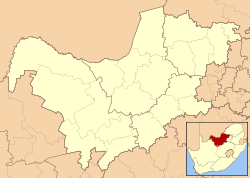
| Local municipality |
Mafikeng |
| Found by British |
1880s |
| Government |
| - Executive Mayor |
Cllr Mosa Sejosingoe |
| Elevation |
4,921 ft (1,500 m) |
| Population (2001) |
| - Total |
49,300 |
| Time zone |
SAST (UTC+2) |
| Website |
http://www.mafikeng.gov.za/ |
Mafikeng – formerly known as Mahikeng – is the capital city of the North-West Province of South Africa. Located on South Africa's border with Botswana, it is 1,400 km (870 mi) northeast of Cape Town and 260 km (160 mi) west of Johannesburg. In 2001, it had a population of 49,300. In 2007, Mafikeng was reported to have a population of 250,000 of which the CBD constitutes between 69,000 and 75,000. It is built on the open veld at an elevation of 1,500 m (4,921 ft), by the banks of the Upper Molopo River. The Madibi goldfields are some 15 km (9.3 mi) south of the town.
The city is known in history as Mafeking.
History
Mafikeng was originally headquarters of the Barolong people. The town was founded in the 1880s by British mercenaries granted land by a Barolong chief. The settlement was named Mafikeng, a Setswana name meaning "place of stones".[1] Later British settlers spelled the name as "Mafeking". It was from Pitsani Pothlugo (or Potlogo), 24 miles (39 km) north of Mafeking, that the Jameson Raid started, on December 29, 1895.
On the outbreak of the Second Boer War in 1899, the town was besieged. The Siege of Mafeking lasted 217 days from October 1899 to May 1900, and turned Robert Baden-Powell into a national hero. In September 1904, Lord Roberts unveiled an obelisk at Mafeking bearing the names of those who fell in defence of the town. In all, 212 people were killed during the siege, with more than 600 wounded. Boer losses were significantly higher.
Mafikeng served as capital of the Bechuanaland Protectorate, even though it was outside the protectorate's borders, from 1894 until 1965, when Gaborone was made the capital of what was to become Botswana.
Mafeking briefly served as capital of the pre-independence Bantustan of Bophuthatswana in the 1970s before the adjoining town of Mmabatho was established as capital. In 1980 the spelling Mafikeng was restored and following the end of apartheid in 1994, Mafikeng and Mmabatho were merged and made capital of the new North-West Province.
Climate
| Climate data for Mafikeng |
| Month |
Jan |
Feb |
Mar |
Apr |
May |
Jun |
Jul |
Aug |
Sep |
Oct |
Nov |
Dec |
Year |
| Source: South African Weather Service[2] |
| Mafikeng |
| Climate chart () |
| J |
F |
M |
A |
M |
J |
J |
A |
S |
O |
N |
D |
|
|
|
|
|
|
|
|
|
|
|
|
|
| average max. and min. temperatures in °C |
| precipitation totals in mm |
| source: SAWS[2] |
|
| Imperial conversion |
| J |
F |
M |
A |
M |
J |
J |
A |
S |
O |
N |
D |
|
|
|
|
|
|
|
|
|
|
|
|
|
| average max. and min. temperatures in °F |
| precipitation totals in inches |
|
Economy
Mafikeng has five shopping complexes, 11 banks and the head offices of many provincial institutions. The city lies some 280 km from Johannesburg.[3]
See also
References
External links
|
Province of North West, South Africa |
|
| Provincial Capital: Mafikeng |
|
| District Municipalities |
Bojanala Platinum · Ngaka Modiri Molema · Dr Ruth Segomotsi Mompati · Dr Kenneth Kaunda
|
|
| Smaller Cities |
Bloemhof · Blyvooruitzicht · Brits · Broederstroom · Christiana · Coligny · Delareyville · Derby · Freedom Park · Ga-Rankuwa · Groot Marico · Hartbeesfontein · Hartbeespoort · Klerksdorp · Kosmos · Koster · Kroondal · Leeudoringstad · Lichtenburg · Mabopane · Makwassie · Mmabatho · Mmakau · Moedwil · Orkney · Ottosdal · Phokeng · Pomfret · Potchefstroom · Ramatlabama · Ramokoka · Reivilo · Rustenburg · Sannieshof · Schweizer-Reneke · Stella · Stilfontein · Sun City · Swartruggens · Taung · Ventersdorp · Vryburg · Wolmaransstad · Zeerust · Zinniaville |
|