Mâcon
|
Mâcon |
|
 |
|
 Mâcon
|
|
|
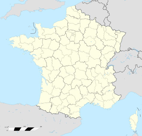
Location within Burgundy region
 Mâcon
|
|
| Administration | |
|---|---|
| Country | France |
| Region | Burgundy |
| Department | Saône-et-Loire |
| Arrondissement | Mâcon |
| Canton | Chef-lieu for 3 cantons (Mâcon-Centre, Mâcon-Nord and Mâcon-Sud) |
| Intercommunality | Mâconnais–Val de Saône |
| Mayor | Jean-Patrick Courtois] (2001–2014) |
| Statistics | |
| Elevation | 167–347 m (548–1,138 ft) (avg. 175 m/574 ft) |
| Land area1 | 27.04 km2 (10.44 sq mi) |
| Population2 | 35,393 (2006) |
| - Density | 1,309 /km2 (3,390 /sq mi) |
| INSEE/Postal code | 71270/ 71000 |
| Website | http://www.macon.fr/ |
| 1 French Land Register data, which excludes lakes, ponds, glaciers > 1 km² (0.386 sq mi or 247 acres) and river estuaries. | |
| 2 Population sans doubles comptes: residents of multiple communes (e.g., students and military personnel) only counted once. | |
Mâcon is a commune of France and prefecture of the Saône-et-Loire department, in the region of Bourgogne. It is the capital of the Mâconnais district. Inhabitants of Mâcon are called Mâconnais.
Geography
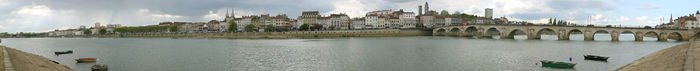
The city lies on the western bank of the Saône river, between Bresse in the East and the Beaujolais hills in the South. Mâcon is the southernmost city in the region of Burgundy, which gives it a southern flair with its Roman tile roofs and its colourful facades. It is located 65 kilometres north of Lyon and 400 kilometres from Paris.
The area of Mâcon is 27.04 km2 (16.8 sq mi) including 5.76km2 (3.58 sq mi) of green spaces .
Hydrography
The Saône river runs through the town.
History
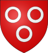
Mâcon’s Coat of arms has the heraldic definition: “Gules charged with three silver annulets”. This coat of arms is said to have been used since the Renaissance Period.
The agglomeration of Mâcon originates from the establishment of an oppidum and of a river port by the Celts from the Aedui, probably at the beginning of the first century BC. Known then under the name of Matisco, the town developed rapidly during the first two centuries of our era.
During the 4th century, the town was fortified.
During the Middle Ages, Mâcon was the administrative center of a county belonging to the Duchy of Burgundy, situated at the extremity of the bridge over the Saône leading to the Bresse territory belonging to the Duchy of Savoy. The town was controlling access to present-day Lamartinien Valley (Val Lamartinien), where the southern end of the Côte de Bourgogne joins the first foothills of the Beaujolais hills, opening the way to the rich plains of the Loire.
On 3 June 1564, Charles IXfrom Chalon, stopped in the town during his Royal Tour of France (1564–1566), accompanied by the Court and the nobles of his kingdom, including his brother the Duke of Anjou, Henry of Navarre, the cardinals of Bourbon and Lorraine.[1]. The town is strategically built: it was a possible entrance into the kingdom for the Swiss or German mercenaries during the French Wars of Religion. He was welcomed by the Queen Jeanne III of Navarre, nicknamed the “Queen of Protestants”, and 1,500 Huguenots.
The French Revolution and Empire
In 1790, the town became the chef-lieu of the newly created Saône-et-Loire department.
In 1814, the town was invaded by Austrian troops and then liberated twice by French troops before being permanently occupied until the fall of the Empire. After Napoléon’s return and the subsequent Hundred Days, Mâcon and the Mâconnais were again captured by the Austrians.
Second World War
During World War II, Mâcon was the first town in the unoccupied zone libre between Paris and Lyon. The town was liberated on 4 September by the troops who had landed in Provence[2].
Climate
The climate is temperate with a slight continental tendency.
Transport links
Mâcon is connected to neighbouring major cities through various routes:
- Roads:
- A6 motorway (Route: Paris-Lyon)
- A40 Motorway (route: Mâcon-Geneva)
- A406 Motorway (bypass south of Mâcon): This motorway is currently under construction
- Route nationale 6
- RCEA (Center-Europe-Atlantic road) which allows a direct traffic flow from Annemasse to Nantes or Bordeaux
- The François Mitterrand Bridge is the second work of construction connecting Mâcon to the left bank of the Saône River
- Railway Infrastructures:
- River infrastructures:
- The Saône riverwhich allows access to the Mediterranean Sea via the Rhône River
Public transport
City Transport
Mâcon uses the urban transport service Tréma, run by the organising transport authorities, the SITUM (Inter-communal City Transport Union of Mâconnais – Val de Saône). The SITUM currently consists of 3 members: CAMVAL (Agglomeration Community of Mâcon-Val de Saône) (26 communes) and the Chaintré and Crèches-sur-Saône communes. The Urban Transport Area of the SITUM extends over 28 communes in total.
On the evening of 30 June 2009, the Mâcon Bus services ceased operation. This was due to the public service delegation contract between the SITUM and the Mâcon Bus company (a subsidiary of Transdev), operating the network since 1987, not being renewed at the last call for bids. So since 1 July 2009, the company CarPostal Mâcon (CarPostal France's subsidiary) has been providing city transport services on the network renamed Tréma.
The network Tréma, restructured on 31 August 2009, made the following bid:
- urban lines (A to G) going through Mâcon, Crèches-sur-Saône, Sancé, Saint-Laurent-sur-Saône, central Charnay-lès-Mâcon and Mâcon-Loché TGV train station on a regular basis.
- a transport service requested by TrémA'Fil to operate in the other communes of the SITUM area, to increase the frequency of the less busy regular lines (F and G) and to offer a service for each city stop in the morning before the beginning of services for scheduled lines and in the evening after the end of the services.
- school lines named TrémA'Scol.
Inter-city departmental transport
Mâcon is run by the network Buscephale of Saône-et-Loire’s local council.
Administration
In 2010, the Mâcon commune was awarded the plaque "Ville Internet @@"[3].
Politics
| Period | Identity | Party | Position |
|---|---|---|---|
| March 1953 – March 1977 | Louis Escande | DVD | . |
| March 1977– March 2001 | Michel Antoine Rognard | PS | |
| mars 2001– | Jean-Patrick Courtois | UMP | Senator |
Education
Mâcon has five collèges and four lycées. These establishments are located in the same area in the west of the city, with the exception of the collèges Schuman (north) and Saint-Exupery (south). Collèges Collège Louis Pasteur Collège Bréart Collège Schuman Collège Saint-Exupéry Collège Notre-Dame (private) Lycées Lycée Lamartine Lycée René-Cassin Lycée hôtelier Dumaine Lycée Ozanam (private)
Cooperation between municipalities
Mâcon is a member of CAMVAL (agglomeration community of the Mâconnais – Val de Saône districts). It is also where the CAMVAL headquarters is located.
Demography
|
|||||||||||||||||||||||||||
|
|||||||||||||||||||||||||||
|
|||||||||||||||||||||||||||
|
|||||||||||||||||||||||||||
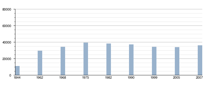
- Urban population (2006):61,641 (CAMVAL)
- Wider urban area population: 104,000
The influence of Mâcon seems to have grown. It is one of the department’s major employment areas which is by far the most dynamic (13.5% increase between 1999 and 2006) compared to cities such as Chalon-sur-Saône or Montceau-les-Mines which are losing jobs. This dynamism is particularly helped by the many transportation links available and its proximity to Lyon.
It should be noted that the decline in the town’s population is much to the profit of a phenomenon of urban sprawl in the communes of the Mâconnais as well as the adjacent Ain. That is why the area of influence of Mâcon, the “Greater Mâcon”, focuses on three departments: the Saône-et-Loire, the Ain and the Rhône. Thus, among the 47 communes with fewer than 10,000 inhabitants in the urban area, 41 are currently growing and 6 are stable or in slight decline.
Associated districts and communes
Town center
.JPEG)
.JPG)
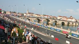
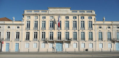
Mâcon’s town center of extends from Place Gardon, in the north, to the Roundabout of Europe in the south, from Place de la Barre, in the west, to the banks along the Saône in the east of the city. The center is the town’s shopping area. Most shops are located near the Town Hall (rue Carnot, rue Dufour, rue Sigorgne, rue Philibert-Laguiche, rue Dombert, rue Franche, the quay Lamartine, the esplanade Lamartine and rue de la Barre). It is also the historical center of the town. Most monuments are located in that area (Cathedral of Saint-Vincent, Church Saint Pierre...), as are the town’s two museums. The town center consists of several districts which are all rather different from each other. With its Place aux Herbes, the Saint-Antoine district is the historic heart of Mâcon, despite its relative distance from the Town Hall. This district covers the northern part of the town center; it is crossed by the rue de Strasbourg and consists of narrow lanes. There is the prefecture of Saône-et-Loire and the old Saint-Vincent Cathedral commonly called the Old Saint-Vincent. Further west lies the Square de la Paix, bordered by the Hôtel-Dieu, the Palais de Justice, Saint-Vincent Cathedral, plus the Vallon des Rigollettes and the Héritan district.
From the late 1990s to the early 2000s, the esplanade Lamartine underwent extensive redevelopment and upgrades. The winding car park and damaged cobblestones were replaced by an underground parking lot on three levels, a larger and brighter esplanade, bars, and a stage on the water (of the Saône river) which now accommodates all kinds of events, concerts and shows. The Statue Lamartine, which sits proudly on the esplanade, was completely renovated. Small gardens now brighten up the immense space that Mâcon’s Esplanade Lamartine occupies. All along, one can find an extract from the famous poem by Lamartine, “Le Lac”: "Time, halt in your flight... " engraved in the ground in silver letters.
North of Mâcon
The north of Mâcon is split, with the Neusdadt roundabout marking the boundary between the two sections. Flacé-lès-Mâcon, a village built in the city, constitutes the north-west of Mâcon. . In addition to the adjoining Town Hall, church and small downtown area, Flacé consists entirely of residential areas.
The north-east of Mâcon is composed of various residential areas and the town’s sport centres (Physical Activity Training Course (P.A.P.A), public swimming pool, Center for Sports Education, rowing, sailing and water skiing clubs, several football fields and clubs, and the Sports Palace). ). The residential areas consist mainly of low-rent council estates ( HLM) with districts such as the priority development areas (ZUP) of Mâcon or the boulevard des États-Unis (road belonging administratively to the Saugeraies district).
South of Mâcon
The south of Mâcon is composed of three major areas.
- The first area is the Saint-Clément/Les Blanchettes block, also called Percée Sud. Saint-Clément only accounts for a small area but it is southern Mâcon’s main business area with the Europe roundabout. Les Blanchettes is a district of low-rent council estates (HLM) passing through Édouard-Herriot Avenue. It is a very woody area, which includes most notably the Parc des Allumettes and its numerous games for children. The Romanesque church is situated in Saint-Clément, bearing the name of this town.
- The second area is the largest in this part of the town; it is the industrial area south of Mâcon (the largest metropolitan area) which is composed of the Port River at Mâcon (6 in France).
- The third and final area in the south of Mâcon is the Chanaye / Fontenailles and is located southwest of the town. Fontenailles is a residential area consisting of detached houses. La Chanaye (pronounced "Chanai") is an area of low-rent council estates (HLM) bordered by the greenhouses of Mâcon. This district, along with the Boulevard des États-Unis and priority development areas (ZUP) of Mâcon, belongs to the sensitive urban zones (French ZUS).
West of Mâcon
The west of Mâcon is the least populated part of the town.
This is where Mâcon’s lycées (René Cassin, Lamartine, Alexandre Dumaine and Ozanam) and most of the collèges are located, along with some residential areas merged with those of Charnay-lès-Mâcon, the Hospital of Mâcon and the historic working class area of Mâcon,Bioux.
Flacé
Formerly an independent commune, Flacé-lès-Mâcon was re-attached to Mâcon in 1965. It is now a residential area with a very prominent village atmosphere.
Associated communes
Loché
Loché is an associated commune of Mâcon. The fusion-association dates from 1972. Mâcon-Loché-TGV station is located in this wine- producing village.
Saint-Jean-le-Priche
Saint-Jean-le-Priche is an associated commune of Mâcon. The merging association dates from 1972.
Sennecé-lès-Mâcon
Sennecé-lès-Mâcon is an associated commune of Mâcon. The merging association dates from 1972.
Urbanism
On Sunday 28 June 2009, three buildings in the Marbé district were destroyed by an implosion.[6].
Wine
The area west and north of Mâcon produces well-known wines from the Chardonnay grape. The best known appellation of the Mâconnais is Pouilly-Fuissé.
Economy
- Viticulture and maturing;
- Industrial River Port;
- Metallurgy ;
- Logistics and road transport;
- Boating.
Mâcon holds the headquarters of the Chamber of Commerce and Industry of Saône-et-Loire, which manages the river port of Mâcon through Aproport, the Automotive Training Center (CFA Automobile) and the Macon-Charnay airport. The headquarters for the Chamber of Agriculture of Saône-et-Loire is also based in Mâcon.
Sports and leisure
Mâcon has 73 clubs with 55 organisations, 40 different sports to play, and 14,506 members of a sports association (42% of the population). It was elected the most sportive town in France in 2001.
- The A.S Mâcon rugby club is now progressing to ‘Fédérale 2’ (the fourth division in the rugby union club championship). They reached the highest level in 1987–1988 (ASM appeared in the Pool league with Biarritz Olympique’s Serge Blanco, the US Dax, Montpellier Hérault RC Montpellier and Lavelanet).
- The rowing club (the Régates Mâconnaises) is a leading sport clubs in the town. Each year it organises several major events (regional, national championships) and sends many of its rowers to the biggest competitions. Similarly, each year, the Stade Nautique Mâconnais sends swimmers to the France N1 swimming championships.
- A motor boating Grand Prix is held annually in late September (part of the speed championship of France in categories S2000 and S3000).
- The Municipal Band of Mâcon.
- The Mâcon Academy is extensive and nationally recognised.
- Ski club and barefoot in Mâcon
Notable people
- Claude-Philibert Barthelot de Rambuteau (1781–1869), politician
- Pierre Batilliat, chemist and winemaker
- Antoine Bauderon de Sénecé (1643–1737), poet
- Jacques Bayardon (1934–1999), rugby player
- Pierre Boitard (1789–1859), botanist and geologist
- Loïc Chavériat (1977–), football player
- Jean-Baptiste Debrun (1750–1831), serviceman
- André Déléage (1903–1944), historian focusing on ancient civilisations and the Middle Ages, resistance fighter
- Paul Devinat (1890–1980), politician
- Alain Digbeu (1975–), basket-ball player
- Joseph Dombey (1742–1794), naturalist
- Jean-Baptiste Drouet (1763–1824), revolutionary who died in Mâcon
- Georges Duby (1919–1996), historian
- Jean Gontard, clown, who was born in Mâcon on 1 January 1807
- Jean-Claude Goyon (1937–), Egyptologist
- Samuel Guichenon]] (1607–1664), lawyer, historiographer and genealogist
- Henri Guillemin (1903–1992), historian
- Frédéric Jay (1976–), football player
- Florent-Alexandre-Melchior de La Baume (1736–1794), last count of Montrevel
- Alfred Lacroix (1863–1948), geologist and mineralogist
- Victor Amédée de La Fage (1750–1809), revolutionary
- Alphonse de Lamartine, , French poet, writer and politician born in Mâcon on 21October 1790
- Georges Lecomte (1867–1958), writer
- Maurice Lenormand (1913–2006), politician
- Le père Liochon, a grocer discovered on French television show Le Petit Rapporteur, who is paid tribute in a mural fresco
- Jimmy Mainfroi (1983–), football player
- Hugues Martin(1942–), politician
- Joseph Monet and Adrien Goyon, founders of the Monet-Goyon brand of motorcycles and velocimanes (a tricycle for disabled war veterans and physically-handicapped) in 1917
- Mgr Gabriel Piguet (1887–1952), ), later, bishop of Clermont-Ferrand and Righteous Among the Nations
- Claude Roberjot (1752–1799), politician
- Henry Testot-Ferry, discoverer of the prehistoric site of Roche de Solutré and tenured lecturer at the Mâcon Academy
- Roland Vieira (1979–), football player
- Jean-Claude Villain (1947–), poet
- Gérard Voisin (1945–), homme politique
- Jaouad Zairi (1982–), football player
- Emile-Edouard Chane dit Violet (1880–1955), actor and director
Monuments and tourist attractions
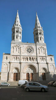
- The Old Saint-Vincent in the town centre
- Mâcon Cathedral (Cathédrale Saint-Vincent de Mâcon) in the town centre
- Museum of Fine Arts (former Ursuline Convent)
- Museum of Fine Arts (former Ursuline Convent)
- Hôtel de Senecé (Lamartine museum)
- Saint-Clément Catholic Church in the district of Saint-Clément
- Church Saint-Pierre, Place Saint-Pierre, opposite the Town Hall
- The Municipal Olympic Pool of Mâcon
- The Maison des Vins or Maison Maconnaise des Vins, located on De-Lattre de Tassigny Avenue.
- The Quai Lamartine (quay), the Vallon des Rigollettes, the Physical Activity Training Course (P.A.P.A) and the Marina: many places suitable for walking and relaxing.
- The Theater of Mâcon (public theatre) is located not far from the Maison des vins on the Droits de l'Homme esplanade.
- Château Saint-Jean, located in the old commune of Saint-Jean-le-Priche annexed to Mâcon in 1972
- Château des Perrières, on a hill overlooking the town
Parks and gardens
In 2007, the city was awarded the Grand Prix prize and “4 flowers” in the Entente Florale competition[7].
Mosque
- Islamic Cultural Association in Macôn, rue Olivier de Serres.
- Turkish Cultural Center of Mâcon, Fontenaille.
- Great Mosque in construction work to be finished for summer 2010
In popular culture
- The Baby of Mâcon is a 1993 film directed by Peter Greenaway.
- Mâcon is the hometown of petulant waitress Jessica (Cécile de France) in Avenue Montaigne, Danièle Thompson's 2006 film.
Twin towns
 Neustadt an der Weinstrasse, Germany, since 26 June 1956
 Crewe and Nantwich, United Kingdom, since 1957
.svg.png) Overijse, Belgium, since 28 August 1960
Overijse, Belgium, since 28 August 1960 Macon, United States, since 1972
 Shumen, Bulgaria, since 18 September 2006
 Lecco, Italy, since 12 May 1973
 Alcazar de San Juan, Spain, since 15 March 1980
 Eger, Hungary, since 11 May 1985
 Pori, Finland, since 11 May 1990
 Santo Tirso, Portugal, since 20 June 1992
Culinary specialties
- Mâcon's specialty is a cake made of meringue and filled with butter cream.
- Mâcon is surrounded by a vineyard of 12,355 acres which produces 49 million bottles of wine including the famous crus like Saint-Véran or Pouilly-fuissé.
- West of Mâcon, there is the Charolais area famous for its white-coated cattle.
- East of Mâcon, on the other side of the Saône river, there is Bresse, famous for its white poultry, the only ones to have received an Appellation d'Origine Contrôlée (AOC) stamp.
Notes and references
Bibliography
- Pierre Goujon (éd.), Histoire de Mâcon, Toulouse, 2000. It consists of:
- Jean Combier, « De la préhistoire aux Burgondes », p. 17–44
- Alain Guerreau, « Mâcon, 380–1239 : la cité épiscopale », p. 45–79
- Isabelle Vernus, « Prospérités et affrontements, 1239–1600 », p. 81–112
- Christine Lamarre, « De l'époque classique aux transformations révolutionnaires. La ville classique des XVIIme et XVIIIme siècles », p. 113–139
- Jean-François Garmier, « L'Essor et les transformations de la ville (17me – 19me siècles) », p. 141–154
- Pierre Lévêque, « Au temps de Lamartine », p. 155–196
- Pierre Goujon, « Mâcon dans la deuxième moitié du 19me siècle : une ville en symbiose avec sa région », p. 197–238
- Lucien Delpeuch, « Une ville moyenne face aux défis du 20me siècle : Mâcon de 1914 à 1945 », p. 219–263
- Annie Bleton-Ruget et Nicole Commerçon, « Mâcon, une ville moyenne ordinaire ? », p. 265–300.
See also
- Ancient Diocese of Mâcon
- Burgundy wine
- Communes of the Saône-et-Loire department
References
- Notes
- ↑ , p 253
- ↑ Stéphane Simonnet, Atlas de la Libération de la France, ed. Autrement, Paris, 1994, reissued. 2004 (ISBN 2-7467-0495-1), p 63, p. 35
- ↑ Palmarès 2010 des Villes Internet sur le site officiel de l'association. Consulté le 19/12/2009.
- ↑ "http://cassini.ehess.fr/ Population par commune avant 1962 (résultats publiés au journal officiel ou conservés aux archives départementales)". Cassini.ehess.fr. http://cassini.ehess.fr/cassini/fr/html/6_index.htm. Retrieved 29 August 2010.
- ↑ "INSEE : Population depuis le recensement de 1962". Insee.fr. http://www.insee.fr/fr/ffc/docs_ffc/psdc.htm. Retrieved 29 August 2010.
- ↑ "rénovation urbaine de Marbé sur". Macon.fr. http://www.macon.fr/?page=news&type_news=actualite&id=95. Retrieved 29 August 2010.
- ↑ Source : Villes et Villages Fleuris
External links
- City council website and mirror site (in French)
- Tourist office website
- Virtual visit
- Mâcon library (in French)
|
|||||