Petropavlovsk-Kamchatsky
| Petropavlovsk-Kamchatsky (English) Петропавловск-Камчатский (Russian) |
|
|---|---|
| — Inhabited locality — | |
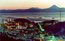 Petropavlovsk-Kamchatsky at night |
|
 Petropavlovsk-Kamchatsky
|
|
| Coordinates: | |
 |
.png) |
| Holiday | October 17 |
| Administrative status | |
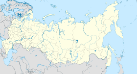
| Country | Russia |
| Federal subject | Kamchatka Krai |
| Administrative center of | Kamchatka Krai |
| Municipal status | |
| Urban okrug | Petropavlovsk-Kamchatsky Urban Okrug |
| Head | Vladislav Skvortsov |
| Representative body | City Duma |
| Statistics | |
| Area | 400 km2 (150 sq mi) |
| Population (2002 Census) | 198,028 inhabitants[1] |
| - Rank | 93rd |
| - Density | 495 /km2 (1,280 /sq mi)[2] |
| Time zone | MAGT/MAGST (UTC+11/+12)[3] |
| Founded | October 17, 1740 |
| Previous names | Petropavlovsk (until 1924) |
| Postal code(s) | 683000 (main) |
| Dialing code(s) | +7 4152 |
| Official website | |
Petropavlovsk-Kamchatsky (Russian: Петропа́вловск-Камча́тский) is the main city and the administrative, industrial, scientific, and cultural center of Kamchatka Krai (Russia). Population: 198,028 (2002 Census);[1] 268,747 (1989 Census).[4].
Contents |
Geography
The city is situated on high hills and surrounded by volcanoes. In fact, the horizon cannot be seen clearly from any point in town as volcanoes and mountains are everywhere. Across Avacha Bay from the city is Russia's largest submarine base, the Rybachiy Nuclear Submarine Base, (location and satellite photos: ) established during Soviet times and still used by the Russian Navy. [3] The city is located 6766 km (4204 miles) from Moscow, about 9 hours by plane.
History
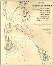
Petropavlovsk was founded by Danish navigator Vitus Bering, in the service of the Russian Navy. Bering reached Avacha Bay on July 10, 1740 and laid the foundation stone for the harbor town, naming the new settlement "Petropavlovsk" (Peter + Paul) after his two ships, the St. Peter and the St. Paul, built in Okhotsk for his second expedition. The town's location on the sheltered Avacha Bay and at the mouth of the Avacha River saw it develop to become the most important settlement in Kamchatka. It was granted town status on April 9, 1812.
During the 1854–1855 Crimean War, the city was put under siege by the Anglo-French forces, but never fell. The city had been fortified under the command of Nikolay Muravyov-Amursky in the years previous, but only possessed a small garrison of a few hundred soldiers and 67 cannons. After much exchange of fire, 600 allied troops landed south of the city, but were forced to retreat by only 230 Russian troops after heavy fighting. One week later, 900 allied troops landed east of the town, but were again repelled by the Russians. The allied ships then retreated from Russian waters. The total Russian losses were reported at around 100 men, those of the allies at least five times that number.
Petropavlovsk was a great source of fish, particularly salmon, and crab meat for the Soviet Union in the 20th century. Since the end of the Soviet era fishing rights have also been granted to foreign interests.
Tourism
The city has developed a tourist infrastructure. About twenty large tourism companies offer a wide range of services from bear hunting to paragliding. No roads connect the Kamchatka Peninsula to the rest of the world. Travel to Petropavlovsk-Kamchatsky is expensive but is growing in popularity because of the remarkable scenery throughout the peninsula. The city is served by Petropavlovsk-Kamchatsky Airport.
Demographics
Ethnic Russians and Ukrainians make up the majority of the population; the city on its own has more inhabitants than the entire neighboring Chukotka Autonomous Okrug or Magadan Oblast.
Climate
Petropavlovsk-Kamchatsky has a Continental climate which borders on subarctic and precipitation averages are estimated at 860 millimeters (33.9 in), or about three times as much as average in Siberia, with most falling as snow. Temperatures in winter are milder than in Siberia—a typical January day averages −7.3 °C (18.9 °F), while in summer 15 °C (59 °F) constitutes an average August maximum.
| Climate data for Petropavlovsk-Kamchatsky, Kamchatka Krai | |||||||||||||
|---|---|---|---|---|---|---|---|---|---|---|---|---|---|
| Month | Jan | Feb | Mar | Apr | May | Jun | Jul | Aug | Sep | Oct | Nov | Dec | Year |
| Record high °C (°F) | 4.4 (39.9) |
3.6 (38.5) |
6.8 (44.2) |
18.1 (64.6) |
20.6 (69.1) |
27.6 (81.7) |
29.4 (84.9) |
27.2 (81) |
24.4 (75.9) |
17.8 (64) |
12.6 (54.7) |
6.1 (43) |
29.4 (84.9) |
| Average high °C (°F) | -5.9 (21.4) |
-5.0 (23) |
-2.8 (27) |
0.9 (33.6) |
5.6 (42.1) |
10.8 (51.4) |
13.9 (57) |
15.0 (59) |
12.4 (54.3) |
7.2 (45) |
0.3 (32.5) |
-4.0 (24.8) |
4.1 (39.4) |
| Average low °C (°F) | -10.6 (12.9) |
-10.0 (14) |
-7.9 (17.8) |
-3.3 (26.1) |
0.7 (33.3) |
5.0 (41) |
8.7 (47.7) |
9.6 (49.3) |
6.5 (43.7) |
2.1 (35.8) |
-4.4 (24.1) |
-8.4 (16.9) |
-0.9 (30.4) |
| Record low °C (°F) | -28.6 (-19.5) |
-31.7 (-25.1) |
-24.8 (-12.6) |
-14.8 (5.4) |
-10.0 (14) |
-5.5 (22.1) |
0.1 (32.2) |
0.2 (32.4) |
-3.2 (26.2) |
-8.6 (16.5) |
-16.5 (2.3) |
-26.0 (-14.8) |
-31.7 (-25.1) |
| Precipitation mm (inches) | 69 (2.72) |
59 (2.32) |
52 (2.05) |
53 (2.09) |
49 (1.93) |
57 (2.24) |
75 (2.95) |
99 (3.9) |
100 (3.94) |
133 (5.24) |
81 (3.19) |
98 (3.86) |
895 (35.24) |
| Source: Погода и климат [5] | |||||||||||||
International relations
Twin towns — Sister cities
Petropavlovsk-Kamchatsky is twinned with:
 Kushiro City, Japan (since 1998).[6]
 Sevastopol, Ukraine (since 2009).[7]
 Unalaska, United States (since 1990).[8]
See also
- Russian Pacific Fleet
References
- ↑ 1.0 1.1 Федеральная служба государственной статистики (Federal State Statistics Service) (2004-05-21). "Численность населения России, субъектов Российской Федерации в составе федеральных округов, районов, городских поселений, сельских населённых пунктов – районных центров и сельских населённых пунктов с населением 3 тысячи и более человек (Population of Russia, its federal districts, federal subjects, districts, urban localities, rural localities—administrative centers, and rural localities with population of over 3,000)" (in Russian). Всероссийская перепись населения 2002 года (All-Russia Population Census of 2002). Federal State Statistics Service. http://perepis2002.ru/ct/html/TOM_01_04_1.htm. Retrieved 2009-08-19.
- ↑ The value of density was calculated automatically by dividing the 2002 Census population by the area specified in the infobox. Please note that this value may not be accurate as the area specified in the infobox does not necessarily correspond to the area of the entity proper or is reported for the same year as the Census (2002).
- ↑ Правительство Российской Федерации. Постановление №171 от 19 марта 2010 г. «О применении на территории Камчатского края и Чукотского автономного округа времени десятого часового пояса». Опубликован: "Российская Газета", №58, 22 марта 2010 г. (Government of the Russian Federation. Resolution #171 of March 19, 2010 On Using the Time of the Tenth Time Zone on the Territory of Kamchatka Krai and Chukotka Autonomous Okrug. ).
- ↑ "Всесоюзная перепись населения 1989 г. Численность наличного населения союзных и автономных республик, автономных областей и округов, краёв, областей, районов, городских поселений и сёл-райцентров. (All Union Population Census of 1989. Present population of union and autonomous republics, autonomous oblasts and okrugs, krais, oblasts, districts, urban settlements, and villages serving as district administrative centers.)" (in Russian). Всесоюзная перепись населения 1989 года (All-Union Population Census of 1989). Demoscope Weekly (website of the Institute of Demographics of the State University—Higher School of Economics. 1989. http://demoscope.ru/weekly/ssp/rus89_reg.php. Retrieved 2007-12-13.
- ↑ Погода и климат. [1]. . Retrieved on: April 8, 2010.
- ↑ Russian presence in Japan
- ↑ [2]
- ↑ Alaska - Kamchatka Connections
External links
- Community of Kamchatka (Russian)
- Photos of Kamchatka (Russian)
- News of Petropavlovsk-Kamchatsky and Kamchatka krai (Russian)
- Daily updated news and photos of Petropavlovsk-Kamchatsky (Russian)
- Petropavlovsk-Kamchatsky Internet portal (Russian)
- History of the city Petropavlovsk-Kamchatsky (Russian)
- FotoPetropavlovsk.ru — photographies of the city Petropavlovsk-Kamchatsky (Russian)
- Petropavlovsk-Kamchatsky city sceneries (English)
Gallery
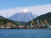 Petropavlovsk and Koryaksky Volcano, as seen from Avacha Bay |
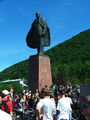 Lenin Square |
 View to Koryakskaya, October 2005 |
 Original town center |
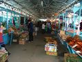 Central market |
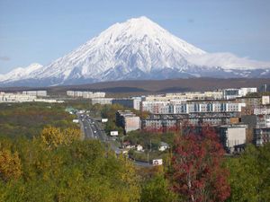
 The Avachinsky volcano from the city |
|
||||||||||||||
|
|||||||||||