Quetzaltenango
| Quetzaltenango Municipality Xelajú |
|
|---|---|
 |
|
| Nickname(s): Xela | |
| Motto: La ciudad de la Estrella | |
 Quetzaltenango Municipality
|
|
| Coordinates: | |
| Country | |
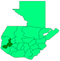
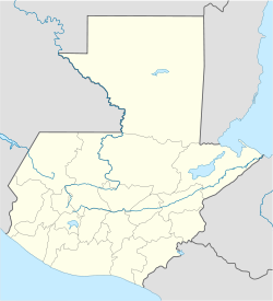
| Department | Quetzaltenango |
| Government | |
| - Mayor | Mito Barrientos, Grand National Alliance |
| Area | |
| - Total | 46.3 sq mi (120 km2) |
| Elevation | 7,733 ft (2,357 m) |
| Population | |
| - Total | 300,874 |
| - Ethnicities | K'iche', Mam, Ladino |
| - Religions | Roman Catholicism, Evangelicalism, Maya |
Quetzaltenango, also commonly known by its indigenous name, Xelajú (/ʃelaˈxu) or more commonly, Xela (/ˈʃela/) is the second most populous city of Guatemala[1], after Guatemala City. It is both the capital of Quetzaltenango Department and the municipal seat of Quetzaltenango municipality.
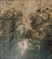
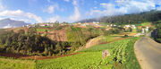
It has an estimated population of 300,000. The population is about 65% indigenous or Amerindian, 32% Mestizo or ladino, and 3% European. Quetzaltenango is located in a mountain valley at an elevation of 2,333 meters (7,655 ft) above sea level.
The Municipality of Xela (Quetzaltenango) consists of an area of 127 square kilometers. Municipalities abutting the Municipality of Xela include: Salcajá, Cantel, Almolonga, Zunil, El Palmar, Concepción Chiquirichapa, San Mateo, La Esperanza, Olintepeque, and San Andrés Xecul. All these municipalities are part of the Department of Quetzaltenango, except San Andrés Xecul which is part of the Department of Totonicapán.
Contents |
History
In Pre-Columbian times Quetzaltenango was a city of the Mam Maya people called Xelajú, although by the time of the Spanish Conquest it had become part of the K'iche' Kingdom of Q'umarkaj. The name may be derived from "Xe laju' noj" meaning "under ten mountains". The city was said to have already been over 300 years old when the Spanish first arrived. With the help of his allies, Conquistador Pedro de Alvarado defeated and killed the Maya ruler Tecún Umán here. When Alvarado conquered the city for Spain in the 1520s, he called it by the Nahuatl name used by his Central Mexican Indian allies, "Quetzaltenango", generally considered to mean "the place of the quetzal bird" (although see note on etymology below). Quetzaltenango became the city's official name in colonial times. However, many people (especially, but not only, the indigenous population) continue to call the city "Xelajú" (pronounced shay-lah-WHO) or more commonly Xela for short, and some proudly, but unofficially, consider it the "capital of the Mayas".
From 1838 to 1840 Quetzaltenango was capital of the state of Los Altos, one of the states or provinces of the Federal Republic of Central America. As the union broke up, the army of Guatemala under Rafael Carrera conquered Quetzaltenango making it again part of Guatemala.
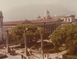
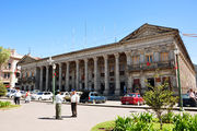
In the 19th century, coffee was introduced as a major crop in the area and the economy of Xela prospered. Much fine Belle Époque architecture can still be found in the city.
In 1930 the only electric railway in Guatemala, the Ferrocarril de los Altos, was inaugurated, which was later destroyed by mudslides and finally demolished in 1933. It had been built by AEG and Krupp and it consisted of 14 wagons. The track connected Quetzaltenango with San Felipe Retalhuleu. The people of Quetzaltenango are still very proud of their railway. A railway museum has been established in the city centre.
Quetzaltenango, is well known as "the city that is the soul of culture". There is numerous bands that play jazz, blues, native music and so forth. There are numerous artists that focus their work on painting, singing, sculpture and so on.
Xela, the center of Quetzaltenango is perhaps the most visited tourist destination in Guatemala besides Antigua Guatemala and Tikal in Peten, and preferred by many as the number one choice to learn Spanish.
Climate
There are two main seasons in Quetzaltenango: the rainy season, which generally runs from May through mid-November, and the dry season, which runs from December until May. During the rainy season, rain falls consistently, usually in the afternoons. During the dry season, the city frequently will not receive a single drop of rain for months on end. From December through February, the days are quite warm, but the temperature drops dramatically during the nights.
Sports
Quetzaltenango is home to the Club Xelajú MC soccer team. The team competes at Estadio Mario Camposeco which has a capacity of 13,500 and is the most successful non-capital team in the Liga Nacional de Guatemala. It is also home to a rugby team in the newly formed Guatemalan rugby union and has enjoyed moderate success in the competition.
Etymology
The original Nahuatl name was quetzaltenānco, quetzal-tenān-co, of which a likely etymology is:
- [erected]-[wall]-[place] roughly translated as "place where there are erected walls"
or
- [Quetzal bird]-[fortification]-[in the] roughly translated as "In the Quetzal fortress"
(Note that while quetzalli also means feather of the quetzal bird it also means something erected, and it became associated with quetzal feathers because those were the kind of feathers that Mesoamerican rulers used in their erect head-dresses.)
Transportation
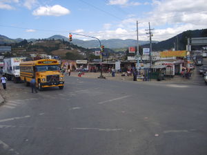
- The city boasts a system of micro-buses for quick and cheap movement within the city. A micro-bus is essentially a large van stuffed with seats. Micro-buses are numbered based on the route they take through the city (i.e. "ruta 7").
- There is no government-run mass transport system in the city. The sole public mean of transport within the city is the bus or system of micro-buses.
- Transportation to other cities in the country is provided by bus.
- Bicycling is a great way to get around the city, and also to travel to (and in) rural areas around the city.
- Quetzaltenango is about 200 km from Guatemala City.[2]
- Quetzaltenango Airport is currently undergoing expansion. Transportes Aereos Guatemaltecos offers charter flights to Guatemala City.
Sons and daughters of the city
- Jacobo Arbenz Guzmán, President of Guatemala, born in Xelajú in 1913.
- Comandante Rolando Morán, one of the guerrilla leaders in Guatemalan Civil War, born there in 1929.
- Carlos Navarrete Cáceres (b. 1931), anthropologist and writer
- Juan Arturo Gutierrez, founder of international fast-food chain Pollo Campero
- Paco Pérez, Author of Luna de Xelajú
- Manuel Estrada Cabrera, Dictator
- Luis Rolando Ixquiac Xicara, Artist, born in 1947
Consular representations
References
See also
- Wikitravel article
- Entremundos. Directory of volunteer opportunties in Guatemala with focus on Quetzaltenango
- Manos De Colores: Educacion para desarollo social
- Luna de Xelajú
- 5ª. Compañía Bomberos Voluntarios
- Club Xelajú MC, pro football team
- History of Guatemala
- History of Central America
- Tromsø, Norway, Quetzaltenango's Twin city
- Livermore, California, also Quetzaltenango's Twin city
- Quetzaltenango Map
|
|||||||||||