Rosenheim
| Rosenheim | |
 |
|
 Rosenheim
|
|
| Coordinates | |
| Administration | |
| Country | Germany |
|---|---|
| State | Bavaria |
| Admin. region | Upper Bavaria |
| District | urban district |
| Mayor | Gabriele Bauer (CSU) |
| Basic statistics | |
| Area | 37.22 km2 (14.37 sq mi) |
| Elevation | 440–470 m (1,444–1,542 ft) |
| Population | 60,877 (31 December 2009)[1] |
| - Density | 1,636 /km2 (4,236 /sq mi) |
| Other information | |
| Time zone | CET/CEST (UTC+1/+2) |
| Licence plate | RO |
| Postal codes | 83001-83028 |
| Area code | 08031 |
| Website | rosenheim.de |
Rosenheim is a town in Bavaria (Germany) at the confluence of the rivers Inn and Mangfall. It is seat of administration of the district of Rosenheim, but is not a part of it.
Contents |
Geography
The population of the town proper is approximately 60,000 inhabitants with up to 125,000 in the surrounding area. Rosenheim is situated in the Upper-Bavarian Alpine Foothillsand, 450 meters (1470 ft) above sea level and covers an area of 37.52 km². The capital of Bavaria, Munich, is 52 km away in North-West direction from Rosenheim. It has a station at the junction of the Munich–Salzburg and the Munich–Innsbruck lines.
History and sights
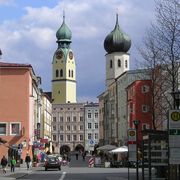
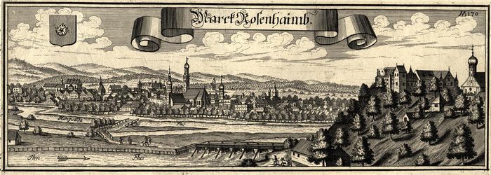
In 1234, Rosenheim was mentioned for the first time as a market. The town's landmark is the gothic spire (65 m) of the parish church St. Nikolaus (1450) with its baroque onion dome (1641).
Rosenheim has very good facilities for studies in the midst of excellent weather conditions. There is a Fachhochschule Rosenheim offering various courses to the students.
Famous people
- Nicholas McCarthy
- Siegfried Fischbacher
- Hermann Göring
- George Dzundza
- Nadine Samonte
- Hans-Ulrich Rudel
- Annemarie Schneider
- Bastian Schweinsteiger
- Edmund Stoiber
Famous neighbour cities
Twin cities
Rosenheim is twinned with:
Pictures
References
- ↑ "Fortschreibung des Bevölkerungsstandes" (in German). Bayerisches Landesamt für Statistik und Datenverarbeitung. 31 December 2009. https://www.statistikdaten.bayern.de/genesis/online/online?sequenz=statistiken&selectionname=12411.
External links
- Official Site (German)
- Fachhochschule Rosenheim (German)
- Out of Rosenheim
- Rosenheim Poltergeist
 Chisholm, Hugh, ed (1911). "Rosenheim". Encyclopædia Britannica (Eleventh ed.). Cambridge University Press.
|
||||||||
| This Rosenheim location article is a stub. You can help Wikipedia by expanding it. |