Rügen
 Rügen |
|
 Rügen (Germany)
|
|
| Geography | |
|---|---|
| Location | Baltic Sea |
| Area | 926.4 km2 (357.7 sq mi)[1] |
| Length | 51.4 km (31.94 mi) |
| Coastline | 574 km (356.7 mi) |
| Highest elevation | 161 m/528 ft[1] |
| Highest point | Piekberg[1] |
| Country | |
|
Germany
|
|
| State | |
| District | Rügen |
| Demographics | |
| Population | 77,000[1] (as of 2006) |
| Density | 79 /km2 (205 /sq mi) |
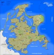
Rügen (German pronunciation: [ˈʁyːɡən]) or Rugia is Germany's largest island.[2] It is located in the Baltic Sea off the coast of Mecklenburg-Vorpommern. Rügen makes up the principal part of the Rügen District, which also includes the neighboring islands Hiddensee and Ummanz, as well as several small islands.
Contents |
Geography
Rügen is located in off the north-eastern coast of Germany in the Baltic Sea. The Rügendamm bridge which connects the island by road and rail with the city of Stralsund on the mainland crosses over the Strelasund.
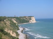
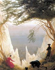
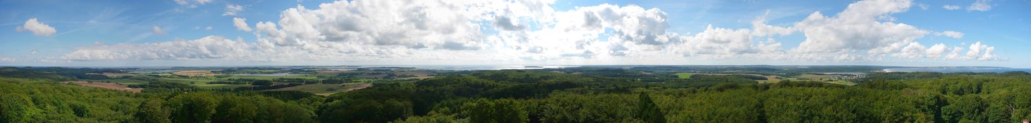
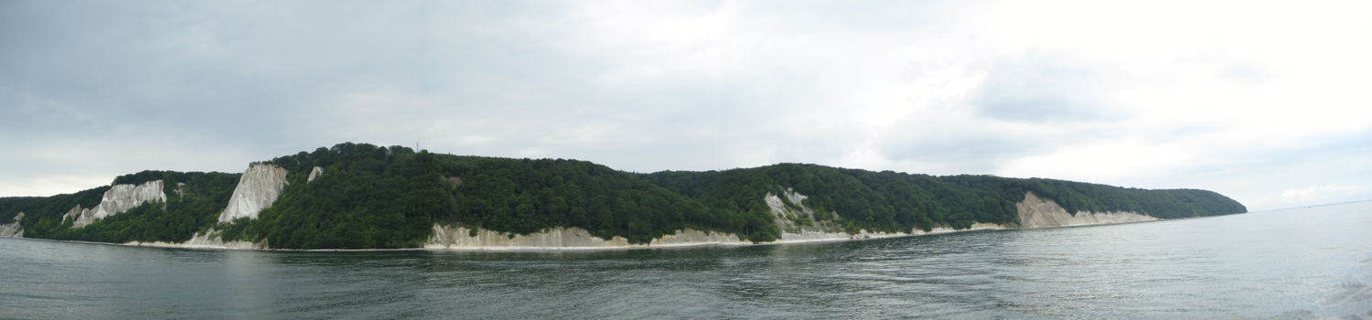
Rügen has an area of 926.4 km2, or 974 km2 if the adjacent small islands are included.[1] The maximum diameter is 51.4 km from north to south, and 42.8 km from east to west.[1] Of an overall 574 km-long coastline, 56 km are sandy Baltic Sea beaches, and 2.8 km sandy Bodden beaches.[1] The highest elevations are on the Jasmund peninsula: Piekberg (161 m) and Königsstuhl (117 m).[1]
The core landmass, Muttland, is surrounded by several peninsulas. To the north lie the peninsulas of Wittow and Jasmund, connected to each other by the Schaabe landbridge and to Muttland by the Schmale Heide landbridge, a dam at Lietzow and the Wittower Fähre ferry. The northern peninsulas are separated from Muttland by several Bodden, the largest of which are Großer Jasmunder Bodden and Kleiner Jasmunder Bodden. Major peninsulas in the south are Zudar and Mönchgut which both face the Bay of Greifswald.
The climate is in the temperate zone. The winters are not particularly cold, with mean temperatures in January and February of 0.0°C.; and summers are cool, with a mean temperature in August of 16.3°C. There is an average rainfall of 520–560 mm and approximately 1800–1870 hours of sunshine annually.
Two German national parks are situated on Rügen: Western Pomerania Lagoon Area National Park, in the West (also including Hiddensee), and Jasmund National Park, a smaller park including the famous chalk cliffs (Königsstuhl). There is also a nature reserve, Southeast Rügen Biosphere Reserve, consisting of the peninsulas in the southeast.
Administration
Rügen and the adjacent islands are administered as Landkreis Rügen (RÜG). Subordinate to the Landkreis are the Amt districts Amt Bergen auf Rügen (municipalities Bergen auf Rügen, Buschvitz, Garz, Gustow, Lietzow, Parchtitz, Patzig, Poseritz, Ralswiek, Rappin, Sehlen and Thesenvitz), Amt West-Rügen (municipalities Altefähr, Dreschvitz, Gingst, Hiddensee, Kluis, Neuenkirchen, Rambin, Samtens, Schaprode, Trent and Ummanz), Amt Nord-Rügen (municipalities Altenkirchen, Breege, Dranske, Glowe, Lohme, Putgarten, Sagard, Wiek) and Amt Mönchgut-Granitz (municipalities Baabe, Göhren, Lancken-Granitz, Middelhagen, Sellin, Thiessow and Zirkow) and the Amt-free municipalities of Binz, Putbus and Sassnitz.[3] Overall, there are 45 municipalities on Rügen, four of which have town status (Bergen, Garz, Putbus and Sassnitz).[4]
History
See also: Early history of Pomerania, Rugii, Rani (Slavic tribe), Principality of Rugia, Duchy of Pomerania, Swedish Pomerania, Province of Pomerania, Mecklenburg-Vorpommern
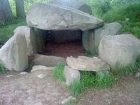
In the beginning of the first millennium, the island and the surrounding continental areas were settled by the Germanic Rugians after whom the island was named, who might have come from Scandinavia or evolved from autochthonous tribes. In the 7th century, West Slavic R(uj)ani settled Rügen, assimilating the Germanic population which had not migrated southward in the Migration Period. Many traces of their life can be found today. Rügen became a Slavic principality, stretching from the Recknitz to the Ryck River, with the political center in the ancient town of Charenza and a religious center in the fortified temple of Svantevit at Cape Arkona, the northernmost point of Rügen. In 1168 the area was conquered by Denmark and became the Danish Principality of Rugia. The principality underwent Christianisation and German settlement in the course of the Ostsiedlung. The former monarchs became Danish princes of Rügen. In 1325 Rügen was inherited by the Duchy of Pomerania.
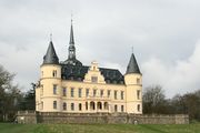
Rügen was a part of Swedish Pomerania from 1648 to 1815. Under Gustav IV Adolf of Sweden the town of Gustavia was constructed on the Mönchgut peninsula, but was abandoned during the Napoleonic Wars. Afterwards it became a part of the Prussian Province of Pomerania. In 1816 the first bathing resort was founded at Putbus. Later more resorts were established, and Rügen remained the most famous holiday resort of Germany until World War II. The Nazis added a large resort: Prora, planned by the Strength Through Joy organisation, which aimed to occupy people's free time. However, Prora was never completed.
In 1936 the first bridge connecting Rügen with the mainland was constructed (Rügendamm), replacing the former ferry shuttles. In 2007 a second bridge, Rügenbrücke, was built to replace the first. Rügen was a major summer holiday destination in the German Democratic Republic. Rügen remained a holiday island after German reunification; it has now surpassed Sylt as the most popular German island again.
In February 2006, dead swans found on Rügen tested positive for H5N1 (the avian influenza virus subtype that is a pandemic threat). A house cat was found dead with the H5N1 strain, marking the first known case of H5N1 in mammals in the European Union.
Tourist resorts
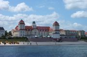
Rügen is one of the most visited holiday destinations in Germany. The first bathing facility on Rügen opened in 1794 at the mineral-rich spring in Sagard.[5] In 1818, Putbus' suburb Lauterbach became Rügen's first seaside resort.[6] In the 1860s Sassnitz became a seaside resort, followed by Binz in the 1880s.[6] During World War II Prora was constructed as a mass tourist resort but it was never finished.[6] Today the most popular seaside resorts are the Schaabe beaches between Altenkirchen and Juliusruh including Drewoldke, Glowe and Breege, and the eastern beaches between Sassnitz and Göhren including Neu Mukran, Prora, Binz, Sellin and Baabe. The latter are accessible via an historic narrow gauge railway employing steam locomotives, called Rügensche Bäderbahn. Tourist destinations other than seaside resorts include Cape Arkona, the wood-covered Stubbenkammer hills on Jasmund with interesting chalk cliff formations, the wood-covered Granitz hills with the Jagdschloß palace, and the inland places of Bergen auf Rügen, Ralswiek and Gingst.
The island offers a huge variety of different beach and shore areas. Rügen is often visited by windsurfers and kitesurfers and offers more than fifteen different locations for surfing. The most popular locations are Dranske, Rosengarten, Wiek, Suhrendorf and Neu Mukran.
Ferries
Sassnitz–Neu Mukran is the international ferry terminal on Rügen, with ferry services to
- Trelleborg (Sweden, served by Scandlines),[7]
- Rønne (Bornholm, Denmark, served by Bornholmstrafikken),[7]
- Klaipėda (Memel, Lithuania, served by DFDS Lisco),[7]
- Baltiysk (Pillau, Kaliningrad Oblast, Russia, served by DFDS Lisco),[7]
- Saint Petersburg (Russia, served by TransRussiaExpress)[7]
- Ust-Luga (near Saint Petersburg, Russia; planned).[8]
Sassnitz-Mukran is the largest railway ferry terminal in Germany and the only one in Europe where different tracks allow switching from standard gauge to broad gauge.[7]
Local passenger ferries connect the piers of Sassnitz, Binz, Sellin and Göhren with the adjacent islands of Hiddensee, Vilm and Greifswalder Oie. Passenger and car ferries connect Rügen's center of Muttland, to both Wittow in Rügen's north via the Wittower Fähre and to the mainland via the Glewitzer Fähre between Stahlbrode near Greifswald and Glewitz on Rügen's Zudar peninsula.
Trivia
The title given to the operation commanded by Wolfram von Richthofen, which saw the town of Guernica bombed during the Spanish Civil War, was named after the island. An Abwehr SIGINT Operation during the same conflict was titled Bodden after the strait separating Rügen from the German mainland.
See also
- List of islands in the Baltic Sea
- Bornholm
- Gotland, Öland
- Saaremaa, Hiiumaa
- Åland Islands
- Buyan
References
- ↑ 1.0 1.1 1.2 1.3 1.4 1.5 1.6 1.7 Wurlitzer, Bernd (2006) (in German). Rügen (11 ed.). Mair Dumont Marco Polo. p. 15. ISBN 3829701713.
- ↑ Jendricke, Bernhard; Gockel, Gabriele (2008) (in German). Rügen, Hiddensee (3 ed.). DuMont. p. 11. ISBN 3770160584.
- ↑ "Landkreis Rügen homepage/Regionales: Städte, Gemeinden, Ämter". http://www.kreis-rueg.de/. Retrieved 2009-08-24.
- ↑ Jendricke, Bernhard; Gockel, Gabriele (2008) (in German). Rügen, Hiddensee (3 ed.). DuMont. p. 13. ISBN 3770160584.
- ↑ Jendricke, Bernhard; Gockel, Gabriele (2008) (in German). Rügen, Hiddensee (3 ed.). DuMont. p. 36. ISBN 3770160584.
- ↑ 6.0 6.1 6.2 Küster, Hansjörg (2004) (in German). Die Ostsee: eine Natur- und Kulturgeschichte (2 ed.). C.H.Beck. p. 300. ISBN 3406523668.
- ↑ 7.0 7.1 7.2 7.3 7.4 7.5 "Fährhafen Sassnitz Gmbh (homepage), Verkehre, Liniendienste". http://www.faehrhafen-sassnitz.de/index-fl.htm. Retrieved 2009-08-24.
- ↑ "Deutsche Bahn Pressemitteilung vom 03.07.2009, 16:12". http://www.pressrelations.de/new/standard/result_main.cfm?r=374388&aktion=jour_pm. Retrieved 2009-08-24.
External links
 Media related to Rügen at Wikimedia Commons
 Chisholm, Hugh, ed (1911). "Rügen". Encyclopædia Britannica (Eleventh ed.). Cambridge University Press.
- Map of Rygensko by Ján Kollár
- Official site
- Chalk Cliffs of Rügen
|
|||||||
|
|||||||||||||||||||||||
|
||||||||||||||||||||||||||||||||||||||||||||
|
|||||||||||||||||||||||||||||||||||||||||||||||||||||||||||||||