Sargodha
| Sargodha سرگودھا City of Eagles |
|
|---|---|
 |
|
| Coordinates: | |
| Country | |
| Province | Punjab |
| District | Sargodha |
| Government | |
| - Administrator | |
| Area | |
| - Total | 5,854 km2 (2,260.2 sq mi) |
| Population | 2,666,000 |
| - Density | 455/km2 (1,178.4/sq mi) |
| Time zone | PST (UTC+5) |
| Calling code | 048 |
| Number of towns7 | |
| Number of Union councils | 22 |
Sargodha (Urdu: سرگودھا) is a city in the Sargodha District of Punjab province, Pakistan.
Sargodha is located in the northeast of Pakistan. It is the eleventh largest city of Pakistan and also known as Pakistan's best citrus-producing area. It is an agricultural trade centre with various industries.[1] Sargodha is one of three planned cities in Pakistan, the other two are Faisalabad and Islamabad.
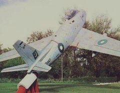
Pakistan's largest Airbase, PAF Base Mushaf (formerly PAF Base Sargodha), is situated in Sarghoda and hosts the headquarters of the Pakistan Air Force's Central Air Command. The airbase is also home to the Combat Commanders School (CCS), formerly the Fighter Leader's School, an elite training facility for training Pakistan Air Force pilots in fighter tactics and weapons.
Contents |
History
The term Sargodha has its origins in the words Sar, meaning pond, and Godha, meaning sadhu.[2][3]
Sargodha was a small town at the beginning of the British Empire but, due to its geographical location, the British Royal Air Force built an airport there. It took on greater importance after the Independence of Pakistan for the Pakistan Air Force. Shahpur, which is now a tehsil of Sargodha District, was the district at that time. Most parts of the tehsil Sillanwali and Kirana Hills region were part of Jhang district and were included later during the British Raj in the Sargodha district.
The 1965 war with India on September 6, 1965 meant the city was a prime target for India, due to the city's close proximity to the neighbouring rival. The citizens of Sargodha supported the Pakistan Army against the advancing of the Indian Army into Pakistan. In 1966, recognising this bravery, the Government of Pakistan awarded the city of Sargodha as well as Sialkot and Lahore with the award of Hilal-E-Istaqlal. The city also has a Pakistan Air Force base within its city. The PAF Base Sargodha now known as PAF Base Mushaf, named after the late Air Chief Marshal Mushaf Ali Mir, a former Chief of Air Staff of the Pakistan Air Force. The strategic location of the base has allowed the Air Force to carry out experimental work within the city. Sial Shareef is the most famous and blessed place of Sargogha. People all over the country and world come to Sial Shareef to gain spiritual education and for religious education. Khawja Muhammad Qamar Ud Din Sialvi was a the greatest saint, religious scholar of Sial Shareef (Sargodha). He took an active part in movement of Muslim League to gain Pakistan. He was entitled Sheikh Ul Islam by Govt. of Pakistan.
The city of Sargodha was awarded with the name of city of eagles
Demography
According to the 1998 census of Pakistan the district had a population of 2,665,979 of which 27.96% lived in urban settlements.[4]
Geography and climate
It is located 172 kilometres northwest of Lahore, in Sargodha District. It lies about 30 miles from the M2 Motorway which connects Lahore and Islamabad. it is connected to motorway M2 by several interchanges at different locations. Sargodha is roughly 60 km from Faisalabad due South east. Directly east connected by the M2 motorway is Lahore and the route to Rawalpindi and Islamabad. Due east is the city of Jhang and towards the west the city of Mianwali and the Chashma Barrage. Dera Ismail Khan is located 50 km from the city and towards the south west region from the city.
Sargodha mainly comprises flat fertile plains, which are the ideal conditions for cultivation of the land. There are a few small hills on Sargodha - Faisalabad Road. River Jhelum flows on the Western and Northern sides and river Chenab on the eastern side of the city. The city has extreme hot and cold climate. The maximum temperature touches 50C in the summer while the minimum temperature recorded is as low as freezing point in the winter. poetry by Dr Alama Iqbal in JAVED NAMA [[File:Example.jpgGAR CHE QAHATH-UR-RIJAAL BIAYAD AZ EN SEY NAGEREE, AWAL AFGHAN,DOWUM KUMBOO, SEWAM KAMZARF KASHMIRI]]. KUMBOO ARE THE PEOPLE WHO LIVE IN THIS AREA POPULATED BY BRITISHERS TO HABITATE THE AREA, WITH GROUP OF ALL NATURE OF PEOPLES. SO HIGHLY UN RELIABLE PEOPLE
Government
Until divisions were abolished in the year 2000, Sargodha was also divisional headquarters of Sargodha Division. Sargodha is the district and tehsil capital - the city of Sargodha is administratively subdivided into 22 Union councils.[5] In October 2008, the division system in Punjab Province has been restored which meant Sargodha became the divsional headquarters of Sargodha District, Khushab District, Mianwali District and Bhakkar District.
Prominent Figures from Sargodha
Economy
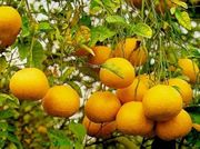
Sargodha is largey an agricultural and industrial city. The vast fields on the city have allowed the farmers to develop a range of crops and animal breeding programs. Some of the main crops include citrus, wheat, rice, and sugar cane which are exported to the other cities as well as internationally. Citrus fruits such as oranges (locally known as kinnows), Guavas and Mangoes are main fruits grown in the district. As well as Jaman, Pears, Dates, Pomegranate, Phalsa and Almond are also grown in minor quantities. Turnip, Onion, Cauliflower, Potatoes and Tomatoes are main vegetables grown in the district. The main livestock for the city include goats, sheep, buffaloes and cattle.
Even with agricultural goods being the major income generator for the city as well as the district, the economy and industry has been diversifying itself to generate more demand for other goods which can be manufactured and produced in the city. Other industrial markets include: Beverage, manufacture of diesel engines, foundry products, glass products, leather footwear, oil mills, pesticides, insecticides, poultry feed, plastics, readymade garments, tannery as well as textiles.
Education
Sargodha has several institutions of higher education and several research centres and Local Sargodha University:
- air base inter college sargodha
- PAF Public School Sargodha
- Sargodha Catholic High School
- Punjab College Sargodha
- University of Sargodha
- Sargodha Medical College, Sargodha
- Connoisseur Grammar School
- British Education Center PAF Sargodha
- Fazaia Inter College
- Army Public School and College Sargodha Cantt.
- Allama Iqbal Open University
- Al Suffah Girls College
- acme college sargodha
- Northwestern Theological Seminary
- Progressive Public School & College
- Superior College Sargodha
- The Punjab Girls High School
- Al suffah saviuor high school
- Beaconhouse School System
Govt.Polytechnic Insittute Sargodha Govt.College of Commerce Sargodha compre.hencive school< nst> comprehencive modle collage
- ILM college, boys & girls
- ITM college of commerc & science
- Dar-e-arqam schools & colleges
- Misali ravien science accadmy & high school
- comprehensive high school
- Nishan-e-Haider School Aziz Bhatti Town
- Zia Shams Ul Islam Sial Shareef
- [[Govt girls degree collage chak no 98 NB
Languages
Punjabi is the main language of the people. Urdu is also spoken. English is used in offices and used as one of the main educational language. Jhangochi lasani grammar high school sargotha
Media
- Bureau Office: Express News/The Daily Express/Express 24/7
- FM-96 Sunrise Pakistan
- Radio Pakistan Sargodha (FM 93 MHz)
- FM Bhalwal (FM 104 MHz)
- Pakistan Television
Sargodha at a Glance
| Sr.no | Detail | ||
|---|---|---|---|
| 1 | Population(0000)numbers | = | 2,666 |
| 2 | Area(square kilometer) | = | 5,854 |
| 3 | Population density (per km2.) | = | 455 |
| 4 | Tehsils | = | Sargodha,bhalwal,sahiwal,kotmomin,silanwali & shahpur. |
| 5 | Main towns | = | Bhera,Miani,Phularwan,Kotmomin,Lulliani,Maroolianwala,Farooqa & jhawrian,chak NO,46 S.B. |
| 6 | Main crops | = | Sugarcane,Wheat,Rice,Mize & Cotton. |
| 7 | Main Fruits | = | Citrus,Guavas & Mangoes. |
| 8 | Main Vegetables | = | Turnip,Onain,Cauliflower,Potatoes & Tomato. |
| 9 | Forest(Area in Acres) | = | 1,443 |
| 10 | Total Metlled Roads(Km) | = | 1,721 |
| 11 | No. of Grid Stations | = | 16 |
| 12 | No. of Telephone Exchanges | = | 42 |
| 13 | Major Industries | = | Beverage, Citrus Grading, Cotton Ginning & Pressing, Dairy Products, Bakelite, Diesel Engines, Electric Goods, Flour Mills, Fruit Juices, Fruit Preservation, General Engineering, Glass & Glass Products, Leather Footwear, Oil Mills, Packages, Pesticides / Insecticides, Poultry Feed, PVC Pipe, Readymade Garments, Sugar, Tannery, Textile Composite, Textile Spinning and Vegetable Ghee & Cooking Oil. |
See also
- Punjabi Saudagaran-e-Delhi
- PAF Base Mushaf
References
- ↑ Punjab Portal, Sargodha District population
- ↑ Pakistan tourism directory. Holiday Weekly. http://books.google.com/books?id=ZXuAAAAAMAAJ&q=Sargodha+Godha&dq=Sargodha+Godha&lr=&cd=5. Retrieved 2007-12-31. "Sargodha is a colony town established in 1903, but its origins are older. Sargodha is a combination of the words "Sar" meaning a pond and "Godha"..."
- ↑ Portrait of Pakistan. Ferozsons. http://books.google.com/books?id=b_1tAAAAMAAJ&q=Sargodha+Godha&dq=Sargodha+Godha&lr=&cd=17. Retrieved 2007-12-31. "The district derives its name for the headquarter town of Sargodha, which is a combination of "Sar" and "Godha". "Sar" is a hindi word which denotes a water..."
- ↑ Urban Resource Centre
- ↑ Tehsils & Unions in the District of Sargodha - Government of Pakistan
External links
- SargodhaPost.com - First Online Newspaper of Sargodha
- All about Sargodha
- Board of Intermediate and Secondary Education Sargodha
- University of Sargodha
|
|||||||||||||||||||||||||||||||||||||||||||||||||||||||||||||||||||||||||||||||||||||||||||||||||||||||||||||
|
||||||||||||||||||||||||||
|
|||||||||||||||||||||||||||||||||||||||||||||||||||||||||||||||||||||||||||||||||||||||||||||||||||||||||||||||||