Saskatchewan
| Saskatchewan |
|||||
|
|||||
| Motto: Latin: Multis e Gentibus Vires ("Strength from Many Peoples") |
|||||
 |
|||||
| Capital | Regina | ||||
|---|---|---|---|---|---|
| Largest city | Saskatoon | ||||
| Largest metro | Saskatoon | ||||
| Official languages | English (de facto) | ||||
| Demonym | Saskatchewanian, Saskatchewaner[1] | ||||
| Government | |||||
| Lieutenant-Governor | Gordon Barnhart | ||||
| Premier | Brad Wall (Saskatchewan Party) | ||||
| Federal representation | in Canadian Parliament | ||||
| House seats | 14 | ||||
| Senate seats | 6 | ||||
| Confederation | September 1, 1905 (Split from NWT) (8th province) | ||||
| Area | Ranked 7th | ||||
| Total | 651,900 km2 (251,700 sq mi) | ||||
| Land | 591,670 km2 (228,450 sq mi) | ||||
| Water (%) | 59,366 km2 (22,921 sq mi) (9.1%) | ||||
| Population | Ranked 6th | ||||
| Total (2010) | 1,041,729[2] | ||||
| Density | 1.67 /km2 (4.3 /sq mi) | ||||
| GDP | Ranked 6th | ||||
| Total (2006) | C$45.051 billion[3] | ||||
| Per capita | C$45,718 (5th) | ||||
| Abbreviations | |||||
| Postal | SK | ||||
| ISO 3166-2 | CA-SK | ||||
| Time zone | UTC−6 (no daylight saving time) Lloydminster and vicinity: UTC−7 and does observe DST | ||||
| Postal code prefix | S | ||||
| Flower | Western Red Lily | ||||
| Tree | Paper Birch | ||||
| Bird | Sharp-tailed Grouse | ||||
| Website | www.gov.sk.ca | ||||
| Rankings include all provinces and territories | |||||

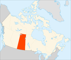
Saskatchewan /Saskatchewan.oggsəˈskætʃɪwɑːn/ is a prairie province in Canada, which has an area of 588,276 square kilometres (227,100 sq mi). Saskatchewan is bounded on the west by Alberta, on the north by the Northwest Territories, on the east by Manitoba, and on the south by the American states of Montana and North Dakota.
As of 2009, the population of Saskatchewan was estimated at 1,035,000 by the Canadian government. Residents primarily live in the southern half of the province. Of the total population, 257,300 live in the province's largest city, Saskatoon, while 194,971 live in the provincial capital, Regina. Other major cities include Prince Albert, Moose Jaw, Yorkton, Swift Current and North Battleford.[4]
Saskatchewan was first explored by Europeans in 1690 and settled in 1774; prior to that, it was populated by several indigenous tribes. It became a province in 1905. Saskatchewan's current premier is Brad Wall and its lieutenant-governor is Gordon Barnhart. Its major industries are agriculture, mining, and energy.
The province's name is derived from the Saskatchewan River. Earlier, the river was designated kisiskāciwani-sīpiy ("swift flowing river") in the Cree language.[5]
Contents |
Geography
Viewed from space, Saskatchewan appears to be a quadrilateral. However, because of its size, the 49th parallel boundary and the 60th northern border appear curved. Additionally, the eastern boundary of the province is partially crooked rather than following a line of longitude, as correction lines were devised by surveyors prior to the homestead program (1880–1928).
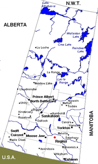
Saskatchewan is bounded on the west by Alberta, on the north by the Northwest Territories, on the east by Manitoba, and on the south by the American states of Montana and North Dakota. Saskatchewan has the distinction of being the only Canadian province for which no borders correspond to physical geographic features (i.e. they are parallels and meridians). Along with Alberta, Saskatchewan is one of two provinces that are land-locked.
The overwhelming majority of Saskatchewan's population is located in the southern third of the province, south of the 53rd parallel.
Saskatchewan contains two major natural regions: the Canadian Shield in the north and the Interior Plains in the south. Northern Saskatchewan is mostly covered by boreal forest except for the Lake Athabasca Sand Dunes, the largest active sand dunes in the world north of 58°, and adjacent to the southern shore of Lake Athabasca. Southern Saskatchewan contains another area with sand dunes known as the "Great Sand Hills" covering over 300 square kilometres (120 sq mi). The Cypress Hills, located in the southwestern corner of Saskatchewan and Killdeer Badlands (Grasslands National Park), are areas of the province that remained unglaciated during the last glaciation period.
The province's highest point, at 1,468 metres (4,816 ft), is located in the Cypress Hills and is the highest geographical point above sea-level between the Rocky Mountains and Québec. The lowest point is the shore of Lake Athabasca, at 213 metres (699 ft). The province has fourteen major drainage basins made up of various rivers and watersheds draining into the Arctic Ocean, Hudson Bay and the Gulf of Mexico.[6]
Climate
Saskatchewan lies far from any significant body of water. This fact, combined with its northerly latitude, gives it a warm summer version of humid continental climate (Köppen type Dfb) in the central and most of the eastern part as well as the Cypress Hills, drying off to a semi-arid steppe climate (Köppen type BSk) in the southern and southwestern part of the province. The northern parts of Saskatchewan — from about La Ronge northward — have a subarctic climate (Köppen Dfc). Summers can be very hot, with temperatures sometimes above 32 °C (90 °F) during the day, and humidity decreasing from northeast to southwest. Warm southern winds blow from the United States during much of July and August, while winters can be bitterly cold,[7] with high temperatures not breaking −17 °C (1.4 °F) for weeks at a time, warm chinook winds often blow from the west, bringing periods of mild weather. Annual precipitation averages 30 to 45 centimetres (12 to 18 inches) across the province, with the bulk of rain falling in June, July, and August.[8]
The hottest temperature ever recorded in Canada happened in Saskatchewan. The temperature rose to 45 degrees Celsius in Midale and Yellow Grass. The coldest ever recorded was -56.7 degrees Celsius in Prince Albert, which is north of Saskatoon.
| City | July (°C) | July (°F) | January (°C) | January (°F) |
|---|---|---|---|---|
| Estevan | 27/13 | 81/55 | -9/-20 | 16/-4 |
| Weyburn | 26/12 | 79/54 | -10/-21 | 14/-6 |
| Moose Jaw | 26/12 | 79/54 | -8/-19 | 18/-2 |
| Regina | 26/11 | 79/52 | -10/-22 | 14/-8 |
| Saskatoon | 25/11 | 77/52 | -12/-22 | 10/-8 |
| Melville | 25/11 | 77/52 | -12/-23 | 10/-9 |
| Swift Current | 25/11 | 77/52 | -7/-17 | 19/1 |
| Humboldt | 24/11 | 75/52 | -12/-23 | 10/-9 |
| Melfort | 24/11 | 75/52 | -14/-23 | 7/-9 |
| North Battleford | 24/11 | 75/52 | -12/-22 | 10/-8 |
| Yorkton | 24/11 | 75/52 | -13/-23 | 9/-9 |
| Lloydminster | 23/11 | 73/52 | -10/-19 | 14/-2 |
History
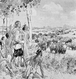
Prior to European settlement, Saskatchewan was populated by various indigenous peoples of North America, including members of the Athabaskan, Algonquian, Atsina, Cree, Saulteaux and Sioux tribes. The first European to enter Saskatchewan was Henry Kelsey in 1690, who travelled up the Saskatchewan River in hopes of trading fur with the province's indigenous peoples. The first permanent European settlement was a Hudson's Bay Company post at Cumberland House, founded in 1774 by Samuel Hearne.[10]
In 1803 the Louisiana Purchase transferred from France to the United States part of what is now Alberta and Saskatchewan. In 1818 it was ceded to the United Kingdom. Most of what is now Saskatchewan, though, was part of Rupert's Land and controlled by the Hudson's Bay Company, which claimed rights to all watersheds flowing into Hudson Bay, including the Saskatchewan, Churchill, Assiniboine, Souris, and Qu'Appelle River systems.
In the late 1850s and early 1860s, scientific expeditions led by John Palliser and Henry Youle Hind explored the prairie region of the province.
In 1870, Canada acquired the Hudson's Bay Company's territories and formed the North-West Territories to administer the vast territory between British Columbia and Manitoba. The Crown also entered into a series of numbered treaties with the indigenous peoples of the area, which serve as the basis of the relationship between First Nations, as they are called today, and the Crown.
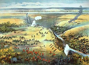
In 1885, post-Confederation Canada's first "naval battle" was fought in Saskatchewan, when a steamship engaged the Métis at Batoche in the North-West Rebellion.[11]
A seminal event in the history of what was to become Western Canada was the 1874 "March West" of the federal government's new North-West Mounted Police. Despite poor equipment and lack of provisions, the men on the march persevered and established a federal presence in the new territory. Historians have argued that had this expedition been unsuccessful, the expansionist United States would have been sorely tempted to expand into the political vacuum. And even had it not, then the construction of the Canadian Pacific Railway would have been delayed or taken a different, more northerly route, stunting the early growth of towns like Brandon, Regina, Medicine Hat and Calgary — had these existed at all. Failure to construct the railway could also have forced British Columbia to join the United States.
Settlement of the province started to take off as the Canadian Pacific Railway was built in the early 1880s, and the Canadian government divided up the land by the Dominion Land Survey and gave free land to any willing settlers.
The North-West Mounted Police set up several posts and forts across Saskatchewan including Fort Walsh in the Cypress Hills, and Wood Mountain Post in south-central Saskatchewan near the United States border.
In 1876, following the Battle of Little Bighorn Lakota, Chief Sitting Bull led several thousand of his people to Wood Mountain. Wood Mountain Reserve was founded in 1914.
Many Métis people, who had not been signatories to a treaty, had moved to the Southbranch Settlement and Prince Albert district north of present-day Saskatoon following the Red River Resistance in Manitoba in 1870. In the early 1880s, the Canadian government refused to hear the Métis' grievances, which stemmed from land-use issues. Finally, in 1885, the Métis, led by Louis Riel, staged the North-West Rebellion and declared a provisional government. They were defeated by a Canadian militia brought to the Canadian prairies by the new Canadian Pacific Railway. Riel – who surrendered and was convicted of treason in a packed Regina courtroom – was hanged on November 16, 1885.
As more settlers came to the prairies on the railway, the population grew, and Saskatchewan became a province on September 1, 1905; inauguration day was held September 4.
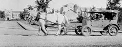
The Homestead Act permitted settlers to acquire one quarter of a square mile of land to homestead and offered an additional quarter upon establishing a homestead. Immigration peaked in 1910, and in spite of the initial difficulties of frontier life, distance from towns, sod homes, and backbreaking labour, a prosperous agrarian society was established.
In 1913, the Saskatchewan Stock Growers Association was established as Saskatchewan's first ranchers' organization. Three objectives were laid out at the founding convention in 1913 have served as a guide: to watch over legislation; to forward the interests of the Stock Growers in every honourable and legitimate way; and to suggest to parliament legislation to meet changing conditions and requirements. Its farming equivalent, the Saskatchewan Grain Growers Association, was the dominant political force in the province until the 1920s and had close ties with the governing Liberal party.
In the late 1920s, the Ku Klux Klan imported from the United States and Ontario and gained brief popularity in WASP nativist circles in Saskatchewan and Alberta. The Klan, briefly allied with the provincial Conservative party because of their mutual dislike for Premier James G. "Jimmy" Gardiner and his Liberals (who ferociously fought the Klan), enjoyed about two years of prominence, then disappeared, victims of widespread political and media opposition plus scandals involving their own funds.
In 1970, the first annual Canadian Western Agribition was held in Regina. This farm-industry trade show, with its heavy emphasis on livestock, is rated as one of the five top livestock shows in North America, along with those in Houston, Denver, Louisville and Toronto.
Demographics
According to the 2006 Canadian census,[12] the largest ethnic group in Saskatchewan is German (30.0%), followed by English (26.5%), Scottish (19.2%), Irish (15.3%), Ukrainian (13.6%), French (12.4%), First Nations (12.1%), Norwegian (7.2%), Polish (6.0%), Métis (4.4%), Dutch (3.7%), Russian (3.7%) and Swedish (3.5%) - although 18.1% of all respondents also identified their ethnicity as "Canadian".
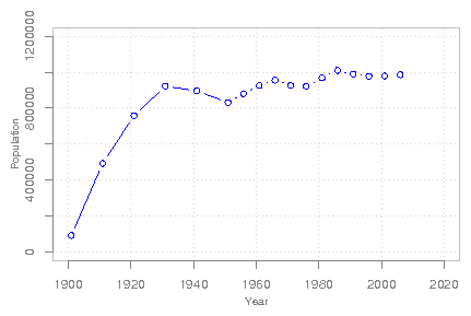
| Year | Population | Five-year % change |
Ten-year % change |
Rank among provinces |
|---|---|---|---|---|
| 1901 | 91,279 | n/a | n/a | 8 |
| 1911 | 492,432 | n/a | 439.5 | 3 |
| 1921 | 757,510 | n/a | 53.8 | 3 |
| 1931 | 921,785 | n/a | 21.7 | 3 |
| 1941 | 895,992 | n/a | -2.8 | 3 |
| 1951 | 831,728 | n/a | -7.2 | 5 |
| 1956 | 880,665 | 5.9 | n/a | 5 |
| 1961 | 925,181 | 5.1 | 11.2 | 5 |
| 1966 | 955,344 | 3.3 | 8.5 | 6 |
| 1971 | 926,242 | -3.0 | 0.1 | 6 |
| 1976 | 921,325 | -0.5 | 3.6 | 6 |
| 1981 | 968,313 | 5.1 | 4.5 | 6 |
| 1986 | 1,009,613 | 4.3 | 9.6 | 6 |
| 1991 | 988,928 | -2.0 | 2.1 | 6 |
| 1996 | 976,615 | -1.2 | -3.3 | 6 |
| 2001 | 978,933 | 0.2 | -1.0 | 6 |
| 2006 | 985,386 | 0.7 | 0.9 | 6 |
The largest denominations by number of adherents according to the 2001 census were the Roman Catholic Church with 286,815 (30%); the United Church of Canada with 187,450 (20%); and the Lutherans with 78,520 (8%). 148,535 (15.4%) responded "no religion".[15]
Municipalities
Ten largest municipalities by population
| Municipality | 1996 | 2001 | 2006 |
|---|---|---|---|
| Saskatoon | 193,653 | 196,861 | 202,340 |
| Regina | 180,404 | 178,225 | 179,246 |
| Prince Albert | 34,777 | 34,291 | 34,138 |
| Moose Jaw | 32,973 | 32,131 | 32,132 |
| Yorkton | 15,154 | 15,107 | 15,038 |
| Swift Current | 14,890 | 14,821 | 14,946 |
| North Battleford | 14,051 | 13,692 | 13,190 |
| Estevan | 10,752 | 10,242 | 10,084 |
| Weyburn | 9,723 | 9,534 | 9,433 |
| Corman Park | 7,142 | 8,043 | 8,349 |
This list does not include Lloydminster, which has a total population of 24,028 but straddles the Alberta-Saskatchewan border. As of 2006, only 8,118 people lived on the Saskatchewan side, which would make it Saskatchewan's 11th largest municipality. All of the listed communities are considered cities by the province, with the exception of Corman Park, which is a rural municipality. Municipalities in the province with a population of 5,000 or more can receive official city status.
Economy
Saskatchewan's economy is associated with agriculture; however, increasing diversification has meant that now agriculture, forestry, fishing, and hunting together make up only 6.8% of the province's GDP. Saskatchewan grows 45% of Canada's grain. Wheat is the most familiar crop and the one most often associated with the province (there are sheafs of wheat depicted on the coat of arms of Saskatchewan), but other grains like canola, flax, rye, oats, peas, lentils, canary seed, and barley are also produced. Beef cattle production in the province is only exceeded by Alberta. Mining is also a major industry in the province, with Saskatchewan being the world's largest exporter of potash and uranium.[16] In the northern part of the province, forestry is also a significant industry.
Oil and natural gas production is also a very important part of Saskatchewan's economy, although the oil industry is larger. Only Alberta exceeds the province in overall oil production.[17] Heavy crude is extracted in the Lloydminster-Kerrobert-Kindersley areas. Light crude is found in the Kindersley-Swift Current areas as well as the Weyburn-Estevan fields. Natural gas is found almost entirely in the western part of Saskatchewan, from the Primrose Lake area through Lloydminster, Unity, Kindersley, Leader, and around Maple Creek areas.[18]
Saskatchewan's GDP in 2006 was approximately C$45.922 billion,[19] with economic sectors breaking down in the following way:
| % | Sector |
|---|---|
| 17.1 | finance, insurance, real estate, leasing |
| 13.0 | mining, petroleum |
| 11.9 | education, health, social services |
| 11.7 | wholesale and retail trade |
| 9.1 | transportation, communications, utilities |
| 7.7 | manufacturing |
| 6.8 | agriculture, forestry, fishing, hunting |
| 6.5 | business services |
| 5.8 | government services |
| 5.1 | construction |
| 5.3 | other |
A list of the top 100 companies includes The Potash Corporation of Saskatchewan, Federated Cooperatives Ltd. and IPSCO.
Major Saskatchewan-based Crown corporations are Saskatchewan Government Insurance (SGI), SaskTel, SaskEnergy (the province's main supplier of natural gas), and SaskPower. Bombardier runs the NATO Flying Training Centre at 15 Wing, near Moose Jaw. Bombardier was awarded a long-term contract in the late 1990s for $2.8 billion from the federal government for the purchase of military aircraft and the running of the training facility. SaskPower since 1929 has been the principal supplier of electricity in Saskatchewan, serving more than 451,000 customers and managing $4.5 billion in assets. SaskPower is a major employer in the province with almost 2,500 permanent full-time staff located in 71 communities.
Provincial finances
| Fiscal Year | Population1 | Public Debt2 | Budget Surplus | GFSF Balance | Pers. Inc. Tax Revenue | Corp. Inc. Tax | Sales tax Revenue | Resource Revenue | Health Expense |
|---|---|---|---|---|---|---|---|---|---|
| 2010-2011 | 1,041,729 | - | - | - | - | - | - | - | - |
| 2009-2010 | 1,025,638 | 4,140,482 | 167,705 | 958,000 | 1,890,848 | 881,424 | 1,084,001 | 1,910,624 | 3,934,231 |
| 2008-2009 | 1,010,218 | 4,145,286 | 1,969,933 | 1,215,000 | 1,844,226 | 591,930 | 1,108,628 | 4,612,408 | 3,976,241 |
| 2007-2008 | 996,130 | 6,824,323 | 1,282,869 | 1,528,934 | 1,938,258 | 673,641 | 995,995 | 2,325,116 | 3,504,333 |
| 2006-2007 | 991,260 | 7,244,938 | 397,794 | 887,500 | 1,668,538 | 554,001 | 1,079,794 | 1,694,252 | 3,202,965 |
| 2005-2006 | 994,996 | 7,197,223 | 539,466 | 887,500 | 1,447,905 | 393,629 | 1,112,350 | 1,721,100 | 2,990,625 |
| 2004-2005 | 997,263 | 7,545,574 | 765,117 | 748,500 | 1,329,081 | 257,679 | 985,079 | 1,474,191 | 2,773,961 |
| 2003-2004 | 995,848 | 8,031,637 | -210,017 | 366,000 | 1,245,763 | 310,573 | 854,480 | 1,140,962 | 2,515,823 |
| 2002-2003 | 997,805 | 7,821,426 | 82,860 | 577,000 | 1,429,757 | 178,267 | 813,932 | 1,243,649 | 2,342,835 |
| 2001-2002 | 1,001,643 | 7,561,899 | -278,902 | 495,000 | 1,196,410 | 145,338 | 770,984 | 903,044 | 2,199,723 |
The Tabulated Data covers each fiscal year (e.g. 2009-2010 covers April 1, 2009 - March 31, 2010). All data is in $1,000s.
1 These values reflect the estimated population at the beginning of the fiscal year.
2 These values reflect the debt of the General Revenue Fund alone. It does not reflect the debt of Government Service Organizations (Health Authorities, Crop Insurance Corporation, etc.) or Government Service Enterprises (Crown Corporations).
Source: Government of Saskatchewan.[20]
Government and politics
Saskatchewan has the same form of government[21] as the other Canadian provinces with a lieutenant-governor (who is the representative of the Crown in Right of Saskatchewan), premier, and a unicameral legislature.
For many years, Saskatchewan has been one of Canada's more progressive provinces, reflecting many of its citizens' feelings of alienation from the interests of large capital. In 1944 Tommy Douglas became premier of the first avowedly socialist regional government in North America. Most of his Members of the Legislative Assembly (MLAs) represented rural and small-town ridings. Under his Cooperative Commonwealth Federation government, Saskatchewan became the first province to have Medicare. In 1961, Douglas left provincial politics to become the first leader of the federal New Democratic Party.
Provincial politics in Saskatchewan is dominated by the New Democrats and the Saskatchewan Party. Numerous smaller political parties also run candidates in provincial elections, including the Green Party, Liberal Party, and the Progressive Conservative Party, but none is currently represented in the Legislative Assembly of Saskatchewan. After 16 years of New Democratic governments under premiers Roy Romanow and Lorne Calvert, the recent 2007 provincial election was won by the Saskatchewan Party under Brad Wall.
Recent federal elections have been dominated by the Conservative Party since the party currently represents 13 of 14 federal ridings in Saskatchewan, while the Liberal Party of Canada represents one federal riding.
While both Saskatoon and Regina (Saskatchewan's largest cities) are roughly twice the population of an urban riding in Canada, both are split into multiple ridings that blend them with rural communities.
Law and order
- Police agencies
- Estevan Police Service
- File Hills First Nation Police Service
- Luseland Police Service
- Moose Jaw Police Service
- Prince Albert Police Service
- Regina Police Service
- RM of Corman Park Police Service
- Royal Canadian Mounted Police
- Saskatoon Police Service
- Weyburn Police Service
- Correctional facilities
- Pine Grove Correctional Centre
- Prince Albert Correctional Centre
- Regina Correctional Centre
- Regina Paul Dojack Youth Centre
- Saskatchewan Penitentiary
- Saskatoon correctional centre
- Saskatoon Kilburn Hall
Education
The first education on the prairies was learned within the family group of the first nation or early fur trading family settlers. There were only a few missionary or trading post schools established in Rupert's Land – later known as the North West Territories.
The first 76 North-West Territories school districts and the first Board of Education meeting formed in 1886. The pioneering boom formed ethnic bloc settlements. Communities were seeking education for their children similar to the schools of their home land. Log cabins, and dwellings were constructed for the assembly of the community, school, church, dances and meetings.
The roaring twenties and established farmers who had successfully proved up on their homesteads helped provide funding to standardize education. Text books, normal schools for formally educated teachers, school curricula, state of the art school house architectural plans, provided continuity throughout the province. English as the school language helped to provide economic stability because one community could communicate with another and goods could be traded and sold in a common language. The number of one-room school house districts across Saskatchewan totalled approximately 5,000 at the height of the one-room school house educational system in the late 1940s.
Following World War II, the transition from many one room school houses to fewer and larger consolidated modern technological town and city schools occurred as a means of ensuring technical education. School buses, highways, and family vehicles create ease and accessibility of a population shift to larger towns and cities. Combines and tractors mean that the farmer could successfully manage more than a quarter section of land, so there was a shift from family farms and subsistence crops to cash crops grown on many sections of land.
School vouchers have been newly proposed as a means of allowing competition between rural schools and making the operation of co-operative schools practicable in rural areas.
Healthcare
Saskatchewan's medical health system is widely and inaccurately characterised as "socialized medicine": medical practitioners in Saskatchewan, as in other Canadian provinces, are not civil servants but remit their accounts to the publicly funded Saskatchewan Medical Care Insurance Plan rather than to patients.[22] Unlike in Medicare in Australia and private medicine in the UK, Saskatchewan sets a statutory tariff for medical services which may not be exceeded.
Arts and culture
- Museums and galleries
- Duck Lake Regional Interpretive Centre
- MacKenzie Art Gallery
- Mendel Art Gallery
- Morse Museum and Cultural Centre
- Museums Association of Saskatchewan
- Shurniak Art Gallery
- RCMP Heritage Centre
- Royal Saskatchewan Museum
- Saskatchewan Western Development Museum
- Ukrainian Museum of Canada
- Outlook & District Heritage Museum - now on Facebook
- Artist-run centres
- AKA Gallery
- PAVED Arts
- Neutral Ground Artist-Run Centre and Soil Digital Media Suite, Regina
- The Gallery on Sherbrooke, Wolseley
- Artists
- Dr William Hobbs, prairie and railways painter.
- Joe Fafard, sculptor
- Rod and Denyse Simair, crystalline porceline artists, winners of multiple worldwide awards
- Rob Bos, paintings of multi-coloured trees.
- Wilf Perreault paintings of back alleys.
- Robin Poitras, dancer, organizer.
- William Argan, cartoon artist.
Canadian television sitcoms Corner Gas and Little Mosque on the Prairie are both set in small Saskatchewan towns. The novels of W. O. Mitchell, Sinclair Ross, Frederick Philip Grove, Guy Vanderhaeghe, Michael Helm and Gail Bowen are also frequently set in Saskatchewan, as are children's novels of Farley Mowatt. The English naturalist "Grey Owl" spent much of his life living and studying in what is now Prince Albert National Park.
The Arrogant Worms' song "The Last Saskatchewan Pirate" about a disgruntled farmer who takes up piracy on the namesake river mentions various parts of the province such as Saskatoon, Regina and Moose Jaw. Popular Québécois band Les Trois Accords recorded a song in French called "Saskatchewan" on its first album, Gros Mammouth Album. It was the third single of that album and met moderate success in French Canada.
The Saskatchewan Roughriders are the province's only major professional sports franchise, and are extremely popular across Saskatchewan. The team's fans are also found to congregate on game days throughout Canada, and collectively they are known as "Rider Nation".
In 2006, the founder of One Red Paperclip, Kyle MacDonald, ended his trading-game after swapping a movie role in the film Donna on Demand for a two-story farmhouse in Kipling, Saskatchewan.
Provincial symbols
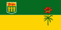
The flag of Saskatchewan was officially adopted on 22 September 1969. The flag features the provincial shield in the upper quarter nearest the staff, with the floral emblem, the Prairie Lily, in the fly. The upper green (in forest green) half of the flag represents the northern Saskatchewan forest lands, while the golden lower half of the flag symbolizes the southern wheat fields and prairies. A province-wide competition was held to design the flag, and drew over 4,000 entries. The winning design was by Anthony Drake, then living in Hodgeville.[23]
In 2005, Saskatchewan Environment held a province-wide vote to recognize Saskatchewan's centennial year, receiving more than 10,000 on-line and mail-in votes from the public. The walleye was the overwhelming favourite of the six native fish species nominated for the designation, receiving more than half the votes cast.[24] Other species in the running were the lake sturgeon, lake trout, lake whitefish, northern pike and yellow perch.
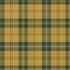
Saskatchewan's other symbols include the tartan, the license plate, and the provincial flower. Saskatchewan's official tartan was registered with the Court of Lord Lyon King of Arms in Scotland in 1961. It has seven colours: gold, brown, green, red, yellow, white and black. The provincial licence plates display the slogan "Land of Living Skies". The provincial flower of Saskatchewan is the Western Red Lily.
Centennial celebrations

In 2005, Saskatchewan celebrated its centennial. To honour it, the Royal Canadian Mint issued a commemorative five-dollar coin depicting Canada's wheat fields as well as a circulation 25-cent coin of a similar design. Queen Elizabeth II and the Duke of Edinburgh visited Regina, Saskatoon and Lumsden, and the Saskatchewan-reared Joni Mitchell issued an album in Saskatchewan's honour.
See also
- 45561 Saskatchewan British Jubilee Class locomotive named after the province.
- District of Assiniboia
- Legislative Assembly of Saskatchewan
- Saskatchewan Film and Video Classification Board
- Scouting in Saskatchewan
- The Saskatchewan Act
- Tourism in Saskatchewan
Lists:
- List of airports in Saskatchewan
- List of Canadian provincial and territorial symbols
- List of cities in Canada
- List of communities in Saskatchewan
- List of Leaders of the Opposition in Saskatchewan
- List of premiers of Saskatchewan
- List of rural municipalities in Saskatchewan
- List of Saskatchewan general elections
- List of Saskatchewan lieutenant-governors
- List of Saskatchewan rivers
- List of Saskatchewan-related topics
- List of towns in Saskatchewan
Notes
- ↑ Saskatchewanian is the prevalent demonym, and is used by the Government of Saskatchewan. According to the Oxford Guide to Canadian English Usage (ISBN 0-19-541619-8; p. 335), Saskatchewaner is also in use.
- ↑ "Canada's population estimates: Table 2 Quarterly demographic estimates". Statcan.gc.ca. 2010-06-28. http://www.statcan.gc.ca/daily-quotidien/100628/t100628a2-eng.htm. Retrieved 2010-06-30.
- ↑ Statistics Canada Gross domestic product, expenditure-based, by province and territory
- ↑ Statistics Canada, Quarterly demographic estimates, 2009
- ↑ Government of Canada
- ↑ Hydrology from The Encyclopedia of Saskatchewan
- ↑ Bray, Tim (2008-12-23). "2008/12/23, Four PM". http://www.tbray.org/ongoing/When/200x/2009/02/06/2008-12-23. Retrieved 2008-02-28. "English just doesn’t have words to describe cold of that intensity. I was appropriately dressed but am still a mild-climate West Coast Wimp, and the cold hurt me wherever it touched me; and it tried really hard to find chinks in my clothing's armor to penetrate and hurt."
- ↑ Average Weather for Saskatoon, SK - Temperature and Precipitation
- ↑ "National Climate Data and Information Archive". Environment Canada. http://climate.weatheroffice.gc.ca/Welcome_e.html. Retrieved 2010-09-02.
- ↑ The first smallpox epidemic on the Canadian Plains: In the fur-traders' words. The Canadian Journal of Infectious Diseases.
- ↑ Batoche by Dave Yanko
- ↑ Ethnic origins, 2006 counts, for Canada, provinces and territories - 20% sample data
- ↑ The history of Saskatchewan's population from Statistics Canada
- ↑ Canada's population. Statistics Canada. Retrieved September 28, 2006.
- ↑ Religions in Canada
- ↑ Fact Sheet from the Saskatchewan Mining Association
- ↑ Government of Saskatchewan. Oil and Gas Industry. Retrieved on: April 26, 2008.
- ↑ Government of Saskatchewan. The Saskatchewan Oil and Gas InfoMap. Retrieved April 26, 2008.
- ↑ Gross domestic product, expenditure-based, by province and territory from Statistics Canada
- ↑ Public Accounts of Saskatchewan. Government of Saskatchewan. Retrieved July 5, 2010.
- ↑ Government of Saskatchewan. "official page". http://www.gov.sk.ca. Retrieved 2007-02-15.
- ↑ How Saskatchewan Health Pays Your Bill - Health - Government of Saskatchewan
- ↑ "Saskatchewan, flag of". Encyclopædia Britannica. 2008. http://www.britannica.com/EBchecked/topic/1355491/Saskatchewan-flag-of. Retrieved 2008-07-09.
- ↑ Walleye Wins Vote For Saskatchewan's Fish Emblem
References
- Archer, John H. Saskatchewan: A History. Saskatoon: Western Producer Prairie Books, 1980. 422 pp.
- Bennett, John W. and Kohl, Seena B. Settling the Canadian-American West, 1890-1915: Pioneer Adaptation and Community Building. An Anthropological History. University of Nebraska Press, 1995. 311 pp.
- Bill Waiser. Saskatchewan: A New History (2006)
- Bocking, D. H., ed. Pages from the Past: Essays on Saskatchewan History. Saskatoon: Western Producer Prairie Books, 1979. 299 pp.
- LaPointe, Richard and Tessier, Lucille. The Francophones of Saskatchewan: A History. Regina: University of Regina, Campion Coll., 1988. 329 pp.
- Lipset, Seymour M. Agrarian Socialism: The Cooperative Commonwealth Federation in Saskatchewan: A Study in Political Sociology, University of California Press, 1950.
- Martin, Robin Shades of Right: Nativist and Fascist Politics in Canada, 1920-1940, University of Toronto Press, 1992.
- Smith, David E., ed. Building a Province: A History of Saskatchewan in Documents. Saskatoon: Fifth House, 1993. 443 pp.
- Smith, Dennis. Rogue Tory: The Life and Legend of John G. Diefenbaker. Toronto: Macfarlane Walter & Ross, 1995. 702 pp.
External links
- Government of Saskatchewan
- Saskatchewan at the Open Directory Project
- CBC Digital Archives - Saskatchewan @ 100
- Royal Canadian Mounted Police
- Saskatchewan!
- SaskTourism
|
|||||||||||||||||
|
||||||||||||||||||||||||||
|
||||||||||||||
|
|||||||||||||||||||||||||||||||||||||||||||||||||||||||