Watford
| Watford | |||
|---|---|---|---|
| — Town and Borough — | |||
| Borough of Watford | |||
|
|
|||
|
|||
| Motto: Audentior[1] | |||
 |
|||
| Coordinates: | |||
| Country | United Kingdom | ||
| Constituent country | England | ||
| Region | East of England | ||
| County | Hertfordshire | ||
| Borough | Watford | ||
| UK Parliament constituency | Watford | ||
| Government | |||
| - Type | Borough with Mayor & Cabinet | ||
| - Mayor | Dorothy Thornhill (Liberal Democrat) | ||
| - MP | Richard Harrington (Conservative) | ||
| Area | |||
| - Borough | 21.5 km2 (8.3 sq mi) | ||
| Elevation | 71 m (233 ft) | ||
| Population | |||
| - Borough | 80,000 | ||
| - Density | 3,721.5/km2 (9,638.6/sq mi) | ||
| - Urban | 121,000 | ||
| - Ethnicity[2] | 83.0% White 9.2% South Asian 3.5% Black 2.5% Mixed Race 1.6% Chinese or other |
||
| Time zone | GMT | ||
| - Summer (DST) | Summer Time (British) (UTC+1) | ||
| Postcode area | WD | ||
| Area code(s) | 01923 | ||
| ONS code | 26UK | ||
| Website | www.watford.gov.uk | ||

Watford (pronounced /ˈwɒtfɚd/ (![]() listen)) is a town and borough in Hertfordshire, England, situated 20 miles (32 km) northwest of central London and within the bounds of the M25 motorway. The borough is separated from Greater London to the south by the urbanised parish of Watford Rural in the Three Rivers District.
listen)) is a town and borough in Hertfordshire, England, situated 20 miles (32 km) northwest of central London and within the bounds of the M25 motorway. The borough is separated from Greater London to the south by the urbanised parish of Watford Rural in the Three Rivers District.
Watford was created as an urban district under the Local Government Act 1894, and became a municipal borough by grant of a charter in 1922. The borough had 79,726 inhabitants at the time of the 2001 Census.[3] The most recent official estimates put the population of Watford at 79,600 at mid-2006.[4]
The nearby areas of Bushey, Rickmansworth, Chorleywood, Kings Langley, Abbots Langley, Carpenders Park and South Oxhey, located in Three Rivers and Hertsmere districts, also form part of the Watford postcode area. The Watford urban area, which includes much of the neighbouring districts, had a total population of 120,960 in the 2001 census,[5] making it the 47th largest urban area in England.
Contents |
History
Origins
Watford stands on a low hill near the point at which the River Colne was forded by travellers between London and the Midlands. This route, originally a pre-Roman trackway, departed from the ancient Roman Watling Street at Stanmore, heading for the Gade valley and thence up the Bulbourne valley to a low and easily traversed section of the Chiltern Hills near Tring. The modern High Street follows the route of this road.[6][7]
The ford was close to the later site of a gas works site. The town probably originated in Saxon times as a string of houses on the northern side of this ford. It was located on the first dry ground above the marshy edges of the River Colne. It is generally agreed that the town is named after the ford, but the origin of the first part of the name is uncertain. Theories include the Old English words wæt (wet), wadan (wade), watul (wattle, a fence) or wath (hunter), Watling Street, and a hypothetical Saxon landowner called "Wata".[7]
Early history
Watford is first mentioned in an Anglo-Saxon charter of 1007. It does not get a mention by name in the Domesday Book, but was included in the entry for the then more important settlement of Cashio which stood half a mile away at the crossroads of the St Albans road and Hempstead road near the modern Town Hall.[8]
The settlement's location helped it to grow, since as well as trade along this north-south through route it possessed good communications into the vale of St Albans to the east and into the Chiltern Hills along the valley of the River Chess to the west. In 1100 Henry I granted a charter to Watford to hold a weekly market.[6]
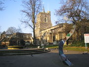
The parish church of St Mary the Virgin was built in 1230 on the same site as an earlier Saxon church. It was extensively restored in 1871.[9]
The great houses of Cassiobury and The Grove were built in the seventeenth centuries and expanded and developed throughout the following centuries. Cassiobury became the family seat of the Earls of Essex, and The Grove the seat of the Earls of Clarendon.[8]
The Sparrows Herne turnpike was established in 1762 to improve the route across the Chilterns, with the road maintained from charges levied at toll houses along the way. The location of a toll house can be seen at the bottom of Chalk Hill on the Watford side of Bushey Arches close to the Wickes hardware store; set in an old flint stone wall is a Sparrows Herne Trust plaque.[10]
Industrial Revolution
Watford remained an agricultural community with some cottage industry for many centuries. The Industrial Revolution brought the Grand Junction Canal (now Grand Union Canal) in 1798 and the London and Birmingham Railway in 1837, both located here for the same reasons the road had followed centuries before, seeking an easy gradient over the Chiltern Hills. The land-owning interests permitted the canal to follow closely by the river Gade, but the prospect of smoke-emitting steam trains drove them to ensure the railway gave a wide berth to the Cassiobury and Grove estates. Consequently, although the road and canal follow the easier valley route, the railway company was forced to build an expensive tunnel under Leavesden to the north of the town. The main Watford railway station was and remains outside of the town centre to the east at Watford Junction.[11]
These developments gave the town excellent communications and stimulated its industrial growth during the nineteenth and twentieth centuries. The Grand Union Canal, allowed coal to be brought into the district and paved the way for industrial development. The Watford Gas and Coke Company was formed in 1834 and gas works built. The canal allowed paper-making mills to be sited at Croxley. The John Dickinson and Co. Mill beside the canal here manufactured the Croxley brand of fine quality paper. The paper making influenced the development of printing in the town which continues today. There had been brewing in Watford from the seventeenth century and, by the nineteenth century, two industrial scale brewers Benskin’s and Sedgwick’s were located in the town.[12]
Economy
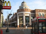
Watford is a major regional centre for the northern home counties. It is the most westerly of these commercial centres and the only one in Hertfordshire. Hertfordshire County Council designates Watford and Stevenage to be its major sub-regional centres, heading its list of preferred sites for retail development.[13] The primary shopping area is the Harlequin Shopping Centre, a large purpose-built indoor mall with over 140 shops, restaurants and cafes built during the 1990s, opened officially in June 1992.
The High Street, running through the town centre, is the main focus of activity at night having a high concentration of the town's bars, clubs and restaurants.
The head offices of a number of national companies such as British Waterways, J D Wetherspoon, Camelot Group, operator of the National Lottery; Iveco, manufacturers of commercial vehicles; Haden Young, the building services division of Balfour Beatty; Bathstore, the largest bathroom retailer in the UK; construction firm Taylor Woodrow; and Mothercare, are located in the town. The borough is also the UK base of many multi-nationals including Total Oil, Sanyo, TK Maxx, Costco, Vinci, and Beko. International golf tournaments such as the 2006 World Golf Championship have taken place at the Grove hotel.
The town was home to the Scammell Lorries Factory from 1922 until its closure in 1988. The site is now a residential area. Tandon motorcycles, founded by Devdutt Tandon, were also manufactured in Colne Way, By-Pass road, Watford from 1947 until 1959. Models included the Imp, the Milemaster, the Superglide and the Kangaroo.
Plans are underway to develop a new Health Campus complete with heliport adjacent to the site of the current Watford General Hospital.
Transport
Road
Watford is close to strategic roads - the M25 motorway that rings London and the M1 motorway that connects London to the Midlands and northern England.
Rail
The town is served by one of the principal National Rail north-south rail routes – the West Coast Main Line – which connects London (terminus at London Euston) to the Midlands, north-west England and Scotland. Some long-distance trains on this route serve Watford Junction, where there are also frequent suburban and regional trains. There is a shuttle train service to St Albans, via some local stations in North Watford, and a direct rail connection to East Croydon Railway Station via Clapham Junction. London Overground services run from Watford Junction along a suburban loop to Watford High Street station and Bushey station, continuing along the Watford DC Line to London Euston.
London Underground serves Watford Metropolitan Line station at the outer north-western boundary of the Tube system. The station is located outside the centre of Watford, close to Cassiobury Park. If the proposed Croxley Rail Link goes ahead, the Metropolitan Line branch would be diverted to Watford Junction via the disused Croxley Green branch, providing two new Underground stations between Croxley and Watford Junction.[14]
It has been suggested that Regional Eurostar services could run from Watford to Paris via Kensington Olympia.[15][16] The Select Committee on Environment, Transport and the Regions recommended:
"We believe that Watford is well placed to become an integrated transport hub, and we recommend that the Government's review should consider what benefits and costs would be associated with direct services from Watford, and thorough services on the West Coast Main Line calling at Watford. Subject to the review's findings, we recommend that services from Watford to Paris should commence as soon as possible. The proposal for a Watford hub, as outlined in broad terms in ICRR's report is of interest to the Government. If there is a possibility that services to link the regions to the Channel Tunnel could be provided by such a link, the Government would be keen to see such a service operate."[17]
Water
Watford is on the main Grand Union Canal route northwards from London. There is little commercial use, since the advent of the railway, but the canal is used for recreational purposes.
The River Gade and the River Colne also run through Watford.
Air
Regular and frequent bus and coach services connect Watford Junction station to Heathrow Airport and Luton Airport, direct train services run from Watford Junction Station to Birmingham International Airport and also used to run to Gatwick (as of 2009 is mandatory to change train at Clapham Junction or London Euston and London Victoria Station).
Watford's closest airfield is Elstree Aerodrome, 3 miles (5 km) east of the town. Many private charters, as well as occasional holiday charters take off from here, with the on-request customs service contributing to the popularity of this airfield.
The Rolls Royce or de Havilland factory as it was known in World War II at Leavesden was responsible for the manufacture of the Mosquito fighter bomber and the Halifax bomber during the second world war and later became Leavesden Aerodrome, to the north of Watford, which is no longer operational. It was converted into Leavesden Film Studios, now famously the home of the Harry Potter films.
Education
History
William Saunders noted in 1595 a "George Redhead, schoolmaster" of Watford, and in 1640 Francis Combe gave £10 a year to a Free School in Watford for teaching the poor to cast accounts, to read English and to write.[6] It was recorded then that, "The master hath the use of a room over two houses belonging to the Church Estate, nearest the churchyard." In 1704, Mrs Elizabeth Fuller of Watford Place built a new Free School for forty boys and twenty girls on her land next to the churchyard, with rooms for a Master and a Mistress.[11]
In the mid-19th century, the only schools in Watford were Mrs Fuller's Free School, by now in a poor state, and St Mary's National Schools (separate schools for boys and girls) in Church Street. All offered elementary education. State-funded elementary schools began to appear in the 1860s and 1870s. The Free School closed in 1882, and its endowment contributed to founding the Watford Endowed Schools, which provided secondary education and charged fees.[18] After these schools, now called the Watford Grammar School for Boys and the Watford Grammar School for Girls, moved to new sites in 1907 and 1912, the building housed the Watford Central School, which taught pupils up to the age of 14. St Mary's National Schools closed in 1922, and the site is now a car park.[19][20]
The London Orphan Asylum, later Reed's School, was located near Watford Junction station between 1871 and 1940. The buildings are now the Reeds housing estate off Orphanage Road.
Primary schools
All the state-funded primary schools in Watford are co-educational. Under an earlier system, schools were divided into infant schools, covering Reception and Years 1 and 2, and junior schools, covering Years 3 to 6. Most such schools have amalgamated to form Junior Mixed Infant schools or (equivalently) primary schools, and all new schools are of this type. Within the municipal borough, there are now 6 linked pairs of infant schools and junior schools, and 14 JMI or primary schools, of which 2 are Roman Catholic. The Watford urban area is also served by schools in the neighbouring districts of Three Rivers and Hertsmere.
Secondary schools
Although all state-funded secondary schools in Hertfordshire are comprehensive, there is a great deal of differentiation in the southwestern corner of the county, centred on Watford but also including most of the Three Rivers district and Bushey in Hertsmere district. Within this area, there are:[21]
- partially selective schools, which offer a proportion of places according to ability or aptitude, and the rest to siblings or those living near the school: Parmiter's School, Queens' School, Rickmansworth School, St Clement Danes School, Watford Grammar School for Boys and Watford Grammar School for Girls.
- Bushey Meads School, which selects 10% for technological aptitude and uses banded admissions to ensure a comprehensive intake for the remainder.
- non-selective Roman Catholic schools, whose intake is evenly spread: St Joan of Arc Catholic School and St Michael's Catholic High School.[22]
- other non-selective schools, whose intake is markedly affected by the above partially selective schools: The Bushey Academy, Francis Combe Academy and Westfield Community Technology College.[23]
The partially selective schools and Bushey Meads School operate common admissions tests in mathematics and non-verbal reasoning each autumn. In addition to those seeking selective places, all applicants to Bushey Meads and Queens' Schools are required to take the tests, so they are taken by the majority of Year 6 children in the area. The partially selective schools also operate a common test and audition procedure to select children for specialist music places.[21]
Results achieved by the schools at GCSE are also widely spread, including the three highest and the two lowest scoring state schools within Hertfordshire.[24][25] The area also has by far the highest incidence in the county of children allocated to schools to which they had not applied.[26]
Sport
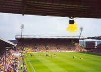
Watford is home to professional football team Watford F.C., who reached the FA Cup Final in 1984 (as well as four other semi-finals), also finishing as league runners-up in 1983. They were relegated from the old Division One in 1988. In 1996, Watford were relegated from the new Division One (now Football League Championship).
Watford won the then Nationwide Division Two championship in 1998, then the following season (1998–99) reached the Premiership by winning the First Division Play-Off Final, beating Bolton Wanderers F.C. at Wembley Stadium by two goals to nil. The club were relegated the season after.
After five years of uncertainty, Watford won the Football League Championship Play-Off Final against all the odds to achieve promotion to the Premiership once again in 2006, this time beating Leeds United A.F.C. by three goals to nil. Again, as before they were relegated to the Football League Championship after a single season (2006–2007) in the Premiership.
Singer-songwriter Sir Elton John is a keen, long-term supporter of Watford F.C. and a former club chairman. He still maintains his links with Watford as Honorary Life President.[27]
Since 1997 the club has shared its ground, Vicarage Road, with Saracens Rugby Football Club.
Places of interest
Cassiobury Park
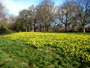
Cassiobury Park was formed from the grounds of Cassiobury House and consists of 190 acres (0.77 km2) of open space. The house itself was demolished in 1927 and the original imposing gatehouse entrance - the Cassiobury Gates - in the 1970s, due to road widening. In July 2007, the park won a Green Flag Award, which recognises the best green spaces in the country.[28] It has a children's play area which includes a paddling pool, play equipment, mini train track for children's rides, bouncy castle, ice cream van and a kiosk where you can buy food and drinks. The Grand Union Canal passes through the park.
The name derives from a Celtic tribe the Cassii said to have inhabited the area in pre-Roman times.
Watford Colosseum
The Watford Colosseum was used to record the Lord of the Rings, the Sound of Music, The Star Wars Trilogies, Sleepy Hollow soundtracks and is world renowned for its acoustic qualities, which are often said to be the best available in the UK. Among many famous classical recordings made there is Julian Lloyd Webber's performance of Elgar's Cello Concerto, conducted by Yehudi Menuhin.
It has housed performances from world renowned performers as The Who, Robbie Williams, Oasis and was well known for its Seventies Disco's featuring Jensen D Groover & Carlos Fandango up until 2003. It is now in administration after funding difficulties, but is still open to bookings whilst the local council decides its fate.[29]
It is regularly used to host concerts by the BBC Concert Orchestra, in particular the long running Friday Night is Music Night. Laura, Austin and Amy from the X-Factor have also performed there.
Watford Palace Theatre
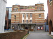
The Watford Palace Theatre is the only producing theatre in Hertfordshire. It presents a selection of comedy, drama, world premieres, family friendly shows and an annual traditional pantomime. Situated just off the High Street, the Edwardian theatre building is approaching its centenary and has recently been refurbished.
The Pumphouse Theatre and Arts Centre
The Pump House Theatre and Arts Centre is based in an old pumping station situated in Watford's lower high street. The building was converted for use as a theatre, with rehearsal rooms, and meeting place for local arts based groups. Current facilities include a 124 seat theatre, rehearsal rooms, and live music venue. Community groups currently meeting at the Pump House include Dance House (children's ballet), Pump House Clog Morris (women's Morris dancing), Pump House Jazz (jazz club), Open House (live open mic music), Woodside Morris Men (men's Morris dancing), child, youth and adult theatre groups.[30]
"North of Watford" and "Watford Gap"
The phrase "North of Watford" is used in a light-hearted, yet derogatory sense—typically by those living in south eastern England—to describe any part of the United Kingdom situated more than a relatively short distance north of London and the Home Counties. It is a euphemism for 'provincial' and by extension 'unsophisticated'. It is commonly understood that the term is in fact highly arbitrary and flexible, applying to an approximate latitude rather than the town of Watford itself, but its use has contributed to a mildly negative association with the place name. However, in modern usage the term generally denotes the English Midlands and Northern England. See Bombay Hills for a similar cultural border concept in New Zealand.
The phrase is also linked to the Watford Gap, a motorway service station on the main north-south M1 motorway, which is located 50 miles north of the town.
Suburbs
Including areas outside Watford Borough:
|
|
|
|
Twin towns
Watford has five twin towns:[31]
 Mainz, Germany (since 1956)
 Nanterre, France (since 1960)
 Novgorod, Russia (since 1984)
 Wilmington, Delaware, United States (since 1985)
 Pesaro, Italy (since 1988)
Notable people
Watford was the birthplace of:
- Barbara Amiel, Lady Black of Crossharbour, journalist
- Stephen Andrew, Canadian television reporter, anchor and talk show host
- Grant Benson, Broadcaster
- Michael Bentine (1922–1996), comedian and ex-Goon
- LTJ Bukem, pioneering drum & bass DJ/Producer
- Sue Cleaver, actress, best known for her role as Eileen Grimshaw in Coronation Street.
- Michaela Breeze, female weightlifter
- Jack Collison, West Ham United and Wales footballer
- Ray Cooper, percussionist (performed in both Elton John's and Eric Clapton's bands)
- Anthony Berkeley Cox (1893–1971), crime fiction author
- Mark Walsh, professional darts player
- Chris Date, database guru, author of the definitive textbook on the subject[32]
- Paul Field 1994 Gladiators champion, police officer and two-time Winter Olympian from South Oxhey
- Cyril Fletcher (1913–2005), comedian
- Declan Ganley, Anglo/Irish businessman and political activist
- Philip Glenister, actor, Life on Mars
- Robert Glenister, actor
- Geri Halliwell, singer and Spice Girl
- Kenny Jackett, current Millwall manager
- Vinnie Jones, a British football player turned actor
- Matt King, comedy actor, Peep Show
- Nick Knight, cricketer
- Nick Leeson, rogue securities trader responsible for the collapse of Barings Bank in 1995
- Tim Lovejoy, television and radio presenter
- Gerald Moore (1899–1987), pianist
- Mo Mowlam (1949–2005), Labour politician
- J.D. Nicholas, singer with Heatwave and The Commodores
- Mark Oaten, Liberal Democrat politician
- Stuart Parkin, physicist
- Arthur Peacocke (1924–2006), biochemist and Anglican theologian
- James Pritchett, footballer for New Zealand
- Paul Robinson, Bolton Wanderers football player
- Terry Scott (1927–1994), TV and Carry On actor and comedian, blue plaque at 32 Tucker St [33][34]
- Grant Shapps, Conservative MP for nearby Welwyn Hatfield
- Kelly Smith, England and Arsenal footballer
- Simon Treves, actor and writer
- Ian Walker, former Tottenham Hotspur, Leicester City, Bolton Wanderers goalkeeper
- Bradley Walsh, Coronation Street actor and comedian
- Melanie Walsh, actress and model
- Arthur Woodward, footballer who spent his entire career at Watford
- Gallows, hardcore punk band formed in 2005
Watford is the burial place of:
- Thomas Webster Rammell, engineer Crystal Palace
See also
- Mayor of Watford
- Watford (UK Parliament constituency)
- Benskins
References
- ↑ Virgil. Aeneid. pp. VI, 95. "Tu ne cede malis, sed contra audentior ito. trans.: Yield thou not to adversity, but press on the more bravely."
- ↑ Area: Watford (Local Authority), Resident Population Estimates by Ethnic Group, All Persons, 2006, People and Society: Population and Migration, Office for National Statistics.
- ↑ 2001 Census, Key Statistics for Local Authorities, Office for National Statistics, 2003.
- ↑ Mid Year Population Estimates Hertfordshire 2006, Office for National Statistics, August 2007, revised October 2007.
- ↑ Census 2001, Key Statistics for urban areas, Office for National Statistics.
- ↑ 6.0 6.1 6.2 Samuel Lewis (ed.) (1848). "Watford (St. Mary)". A Topographical Dictionary of England (7th ed.). pp. 486. http://www.british-history.ac.uk/report.aspx?compid=51382#s1. Retrieved 2008-03-22.
- ↑ 7.0 7.1 W.R. Saunders (1931). History of Watford. Watford: Peacock.
- ↑ 8.0 8.1 William Page (ed.) (1908). "Watford: Manors". A History of the County of Hertford: volume 2. Victoria County History. pp. 451–464. http://www.british-history.ac.uk/report.asp?compid=43308. Retrieved 2008-05-19.
- ↑ William Page (ed.) (1908). "Watford: Churches and Charities". A History of the County of Hertford: volume 2. Victoria County History. pp. 464–469. http://www.british-history.ac.uk/report.asp?compid=43309. Retrieved 2008-05-19.
- ↑ Sparrow Herne Trust Turnpike Marker, Lower High Street, Watford, Images of England, English Heritage National Monuments Record.
- ↑ 11.0 11.1 William Page (ed.) (1908). "Watford: Introduction". A History of the County of Hertford: volume 2. Victoria County History. pp. 446–451. http://www.british-history.ac.uk/report.asp?compid=43307. Retrieved 2008-03-22.
- ↑ "The History of Watford". Haberdashers Askes Boys School - Geography Department. 4 February 2008. http://www.habsboys.org.uk/Departments/Geography/Watford/history_of_watford.htm. Retrieved 11 August 2010.
- ↑ "Hertfordshire: an Economic Overview". Hertfordshire County Council. November 2004. http://www.hertsdirect.org/infobase/docs/pdfstore/econover.pdf. Retrieved 2008-05-19.
- ↑ "Croxley Rail Link". Transport for London. http://www.tfl.gov.uk/corporate/projectsandschemes/networkandservices/2053.aspx. Retrieved 2008-05-19.
- ↑ "Talks held at Parliament Regarding Regional Eurostar". http://www.publications.parliament.uk. http://www.publications.parliament.uk/pa/cm199899/cmhansrd/vo990519/debtext/90519-08.htm. Retrieved 2008-09-21.
- ↑ "Regions 'cheated' over Eurostar". BBC. 1999-01-27. http://news.bbc.co.uk/1/hi/uk_politics/263836.stm. Retrieved 2008-09-21.
- ↑ "Regional Eurostar services: The Government's Response to the Memorandum of Inquiry by the Select Committee on Environment, Transport and the Regions". Department for Transport. 2006-01-30. http://www.dft.gov.uk/pgr/rail/legislation/rtsc/regionaleurostarservices. Retrieved 2008-09-21.
- ↑ W.R. Carter (1894). "Mrs. Fuller's Free School". Watford Endowed Schools Journal 3.
- ↑ R.E. Slinn (1957). A History of Elementary Education in Watford 1704-1903. University of London Institute of Education.
- ↑ J.B. and L.V. Nunn (2003). The Book of Watford: A portrait of our town (2nd ed.).
- ↑ 21.0 21.1 Moving On – Applying for a Secondary or Upper School place, Hertfordshire County Council, 2007.
- ↑ Ofsted reports for these schools describe their intake.
- ↑ Ofsted reports for these schools discuss the effect on their intake.
- ↑ Hertfordshire: GCSE (and equivalent) results, Secondary School achievement and attainment tables 2007, Department for Children, Schools and Families.
- ↑ "Secondary schools in Hertfordshire: GCSE-level". BBC News. 2008-01-10. http://news.bbc.co.uk/1/shared/bsp/hi/education/07/school_tables/secondary_schools/html/919_gcse_lea.stm. Retrieved 2008-06-03.
- ↑ Admissions Update 2007, Agenda Item No. 4, Hertfordshire County Council Admissions Forum, 14 June 2007.
- ↑ They Shaped the Club", Watford F.C. History, 3 February 2008.
- ↑ Cassiobury Park, Green Flag Awards.
- ↑ Watford Colosseum, Watford Borough Council.
- ↑ The Pump House Theatre & Arts Centre
- ↑ Twinning, Watford Borough Council, accessed October 12, 2007.
- ↑ Oral history interview with C.J. Date by Thomas Haigh on the Computer History Museum website
- ↑ Roll of Honour, The Heritage Foundation.
- ↑ "Great Scott!". Chortle. 2003-05-09. http://www.chortle.co.uk/news/2003/05/09/2804/great_scott!.
External links
- Watford Borough Council
- Watford Observer Newspaper
- Watford Museum
- Watford, Hertfordshire, A Vision of Britain Through Time, Department of Geography, University of Portsmouth.
- A Short History of Watford from the Geography department of Haberdashers School Accessed October 2006
- Watford Genealogy
- The Pump House Theatre and Arts Centre
- Famous Watfordians
|
||||||||||||||
|
|||||