Zermatt
| Zermatt | ||||||||||
|---|---|---|---|---|---|---|---|---|---|---|
 |
||||||||||
|
||||||||||
| Population | 5,828 (Dec 2009)[1] | |||||||||
| - Density | 24 /km2 (62 /sq mi) | |||||||||
| Area | 242.67 km2 (93.70 sq mi) | |||||||||
| Elevation | 1,608 m (5,276 ft) | |||||||||
| Postal code | 3920 | |||||||||
| SFOS number | 6300 | |||||||||
| Mayor | Christoph Bürgin (as of 2004) | |||||||||
| Localities | Blatten, Findeln, Gornergrat, Ried, Schwarzsee, Z'mutt | |||||||||
| Surrounded by | Alagna Valsesia (IT-VC), Ayas (IT-AO), Ayer, Bionaz (IT-AO), Evolène, Gressoney-La-Trinité (IT-AO), Macugnaga (IT-VB), Randa, Saas-Almagell, Täsch, Valtournenche (IT-AO) | |||||||||
| Twin towns | Alfano (Italy), Myoko (Japan) | |||||||||
| Website | www.zermatt.ch SFSO statistics |
|||||||||
 Zermatt
|
||||||||||
| View map of Zermatt | ||||||||||

Zermatt is a municipality in the district of Visp in the German-speaking section of the canton of Valais in Switzerland. It has a population of about 5,800 inhabitants.
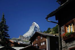
The village is situated at the end of Mattertal at an altitude of 1,620 m (5,315 ft), at the feet of Switzerland's highest peaks. It lies about 10 km (6 mi) from the over 3,300 metres high Theodul Pass bordering Italy.
Zermatt is famed as a mountaineering and ski resort of the Swiss Alps. Until the mid-19th century, it was predominantly an agricultural community; the first and tragic ascent of the Matterhorn in 1865 was followed by a rush on the mountains surrounding the village, leading to the construction of many tourist facilities.
Contents |
Etymology
The name of Zermatt, as well as that of the Matterhorn itself, derives from the alpine meadows, or matten (in German), in the valley. The name appeared first as Zur Matte ("in the meadow") and became later Zermatt. It does not appear until 1495 on a map or 1545 in a text, but may have been employed long before.
Praborno or Prato Borno are the older names of Zermatt; they appear in the ancient maps as early as the thirteenth century.[2] The French-speaking people from the Aosta Valley used this name until about 1860 in the form of Praborne, or Praborgne. The reason of this change from Praborno to Zermatt is attributed to the gradual replacement of the Romance-speaking people by German-speaking colony.[3][4]
Geography
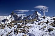
The village of Zermatt lies at the southern end of the Matter Valley (German: Mattertal), which is one of the lateral branches of the great Valley of the Rhone. The village is almost completely surrounded by the high mountains of the Pennine Alps among which Monte Rosa (or Dufourspitze), Switzerland's highest peak at 4,634 metres above sea level. It is followed by the Dom (4,545 metres), Lyskamm (4,527 metres), Weisshorn (4,505 metres) and the Matterhorn (4,478 metres). Most of the Alpine four-thousanders are located around of Zermatt or in the neighbouring valleys.
Zermatt is traversed by the main river of the valley: the Matter Vispa,[5] which takes its sources from the glaciers located at the feet of the highest peaks; the Gorner Glacier on the east side near Monte Rosa and the Zmutt Glacier on the west side between Dent d'Hérens and Dent Blanche.
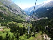
The village of Zermatt, while dense, is geographically small. There are three main streets which run along the banks of the river Matter Vispa, and numerous cross-streets, especially around the station and the church which forms the center of the village. In general anything is at most a thirty minute walk away. There are several "suburbs" within Zermatt. Winkelmatten, which was once a separate small hamlet, lies on a hill (1,670 metres) on the southern side. Steinmatten is located on the eastern bank of the main river.
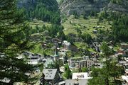
A large number of hamlet are located in the valleys above Zermatt, however they are usually not inhabited all year round. Zum See (1,766 metres) lies south of Zermatt on the west bank of the Gorner gorge, near Furi where a cable car station is located (1,867 metres). On the side of Zmutt valley (west of Zermatt), lies the hamlet of Zmutt (1,936 metres) north of the Zmuttbach river. Findeln (2,051 metres) is located in the eastern valley above the Findelbach river. It lies below the Sunnegga station (2,278 metres). Located near a train station of the Gornergrat railway, Riffelalp (2,222 metres) is one of the highest hamlets with a chapel.
The municipality has a permanent population of around 5,800 people,[6] although the actual population varies considerably through the seasons as tourists come and go.
Tourism
The town was "discovered" by mid-nineteenth century British mountaineers, most notably Edward Whymper, whose conquest of the Matterhorn made the village famous. The Matterhorn was one of the last alpine mountains to be conquered (in 1865), and the first expedition that reached the top ended dramatically with only 3 of the 7 climbers surviving the descent. The story is related in the Matterhorn Museum.
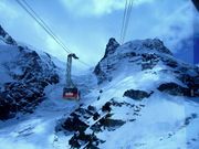
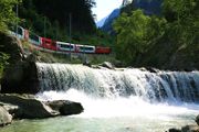
Zermatt is a starting point for hikes into the mountains, including the Haute Route that leads to Chamonix in France and the Patrouille des Glaciers. Cable cars and chair lifts carry skiers in the winter and hikers in the summer; the highest of them leads to the Klein Matterhorn at 3,883m, a peak on the ridge between Breithorn and Matterhorn that offers spectacular views in all directions. It is possible to cross into Italy via the Cervinia cable car station. A spectacular rack railway line (the Gornergratbahn, the highest open-air railway in Europe) runs up to the summit of the Gornergrat at 3,089m (10,134 ft). Zermatt is also the western terminus for the Glacier Express rail service connecting to St. Moritz and the MGB (Matterhorn-Gotthard-Bahn).
Transport
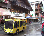
To prevent air pollution which could obscure the town's view of the Matterhorn, the entire town is a combustion-engine car-free zone. Almost all vehicles in Zermatt are battery driven and almost completely silent. Electric vehicles are allowed for local commerces. The Cantonal police can issue a permit which allows residents to drive and park at the northern outskirts. Some emergency (fire trucks, ambulances, etc.) and municipal (buses, garbage trucks, etc.) vehicles are also allowed to use combustion engines.
Passenger vehicles operating within Zermatt include tiny electric shuttles provided by hotels to carry visitors from the main train station (or the taxi transfer point just outside town) to the hotel properties, "electro" taxis operated by four major Zermatt families, and "electro" buses, which serve two routes: one between the major hotel areas and the stations of the various ski-lifts, and the other following a similar route but also serving the more rural "suburb" of Winkelmatten. Horse-drawn carriages can also be found; some are operated by hotels and others are available for hire.
Most visitors reach Zermatt by cog railway train from the nearby town of Täsch (Zermatt shuttle). Trains also depart for Zermatt from farther down the valley at Visp and Brig, which are on the main Swiss rail network. The town also has a heliport (ICAO: LSEZ) and a local helicopter operator, Air Zermatt, which also provides alpine rescue services.
In 2007, a project group was formed to evaluate options for development of the local transportation network (as the "electro" buses do not have enough capacity). The results of this study are published in the December 2007 edition of Zermatt Inside. The six options explored are a coaster, a funicular, a metro, moving sidewalks, a gondola or more "electro" buses.[7]
Skiing
Zermatt is known throughout the world for its skiing, especially Triftji for its moguls. The high altitude results in consistent skiing continuously up until the summer.
Skiing in Zermatt is split up into four areas; Sunnegga, Gornergrat, Klein Matterhorn and Schwarzsee. There is also a connection to Cervinia and Valtournenche in Italy.[8][9]
In 2008, Zermatt hosted an 'Infinity Downhill Race'. The race took place on the 13 and 14 December and comprised a course descending from the Matterhorn Glacier Paradise (3,800 m (12,500 ft)) and finished in Zermatt itself (1,600 m (5,200 ft)). The course was 20 km long and featured a 2,200 m descent.[10]
Sunnegga
The Sunnegga Paradise is accessed via a funicular railway, followed by a gondola to Blauherd and finally a cable car onwards to the Rothorn (3,103m) above. The topography of the mountain and the valley tends to keep the Rothorn clear and sunny, even when Zermatt is submerged in cloud.
From Blauherd there is a gondola down to Gant, and from there a connecting cablecar goes to Hohtälli. This cable car and the newer 4-seat chairlift Sunnegga-Findeln-Breitboden provide connections between Sunnegga and Gornergrat. With few steep slopes, this mountain is often used to train younger skiers.
Gornergrat
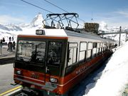
The Gornergrat is served by the Gornergratbahn railway, a 29 minute ride to the Gornergrat peak (3,089 m), via Riffelalp, Rotenboden and Riffelberg, (with limited stops at Findelbach and Landtunnel just above the town). At the summit, the hotel and restaurant have been refurbished and accommodate a shopping centre.
A cable car heads up from Hohtälli to the Rote Nase (3,247 m). This final lift serves a freeride area but can be unreliable as this mountainside requires high snow cover to be skiable. The lifts in this area generally open for the season in late February or early March, depending upon the snowfall. In 2008 a new T-bar tow re-opened access to the Stockhorn.
The old Hohtälli to Gornergrat cablecar is now permanently closed, with no replacement lift planned. A new slope leading back from Hohtälli to Kellensee just under the Gornergrat replaced this lift to maintain the link from the Rothorn to Gornergrat.
Klein Matterhorn / Schwarzsee
Near the southern end of Zermatt, the Matterhorn Express gondola transports passengers up to the interchange station at Furi. From here there is access to the Schwarzsee via a gondola to the right, a cable car that leads on to the Trockener Steg midstation (and then on to the Klein Matterhorn), and a new gondola, opened on 18 December 2006, links Furi to Riffelberg on the Gornergrat mountain. This lift addresses one of the most persistent criticisms of Zermatt: that it is very difficult to ski the two sides of the valley without a tiresome trek through the village between the Gornergratbahn and the Matterhorn Express at opposite ends of the town.
Testa Grigia at the top of the Theodulpass serves as a connection to the Italian ski-resorts of Cervinia and Valtournenche. From the Swiss side it is only reachable by skilift, but from the Italian side by a chairlift and by a cablecar. There are customs offices here as well as a small alpine museum.
Zermatt is marketed as an all year skiing resort, with summer skiing limited to the Theodulgletscher behind the Klein Matterhorn. Whilst strictly true, during the off season in May and June there will only tend to be one or two runs open, and the main glacier area does not open until July.
In operation since 25 October 2003, the Furggsattel six-seater chairlift has twelve (of eighteen) masts that stand directly on the glacial ice of the Theodulgletscher - a first for Switzerland. It is one of very few lifts worldwide with bottom- and top-station in different countries, respectively Switzerland and Italy.
History of the lift system
- 1898 Start of summer operation of Gornergratbahn.
- 1928 Gornergratbahn introduces a twice daily winter sports service to Riffelalp.
- 1939 Development of Theodul area from Breuil Cervinia to Testa Grigia.
- 1942 Zermatt-Sunnegga skilift (summer: foot lift, replaced by chairlift in 1967).
- 1946 Weisti trainer skilift (moved to Riffelberg in 1969). Zermatt-Sunnegga sideways facing chairlift (replaced by funicular in 1980).
- 1947 Sunnegga-Blauherd skilift (replaced by cable car in 1967).
- 1955 Cableway Plan Maison-Furgghorn (discontinued 1992).
- 1956 Suspension lift Gornergrat-Hohtälli (due to be discontinued in the summer of 2007). Skilift Riffelberg (replaced by chairlift 2003). Skilift Furi (discontinued 1960). Chairlift Findeln-Sunegga (due to be replaced in the summer of 2007).
- 1957 Suspension lift Zermatt-Furi.
- 1958 Suspension lift Hohtälli-Stockhorn (due to be discontinued in the summer of 2007). Furi-Schwarzsee suspension lift (replaced by cable car lift 2002).
- 1960 Skilift Garten (discontinued 2003).
- 1962 Suspension lift Furgg-Schwarzsee (replaced by group turnaround lift in 1991).
- 1963 Skilift Hornli.
- 1964 Suspension lift Furi-Furgg (replaced by Matterhorn Express in 2002). Theodullift (replaced by extension of Gandegglift 2003). Skilift Triftji-RoteNase
- 1965 Furgg-Trockener Steg suspension lift. Skilift National (replaced by chairlift Patrullarve 1989).
- 1967 Cable car lift Sunnegga-Blauherd (replaced by combi system in 2005). Suspension lift Blauherd-Rothorn (replaced in 1996). Skilift Furgsattel (replaced by chairlift in 2003). Skilift Eisfluh (replaced by chairlift 2001). Passlift (replaced by extension to Gandegglift 2003).
- 1968 Platform skilift Kumme (replaced by chairlift 1982). Skilift Gandegg (extended and renewed in 2003).
- 1971 Cablecar Gant-Blauherd. Skilift Gant-Platte (discontinued 2002). Skilift Riffelberg-Gifthittli (replaced by chairlift 2003). Skilift Test Grigia 1.
- 1979 Suspensionlift Trockener Steg-Klein Matterhorn.
- 1980 Funicular Zermatt-Sunnegga. Skilift Testa Grigia 2 (moved to Plateau Rosa 3 2005). Border skilift (Gobba di Rollin). Skilift Plateau Rosa 1.
- 1982 Suspension lift Furi-Trockener Steg. Cable car Zermatt-Furi. Chairlift Kumme-Rothorn.
- 1984 Joint skipass in Zermatt.
- 1986 Suspension lift Hohtälli-Rote Nase.
- 1989 Chairlift Patrullarve-Blauherd.
- 1991 Chairlift Furgg-Sandiger Boden-Theodul Glacier. Skilift Plateau Rosa 2. Group turnaround lift Furgg-Schwazsee.
- 1995 Joint skipass Zermatt-Cervinia.
- 1996 Suspension lift Blauherd-Rothorn.
- 1998 Suspension lift Gant-Hohtälli.
- 1999 Electronic ticketing system introduced.
- 2001 Chairlift Eisfluh-Sunnegga.
- 2002 Merger of Zermatt Bergbahnen. Cable car lifts Matterhorn Express (Zermatt-Furi-Schwarzsee).
- 2003 Chairlift Furgsattel Gletcherbahn. Chairlift Gifthittli.
- 2005 Combi system (car/chair) Sunnegga-Blauherd. Passenger lift funicular-Riedweg.
- 2006 Suspension lift Furi-Schweigmatten-Riffelberg.
- 2007 End of operations of the Gornergrat - Hohtälli tram, replaced by a red slope Hohtälli - Kellensee.
- 2007 End of operations of the Hohtälli - Stockhorn tram, replaced by a surface lift in 2008.
- 2007 Clearing of the skitunnel at Riffelberg, increasing the capacity of this slope.
- 2007 4-seat chairlift Sunnegga-Findeln-Breitboden.
Developments
The Zermatt Bergbahnen's website[11] mentions a few projects for the following years:
- 2010 Chairlift at Garten (Furgg), replacing an old surface lift.
- 2011 Cable car Testa Grigia-Klein Matterhorn.
As well as several changes to the slopes, and the placement of new snowmaking installations.
Weather
| Climate data for Zermatt | |||||||||||||
|---|---|---|---|---|---|---|---|---|---|---|---|---|---|
| Month | Jan | Feb | Mar | Apr | May | Jun | Jul | Aug | Sep | Oct | Nov | Dec | Year |
| Average high °C (°F) | 0.2 (32.4) |
1.3 (34.3) |
3.7 (38.7) |
7.3 (45.1) |
12.1 (53.8) |
15.6 (60.1) |
18.9 (66) |
17.9 (64.2) |
15.4 (59.7) |
11.2 (52.2) |
4.6 (40.3) |
1.1 (34) |
9.1 (48.4) |
| Daily mean °C (°F) | -4.8 (23.4) |
-4 (25) |
-1.5 (29.3) |
2 (36) |
6.7 (44.1) |
10 (50) |
12.5 (54.5) |
11.7 (53.1) |
9 (48) |
4.8 (40.6) |
-0.8 (30.6) |
-3.8 (25.2) |
3.5 (38.3) |
| Average low °C (°F) | -8.4 (16.9) |
-7.8 (18) |
-5.5 (22.1) |
-2.2 (28) |
2.1 (35.8) |
4.8 (40.6) |
6.8 (44.2) |
6.7 (44.1) |
4.2 (39.6) |
0.7 (33.3) |
-4 (25) |
-7.1 (19.2) |
-0.8 (30.6) |
| Precipitation mm (inches) | 43 (1.69) |
46 (1.81) |
49 (1.93) |
50 (1.97) |
61 (2.4) |
56 (2.2) |
47 (1.85) |
60 (2.36) |
41 (1.61) |
55 (2.17) |
55 (2.17) |
49 (1.93) |
611 (24.06) |
| Avg. precipitation days | 6.6 | 6.3 | 7.7 | 6.7 | 10 | 8.6 | 8.9 | 9.9 | 6.9 | 6.7 | 7 | 6.7 | 92 |
| Source: MeteoSchweiz [12] | |||||||||||||
See also
- Matterhorn Museum
- List of ski areas and resorts in Switzerland
- Swiss Alps
References
- Swisstopo maps
- ↑ Swiss Federal Statistical Office, MS Excel document – Bilanz der ständigen Wohnbevölkerung nach Kantonen, Bezirken und Gemeinden (German) accessed 25 August 2010
- ↑ W. A. B. Coolidge, " Swiss Travels and Guide Books," p. 255
- ↑ The names of Zermatt, W. A. B. Coolidge
- ↑ Rey, Guido, The Matterhorn, p. 290
- ↑ The Matter Vispa originates from the Zmuttbach, Gornera and Findelbach
- ↑ Bundesamt fur Statistik (Federal Department of Statistics) (2008). "Bilanz der ständigen Wohnbevölkerung (Total) nach Bezirken und Gemeinden". http://www.bfs.admin.ch/bfs/portal/de/index/themen/01/02/blank/key/raeumliche_verteilung/kantone__gemeinden.html. Retrieved November 5, 2008.
- ↑ "Zermatt Inside". Zermatt. http://inside.zermatt.ch.
- ↑ Trail Map 2007/08
- ↑ ski-zermatt.com
- ↑ The world's biggest drop snowskiing.com
- ↑ "Planned Projects (Zermatt Bergbahnen)". ZBAG. http://web.archive.org/web/20080822080201/http://bergbahnen.zermatt.ch/e/about-us/projekte/. Retrieved 2008-02-24.
- ↑ "Temperature and Percipitation Average Values-Table, 1961-1990" (in German, French, Italian). Federal Office of Meteorology and Climatology MeteoSwiss. http://www.meteoswiss.admin.ch/web/de/klima/klima_schweiz/tabellen.html. Retrieved 8 May 2009.
External links
| Wikisource has the text of the 1920 Encyclopedia Americana article Zermatt. |
- Zermatt.ch Official website
- Air Zermatt website (German)
- Municipality of Zermatt (German)
- Burgergemeinde Zermatt (German)
- Webcams in Zermatt
- Photo gallery (English)
- Images from Zermatt
- Live Webcam Zermatt
- Zermatt travel guide from Wikitravel
|
|||||||
|
|||||||||||