Zugspitze
| Zugspitze | |
|---|---|
 |
|
| Elevation | 2,962 m (9,718 ft) |
| Prominence | 1,746 m (5,728 ft) |
| Listing | Country high point Ultra |
| Pronunciation | [German: [ˈtsuːk.ʃpɪtsə]] |
| Location | |
| Range | Wetterstein |
| Topo map | BEV ÖK50 116 |
| Climbing | |
| First ascent | 1820 by G. Deutschl, Maier and J. Naus |
| Easiest route | through the Reintal to the Knorrhütte and across the plateau |
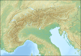
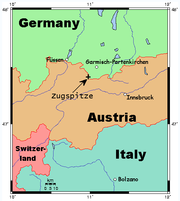
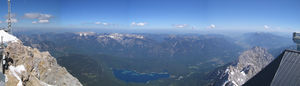
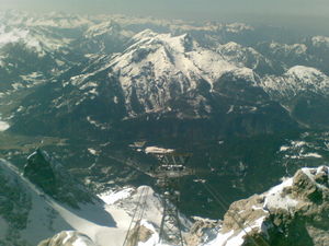
The Zugspitze is the highest mountain in Germany, at 2,962 metres above sea level. It is located on the Austrian border beside the town of Grainau in the district of Garmisch-Partenkirchen, in the federal-state of Bavaria. On the Austrian side lies the town of Ehrwald in the district of Reutte, Tyrol. There is a cog railway (Zugspitzbahn) leading from the tourist resort of Garmisch-Partenkirchen to the Zugspitzplatt from where a cable car runs to the peak. There are also two cable cars that go to the peak from the base of the mountain: one ascends from the German side of the mountain at the lake Eibsee (Eibsee Cable Car), and the other ascends from Austria near Ehrwald (Tyrolean Zugspitze Cable Car). The peak is regularly crowded with tourists.
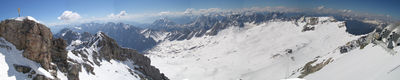
For those wishing to reach the summit under their own power, various hiking and ski trails can also be followed to the top. Hiking to the top from the base takes between one and two days, or a few hours for the very fit. Food and lodging is available on some trails. In winter the Zugspitze is a popular skiing and snowboarding destination, with several slopes on both sides. The Zugspitzplatt is Germany's highest ski resort, and thus normally has sufficient snow throughout the winter.
The border between Germany and Austria goes right through the mountain. There used to be a border checkpoint at the summit. But since Germany and Austria are now both part of the Schengen zone, the border crossing is no longer staffed.
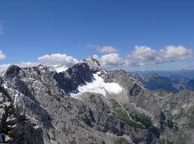
The Zugspitze belongs to the Wetterstein range in the Northern Limestone Alps. It gets its name from the many avalanche passages (Lawinenzüge in German) on its steep north slopes.
At the Zugspitze's summit is the Münchner Haus, a mountain hut (Alpenvereinshütte), a facility built by the German Alpine Club (Deutscher Alpenverein). For more than a hundred years, the summit has also had a weather station, which nowadays also gathers data for the Global Atmosphere Watch.
Shortly after World War II the US military took over the Schneefernerhaus (as the hotel at the top was then called) for the exclusive use of US military and civilian employees. Room rates, including meals, were US $ 1 per day. Ski lessons were available, taught by Austrians and Germans, at a cost of US $ 0.25 per hour.
The first recorded ascent to the summit was accomplished by a team of land surveyors on the 27th of August, 1820. The team was led by Lieutenant Josef Naus, who was accompanied by two men named Maier and G. Deutschl. However, local people had conquered the peak over 50 years earlier, according to a 1770 map discovered by the Alpenverein.[1]
On 7 January 1882 the first successful winter assault on the Zugspitze was accomplished by F. Kilger, H. and J. Zametzer and H. Schwaiger.
Climbing up the Zugspitze can involve several routes. The large difference in elevation between Garmisch-Partenkirchen and the summit is 2 200 m, making the climb a challenge even for trained mountaineers.
On the German side, from Garmisch-Partenkirchen, climbers go either through the Höllental ("Valley of Hell") or the Reintal. The way through the Reintal is the easiest, but also the longest and takes 8 to 10 hours. This path goes through the Partnachklamm, a scenic gorge, then through the Reintal up to the Zugspitzplatt, a barren plateau. from there up to the summit. Climbers can stay for the night at two alpine huts, the "Reintalangerhütte" or the "Knorrhütte".
The more popular, but harder route is through the Höllental. It starts at Hammersbach near Garmisch, goes through the Höllentalklamm, a similar gorge up to the "Höllentalangerhütte", where one can take a meal or stay for the night. It then crosses the Höllentalferner, the remnants of a small glacier. After that it traverses a wall with the help of iron ladders and steps. Via ferrata equipment is recommended for that part. Over the Irmerscharte (a gap) it reaches the summit. This path will take 7 to 8 hours.
From the Austrian village of Ehrwald, there are also two variants. One goes straight through the Western Flank, which is the shortest route overall, but rather hard. It includes a via ferrata, and there is a hut called "Wiener Neustädter Hütte" by the Austrian Alpine Club. An easier path leads via the Ehrwalder Alm, across a small pass called "Gatterl", joining the Reintal path at the Knorrhütte.
The Zugspitze's exact height was a matter of debate for quite a while. Given figures ranged from 2 960 m to 2 970 m, but it is now generally accepted that the peak is 2 962 m above sea level as a result of a survey carried out by the Bavarian land survey office. The lounge at the new café is named "2962" for this reason.
References
- ↑ Harding, Luke (21 September 2006). "Locals had climbed peak before it was 'conquered'". London: The Guardian. http://www.guardian.co.uk/international/story/0,,1877123,00.html. Retrieved 20 April 2010.
External links
- Zugspitze on Distantpeak.com
- More comprehensive article about the Zugspitze in German Wikipedia
- Computer generated summit panoramas North South Index
- Bayerische Zugspitzbahn Bergbahn AG - Transportation to the mountain top and local webcams
|
|||||||||||||||||||||||||||||