Žilina
| Žilina | |||
| City | |||
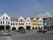
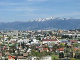 Žilina City skyline
|
|||
|
|||
| Country | |||
|---|---|---|---|
| Region | Žilina | ||
| District | Žilina | ||
| Tourism region | Horné Považie | ||
| Rivers | Váh, Rajčanka, Kysuca | ||
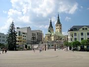
| Center | Andrej Hlinka Square | ||
| - elevation | 342 m (1,122 ft) | ||
| - coordinates | |||
| Area | 80.03 km² (30.9 sq mi) | ||
| Population | 85,302 (2009-05-31) | ||
| - urban | 108,114 | ||
| - metro | 159,729 | ||
| Density | 1,066 / km² (2,761 / sq mi) | ||
| First mentioned | 1069 | ||
| Mayor | Ivan Harman | ||
| Timezone | CET (UTC+1) | ||
| - summer (DST) | CEST (UTC+2) | ||
| Postal code | 010 01 | ||
| Area code | +421-41 | ||
| Car plate | ZA | ||
  Location in Slovakia
|
|||
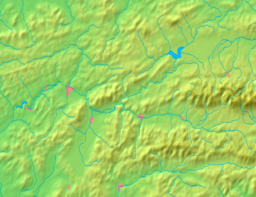  Location in the Žilina Region
|
|||
| Wikimedia Commons: Žilina | |||
| Statistics: MOŠ/MIS | |||
| Website: www.zilina.sk | |||

Žilina (pronunciation; German: Sillein, Hungarian: Zsolna, names in other languages) is a city in north-western Slovakia, around 200 kilometres (120 mi) from the capital Bratislava. It is the fourth largest city of Slovakia with a population of around 85,000, an important industrial centre, the largest city on the Váh river, and the seat of a kraj (Žilina Region) and of an okres (Žilina District). It belongs to Upper Váh region of tourism.
Contents |
History
The area around today's Žilina was inhabited in the late Stone Age (around 20 000 BC). In the 5th century Slavs started to move into the area. However, the first written reference to Žilina was in 1208 as terra de Selinan. From the second half of the 10th century until 1918, it was part of the Kingdom of Hungary.
In the middle of the 13th century as terra Sylna it was property of the Cseszneky de Milvány family.[1] The city started to develop around year 1300, and according to records in 1312 it was already a town. In 1321, King Charles I made Žilina a free royal town. On 7 May 1381 King Louis I issued Privilegium pro Slavis which made the Slav inhabitants equal to the Germans by allocating half of the seats at the city council to Slavs.[2] The town was burned in 1431 by the Hussites.
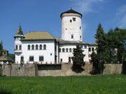
During the 17th century, Žilina gained position as a centre of manufacturing, trade and education and during the baroque age many monasteries and churches were built as well as the Budatín Castle. In the Revolutions of 1848, Slovak volunteers, part of the Imperial Army, won a battle near the city against Hungarian honveds and gardists.
The city boomed in the second half of the 19th century as new railway tracks were built: the Kassa Oderberg Railway was finished in 1872 and the railway to Pozsony in 1883, and new factories started to spring up, for example the drape-producing factory Slovena (1891) and the Považie chemical works (1892).
It was one of the first municipalities to sign the Martin Declaration (30 October 1918), and until March 1919 it was the seat of the Slovak government. On 6 October 1938, shortly after the Munich Agreement, autonomy of Slovakia within Czechoslovakia was declared in Žilina.
After the Second World War, the city experienced a boom, with many new factories, schools, and housing estates being built. It was the seat of the Žilina Region from 1949–1960 and again since 1996.
Today Žilina is the fourth largest city in Slovakia, the third most important industrial centre and the seat of a university, the Žilinská univerzita (founded in 1953). Since 1990 the historical centre of the city has been largely restored and the city has built trolleybus lines.
Geography
Žilina lies at an altitude of 342 metres (1,122 ft) above sea level and covers an area of 80.03 square kilometres (30.9 sq mi).[3] It is located in the Upper Váh region (Slovak: Horné Považie) at the confluence of three rivers: Váh, flowing from east into south-west, Kysuca, flowing from north and Rajčanka rivers from south, in the Žilina Basin. The city is surrounded by these mountain ranges: Malá Fatra, Súľovské vrchy, Javorníky and Kysucká vrchovina. Protected areas nearby include: Strážov Mountains Protected Landscape Area, Kysuce Protected Landscape Area and Malá Fatra National Park. There are two hydroelectric dams on the Váh river around Žilina: the Žilina dam in the East and the Hričov dam in the West.
Climate
Žilina lies in the north temperate zone and has a continental climate with four distinct seasons. It is characterized by a significant variation between hot summers and cold, snowy winters. Average temperature in July is 18 °C (64 °F), in January −4 °C (24.8 °F). Average annual rainfall is 650 – 700 mm (25.5–27.5 in), most of the rainfall is in June and in the first half of July. Snow cover lasts from 60 to 80 days per year.
| Climate data for Žilina | |||||||||||||
|---|---|---|---|---|---|---|---|---|---|---|---|---|---|
| Month | Jan | Feb | Mar | Apr | May | Jun | Jul | Aug | Sep | Oct | Nov | Dec | Year |
| Average high °C (°F) | 0 (33) |
3 (38) |
8 (47) |
14 (58) |
20 (68) |
22 (72) |
25 (76) |
25 (77) |
20 (67) |
14 (58) |
6 (44) |
1 (35) |
13.2 (56.1) |
| Average low °C (°F) | -5 (22) |
-5 (23) |
-1 (30) |
3 (37) |
8 (46) |
10 (51) |
12 (54) |
12 (53) |
9 (47) |
5 (41) |
0 (33) |
-4 (26) |
3.7 (38.6) |
| Precipitation cm (inches) | 2.85 (1.12) |
2.67 (1.05) |
3.10 (1.22) |
4.08 (1.61) |
4.82 (1.90) |
6.99 (2.75) |
6.84 (2.69) |
5.19 (2.04) |
4.74 (1.87) |
4.19 (1.65) |
3.91 (1.54) |
3.42 (1.35) |
52.8 (20.79) |
| Source: MSN Weather[4] | |||||||||||||
Symbol
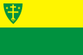
The coat-of-arms of Žilina is a golden double-cross (so-called cross of Lorraine) with roots and two golden stars on the olive-green background. The double-cross is of Byzantine origin and stems from Cyrillic-methodic tradition. The coat-of-arms is one of the oldest municipal coat-of-arms not only in Slovakia. It has been used as the city's symbol since 1378.
Demographics
| Municipality | Urban | Metro |
|---|---|---|
| Žilina | 85,302 | 85,302 |
| Kysucké Nové Mesto | - | 16,420 |
| Varín | - | 3,537 |
| Teplička nad Váhom | 3,502 | 3,502 |
| Belá | - | 3,361 |
| Rajecké Teplice | - | 2,950 |
| Rosina | 2,925 | 2,925 |
| Strečno | - | 2,661 |
| Višnové | 2,610 | 2,610 |
| Divina | - | 2,483 |
| Dlhé Pole | - | 2,029 |
| Turie | 1,981 | 1,981 |
| Kamenná Poruba | - | 1,826 |
| Stráňavy | - | 1,822 |
| Lietavská Lúčka | 1,786 | 1,786 |
| Rudina | - | 1,669 |
| Lietavská Svinná - Babkov | - | 1,596 |
| Dolný Hričov | 1,506 | 1,506 |
| Lietava | 1,422 | 1,422 |
| Radoľa | - | 1,391 |
| Konská | - | 1,393 |
| Dolná Tižiná | - | 1,243 |
| Gbeľany | 1,239 | 1,239 |
| Krasňany | 1,223 | 1,223 |
| Snežnica | - | 1,013 |
| Svederník | 1,003 | 1,003 |
| Kunerad | - | 949 |
| Nededza | 927 | 927 |
| Divinka | - | 882 |
| Lysica | - | 864 |
| Lutiše | - | 795 |
| Podhorie | - | 781 |
| Horný Hričov | - | 763 |
| Hôrky | 635 | 635 |
| Bitarová | 630 | 630 |
| Ovčiarsko | 511 | 511 |
| Brezany | 462 | 462 |
| Mojš | 450 | 450 |
| Porúbka | - | 447 |
| Rudina | - | 384 |
| Nezbudská Lúčka | - | 366 |
| Total | 108,114 | 159,729 |
Žilina has a population of 85,302 (as of May 31, 2009), population of urban area: 108,114 and population of metro area: 159,729. According to the 2001 census, 96.9% of inhabitants were Slovaks, 1.6% Czechs, 0.2% Roma, 0.1% Hungarians and 0.1% Moravians. The religious makeup was 74.9% Roman Catholics, 16.7% people with no religious affiliation, and 3.7% Lutherans.[3]
Economy
Žilina is the main industrial hub of upper Váh river basin region with fast growing economic importance as North-West Slovakia business centre with large retail and construction sector.
By far the biggest and most important employer is Korean car producer Kia Motors. By 2009, the car plant produced 300,000 cars a year and employed up to 3000 employees. Kia motors direct investments in Žilina car plant amounts to over 1.5 billion USD. As for year 2009 the Zilina car plant producing Kia cee’d, Kia Sportage and Hyundai ix35 car models. Kia motors further upgrading its capacities to be ready to produce engines for a sister company Hyundai allocated nearby Ostrava in the Czech republic with planning investment 200 million USD.
Žilina is also seat of biggest Slovakia construction and transportation engineering corporation Vahostav. Chemical industry is represented by Považské chemické závody and Tento, a paper mill company.
Culture and sights
Theatres
There are two theatres in Žilina: the City Theatre [1], and the Puppet Theatre [2]
Museums
There are three museums in Žilina:
- Považská galéria (Museum of Art Žilina) [3]
- Považské múzeum (Považie museum), in the Budatín castle
- Múzeum židovskej kultúry (Museum of Jewish culture)
Sights
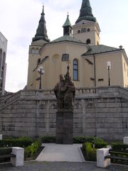
The historical centre of the city, reconstructed in the early 1990s is protected as a city monument reserve (Slovak: Mestská pamiatková rezervácia), It is centred on the Mariánske námestie and Andrej Hlinka squares. The Mariánske námestie square has 106 arcade passages and 44 burgher houses along the whole square.[5] It is dominated by the Church of St. Paul the Apostle, the old building of the city council, and the baroque statue of the Virgin Mary. Nearby is the Church of the Holy Trinity, a sacral building built around 1400, which is since February 2008 the cathedral of the Diocese of Žilina. Other landmarks in and around the city include:
- Budatín Castle, housing Považie Museum with tinker trade exhibition
- The wooden Roman Catholic church of St. George in the city part of Trnové (one of the few outside north-eastern Slovakia)
- The Church of St. Stephen the King, the oldest architectural landmark in Žilina
- The Orthodox synagogue, which now houses the Museum of Jewish culture
In addition, the city is a starting point for various locations of western and eastern Slovakia, including hiking trails into the Lesser Fatra and Greater Fatra mountains. Other locations of interest include Bojnice Castle, Strečno, Orava region, and the villages of Čičmany and Vlkolínec.
 Považská galéria |
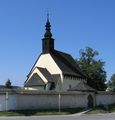 The Church of St. Stephen the King |
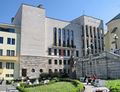 City Theatre |
Sport
Football (soccer) club MŠK Žilina plays the top Slovak division Corgoň liga and is one of the most successul teams in recent years having won five domestic titles and three runner-ups in the period between 2001-2010. Home games are played at the Stadium Pod Dubňom which is situated at the edge of city centre in the neighbourhood of ice hockey stadium.
Ice hockey club MsHK Žilina plays in the Slovak Extraliga. They have won one domestic title so far.
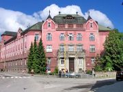
Government
The city is governed by a mayor (Slovak: primátor) and a city council (Slovak: mestské zastupiteľstvo). The mayor is the head of the city and its chief executive, with the term of office lasting four years. The current mayor, Ivan Harman, was nominated in 2006 by a coalition of the political parties SDKÚ-DS, KDH, SF and OKS. The council is the city's legislative body, with 31 councillors. The last municipal election was held in 2006 and councillors are elected to four-year terms concurrent with the mayor's. Žilina is divided into eight electoral districts, consisting of the following neighbourhoods:[6]
- Staré mesto, Hliny I-IV, Hliny VIII (5 councillors)
- Hliny V-VII, Bôrik (4 councillors)
- Solinky (5 councillors)
- Vlčince (6 councillors)
- Hájik (3 councillors)
- Bytčica, Rosinky, Trnové, Mojšová Lúčka (2 councillors)
- Závodie, Bánová, Strážov, Žilinská Lehota (2 councillors)
- Budatín, Považský Chlmec, Vranie, Brodno, Zádubnie, Zástranie (3 councillors)
Žilina is the capital of one of eight considerably autonomous Regions of Slovakia.[7] It is also the capital of a smaller district. The Žilina District (Slovak: okres Žilina) is nested within the Žilina Region. The city also hosts a regional branch of National Bank of Slovakia.
Education
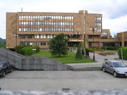
The city is home to the University of Žilina, which has seven faculties and has 12,402 students, including 625 doctoral students.[8]
There are 18 public primary schools, one private primary school, and three church primary schools.[9] Overall, they enroll 7,484 pupils.[9] The city's system of secondary education (some middle schools and all high schools) consists of eight gymnasia with 3,514 students,[10] ten specialized high schools with 3,696 students,[11] and nine vocational schools with 4,870 students.[12][13]
Transport
The city is an important international road and rail junction. Railroads and roads connect the city with Bratislava and Prievidza in the south, Čadca in the north, and Martin in the east. The construction of the D1, and D3 motorways and their feeders continues towards Žilina. Žilina is also served by international Žilina Airport, which is some 10 km away from the city centre.
Public transport within the city is operated by DPMZ and consists of buses (since 1949) and trolleybuses (since 1994).
.jpg) Trolleybus transport |
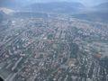 Aerial view of Žilina |
People
- Tomáš Bezdeda, singer
- Ľubomír Feldek, Slovak poet
- Stanislav Griga, football coach
- Juraj Jánošík, Slovak national hero
- Karol Križan, ice hockey player
- David Leimdörfer, rabbi
- Marek Mintál, football (soccer) player
- Peter Pekarik, football player
- Ronald Petrovický, ice hockey player
- Peter Sagan, cyclist
- Ján Slota, Slovak nationalist politician and former mayor of Žilina
- Martin Šulík, actor
- Miroslav Šustek, writer
- Viktor Tausk, psychoanalyst
- Radoslav Židek, snowboarder, first medal winner at the Winter Olympic Games from Slovakia
International relations
Twin towns - Sister cities
Žilina has several twin towns around the world:[14]
References
Notes
- ↑ Monumenta Hungariae historica
- ↑ Kirschbaum, Stanislav J. (1995). A history of Slovakia : the struggle for survival. New York: St. Martin’s Press.
- ↑ 3.0 3.1 "Municipal Statistics". Statistical Office of the Slovak republic. http://www.statistics.sk/mosmis/eng/run.html. Retrieved 2007-12-23.
- ↑ "Monthly Averages for Žilina, Slovakia". MSN. http://weather.msn.com/monthly_averages.aspx?&wealocations=wc%3a37602&setunit=C. Retrieved 18 January 2008.
- ↑ Spectacular Slovakia 2004: Žilina and Northern Slovakia, the Malá Fatra mountains
- ↑ "Členovia Mestského zastupiteľstva" (in Slovak). http://www.zilina.sk/mesto-zilina-samosprava-mestske-zastupitelstvo-clenovia-zastupitelstva. Retrieved 2007-12-23.
- ↑ Brusis, Martin (2002). "Between EU Requirements, Competitive Politics, and National Traditions: Re-creating Regions in the Accession Countries of Central and Eastern Europe". Governance 15 (4): 531–559. doi:10.1111/1468-0491.00200.
- ↑ "Žilinská univerzita" (in Slovak) (PDF). Ústav informácií a prognóz školstva. http://www.uips.sk/statis/pdf/VS_P28.PDF. Retrieved 2008-02-15.
- ↑ 9.0 9.1 "Prehľad základných škôl v školskom roku 2006/2007" (in Slovak) (PDF). Ústav informácií a prognóz školstva. 2006. http://www.uips.sk/statis/pdf/ZS_P5.PDF. Retrieved 2008-02-15.
- ↑ "Prehľad gymnázií v školskom roku 2006/2007" (in Slovak) (PDF). Ústav informácií a prognóz školstva. http://www.uips.sk/statis/pdf/GYM_P5.PDF. Retrieved 2008-02-15.
- ↑ "Prehľad stredných odborných škôl v školskom roku 2006/2007" (in Slovak) (PDF). Ústav informácií a prognóz školstva. http://www.uips.sk/statis/pdf/SOS_P5.PDF. Retrieved 2008-02-15.
- ↑ "Prehľad združených stredných škôl v školskom roku 2006/2007" (in Slovak) (PDF). Ústav informácií a prognóz školstva. http://www.uips.sk/statis/pdf/ZSS_P5.PDF. Retrieved 2008-02-15.
- ↑ "Prehľad stredných odborných učilíšť a učilíšť v školskom roku 2006/2007" (in Slovak) (PDF). Ústav informácií a prognóz školstva. http://www.uips.sk/statis/pdf/SOU_P5.PDF. Retrieved 2008-02-15.
- ↑ "Žilina - oficiálne stránky mesta: Partnerské mestá Žiliny [Žilina: Official Partner Cities"]. © 2008 MaM Multimedia, s.r.o... http://www.zilina.sk/mesto-zilina-o-meste-partnerske-mesta. Retrieved 2008-12-11.
- ↑ "Bielsko-Biała - Partner Cities". © 2008 Urzędu Miejskiego w Bielsku-Białej.. http://www.um.bielsko.pl/. Retrieved 2008-12-10.
External links
- Official site
- DPMZ - Public Transport Official Site
- Map & information system of Zilina
- Panorama photos on 360cities
Žilina travel guide from Wikitravel
|
|||||||
|
|||||||