2007 Atlantic hurricane season
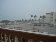
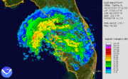
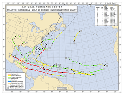 Season summary map |
|
| First storm formed: | May 9, 2007 |
|---|---|
| Last storm dissipated: | December 13, 2007 |
| Strongest storm: | Dean – 905 mbar (hPa) (26.74 inHg), 175 mph (280 km/h) |
| Total depressions: | 17 |
| Total storms: | 15 |
| Hurricanes: | 6 |
| Major hurricanes (Cat. 3+): | 2 |
| Total fatalities: | 394 direct, 29 indirect |
| Total damage: | ~ $3 billion (2007 USD) |
| Atlantic hurricane seasons 2005, 2006, 2007, 2008, 2009 |
|
| Related articles: | |
|
|
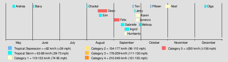
The 2007 Atlantic hurricane season was an active Atlantic hurricane season that produced 17 tropical cyclones, 15 tropical storms, 6 hurricanes, and 2 major hurricanes. It officially started on June 1 and ended on November 30, dates which conventionally delimit the period during which most tropical cyclones form in the Atlantic Ocean. The first tropical cyclone, Subtropical Storm Andrea developed on May 9, while the last storm, Tropical Storm Olga, dissipated on December 13. The most intense hurricane, Dean, is tied for the seventh most intense Atlantic hurricane ever recorded as well as the third most intense Atlantic hurricane at landfall. The season was one of only four on record for the Atlantic with more than one Category 5 storm. It was the second on record in which an Atlantic hurricane, Felix, and an eastern Pacific hurricane, Henriette, made landfall on the same day. September had a record-tying eight storms, although the strengths and durations of most of the storms were low. Aside from Dean and Felix, none of the storms exceeded Category 1 intensity.
Pre-season forecasts by the Colorado State University (CSU) called for 14 named storms and 7 hurricanes, of which 3 were expected to attain major hurricane status. The National Oceanic and Atmospheric Administration (NOAA) later issued its initial forecast, which predicted 13 to 17 named storms, 7 to 10 hurricanes and 3 to 5 major hurricanes. After several revisions in the projected number of storms, NOAA and CSU lowered their forecasts by the middle of the season.
Several storms made landfall or directly affected land. Hurricanes Dean and Felix made landfall at Category 5 intensity, causing severe damage in parts of Mexico and Central America, respectively. Both storm names, as well as Noel, the name of a hurricane that affected the Caribbean, were retired from the naming list of Atlantic hurricanes. The United States was affected by five cyclones, although the storms were generally weak; three tropical depressions and only one tropical storm, Gabrielle, and one hurricane, Humberto, made landfall in the country. Elsewhere, three storms directly affected Canada, although none severely. The combined storms killed at least 423 people and caused about $3 billion (2007 USD) in damage.[nb 1]
Contents |
Seasonal forecasts
Noted hurricane experts Philip J. Klotzbach, William M. Gray, and their associates at Colorado State University issue forecasts of hurricane activity each year, separately from NOAA. Klotzbach's team, formerly led by Gray, determined the average number of storms per season between 1950 and 2000 to be 9.6 tropical storms, 5.9 hurricanes, and 2.3 major hurricanes (storms exceeding Category 3 on the Saffir-Simpson Hurricane Scale). A normal season, as defined by NOAA, has 9 to 12 named storms, of which 5 to 7 reach hurricane strength and 1 to 3 become major hurricanes.[1][2]
| Source | Date | Named storms |
Hurricanes | Major hurricanes |
| CSU | Average (1950–2000)[1] | 9.6 | 5.9 | 2.3 |
| NOAA | Average (1950–2005)[2] | 11.0 | 6.2 | 2.7 |
| Record high activity | 28 | 15 | 8 | |
| Record low activity | 4 | 2 | 0 | |
| –––––––––––––––––––––––––––––––––––––––––– | ||||
| CSU | December 8, 2006 | 14 | 7 | 3 |
| CSU | April 3, 2007 | 17 | 9 | 5 |
| NOAA | May 22, 2007 | 13–17 | 7–10 | 3–5 |
| CSU | May 31, 2007 | 17 | 9 | 5 |
| UKMO | June 19, 2007 | 10* | N/A | N/A |
| CSU | August 3, 2007 | 15 | 8 | 4 |
| NOAA | August 9, 2007 | 13–16 | 7–9 | 3–5 |
| CSU | September 4, 2007 | 15 | 7 | 4 |
| CSU | October 2, 2007 | 17 | 7 | 3 |
| –––––––––––––––––––––––––––––––––––––––––– | ||||
| Actual activity | 15 | 6 | 2 | |
| –––––––––––––––––––––––––––––––––––––––––– | ||||
| * July–November only: 12 storms observed in this period. | ||||
Pre-season forecasts
On December 8, 2006, Klotzbach's team issued its first extended-range forecast for the 2007 season, predicting above-average activity (14 named storms, 7 hurricanes, 3 of Category 3 or higher).[1] It listed a 64 percent chance of at least one major hurricane striking the U.S. mainland. This included a 40 percent chance of at least one major hurricane strike on the East Coast, including the Florida peninsula, and a 40 percent chance of at least one such strike on the Gulf Coast from the Florida Panhandle westward. The potential for major hurricane activity in the Caribbean was forecast to be above average, and the team predicted that El Niño, associated with reduced hurricane activity in the Atlantic, would dissipate by the active portion of the season.[1]
On April 3 a new forecast was issued, calling for a very active hurricane season of 17 named storms, 9 hurricanes and 5 intense hurricanes.[3] The increase in the forecast was attributed to the rapid dissipation of El Niño conditions. The team also forecast a neutral or weak-to-moderate La Niña and noted that sea surface temperatures were much higher than average.[4] The estimated potential for at least one major hurricane to affect the U.S. was increased to 74 percent; the East Coast potential increased to 50 percent, and from the Florida Panhandle westward to Brownsville, Texas, the probability rose to 49 percent.[4] However, the team's report noted that while they predicted an active season, it was not suggesting that 2007 would be "as active as the 2004 and 2005 seasons".[3]
Midseason outlooks
On June 19 the UK Met Office (UKMO) issued a forecast of 10 tropical storms in the July to November period with a 70 percent chance that the number would be in the range of 7 to 13.[5] On August 3, 2007, Klotzbach's team lowered its season estimate to 15 named storms, of which 8 were to become hurricanes and 4 to become major hurricanes. Team members noted that conditions had become slightly less favorable for storms than earlier in the year. Sea surface temperature anomalies were cooler, and several Saharan Air Layer events had suppressed development of tropical cyclones. El Niño-Southern Oscillation (ENSO) conditions were also noted to have been slightly cooler.[6]
On August 9, 2007, NOAA revised its season estimate slightly downwards to 13 to 16 named storms of which 7 to 9 were to be hurricanes and 3 to 5 major hurricanes. However, the agency reaffirmed its prediction of an above-average season, citing warmer-than-normal sea surface temperatures in parts of the Atlantic Ocean and Caribbean Sea and the likelihood of La Niña conditions during the peak of the season.[7]
Storms
|
|
|||||||||||||||||||||||||||||||||||||||
|---|---|---|---|---|---|---|---|---|---|---|---|---|---|---|---|---|---|---|---|---|---|---|---|---|---|---|---|---|---|---|---|---|---|---|---|---|---|---|---|
|
May–July
.JPG)
The first storm of the season, Subtropical Storm Andrea, formed out of a large extratropical cyclone off the coast of the United States on May 9, about 150 miles (240 km) northeast of Daytona Beach, Florida. Andrea was short-lived, dissipating on May 11. It was the first pre-season storm to develop since Tropical Storm Ana in April 2003 and the first Atlantic named storm in May since Tropical Storm Arlene in 1981. Six people drowned along the Southeast U.S. Coast, but property damage was minimal because the cyclone never made landfall.[8]
On June 1, Tropical Storm Barry developed from a trough of low pressure in the southeastern Gulf of Mexico. It accelerated to the northeast before reaching a peak intensity of 997 mbar and making landfall on Florida.[9] Barry dissipated on June 2.[10][11]
An area of low pressure formed near the Bahamas on July 28 and gradually began to organize while moving north-northeast. On July 30 it was classified as Tropical Depression Three and was named Tropical Storm Chantal shortly thereafter while south of Nova Scotia. The storm weakened on August 1 and made landfall on Newfoundland; it later tracked into the North Atlantic as an extratropical storm.[12]
August
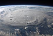
On August 11, a tropical wave moved off the west coast of Africa, and, encountering favorable conditions, quickly spawned Tropical Depression Four, roughly 520 miles (835 km) west-southwest of Cape Verde.[13] The depression was upgraded to Tropical Storm Dean on August 14 and became the first hurricane of the season just two days after. Dean reached a peak intensity as a Category 5 on the Saffir-Simpson Hurricane Scale—the strongest Atlantic hurricane since Hurricane Wilma—and it was tied for the seventh most intense Atlantic storm of all time. The hurricane made landfall on the Yucatán Peninsula on August 21, causing severe damage and at least 44 deaths.[14]
Tropical Storm Erin formed on August 16 in the Gulf of Mexico from a persistent area of convection. Erin moved northwestward, attaining peak winds of 40 mph (64 km/h), before making landfall on the Texas coast. Early on August 19 after entering Oklahoma, the remnants of Erin suddenly re-intensified to maximum sustained winds of 60 mph (95 km/h) a short distance west of Oklahoma City.[15] Although it was generally weak, Erin caused heavy flooding and 16 deaths.[16]
An area of disturbed weather east of the Windward Islands was designated Tropical Depression Six on August 31. Early on September 1, it was named Tropical Storm Felix, and it was upgraded to a hurricane later that day. Tracking generally westward, it rapidly intensified to Category 5, and after fluctuating in strength, made landfall on Nicaragua with 160 mph (260 km/h) winds. At least 133 deaths and more than $50 million (2007 USD) in damage have been attributed to Felix.[17] With Felix, the 2007 Atlantic hurricane season became the only one of its kind known to include two hurricanes making landfall at Category 5.[18]
September
Tropical Storm Gabrielle originated from a cold front that moved off the U.S. East Coast on September 7, initially existing as a subtropical storm. By the next day, however, the system gained tropical characteristics, and Gabrielle reached peak winds of 60 mph (97 km/h) just before making landfall on the coast of North Carolina and turning northeast into the open waters of the Atlantic Ocean.[19]
A large tropical wave emerged off the coast of Africa on September 6 and moved westward across the Atlantic. Gradually, the associated convection organized, and it was named Tropical Storm Ingrid on September 12. Ingrid remained weak, staying at moderate tropical storm intensity its for its entire life; it never affected land.[20]
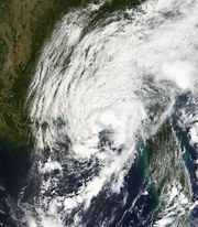
On September 12, an area of thunderstorm activity in the Gulf of Mexico organized into Tropical Depression Nine, about 60 mi (97 km) southeast of Matagorda, Texas. Within three hours of forming, it was named Tropical Storm Humberto, and it turned to the north-northeast before rapidly intensifying. A Hurricane Hunters aircraft found that Humberto had reached hurricane status while just 15 mph (24 km/h) offshore in the early hours of September 13 before making landfall at Category 1 strength.[21]
Tropical Depression Ten formed from the complex interaction between an upper-level low, a tropical wave that produced Tropical Storm Ingrid, and the tail end of a cold front. Initially classified as a subtropical depression, it attained tropical characteristics shortly before making landfall on the Florida Panhandle.[22]
On September 22, Subtropical Storm Jerry developed in the northern Atlantic. After about 48 hours it attained tropical characteristics, and it subsequently reached a peak intensity of 1,003 mbar. Jerry soon dissipated without affecting land.[23]
A large tropical wave associated with a large area of low pressure emerged off the coast of Africa on September 21. Tracking westward, it had developed sufficient convection to be designated as a tropical depression on September 24, and was upgraded to Tropical Storm Karen the next day. Though originally believed to have peaked at tropical storm status, post-season analysis revealed that it briefly attained Category 1 hurricane strength.[24]
A tropical wave emerged off the coast of Africa on September 11 and traversed the Atlantic, crossing the Yucatán Peninsula on September 21. On September 25 an associated low organized into a tropical depression in the southwest Gulf of Mexico. Further organization took place, and the depression was upgraded to Tropical Storm Lorenzo. Lorenzo peaked with winds of 80 mph (130 km/h)—a minimal hurricane—and made landfall near Tecolutla, Mexico.[25]
Tropical Storm Melissa formed on September 28 from a tropical wave that emerged into the Atlantic two days earlier. Certain factors prevented significant intensification, and Melissa failed to strengthen past a minimal tropical storm. Tracking northwestward, it dissipated on September 30.[26]
October–December
A surface low pressure system formed on the tail end of a large area of disturbed weather that stretched from the Caribbean Sea into the western Atlantic. While 645 nmi (1,195 km) southeast of Bermuda the system was sufficiently organized to be declared a tropical depression on October 11. Failing to intensify, it dissipated the next day.[27]
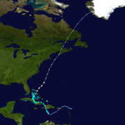
During the evening of October 27 a low pressure system that had been slowly developing over the eastern Caribbean organization into Tropical Depression Sixteen. The next day, it was upgraded to Tropical Storm Noel and made landfall on Haiti on October 29. Noel meandered across the western Caribbean for the next three days; the storm intensified into a hurricane on November 1. Tracking northward, it began its transition into an extratropical cyclone on November 2, becoming fully extratropical on November 4 while over Labrador. As a powerful extratropical cyclone, it crossed back into the Atlantic and began a track towards western Greenland.[28]
In the second week of December, after the official end of the hurricane season, a low developed east of the northernmost Lesser Antilles. On December 10 it was designated as Subtropical Storm Olga while north of Puerto Rico. The storm made landfall on December 11 on the eastern tip of the Dominican Republic and attained tropical characteristics while over land. By December 13, Olga had dissipated, having killed an estimated 40 people.[29]
Impact
The 2007 season was severe in terms of damage, mostly in the Caribbean. Collectively, storms caused more than 423 fatalities and about $3 billion (2007 USD) in damage.
In Hispaniola, Hurricane Dean killed 15 people and destroyed hundreds of homes.[30][31] Dean also left $616 million (2007 USD) in damage on Martinique and $154 million (2007 USD) on Guadeloupe.[32] Hurricane Felix took a similar path, although its effects were not severe; damage on Tobago was estimated at $250,000 (2007 TTD, $40,000 2007 USD).[33] Hurricane Noel caused severe damage throughout the region. Torrential rainfall and mudslides caused by the storm killed at least 87 people in the Dominican Republic and at least 73 in Haiti.[28] In addition, Tropical Storm Olga triggered flooding in the Dominican Republic, killing at least 37 people.[34][35]
Hurricane Felix made landfall just south of the border between Nicaragua and Honduras, in a region historically known as the Mosquito Coast, as a Category 5 hurricane with 160 mph (260 km/h) winds on September 4.[18] Residents of the region were reported to have been given little warning of the oncoming hurricane, which left many fisherman stranded at sea.[36] In all, Felix killed at least 130 people,[18] and damage in Nicaragua totaled C$869.3 million (2007 NIO, $46.7 million 2007 USD).[17] In Mexico, Hurricane Dean made landfall on the Yucatán Peninsula on August 21 as a Category 5 hurricane.[37] Throughout its track, Dean killed 44 people[38] and caused several billion dollars in damage.[14][39][40][41][42] Hurricane Lorenzo struck central Mexico to the south-southwest of Tuxpan as a Category 1 hurricane, causing an estimated $1 billion (2007 MXN, $92 million 2007 USD) in damage.[43] Lorenzo caused six deaths in Tuxpan and destroyed 169 houses in Puebla.[25]
During the season, five Atlantic storms affected the United States. However, these storms were relatively weak; three tropical depressions and one tropical storm and hurricane made landfall in the country, with their names being Gabrielle and Humberto. Subtropical Storm Andrea meandered off the Southeastern coast, producing 34 feet (10 m) waves on the coast of South Carolina.[44][45] Almost a month later, Tropical Storm Barry struck the state of Florida. The rainfall resulted in slick roads, which caused two traffic-related deaths, and a woman was killed after being injured by rough surf.[10][11] Tropical Storm Erin made landfall in Texas, flooding more than 40 homes and businesses. Along its path into the central states, Erin killed 16 people—9 directly—and left about $25 million (2007 USD) in total damage.[16] In the second week of September, Tropical Storm Gabrielle moved ashore on North Carolina, causing moderate wind gusts and light rainfall, although minimal damage.[19] Shortly thereafter, Hurricane Humberto made landfall on High Island, Texas, with winds of about 90 mph (150 km/h). $50 million (2007 USD) in damages were reported.[21] An unnamed tropical depression struck the coast of the Florida Panhandle about one week after Humberto dissipated. It caused no known deaths or serious injuries and just $6.2 million in damage (USD).[22]
Three tropical cyclones directly affected Canada, although the first, Tropical Storm Barry, caused no reported effects.[9] The next storm, Tropical Storm Chantal, moved over the Avalon Peninsula of Newfoundland where flooding was observed.[12] Insured damage across the area totaled $5.8 million (2007 CAD, $5.5 million 2007 USD).[46] The most notable storm was Hurricane Noel, which generated winds of 130 mph (210 km/h) in the Wreckhouse region of Newfoundland and Labrador.[47]
Accumulated Cyclone Energy (ACE) rating
| 1 | 35.23 | Dean | 8 | 1.10 | Gabrielle |
|---|---|---|---|---|---|
| 2 | 18.03 | Felix | 9 | 0.78 | Olga |
| 3 | 5.62 | Noel | 10 | 0.77 | Barry |
| 4 | 3.62 | Karen | 11 | 0.73 | Chantal |
| 5 | 1.81 | Humberto | 12 | 0.49 | Melissa |
| 6 | 1.48 | Lorenzo | 13 | 0.37 | Erin |
| 7 | 1.30 | Ingrid | 14 | 0.37 | Jerry |
| Total: 71.7 | |||||
The table on the right shows the Accumulated Cyclone Energy (ACE) for each storm in the season. ACE is, broadly speaking, a measure of the power of the hurricane multiplied by the length of time it existed, so storms that last a long time, as well as particularly strong hurricanes, have high ACEs. ACE is only calculated for full advisories on tropical systems at or exceeding 34 knots (39 mph, 63 km/h) or tropical storm strength. The highest ever ACE estimated for a single storm in the Atlantic is 73.6, for Hurricane San Ciriaco in 1899. This single storm had an ACE higher than many whole Atlantic storm seasons, like this one. Other Atlantic storms with high ACEs include Hurricane Ivan in 2004, with an ACE of 70.4, Hurricane Donna in 1960, with an ACE of 64.6, and Hurricane Isabel of the 2003 Atlantic hurricane season had an ACE of 63.28
While Subtropical Storm Andrea was a named storm of the 2007 season, NOAA does not officially include subtropical storms' ACE ratings in season totals.[48] Andrea's ACE would have been 0.895 104kt² had it been tropical. Values accrued while Gabrielle, Jerry and Olga were subtropical are not included in their totals. The strongest storm was Hurricane Dean with a total ACE of 35.56, while Hurricane Felix came in second at 18.03. Dean's ACE was almost twice as high because it lasted about twice as long as Felix. With an ACE of 0.37, Tropical Storm Jerry and Tropical Storm Erin were tied for the lowest during the season.
Records and statistics
Only two major hurricanes—storms of Category 3 intensity or higher—formed during the season, the least since the 1997 season, although tied with the 2006 and 2002 seasons. Named storms were active for 33.50 days during the season, the lowest since 1994. There were 11.25 days with active hurricanes, the lowest value since 2002. Despite this, the number of days with major hurricanes was above average. Four named storms made landfall on the U.S. during the year, but damage totaled only about $82 million; this was the least damage the U.S. saw from any Atlantic hurricane season since 1990.[38] The season was one of four that produced two Category 5 hurricanes. Dean and Felix reached Category 5 strength twice, the first time two Atlantic hurricanes have done so in a single season. This was also the first season during which two storms made landfall at Category 5 intensity. Also, when Hurricane Felix was upgraded to a Category 5 storm on September 2, it was the eighth Category 5 storm to form in this basin since 2000. This gave the decade more hurricanes of such strength than any other on record.[49]
Hurricane Dean was the first storm to make landfall as a Category 5 hurricane in the Atlantic basin since Hurricane Andrew in 1992. A dropsonde in the eye of the storm estimated a central pressure of 905 mbar, tying Dean with Camille and Mitch for the seventh most intense Atlantic hurricane ever recorded. Dean was the third most intense landfalling Atlantic storm in history (after the Labor Day Hurricane of 1935 and Hurricane Gilbert of 1988).[14] When Tropical Depression Fourteen was upgraded to Tropical Storm Melissa on September 29, it was the eighth named storm to form in the month of September. That tied a record for the most storms during September, which was first set in 2002.[50] Hurricane Humberto was the first hurricane to make landfall in Texas since Hurricane Claudette in 2003.[38]
Storm names
|
|
|
The names to the right were used for storms that formed in the Atlantic basin in 2007.[51] This is the same list used in the 2001 season except for Andrea, Ingrid, and Melissa, which replaced Allison, Iris, and Michelle, respectively and were first used in 2007. Names that were not assigned are marked in gray.
Retirement
On May 13, 2008, at the 30th Session of the World Meteorological Organization's Regional Association IV Hurricane Committee, the WMO retired the names Dean, Felix, and Noel from its rotating name lists. The names were replaced with Dorian, Fernand, and Nestor.[52]
Season impact
| Saffir–Simpson Hurricane Scale | |||||||
| TD | SS | TS | C1 | C2 | C3 | C4 | C5 |
| Storm Name |
Dates active | Storm category
at peak intensity |
Max Wind (mph) |
Min. Press. (mbar) |
Landfall(s) | Damage (millions USD) |
Deaths | |||
|---|---|---|---|---|---|---|---|---|---|---|
| Where | When | Wind
(mph) |
||||||||
| Andrea | May 9 – May 11 | Subtropical Storm | 60 | 1001 | none | minimal | 0 (6) | |||
| Barry | June 1 – June 2 | Tropical Storm | 60 | 997 | Tampa Bay, Florida | June 2 | 35 | minimal | 1 (2) | |
| Chantal | July 31 – August 1 | Tropical Storm | 50 | 997 | none | >5.5 | 0 | |||
| Dean | August 13 – August 23 | Category 5 Hurricane | 175 | 905 | Costa Maya, Mexico | August 21 | 175 | 1,500 | 32 (12) | |
| Tecolutla, Veracruz | August 22 | 100 | ||||||||
| Erin | August 14 – August 17 | Tropical Storm | 40 | 1003 | San José Island, Texas | August 16 | 35 | 25 | 16 | |
| Felix | August 31 – September 6 | Category 5 Hurricane | 175 | 929 | Grenada | September 1 | 50 | 50.38 | 130 (3) | |
| Punta Gorda, Nicaragua | September 5 | 160 | ||||||||
| Gabrielle | September 8 – September 11 | Tropical Storm | 60 | 1004 | Cape Lookout, NC | September 9 | 60 | minimal | none | |
| Ingrid | September 12 – September 17 | Tropical Storm | 45 | 1002 | none | none | none | |||
| Humberto | September 12 – September 14 | Category 1 Hurricane | 90 | 985 | High Island, TX | September 13 | 90 | 50 | 1 | |
| Ten | September 21 – September 22 | Tropical Depression | 35 | 1005 | Fort Walton Beach, FL | September 21 | 30 | 6.2 | none | |
| Jerry | September 23 – September 24 | Tropical Storm | 40 | 1003 | none | none | none | |||
| Karen | September 25 – September 29 | Category 1 Hurricane | 75 | 988 | none | none | none | |||
| Lorenzo | September 25 – September 28 | Category 1 Hurricane | 80 | 990 | Tecolutla, Veracruz | September 28 | 75 | 92 | 6 | |
| Melissa | September 28 – September 30 | Tropical Storm | 40 | 1005 | none | none | none | |||
| Fifteen | October 11 – October 12 | Tropical Depression | 35 | 1011 | none | none | none | |||
| Noel | October 28 – November 2 | Category 1 Hurricane | 80 | 980 | Jacmel, Haiti | October 29 | 50 | 582 | 163 (6) | |
| Guardalavaca, Cuba | October 30 | 60 | ||||||||
| Andros, Bahamas | November 1 | 60 | ||||||||
| Nassau, Bahamas | November 1 | 65 | ||||||||
| Olga | December 11 – December 13 | Tropical Storm | 60 | 1003 | Vega Baja, Puerto Rico | December 11 | 45 | 45 | 45 | |
| Punta Cana, Dominican Republic | December 11 | 60 | ||||||||
| Season Aggregates | ||||||||||
| 17 cyclones | May 9 – December 13 | 175 | 905 | 16 landfalls | ~3,000 | 394 (29) | ||||
See also
- List of Atlantic hurricanes
- List of Atlantic hurricane seasons
- 2007 Pacific hurricane season
- 2007 Pacific typhoon season
- 2007 North Indian Ocean cyclone season
- South-West Indian Ocean cyclone seasons: 2006–07, 2007–08
- Australian region cyclone seasons: 2006–07, 2007–08
- South Pacific cyclone seasons: 2006–07, 2007–08
Notes
- ↑ The cumulative damage figures were obtained by summing the damage figures on the individual Tropical Cyclone Reports referenced throughout the article, with the exception of Hurricane Dean. Dean's damage figures were obtained by adding the per-country totals referenced in the Impact section of this article.
References
- ↑ 1.0 1.1 1.2 1.3 Philip J. Klotzbach and William M. Gray (2006-12-08). "Extended Range Forecast of Atlantic Seasonal Hurricane Activity and U.S. Landfall Strike Probability for 2007". Colorado State University. http://hurricane.atmos.colostate.edu/forecasts/2006/dec2006/. Retrieved 2006-12-08.
- ↑ 2.0 2.1 Climate Prediction Center (2006-08-08). "Background Information: The North Atlantic Hurricane Season". National Oceanic and Atmospheric Administration. http://www.cpc.noaa.gov/products/outlooks/background_information.shtml#NOAADEF. Retrieved 2006-12-08.
- ↑ 3.0 3.1 "Colorado State forecast team calls for very active 2007 hurricane season". Colorado State University. 2007-04-03. Archived from the original on 2010-04-14. http://www.webcitation.org/5ozg9L8dq. Retrieved 2007-04-03.
- ↑ 4.0 4.1 Philip J. Klotzbach and William M. Gray (2007-04-03). "Extended Range Forecast of Atlantic Seasonal Hurricane Activity and U.S. Landfall Strike Probability for 2007". Colorado State University. http://hurricane.atmos.colostate.edu/Forecasts/2007/april2007/. Retrieved 2007-04-03.
- ↑ "UKMO North Atlantic tropical storms seasonal forecast for 2007". http://www.metoffice.gov.uk/weather/tropicalcyclone/northatlantic_2007.html.
- ↑ Philip J. Klotzbach and William M. Gray (2007-08-03). "Extended Range Forecast of Atlantic Seasonal Hurricane Activity and U.S. Landfall Strike Probability for 2007" (PDF). Colorado State University. http://typhoon.atmos.colostate.edu/Forecasts/2007/aug2007/aug2007.pdf. Retrieved 2007-08-03.
- ↑ NOAA (2007-08-09). "NOAA updates Atlantic hurricane season outlook". National Oceanic and Atmospheric Administration. http://www.noaanews.noaa.gov/stories2007/s2905.htm. Retrieved 2007-08-09.
- ↑ Jamie R. Rhome, Jack Beven, and Mark Willis (2007). "Tropical Cyclone Report: Subtropical Storm Andrea" (PDF). National Hurricane Center. http://www.nhc.noaa.gov/pdf/TCR-AL012007_Andrea.pdf. Retrieved 2008-05-13.
- ↑ 9.0 9.1 Lixion Avila (2007). "Tropical Storm Barry Tropical Cyclone Report" (PDF). National Hurricane Center. http://www.nhc.noaa.gov/pdf/TCR-AL022007_Barry.pdf. Retrieved 2007-06-22.
- ↑ 10.0 10.1 WFTV-9 (2007). "Barry Downgraded After Soaking Central Florida". http://www.wftv.com/news/13428614/detail.html. Retrieved 2007-06-03.
- ↑ 11.0 11.1 McMichael (2007). "Tropical Storm Barry Post Tropical Cyclone Report". Ruskin, Florida National Weather Service. http://www.srh.noaa.gov/data/warn_archive/TBW/PSH/0609_100716.txt. Retrieved 2007-06-11.
- ↑ 12.0 12.1 Richard Pasch (2007). "Tropical Storm Chantal Tropical Cyclone Report" (PDF). National Hurricane Center. http://www.nhc.noaa.gov/pdf/TCR-AL032007_Chantal.pdf. Retrieved 2007-10-18.
- ↑ Knabb/Blake (2007). "August 13 Tropical Weather Outlook (1130)". National Hurricane Center. ftp://ftp.met.fsu.edu/pub/weather/tropical/Outlook-A/2007081315.ABNT20. Retrieved 2007-08-14.
- ↑ 14.0 14.1 14.2 James L. Franklin (2007). "Tropical Cyclone Report: Hurricane Dean" (PDF). National Hurricane Center. http://www.nhc.noaa.gov/pdf/TCR-AL042007_Dean.pdf. Retrieved 2008-05-14.
- ↑ David M. Roth (2007). "Tropical Storm Erin Rainfall". Hydrometeorological Prediction Center. http://www.hpc.ncep.noaa.gov/tropical/rain/erin2007.html. Retrieved 2007-08-24.
- ↑ 16.0 16.1 Richard D. Knabb (2008). "Tropical Cyclone Report: Tropical Storm Erin" (PDF). National Hurricane Center. http://www.nhc.noaa.gov/pdf/TCR-AL052007_Erin.pdf. Retrieved 2008-05-14.
- ↑ 17.0 17.1 Organización de las Naciones Unidas para la Agricultura y la Alimentación (FAO), Nicaragua (2007). "Evaluación de Daños Causados por el Huracán Félix en el Caribe de Nicaragua." (in Spanish) (PDF). http://www.fao.org/fileadmin/templates/tc/tce/pdf/Nicaragua_FAO_Evaluacion_2007.pdf. Retrieved 2008-03-24.
- ↑ 18.0 18.1 18.2 Jack Beven (2008-01-16). "Tropical Cyclone Report: Hurricane Felix" (PDF). National Hurricane Center. http://www.nhc.noaa.gov/pdf/TCR-AL062007_Felix.pdf. Retrieved 2008-02-22.
- ↑ 19.0 19.1 Daniel Brown (2007). "Tropical Storm Gabrielle Tropical Cyclone Report" (PDF). National Hurricane Center. http://www.nhc.noaa.gov/pdf/TCR-AL072007_Gabrielle.pdf. Retrieved 2007-10-30.
- ↑ National Hurricane Center (2007). "Tropical Cyclone Report for Tropical Storm Ingrid" (PDF). http://www.nhc.noaa.gov/pdf/TCR-AL082007_Ingrid.pdf. Retrieved 2007-11-09.
- ↑ 21.0 21.1 Blake (2007). "Hurricane Humberto Tropical Cyclone Report" (PDF). National Hurricane Center. http://www.nhc.noaa.gov/pdf/TCR-AL092007_Humberto.pdf. Retrieved 2007-11-19.
- ↑ 22.0 22.1 Jamie R. Rhome (2007-10-15). "Tropical Cyclone Report: Tropical Depression Ten" (PDF). National Hurricane Center. http://www.nhc.noaa.gov/pdf/TCR-AL102007_Ten.pdf. Retrieved 2008-02-22.
- ↑ Lixion A. Avila (2007-10-24). "Tropical Cyclone Report: Tropical Storm Jerry" (PDF). National Hurricane Center. http://www.nhc.noaa.gov/pdf/TCR-AL112007_Jerry.pdf. Retrieved 2008-02-22.
- ↑ Richard J. Pasch (2007-11-27). "Tropical Cyclone Report: Hurricane Karen" (PDF). National Hurricane Center. http://www.nhc.noaa.gov/pdf/TCR-AL122007_Karen.pdf. Retrieved 2008-02-22.
- ↑ 25.0 25.1 James L. Franklin (2007-10-18). "Tropical Cyclone Report: Hurricane Lorenzo" (PDF). National Hurricane Center. http://www.nhc.noaa.gov/pdf/TCR-AL132007_Lorenzo.pdf. Retrieved 2008-02-22.
- ↑ Richard D. Knabb (2007-10-13). "Tropical Cyclone Report: Tropical Storm Melissa" (PDF). National Hurricane Center. http://www.nhc.noaa.gov/pdf/TCR-AL142007_Melissa.pdf. Retrieved 2008-02-22.
- ↑ Jack Beven (2007-11-22). "Tropical Cyclone Report: Tropical Depression Fifteen" (PDF). National Hurricane Center. http://www.nhc.noaa.gov/pdf/TCR-AL152007_Fifteen.pdf. Retrieved 2008-02-22.
- ↑ 28.0 28.1 Daniel P. Brown (2007-12-17). "Tropical Cyclone Report: Hurricane Noel" (PDF). National Hurricane Center. http://www.nhc.noaa.gov/pdf/TCR-AL162007_Noel.pdf. Retrieved 2008-02-22.
- ↑ Michelle Mainelli (2008-01-24). "Tropical Cyclone Report: Tropical Storm Olga" (PDF). National Hurricane Center. http://www.nhc.noaa.gov/pdf/TCR-AL172007_Olga.pdf. Retrieved 2008-02-22.
- ↑ United Nations Office for the Coordination of Humanitarian Affairs (OCHA) (2007-08-19). "Hurricane Dean OCHA Situation Report No. 3". Relief Web. http://www.reliefweb.int/rw/rwb.nsf/db900sid/EKOI-769457?OpenDocument&rc=2&emid=TC-2007-000135-LCA. Retrieved 2007-08-25.
- ↑ Staff Writer (2007-08-19). "Monster hurricane bears down on Jamaica". Agence France-Presse.
- ↑ Meteo-France (2008). "Summary of the 2007 Hurricane Season in the French West Indies" (DOC). World Meteorological Organization. http://www.wmo.int/pages/prog/www/tcp/Meetings/HC30/documents/Doc.4Add.1.E.doc. Retrieved 2008-06-05.
- ↑ Jensen LaVende (2007-09-02). "Cars, shop swept away at Carenage". Trinidad & Tobago Express. http://www.trinidadexpress.com/index.pl/article_news?id=161197574. Retrieved 2007-09-02.
- ↑ "40 dead in Caribbean tropical storm". Agence France-Press/News.com.au. 2007-12-15.
- ↑ Associated Press (2007-12-15). "Dominican officials say Tropical Storm Olga causes major crop losses".
- ↑ James Orr (2007-09-07). "Hundreds still missing as Felix toll reaches 98". The Guardian (London). http://www.guardian.co.uk/world/2007/sep/07/weather. Retrieved 2008-05-17.
- ↑ AFP (2007). "Hurricane Dean turns deadly". France 24. http://www.france24.com/france24Public/en/news/world/20070819-dean-hurricane-jamaica-yucatan-catergory-four.html. Retrieved 2007-08-19.
- ↑ 38.0 38.1 38.2 Philip J. Klotzbach and William M. Gray (2007). "Summary Of 2007 Atlantic Tropical Cyclone Activity And Verification
Of Author’s Seasonal And Monthly Forecasts" (PDF). Colorado State University. http://hurricane.atmos.colostate.edu/Forecasts/2007/nov2007/nov2007.pdf. Retrieved 2008-06-05. - ↑ Staff Writer (2008-07-04). "ODPEM pleads for grants". Jamaica Gleaner. http://www.jamaica-gleaner.com/gleaner/20080704/lead/lead4.html. Retrieved 2008-07-24.
- ↑ Reuters (2007-08-30). "Dean caused 500 m euro damage in French Caribbean". http://www.caribbeannetnews.com/martinique/martinique.php?news_id=3302&start=0&category_id=34. Retrieved 2008-03-24.
- ↑ International Monetary Fund (2008-02-08). "Dominica's recovery efforts boosted by US$3.3m in IMF emergency assistance". http://www.caribbeannetnews.com/index.php?news_id=5918. Retrieved 2008-03-24.
- ↑ EQECAT (2007-08-20). "EQECAT Estimates Dean Losses Between $1.5-$ 3 Billion". http://www.insurancejournal.com/news/international/2007/08/20/82848.htm. Retrieved 2007-08-20.
- ↑ Lev García (2007). "'Lorenzo' deja daños por mil millones de pesos en Veracruz" (in Spanish). El Mañana.
- ↑ "High drama on high seas". Virginia Pilot. 2007-05-08.
- ↑ "Wind and chill chase away spring today's weather". Virginia Pilot. 2007-05-07.
- ↑ Canadian Underwriter (2007). "What's New: In Brief". http://www.canadianunderwriter.ca/issues/story.aspx?aid=1000069051&issue=09122007. Retrieved 2007-09-14.
- ↑ "Thousands still without power in Noel's wake". CTV. November 4, 2007. http://www.ctv.ca/servlet/ArticleNews/story/CTVNews/20071103/hurricane_Noel_071104/20071104?hub=TopStories. Retrieved 2007-11-10.
- ↑ "2007 Atlantic Ocean Tropical Cyclones". National Oceanic and Atmospheric Administration. 2007-06-01. http://lwf.ncdc.noaa.gov/oa/climate/research/2007/2007-atlantic-trop-cyclones.html. Retrieved 2007-06-03.
- ↑ Staff Writer (2010-03-01). "Atlantic hurricane best track (Hurdat)". National Hurricane Center. National Oceanic and Atmospheric Administration. http://www.nhc.noaa.gov/tracks1851to2009_atl_reanal.txt. Retrieved 2010-03-20.
- ↑ Forecasters Mainelli; Avila; Brown; Blake; Rhome; Knabb; Franklin; Pasch (2007-10-01). "Tropical Weather Summary – September 2007". National Hurricane Center. http://www.nhc.noaa.gov/archive/2007/tws/MIATWSAT_sep.shtml?. Retrieved 2007-11-12.
- ↑ National Hurricane Center (2008). "Worldwide Tropical Cyclone Names". National Oceanic and Atmospheric Administration. http://www.nhc.noaa.gov/aboutnames.shtml. Retrieved 2008-05-14.
- ↑ "Dean, Felix and Noel "Retired" from List of Storm Names". National Oceanic and Atmospheric Administration. May 13, 2008. http://www.noaanews.noaa.gov/stories2008/20080513_stormnames.html. Retrieved May 13, 2008.
External links
- National Hurricane Center Website
- 2007 hurricanes – Free download of all 2007 hurricane paths – GoogleTM Earth required
|
|
|||||||||||||||||||||||||||||||||
|
|||||