Chita, Zabaykalsky Krai
| Chita (English) Чита (Russian) |
|
|---|---|
| — Inhabited locality — | |
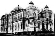
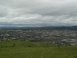 View of Chita from Titovskaya Sopka |
|
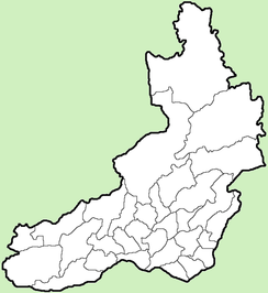
.svg.png) Location of Zabaykalsky Krai in Russia |
|
 Chita
|
|
| Coordinates: | |
.png) |
|
| Administrative status | |
| Country | Russia |
| Federal subject | Zabaykalsky Krai |
| Administrative center of | Zabaykalsky Krai |
| Municipal status | |
| Urban okrug | Chita Urban Okrug |
| Mayor | Anatoly Mikhalyov |
| Statistics | |
| Area | 538 km2 (208 sq mi) |
| Population (2002 Census) | 316,643 inhabitants[1] |
| - Density | 589 /km2 (1,530 /sq mi)[2] |
| Time zone | YAKT/YAKST (UTC+9/+10) |
| Founded | 1653 |
| Postal code(s) | 672000–672051 |
| Dialing code(s) | +7 3022 |
| Official website | |
Chita (Russian: Чита́) is a city and the administrative center of Zabaykalsky Krai, Russia It stands at the confluence of the Chitinka and Ingoda Rivers and on the Trans-Siberian Railway, c. 900 kilometers (559 mi) east of Irkutsk. Chita's population was estimated at 308,500 in 2001. According to the 2002 Census its population was 316,643.[1]
The city is the headquarters of the Siberian Military District. It is served by Chita Kadala Airport and the Chita Northwest air base.
Contents |
History
Before 1825
The region was originally inhabited by local Mongolic and Turkic tribes, along with various Chinese traders for several centuries before the Russians arrived there. The settlement of Chita is known since 1653 founded by Pyotr Beketov's Cossacks, but it had been overshadowed by Nerchinsk until the 20th century. Chita was incorporated as a town in 1851. By 1885 the population had reached 5,728, increasing to 11,480 in 1897.
1825 to 1918
After 1825 several of the Decembrists suffered exile to Chita and thus, Chita is on occasion called the “City of Exiles”. Many of the Decembrists were intellectuals and members of the middle class, and consequently their arrival had a positive effect. The well-educated exiles made an effort to educate the citizens of Chita and pursue trade. Through these efforts, the city became a major trading portal in Siberia, particularly since the natural resources of the area included timber, gold and uranium.

At the end of the 19th century many Muslims settled in Chita, attracted by its trading potential. These Muslims were mainly of Tatar origin. They settled down near the Jewish quarter and built a mosque. Many Tatars resident in Chita today are their descendants.
Perhaps due in part to the influence of the early revolutionary exiles, Chita was a centre for worker unrest in the early years of the 20th century. After Father Gapon and his workers were massacred in St. Petersburg in January 1905, Chita became a centre for worker demonstrations, which led to armed revolutionaries taking control of the city and declaring the "Chita Republic". Troops sent by the Tsar quickly crushed the new government and its leaders were severely punished on the slope of Titovskaya Hill.
1918 to 1945
Chita was occupied by the Japanese between 1918 and 1920. From 1920 to 1922 Chita served as the capital of the Far Eastern Republic. From the 1930s to the end of communism, Chita was a closed city. During this period, foreigners were prohibited from travelling to Chita as were many Russians. The basis for the closing of the city was apparently its proximity to China and military installations. During World War II, a significant number of Japanese soldiers were taken by the Russians as prisoners of war. Through whatever machinations present at that time, they were put to work in the construction industry. In the centre of Chita you will find buildings with a definite hint of Japanese style. The buildings are not overtly Japanese, but they definitely differ from the other styles present.
Post-1945
In 1945, Pu Yi, the last Emperor of China, and some of his associates were held prisoner in the city, in a former sanatorium for officers.[3]. Chita was a 'closed city' and foreigners were kept out until 1991.
Jews in Chita and its region
The first Jews migrated to the Chita region in the second half of the 19th century due to building of silver plants and mines in Transbaikal, and its closeness to the Russian border with China which helped the newly built townlets enjoy an international trade. There were four allowed ranks of Jewish immigrants in Transbaikal, divided into top traders, specialists or craftsmen; soldiers (former cantonists and their families); and political exiles. As a result, most of the Jewish population which moved to Chita and other townlets were male. It led to the establishment of shadchanut, the institution of Jewish matching, allowing the conversion of local non-Jewish women.
In 1836, the Russian Tsar, Nicholas I allowed Jews of the Pale of Settlement to sink roots in Siberia and become, unusually in Jewish history, farmers. After a few years, the local authorities tried to prevent further Jewish penetration into the region.
According to the first census of 1897, the Jewish population in the Transbaikal region was about 8,000 people, and more than 1,200 of them lived in Chita. Chita was home to Jewish political Zionism and Socialist parties during the first decades of the 20th century. Yemelyan Yaroslavsky (Gubelman), one of the Bolshevik leaders, was born in Chita.
When the Russian Revolution occurred, most of Jews of Chita were supporters of the White movement, despite its antisemitism. By 1919 ataman Semyonov formed the Jewish regiment that took part in many anti-Bolshevik operations. During the time of the Far East Republic, Jewish life in the Republic was able to continue without any of the obstacles faced in the rest of the Soviet Union. During this time the Jews played a significant role in the economic development of the region. After the Communists came to power in 1923, most of the Jews of Chita left the city for Chinese cities especially for Harbin, China.
By 1929 the Jewish community had been outlawed and the largest synagogue in Asia was nationalised; it was only in 2004 that it was returned to a tiny Jewish community. Most of the small Jewish population of some one thousand people have emigrated to Israel since 1989. About two hundred Jews currently live in the city. These Jews originated from different parts of the former Soviet Union. The percentage of intermarriages is high because of lack of a real Jewish life and high assimilation.
Architecture
Chita is laid out in a grid pattern, which is rare in Russia. Architecturally, Chita is a clash of styles. Foremost, Chita is populated with five-storey communist concrete buildings. In contrast to these Soviet signatures, Chita is also populated with individual homes made primarily out of wood, the equivalent of those you would see in any mountainous area.
Education
Chita is home to several higher education places:
- Chita State University
- Chita State Academy of Medicine
- Chita State University of Polytechnics
Sports
- FC Chita
Universitet Chita compete in the Professional Rugby League, the top division of rugby union in Russia.
SKA Zabaykalets has played in the highest division of the Russian Bandy League.[4]
Climate
Chita experiences a subarctic climate (Köppen climate classification Dwc) with very cold, very dry winters and very warm, wet summers.
| Climate data for Chita | |||||||||||||
|---|---|---|---|---|---|---|---|---|---|---|---|---|---|
| Month | Jan | Feb | Mar | Apr | May | Jun | Jul | Aug | Sep | Oct | Nov | Dec | Year |
| Record high °C (°F) | 0.4 (32.7) |
7.5 (45.5) |
18.3 (64.9) |
26.9 (80.4) |
36.9 (98.4) |
43.2 (109.8) |
43.0 (109.4) |
40.9 (105.6) |
35.0 (95) |
26.0 (78.8) |
12.7 (54.9) |
3.3 (37.9) |
43.2 (109.8) |
| Average high °C (°F) | -18.4 (-1.1) |
-12.1 (10.2) |
-1.9 (28.6) |
8.2 (46.8) |
17.0 (62.6) |
24.1 (75.4) |
25.7 (78.3) |
22.8 (73) |
16.1 (61) |
6.7 (44.1) |
-6.8 (19.8) |
-16.5 (2.3) |
5.6 (42.1) |
| Average low °C (°F) | -32.5 (-26.5) |
-29.2 (-20.6) |
-19.2 (-2.6) |
-7.0 (19.4) |
0.4 (32.7) |
7.6 (45.7) |
11.7 (53.1) |
9.3 (48.7) |
1.8 (35.2) |
-7.1 (19.2) |
-19.8 (-3.6) |
-29.0 (-20.2) |
-9.3 (15.3) |
| Record low °C (°F) | -49.6 (-57.3) |
-48.0 (-54.4) |
-45.3 (-49.5) |
-29.6 (-21.3) |
-13.3 (8.1) |
-5.4 (22.3) |
0.1 (32.2) |
-9.2 (15.4) |
-10.7 (12.7) |
-33.1 (-27.6) |
-41.1 (-42) |
-47.8 (-54) |
-49.6 (-57.3) |
| Precipitation mm (inches) | 2 (0.08) |
3 (0.12) |
3 (0.12) |
9 (0.35) |
23 (0.91) |
58 (2.28) |
102 (4.02) |
80 (3.15) |
38 (1.5) |
10 (0.39) |
6 (0.24) |
4 (0.16) |
338 (13.31) |
| Source: Pogoda.ru.net[5] | |||||||||||||
Twin towns — sister cities
Chita is twinned with:
References
- ↑ 1.0 1.1 Федеральная служба государственной статистики (Federal State Statistics Service) (2004-05-21). "Численность населения России, субъектов Российской Федерации в составе федеральных округов, районов, городских поселений, сельских населённых пунктов – районных центров и сельских населённых пунктов с населением 3 тысячи и более человек (Population of Russia, its federal districts, federal subjects, districts, urban localities, rural localities—administrative centers, and rural localities with population of over 3,000)" (in Russian). Всероссийская перепись населения 2002 года (All-Russia Population Census of 2002). Federal State Statistics Service. http://perepis2002.ru/ct/html/TOM_01_04_1.htm. Retrieved 2009-08-19.
- ↑ The value of density was calculated automatically by dividing the 2002 Census population by the area specified in the infobox. Please note that this value may not be accurate as the area specified in the infobox does not necessarily correspond to the area of the entity proper or is reported for the same year as the Census (2002).
- ↑ S. I. Kuznetsov and S. V. Karasov, "The Last Emperor of China: Internment in the Soviet Union", The Journal of Slavic Military Studies 18(2), 207-226 (2005). DOI: 10.1080/13518040590944430
- ↑ Video from the stadium: http://rutube.ru/tracks/108949.html?v=9a2886ed73120cac4a628daa3c889231
- ↑ "Pogoda.ru.net" (in Russian). http://pogoda.ru.net/climate/30758.htm. Retrieved September 8, 2007.
- Materials on Jewish life were taken from the Chita Oblast State Archives but most accountable and reliable ones are still in the local KGB Archives.
 This article incorporates text from a publication now in the public domain: Chisholm, Hugh, ed (1911). Encyclopædia Britannica (Eleventh ed.). Cambridge University Press.
External links
|
||||||||