Chur
| Chur | ||||||||||
|---|---|---|---|---|---|---|---|---|---|---|
 |
||||||||||
|
||||||||||
| Population | 33,377 (Dec 2009)[1] | |||||||||
| - Density | 1,192 /km2 (3,086 /sq mi) | |||||||||
| Area | 28.01 km2 (10.81 sq mi) | |||||||||
| Elevation | 593 m (1,946 ft) | |||||||||
| - Highest | 1885 m - Fürhörnli | |||||||||
| - Lowest | 554 m - Bettlerküche | |||||||||
| Postal code | 7000-7007 | |||||||||
| SFOS number | 3901 | |||||||||
| Mayor (list) | Christian Boner (as of 2008) SVP/UDC | |||||||||
| Localities | Altstadt, Sand, Kasernenquartier, Industriegebiet, Loestrasse-Lürlibad, Masans, Rheinquartier | |||||||||
| Surrounded by | Churwalden, Domat/Ems, Felsberg, Haldenstein, Maladers, Malix, Trimmis | |||||||||
| Twin towns | Bad Homburg (Germany), Cabourg (France), Mayrhofen (Austria), Mondorf-les-Bains (Luxembourg), Olathe (USA), Terracina (Italy) | |||||||||
| Website | www.chur.ch SFSO statistics |
|||||||||
 Chur
|
||||||||||
| View map of Chur | ||||||||||

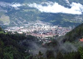
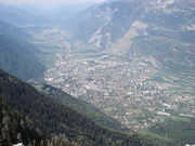
Chur (German: Chur pronounced [ˈkuːr] (in Graubünden), [ˈxuːʁ] (elsewhere); Alemannic German: Khûr; Romansh: Cuira IPA: [ˈkwera] or [ˈkwojra]; Italian: Coira [ˈkɔjra]); French: Coire; Latin: Curia, Curia Rhaetorum and Curia Raetorum) is the capital of the Swiss canton of Graubünden and lies in the northern part of the canton.
Contents |
History
The city of Chur is the seat of the bishops of Chur and capital of the Swiss canton of Graubünden, in which Chur is the most populous municipality. Archaeological evidence of settlement at the site goes back as far as the Pfyn culture[2] (3900-3500 BC)[3], making Chur one of the oldest settlements in Switzerland. The city is located at a highly strategic location, where the roads from several major Alpine transit routes come together and continue down the Rhine river.
The modern name Chur derives from when the site was a Roman fortified camp, Curia Raetorum in Latin. Later in the Roman period, Chur became the capital of the Roman province of Rhaetia Prima in 15 BC. It was of moderate importance, being mentioned in the Antonine Itineraries and Paul the Deacon's Historia Langobardorum (History of the Lombards), vi. 21.
During the period of the Republic of the Three Leagues in Graubünden (ca. 1400-1797), Chur was the chief town of the Gotteshausbund or Chadé (League of the House of God), and one of the places the Leagues' assemblies met regularly.
The bishopric still existed in the early 20th century, with jurisdiction over the cantons of the Graubünden, Glarus, Zurich, and the three Forest Cantons (Uri, Schwyz, Unterwalden, and Lucerne), as well as the sovereign Principality of Liechtenstein. The guild constitution of the city of Chur lasted from 1465 to 1839, while in 1874 the Burgergemeinde was replaced by an Einwohnergemeinde.
When Graubünden became a canton in 1803, Chur was chosen as its capital.
Ecclesiastical history and prince-bishopric
The modern Diocese of Chur comprises the Swiss cantons of Graubünden, Glarus, Zürich, Unterwalden, and Uri. The sovereign Principality of Lichtenstein was a deanery within the Diocese until 1997, when it was separated from Chur by Papal decree and became the independent Archdiocese of Vaduz/Liechtenstein, with Wolfgang Haas, former Bishop of Chur and a native of Liechtenstein, as the first Archbishop.
A Bishop of Chur is first mentioned in 451/ 452 when its Bishop St. Asimo attended the Synod of Milan (Mansi, IV, 141), but the bishopric probably existed a century earlier. The bishopric, originally in the ecclesiastical province of Milan, later transferred to Mainz in 843 AD. Its territory in the medieval and early modern periods included the Val Venosta with a secondary center in Merano (now in Italy), the Vorarlberg (now in Austria), and the valley of the Linth river as far as the southern end of the Lake of Zurich.
The Bishops were also important secular rulers in the region from the seventh until fifteenth century, and their lordship provided the framework for the emergence of the Gotteshausbund or Chadé (League of the House of God), one of the three leagues of communities that formed the Republic of the Three Leagues in Graubünden after about 1450 AD. In the two sets of Ilanz Articles (1524 and 1526), the Republic of the Three Leagues rejected political control by the bishops, although later bishops rejected the Articles and sought to reassert their political powers. In the early modern period, the bishops also remained princes of the Holy Roman Empire, although they rarely attended the Imperial Diet. During the Protestant Reformation, considerable parts of the see's German, Romansh, and Italian speaking population adopted the Swiss Reformed faith, although many also remained Catholic, especially in the Val Venosta.
The appointment in 1990 of Bishop Wolfgang Haas, seen by a considerable number of Catholics in the see as following conservative positions at the wish of Pope John Paul II, caused considerable dissent in the see for several years, until his appointment as first Archbishop of Liechtenstein in 1997.
Several holy and extraordinary men have contributed to the splendour of the Diocese of Chur. Four of its bishops are honoured as saints: St. Asimo (c. 450), St. Valentinian (530-48), St. Ursicinus (d. 760), and St. Adalbert (1151–60). Fidelis of Sigmaringen, a Capuchin priest sent to convert the local Protestant population during a period of Austrian military occupation in 1621, was martyred in the see, in the village of Seewis, in 1622.
According to the Kirchliches Handlexicon (Munich, 1906) the diocese had a Catholic population of about 248,887 (non-Catholics, 431,367).
Geography
Chur has an area, as of 2006[update], of 28 square kilometers (10.8 sq mi). Of this area, 18.8% is used for agricultural purposes, while 52% is forested. Of the rest of the land, 25.1% is settled (buildings or roads) and the remainder (4.1%) is non-productive (rivers, glaciers or mountains).[4]
Chur is built, at a height of 1,949 ft (594 m) above the sea-level, on the right bank of the Plessur torrent, just as it issues from the Schanfigg valley, and about a mile above its junction with the Rhine, almost entirely surrounded by the Alps, overshadowed by the Mittenberg (east) and Pizokel (south), hills that guard the entrance to the deep-cut Schanfigg valley.
It has a variable altitude in the city area from just 600 meters (1,969 ft) above sea level to 1,800 meters (5,906 ft) above sea level, while the Churer Hausberg Brambrüesch (accessible from the Old Town) is situated at 2,174 meters (7,133 ft) above sea level.
The water of Chur's spring is exported and sold as Passugger mineral water.
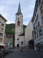
Sights
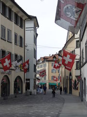
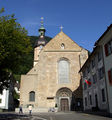
The modern part of the city is to the west, but the old portion, with all the historical buildings, is to the east. Here is the cathedral church of St Luzius (who is the patron of Coire, and is supposed to be a 2nd-century British king Lucius, though really the name has probably arisen from a confusion between Lucius of Cyrene, miswritten curiensis, with the Roman general Lucius Munatius Plancus, who conquered Raetia).
Built between 1178 and 1282, on the site of an older church, it contains many curious medieval antiquities (especially in the sacristy), as well as a picture by Angelica Kauffmann, and the tomb of the great Grisons political leader (d. 1637) Jenatsch. Opposite is the Bishops Palace, and not far off, is the Episcopal Seminary (built on the ruins of a 6th-century monastic foundation). Not far from these ancient monuments is the new Raetian Museum, which contains a great collection of objects relating to Raetia (including the geological collections of the Benedictine monk of Disentis Abbey, Placidus a Spescha (1752–1833), who explored the high snowy regions around the sources of the Rhine). One of the hospitals was founded by the famous Capuchin philanthropist, Father Theodosius Florentini (1808–1865), who was long the Romanist cur of Coire, and whose remains were in 1906 transferred from the cathedral here to Ingenbohl (near Schwyz), his chief foundation. The Romano-Gothic cathedral where lie the remains of Jörg Jenatsch was begun by Bishop Tello (758-73), has a highly interesting crypt; it contains remarkable paintings by Dürer and Holbein.
In this town you may also visit the Giger Bar designed by the Swiss artist H. R. Giger, the Old Town, the art gallery, and the natural museum.
Heritage sites of national significance
Chur is home to many buildings or other sites that are listed as Swiss heritage sites of national significance. There are two archeological sites in Chur, the old city which is a medieval city and Welschdörfli a prehistoric settlement and roman Vicus. There are four archives or libraries; the bishop's palace (library and archive), the Cantonal Library, the Cantonal Archive of Graubünden and the city archive of Chur. There are also four museums on the list; the Bündner Kunstmuseum (Art Museum), Bündner Naturmuseum (Natural History Museum), the Dommuseum and the Rätisches Museum in the Haus Buol. Three churches are included in the list; The cathedral of the Assumption, the Catholic Church of St. Luzi and the reformed church of St. Martin. There are 15 other buildings that are also heritage sites; these include the Alte Kaserne at Zeughaus 3 (the Old Armory), the Confederation Paper Mill, the Main Post Office, the new Town Hall, headquarters of the Rhätischen Bahn and several old patrician houses.[5]
 Bündner Kunstmuseum (Art Museum) |
 St. Maria Himmelfahrt (cathedral of the Assumption) |
 Church of St. Martin |
 Altes Gebäude (Old Building), now home of Cantonal court |
Demographics
Chur has a population (as of 31 December 2009) of 33,377.[1] As of 2008[update], 17.8% of the population was made up of foreign nationals.[6] Over the last 10 years the population has grown at a rate of 7.6%. Most of the population (as of 2000[update]) speaks German (81.0%), with Romansh being second most common ( 5.4%) and Italian being third ( 5.1%).[4]
As of 2000[update], the gender distribution of the population was 47.9% male and 52.1% female.[7] The age distribution, as of 2000[update], in Chur is; 3,087 children or 9.4% of the population are between 0 to 9 years old. 1,602 teenagers or 4.9% are 10 to 14, and 2,194 teenagers or 6.7% are 15 to 19. Of the adult population, 4,770 people or 14.5% of the population are between 20 to 29 years old. 5,517 people or 16.7% are 30 to 39, 4,616 people or 14.0% are 40 to 49, and 4,254 people or 12.9% are 50 to 59. The senior population distribution is 3,090 people or 9.4% of the population are between 60 to 69 years old, 2,314 people or 7.0% are 70 to 79, there are 1,307 people or 4.0% who are 80 to 89, there are 233 people or 0.7% who are 90 to 99, and 5 people or 0.0% who are 100 or more.[6]
In the 2007 federal election the most popular party was the SP which received 34% of the vote. The next three most popular parties were the SVP (31.8%), the CVP (16.4%) and the FDP (16.3%).[4]
The entire Swiss population is generally well educated. In Chur about 70.3% of the population (between age 25-64) have completed either non-mandatory upper secondary education or additional higher education (either University or a Fachhochschule).[4]
Chur has an unemployment rate of 1.8%. As of 2005[update], there were 152 people employed in the primary economic sector and about 33 businesses involved in this sector. 3,838 people are employed in the secondary sector and there are 305 businesses in this sector. 21,087 people are employed in the tertiary sector, with 1,957 businesses in this sector.[4]
From the 2000 census[update], 14,713 or 44.6% are Roman Catholic, while 12,199 or 37.0% belonged to the Swiss Reformed Church. Of the rest of the population, there are 15 individuals (or about 0.05% of the population) who belong to the Christian Catholic faith, there are 589 individuals (or about 1.79% of the population) who belong to the Orthodox Church, and there are 532 individuals (or about 1.61% of the population) who belong to another Christian church. There are 13 individuals (or about 0.04% of the population) who are Jewish, and 917 (or about 2.78% of the population) who are Muslim. There are 424 individuals (or about 1.29% of the population) who belong to another church (not listed on the census), 1,998 (or about 6.06% of the population) belong to no church, are agnostic or atheist, and 1,589 individuals (or about 4.82% of the population) did not answer the question.[6]
Historic population
The historical population is given in the following table:[8]
| year | population | Swiss | % German Speaking | % Italian Speaking | % Romansh Speaking | % Protestant | % Roman Catholic |
|---|---|---|---|---|---|---|---|
| 13th Century | 1,000-1,500 | ||||||
| End of 15th Century | ca. 1,500 | ||||||
| 1780 | 2,331 | ||||||
| 1860 | 6,990 | 6,373 | 60.8% | 39.1% | |||
| 1880a | 8,753 | 7,866 | 86.6% | 3.2% | 11.3% | 73.6% | 27.8% |
| 1888 | 9,259 | 8,094 | 84.2% | 2.7% | 12.5% | 70.4% | 29.5% |
| 1900 | 11,532 | 9,687 | 80.5% | 5.9% | 12.7% | 65.6% | 34.4% |
| 1910 | 14,639 | 12,042 | 79.4% | 8.0% | 11.6% | 62.8% | 36.8% |
| 1930 | 15,574 | 13,685 | 83.0% | 5.3% | 10.8% | 62.8% | 36.7% |
| 1950 | 19,382 | 17,852 | 83.2% | 5.2% | 10.2% | 60.4% | 38.5% |
| 1970 | 31,193 | 26,332 | 75.6% | 9.7% | 10.6% | 49.1% | 49.6% |
| 1990 | 32,868 | 27,259 | 78.2% | 6.2% | 6.9% | 42.7% | 48.5% |
| 2000 | 32,989 | 27,061 | 81.0% | 5.1% | 5.4% | 38.5% | 44.6% |
- ^a Language adds up to over 100% due to counting all languages, not just first language.
Weather
Chur has an average of 105.7 days of rain per year and on average receives 814 mm (32 in) of precipitation. The wettest month is August during which time Chur receives an average of 103 mm (4.1 in) of precipitation. During this month there is precipitation for an average of 11.6 days. The driest month of the year is March with an average of 47 mm (1.9 in) of precipitation over 11.6 days.[9]
| Climate data for Chur | |||||||||||||
|---|---|---|---|---|---|---|---|---|---|---|---|---|---|
| Month | Jan | Feb | Mar | Apr | May | Jun | Jul | Aug | Sep | Oct | Nov | Dec | Year |
| Average high °C (°F) | 4.1 (39.4) |
6.3 (43.3) |
10.3 (50.5) |
14 (57) |
18.6 (65.5) |
21.5 (70.7) |
23.5 (74.3) |
22.7 (72.9) |
19.9 (67.8) |
15.5 (59.9) |
8.8 (47.8) |
4.1 (39.4) |
14.1 (57.4) |
| Daily mean °C (°F) | -0.5 (31.1) |
1.3 (34.3) |
4.8 (40.6) |
8.3 (46.9) |
12.7 (54.9) |
15.6 (60.1) |
17.7 (63.9) |
16.9 (62.4) |
14.2 (57.6) |
9.7 (49.5) |
3.9 (39) |
-0.1 (31.8) |
8.7 (47.7) |
| Average low °C (°F) | -3.9 (25) |
-2.4 (27.7) |
0.4 (32.7) |
3.4 (38.1) |
7.2 (45) |
10.2 (50.4) |
12.1 (53.8) |
11.8 (53.2) |
9.3 (48.7) |
5.3 (41.5) |
0.3 (32.5) |
-3.3 (26.1) |
4.2 (39.6) |
| Precipitation mm (inches) | 52 (2.05) |
51 (2.01) |
47 (1.85) |
51 (2.01) |
75 (2.95) |
91 (3.58) |
96 (3.78) |
103 (4.06) |
77 (3.03) |
51 (2.01) |
65 (2.56) |
58 (2.28) |
814 (32.05) |
| Avg. precipitation days | 7.9 | 7 | 8.2 | 8.5 | 10.7 | 11.2 | 10.4 | 11.6 | 8.3 | 6.2 | 7.5 | 8.2 | 105.7 |
| Source: MeteoSchweiz [9] | |||||||||||||
Transportation
Chur is 120 km by rail from Zurich, and is the meeting-point of the routes from Italy over many alpine passes (Lukmanier Pass, Splugen Pass, and San Bernardino Pass), as well as from the Engadine (Albula Pass, Julier Pass), so that it is the centre of an active trade (particularly in wine from the Valtelline), though it also has a few local factories.
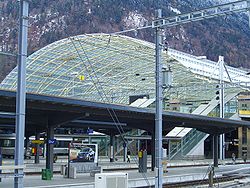
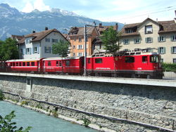
The city's main railway station has the SBB-CFF-FFS lines link with the RhB (Rhaetian Railway) lines. While the SBB lines serve most of Switzerland, most of Graubünden's rail traffic is served by Rhaetian state railways. One of the lines (to Arosa) uses on-street running through streets in the centre of Chur and Sand in order to reach the station - see Chur stadtbahn.
There are three other railway stations in Chur:
- Chur Stadt (on the Chur-Arosa line)
- Chur West
- Chur Wiesental
There is also a bus station on top of the railway station.
Chur is linked by a motorway—the A13.
See also
- Bishop of Chur for the list of incumbents
- Mario Frick - Liechtensteiner football player, born in Chur.
- H. R. Giger - Artist born in Chur.
- Carl Hilty - philosopher and lawyer born in Chur
- Angelica Kauffmann - Artist born in Chur
- Nino Niederreiter - Canadian junior hockey player drafted 5th overall by the New York Islanders
- Johanna Spyri
- List of mayors of Chur
Sources and references
- ↑ 1.0 1.1 Swiss Federal Statistical Office, MS Excel document – Bilanz der ständigen Wohnbevölkerung nach Kantonen, Bezirken und Gemeinden (German) accessed 25 August 2010
- ↑ Pre-Roman History in German, French and Italian in the online Historical Dictionary of Switzerland.
- ↑ Schibler, J. 2006. The economy and environment of the 4th and 3rd millennia BC in the northern Alpine foreland based on studies of animal bones. Environmental Archaeology 11(1): 49-65
- ↑ 4.0 4.1 4.2 4.3 4.4 Swiss Federal Statistical Office accessed 27-Oct-2009
- ↑ Swiss inventory of cultural property of national and regional significance 21.11.2008 version, (German) accessed 27-Oct-2009
- ↑ 6.0 6.1 6.2 Graubunden Population Statistics (German) accessed 21 September 2009
- ↑ Graubunden in Numbers (German) accessed 21 September 2009
- ↑ Chur in German, French and Italian in the online Historical Dictionary of Switzerland.
- ↑ 9.0 9.1 "Temperature and Percipitation Average Values-Table, 1961-1990" (in German, French, Italian). Federal Office of Meteorology and Climatology - MeteoSwiss. http://www.meteoswiss.admin.ch/web/de/klima/klima_schweiz/tabellen.html. Retrieved 8 May 2009., the weather station elevation is 556 meters above sea level.
- Chur (municipality) in Romansh, German, French and Italian in the online Historical Dictionary of Switzerland.
 This article incorporates text from a publication now in the public domain: Chisholm, Hugh, ed (1911). Encyclopædia Britannica (Eleventh ed.). Cambridge University Press. as Coire
- A. Eichhorn, Episcopatus Curiensis (St Blasien, 1797)
- W. von Juvalt, Forschungen fiber die Feudalzeit im Curischen Raetien, 2 parts (Zurich, 1871)
- C. Kind, Die Reformation in den Bistumern Chur und Como (Coire, 1858)
- Conradin von Moor, Geschichte von Curraetien (2 vols., Coire, 1870–1874)
- P. C. you Planta, Des alte Raetien (Berlin, 1872); Idem, Die Curraetischen Herrschaften in der Feudalzeit (Bern, 188i); Idem, Verfassungsgeschichte der Stadt Cur im Mittelalter (Coire, 1879); Idem, Geschichte von Graubünden (Bern, 1892).
- This article incorporates text from a publication now in the public domain: Herbermann, Charles, ed (1913). Catholic Encyclopedia. Robert Appleton Company.
- Principality of Liechtenstein homepage on religion
External links
- City of Chur - official website (German)
- Chur tourism office (German)
- Chur tourism office - English
|
|||||||
|
|||||||||||||