Don Valley Parkway
|
|
|||||||
|---|---|---|---|---|---|---|---|
| The DVP Route of Heroes |
|||||||
 |
|||||||
| Route information | |||||||
| Maintained by City of Toronto | |||||||
| Length: | 15.0 km (9.3 mi) | ||||||
| History: | Proposed in 1954 Opened August 31, 1961 – November 17, 1966[1] |
||||||
| Major junctions | |||||||
| North end: | (continues as Highway 404) |
||||||
| Bloor Street / Danforth Avenue Eglinton Avenue |
|||||||
| South end: | |||||||
| Location | |||||||
| Major cities: | Toronto | ||||||
| Highway system | |||||||
|
Roads in Ontario
|
|||||||
The Don Valley Parkway (DVP) is a controlled-access six-lane expressway in Toronto, Ontario, Canada. The expressway connects the Gardiner Expressway in downtown Toronto with Highway 401. North of Highway 401, the expressway continues as Highway 404 to Newmarket. It runs through the park lands of the Don River Valley, after which it is named. The parkway is patrolled by the Toronto Police Service and has a maximum speed limit of 90 km/h (56 mph).
The parkway was the second expressway to be built by Metropolitan Toronto (Metro). Planning for it began in 1954, the year of Metro's formation. The first section opened in 1961 and the entire route was completed by the end of 1966. South of Bloor Street, the expressway was constructed over existing roadways. North of Bloor Street, the expressway was built on a new alignment through the valley, requiring the removal of several hills, rerouting of the Don River and the clearing of green space. North of Eglinton Avenue, the expressway follows the former Woodbine Avenue right-of-way north to Highway 401.
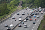
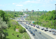
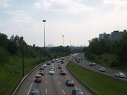
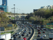
The parkway is one of the busiest municipal roads in the city – some sections carry an average of 100,000 vehicles a day. Planned as part of a larger expressway network within Toronto, it was one of the few expressways built before the public opposition which cancelled many of the others. The parkway operates well beyond its intended capacity of 60,000 vehicles per day and is known for its daily traffic jams.
Contents |
Route description
The Don Valley Parkway begins at an interchange with the Gardiner Expressway near the mouth of the Don River. From there, it runs northwards on the eastern bank of the valley, between the river and the developed city to the east. Beyond the southern, older section of the city, the valley widens and the expressway continues northwards through the park lands along the river to Don Mills Road. The route then leaves the valley, rises to meet Eglinton Avenue, descends into the valley again and goes through the park lands of Milne Hollow to Lawrence Avenue. It then ascends to meet York Mills Road and ends at Ontario Highway 401.
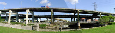
Complex bridge structure of the Don Valley Parkway, Gardiner Expressway and Lake Shore Boulevard interchange.
|
South of the Forks
At its southern end, near the mouth of the Don River, the parkway begins in a multiple-level interchange with the ground-level Lake Shore Boulevard, and the elevated Gardiner Expressway which is directly above the Boulevard. A off-ramp from the parkway provides access to the westbound Gardiner and a northbound on-ramp provides access from the eastbound Gardiner. The ramps thus provide access to the section of the Gardiner west of the parkway, which continues to the downtown financial district of Toronto. Eastbound access at the southern end of the parkway is available from the off-ramp to Lake Shore Boulevard. Just north of the interchange the ramps descend from the Gardiner, pass under the Canadian National (CNR) /GO Toronto railway viaduct and merge with the Lake Shore ramps shortly afterwards.
From the interchange, the DVP proceeds north as a four-lane highway on a straight course along the east bank of the channelized Don River, passing beneath Eastern Avenue then veering slightly to the east as it passes below Queen Street East.[2] On- and off-ramps project northward from Eastern Avenue, each adding a lane to both carriageways. The expressway continues northward, with the Don River sandwiched between the highway and Bayview Avenue. It passes beneath Dundas and Gerrard Streets and then rises onto the 'Don Flats' plateau at Riverdale Park. In this section, the elevation of the highway is close to the level of the river and is liable to flood after heavy rains, as occurred in June 2010.[3]
North from Riverdale Park, the valley widens considerably.[4] The expressway rises from the floor of the valley and passes beneath the towering Prince Edward Viaduct bridge, which connects Bloor Street with Danforth Avenue and carries a subway line.[5] The highway runs along the eastern wall of the valley for the next several kilometres,[4] rising and dipping repeatedly.[6]
.jpg)
The expressway curves eastward into a cut in the hillside as it passes the 'Half-mile' railway bridge. Immediately to the north, it meets the Bayview Avenue – Bloor Street interchange.[7] The long off-ramp to these roads was the beginning of the parkway in 1961.[8] The off-ramp was later proposed as the eastern terminus of the proposed Crosstown Expressway. This expressway, opposed by the City of Toronto, was never built.[9] It was projected to be built only after the completion of the Spadina Expressway, which itself was cancelled in 1971.[10]
Just north of the Bayview–Bloor interchange, the expressway passes over Pottery Road. To the east is Todmorden Mills, a collection of historic buildings and a former industrial site, the original "Don Mills".[11] The nearby pond was a section of the Don River cut off by the parkway construction. Further north, to the west where the highway crosses Beechwood Avenue, is Crothers' Woods, a restoration site.[12]
The expressway continues due east along the southern edge of the valley.[4] The opposing lanes split as the expressway passes beneath the Leaside Viaduct, the southbound lanes at a lower level. The lanes rejoin as they approach the Don Mills Road interchange at the "forks of the Don". Just east of the Don Mills Road interchange, several large white sculptures resembling human teeth are installed on both sides of the road. The sculptures, called The Elevated Wetlands, are examples of "eco-art" and have become a landmark. The sculptures resemble concrete but are made of plastic. They function as rain water collectors, filtering the water before releasing it into the Don River.[13]
North to Highway 401
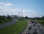
The expressway crosses Taylor-Massey Creek and the East Don River, and climbs out of the valley, swinging northwards toward Eglinton Avenue.[4] In this section, the expressway passes around the apartment buildings of Flemingdon Park. The lanes split again before the underpass at Spanbridge Road, the road that connects a three-tower complex of apartments to the east of the parkway with Flemingdon Park to the west. The lanes then pass beneath the Gatineau Hydro Corridor and reconnect south of the Eglinton interchange.[14]
As it crosses Eglinton, the expressway passes a business park to the west and the Concorde Place commercial and condominium development to the east. The expressway then begins to descend back into the East Don Valley. It passes beneath Wynford Drive and two railways (the CPR Midtown line and the CNR/Richmond Hill GO line) before reaching Lawrence Avenue East, one of the few remaining cloverleaf interchanges in Ontario.[15] This area, known as Milne Hollow, is partially forested, some of the land being conservation reserves. Passing beneath Lawrence and back over the East Don River, the expressway begins climbing out of the valley once more. It reaches the top of the valley and curves along a plateau before passing over York Mills Road. Residential sub-divisions are present along both sides of the road, isolated from the expressway by noise barriers, from north of Lawrence to the 401 interchange.[16] After rising to meet the interchange with the 401, it widens to four lanes and diverges into two branches: two lanes continuing north as the 404, the other three serving Highway 401.[17]
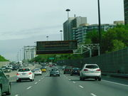
The entire length of the parkway utilizes the RESCU Traffic Management System, which was installed in 1994.[18] Like the similar COMPASS system on provincial freeways, RESCU combines in-pavement sensors with traffic cameras and changeable message signs (6 fixed and 10 portable) to alert drivers of accidents, traffic conditions and upcoming closures in order to manage traffic flow.[18] The message signs also frequently display non-urgent messages to motorists, such as future construction, safety messages and smog alerts.[19]
The RESCU Traffic Cameras are located at regular intervals along the parkway. The cameras, which are operated by the City of Toronto, can be viewed on television and online. The cameras are located on poles and are fixed in direction. There are 16 camera locations on the parkway. Most have one camera for northbound and one for southbound traffic. RESCU operators monitor the cameras for emergency purposes; local radio and television media use the service for traffic reports. [18][20]
| Direction | ||
|---|---|---|
| Segment | Southbound | Northbound |
| Gardiner to Dundas | 39,587 | 48,028 |
| Dundas to Bloor | 52,662 | 64,503 |
| Bloor to Don Mills | 53,710 | 66,781 |
| Don Mills to Eglinton | 78,619 | 66,245 |
| Eglinton to Lawrence | 90,764 | 84,619 |
| Lawrence to York Mills | 87,432 | 83,880 |
| York Mills to 401 | 93,852 | 92,125 |
| Average weekday traffic volume per 24-hour period, surveyed from 2002 to 2006[21] | ||
Traffic congestion
The Don Valley Parkway, along with the Gardiner Expressway, is one of Toronto's busiest municipal routes. It is the sole north–south expressway into Toronto's downtown, a role it was not designed to support. The parkway was planned as one of a series of expressways to provide commuter routes to downtown from the expanding suburbs. Two other unbuilt expressways were planned: the Scarborough Expressway, expected to handle traffic between downtown and the eastern suburbs, and the Spadina Expressway, expected to serve traffic from the north-west.[22] By the early 1980s, traffic volumes on the parkway exceeded capacity,[23][24] and today, the parkway has significant traffic congestion on most days, earning it the affectionate nickname of the "Don Valley Parking Lot".[6]
The section south of the 401 is often congested. Congestion in the southbound lanes is attributed to the number of lanes merging from Highways 401 and 404 into the parkway and the lane changing that results from merging traffic from the 401 clashing with exiting traffic to the nearby York Mills exit.[25] Congestion in the northbound lanes is attributed to truck traffic coping with the steep grade of the valley, lane changing, and insufficient advanced signage for Highway 401. Most traffic in this section travels north on the 404, but only two of the five lanes lead to it.[26]
History
The construction of the Don Valley Parkway changed the Don River valley. While industrial areas existed both near the mouth of the Don River and the area of today's Leaside Bridge, several natural areas remained in the areas where the steep sides of the valley had dissuaded urban development on a large scale. The post-war growth period of Toronto provided an impetus to build a new automobile route into central Toronto, and the route through the valley was chosen as a way to avoid expropriation of existing development and provide access for new development in the Metropolitan Toronto region. The construction of the six-lane highway modified the valley through the removal of hills, other earth works and the rerouting of the Don River. Since completion, the parkway has not been changed significantly, other than adding one partial interchange at Wynford Drive and the updating of its infrastructure to current standards.
The Don River valley, formed during the last ice age, has played an important role in the development of Toronto from its beginning as the Town of York. Utilizing the power of the river, the first sawmill was erected at today's Todmorden Mills by 1795[27] and other industry was founded soon after, including a grist mill, paper mill and brewery by 1828.[28] Railways were introduced into the valley after 1850 with the building of railways into Toronto. By 1900, the Don River south of today's Bloor Street was straightened into a channel for boating purposes, with roadways and industry built on both banks.[29] North of Bloor Street, the wide valley floor became dominated by industrial concerns of the Taylor family, including the Don Valley Brick Works. The area from the Forks of the Don and north along the river valleys had been lumbered and farmed, such as at Milne Hollow, but several natural areas remained by the 1950s.
The Don Valley Parkway was not the first highway planned through the valley. In the 1930s, a "speedway" through the lower valley was promoted as possible depression relief. Unlike today's parkway, this road would have curved northwest near the Don Valley Brick Works and connected to Mount Pleasant at Davisville.[1] This idea was never realized, and all but disappeared for several years. In 1939, city transportation planner Norman Wilson proposed a boulevard that would follow the valley into the northeast.[30] In 1954, the Metropolitan Toronto federation was established. Its mission from the start was to build the infrastructure to support the rapid growth in population of the Toronto area. One of its first priorities was to build an expressway network, which included an expressway through the Don River valley.[31][32]
Recognizing the value of the natural spaces of the valley, conservationist Charles Sauriol founded the Don Valley Conservation Association,[33] which led to the formation of the Don Valley Conservation Authority (DVCA) in 1948.[34] The DVCA, a provincial government agency, promoted conservation of the valley with rail tours and public events.[35] In October 1954, flooding caused by Hurricane Hazel caused the destruction of bridges and buildings in the valley. As a consequence of the destruction on the Don and other rivers, the provincial government of Ontario banned development on river floodplains. In 1957, the Metropolitan Toronto and Region Conservation Authority (MTRCA) was formed, merging all conservation authorities responsible for Toronto watersheds (including the DVCA), with greater powers to manage valley lands.[34] The MTRCA began expropriating privately-owned land in the valley for flood control, often creating or conserving open space uses. Sauriol, who was by then an employee of the MTRCA,[36] was one of the few to speak out against the parkway project. Sauriol's cottage at the Forks of the Don would be expropriated by Metro Toronto for the parkway,[31][37] although much of his land is now part of the Charles Sauriol Conservation Reserve, which extends from the Forks of the Don, along the East Don to Milne Hollow at Lawrence Avenue, visible from the parkway.[33]
Construction
The design of the project was contracted to the engineering consortium of Fenco-Harris, which completed the plans in the fall of 1955. The project included extending Bayview Avenue south along the Lower Don valley, and the realignment of Lawrence Avenue over the East Don River. The design for the section north of the Don River mouth incorporated the existing river-side Don Roadway on the east side of the River. The design also incorporated a section of the old Don Mills Road leading up from the River, north of Gerrard, to Broadview Avenue and Danforth Avenue into the highway as a northbound on-ramp from Danforth. The project was designed to carry 60,000 vehicles per day.[31] The plan, estimated to cost $28.674 million,[38] was approved by Metro Council in early 1956.[31][1]
The first planned route of the parkway was to follow the lower Don Valley before turning north and continuing along the Don Mills Road right-of-way north to the Toronto Bypass (today's Highway 401). Edward P. Taylor, developer of the Don Mills subdivision, situated at Don Mills Road and Lawrence Avenue, protested the plan heavily and the path was rerouted along the CPR railway from Don Mills Road and Eglinton Avenue north-east to meet the Woodbine Avenue right-of-way at Lawrence Avenue, and proceeded north to the Toronto Bypass. To facilitate the Flemingdon Park development, located south-east of Don Mills Road and Eglinton, the entire planned route south of Lawrence to the present interchange at Don Mills Road was moved east to its current alignment.[7]
Construction of the parkway began in 1958[31] and the first section of the parkway, from Bloor Street to Eglinton Avenue, opened on August 31, 1961,[1] initially without an interchange at Don Mills Road.[39] Building the section within the valley required significant civil engineering, including the rerouting of the Don River and the removal of two hills. Tumper's Hill, located near the Don Mills Road interchange, stood 36 metres (118 ft) higher than it does today.[31][40] Sugar Loaf Hill, shaped like a cone, which stood alone in the shadow of the Prince Edward Viaduct where Bayview Avenue passes today, was removed completely. The 1,250,000 m3 (44,000,000 cu ft) of soil was used as fill for the parkway.[39]
The section from Eglinton Avenue to Lawrence Avenue opened on October 31, 1963.[1][31] This was followed by the connection to the Gardiner Expressway, opened in conjunction with the section of the Gardiner from the parkway to Yonge Street on November 4, 1964. Finally, the section between Lawrence Avenue and Sheppard Avenue was opened to traffic on November 17, 1966. The final cost of the project was $40 million ($270 million in 2010 dollars).[1]
Since completion
In 1965, Metro Toronto Chief Coroner Morton Shulman released a report criticizing the lack of safety in the completed section's design of the as yet unfinished expressway.[41] In the first five months of 1965, 136 accidents had caused four deaths and 86 injuries. Among the 'death-dealing' deficiencies corrected were inadequate guardrails, exposed steep slopes and light standards exposed to traffic.[31] Call boxes with emergency telephones were installed on the parkway in 1966.[42] The boxes, attached to street lighting on the right shoulder, provided a direct line for help from the then Ontario Motor League, now part of the CAA.[42] Today, the RESCU Traffic Management System monitors the highway and can call for emergency help.[43]
On April 18, 1969, the slope behind Davies Crescent (just west of Don Mills Road) gave way after heavy rain, covering the northbound lanes and part of the southbound lanes with up to 90 centimetres (3 ft) of mud. There were only minor injuries. The slope, which had had its trees removed for the building of the expressway, was covered with sod and stakes to hold the soil.[44]
In the late 1980s, a new partial-access interchange was built at Wynford Drive to provide access between the parkway and the Concorde Place development. The new partial-access interchange was paid for by the developers.[45] The ramp connecting Wynford with the northbound parkway required a tunnel under the Canadian Pacific Railway (CPR) Midtown railway lines. To avoid delaying trains on the vital freight line, a prefabricated concrete arch was jacked into the embankment, 2 feet (0.61 m) at a time, over 12 days. This was the first North American use of such a technique.[45]
From 1986 to 1988, the City studied traffic congestion in the 'Don Valley Corridor', an area from Leslie Street east to Victoria Park Avenue. To improve traffic in the area, the proposed solutions were extending Leslie Street south of Eglinton Avenue and south-west to Bayview Avenue; widening Don Mills Road; and expanding the parkway.[24] Two proposals were put forward for approval: the Leslie Street extension and widening of Don Mills Road. Don Mills Road was widened from four to six lanes with the new lanes to be high occupancy/bus lanes.[46] The Leslie Street extension was approved by East York and North York, but was abandoned by Metro Council in 1993, after the provincial government refused to subsidize its construction.[47]
In 1989, a public meeting was held on the future of the Don River, which was widely known for its pollution and the Don Valley, considered an "industrial wasteland,"[29] which had seen its last industrial use (the Taylor, later Domtar, Paper Mill) close in 1982.[29] The Toronto City Council formed the "Task Force to Bring Back the Don", an organization of volunteers to work on conservation efforts in the Don Valley. Since that time, the task force has planted some 40,000 trees in the valley, planted thousands of wildflowers and overseen the creation of wetlands along the River.[29] Efforts continue to ameliorate the water quality of the River and improve the environment of the surrounding Valley lands.[29] These efforts can be seen in the "Crother's Woods" north of Bloor Street and the Chester Marsh just south of Bloor Street, alongside the parkway.[48]
In 2001, Toronto City Councillor Paul Sutherland proposed to add two toll lanes in each direction along the parkway, from the 401 to Eglinton Avenue. From Eglinton Avenue south, one lane in each direction would be added. The proposal was criticized by transportation experts such as Transport 2000 for encouraging driving to downtown. Sutherland estimated the cost of the proposal at $200 million.[49]
On May 11, 2007, GO Transit announced a plan to put dedicated bus lanes on the centre median of the parkway, to allow its buses to bypass traffic congestion and promote buses as an alternative to automobiles. The $12 million dollar plan would be paid for by GO. The plan would require testing of soil conditions and an environmental assessment.[50] GO Transit was taken over by the provincial Metrolinx transit agency, and the plan does not appear in the 2008 "Big Move" Regional Transportation Plan of Metrolinx.[51]
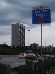
On June 7, 2010, a section of the expressway was dedicated by Toronto mayor David Miller as part of the Route of Heroes. Similar to the Highway of Heroes designation of part of Highway 401, the designation serves to honour fallen Canadian soldiers. The designation applies to the portion of the parkway between Highway 401 and Bloor Street by which repatriation processions travel when transporting the remains of Canadian soldiers from CFB Trenton to the Office of the Coroner in downtown Toronto.[52]
Future
A proposal to allow GO Transit buses to use the left shoulder to pass slow traffic was approved in June 2010 by Toronto City Council.[53] The centre median shoulders, starting with the section between Lawrence Avenue and and a point 458 metres (1,500 ft) north of York Mills Road,[53] will be opened to GO Transit buses to pass other traffic, at no more than 20 km/h (12 mph) faster, when the other traffic is going at 60 km/h (37 mph) or less.[54][55] City Council directed the General Manager of Transportation Services to report on the feasiblity of future bus bypass lanes in the segments from Pottery Road to Don Mills Road and between Don Mills Road and Eglinton Avenue East.[53]
During the 2010 municipal election, mayoral candidate Sarah Thomson proposed a road toll for the Gardiner Expressway and Don Valley Parkway, drawing comments from critics and supporters across the city.[56] [57]
Two projects are underway that may change the parkway's southern end. Waterfront Toronto is conducting an environment assessment to evaluate replacing, modifying or removing the Gardiner Expressway east of Jarvis Street.[58] The parkway would then end at Lake Shore Boulevard. A second proposal, known as the Don Mouth Naturalization and Port Lands Flood Protection project, seeks to recreate the natural mouth of the Don River into Toronto Harbour with the surrounding parkland. The project is managed by the Toronto and Region Conservation Authority and Waterfront Toronto.[59] The ramps between the parkway and the Gardiner are directly over the Don River channel.
Exit list
The Don Valley Parkway is located entirely within Toronto.
| km | Destinations | Notes |
|---|---|---|
| Don Valley Parkway continues west as the |
||
| 0.0 | Lake Shore Boulevard via Don Roadway | Southbound exit and northbound entrance; formerly Highway 2 |
| 0.8 | Richmond Street / Adelaide Street, Eastern Avenue – Downtown | Southbound exit and northbound entrance; Adelaide exits to northbound parkway, southbound parkway exits to Richmond Street |
| 1.2 | Queen Street East | Northbound entrance |
| 1.6 | Dundas Street East | Northbound entrance |
| 2.7 | Bloor Street | Northbound entrance |
| 3.8 | Bayview Avenue, Bloor Street / Danforth Avenue | Formerly Highway 5; no access between Bayview and Bloor / Danforth |
| 7.0 | Don Mills Road | No access to northbound parkway from southbound Don Mills |
| 10.0 | Eglinton Avenue | |
| 10.7 | Wynford Drive | Southbound exit and northbound entrance |
| 11.8 | Lawrence Avenue | |
| 14.0 | York Mills Road | |
| 15.0 | ||
| Don Valley Parkway continues north as |
||
See also
- Ride for Heart
References
- Sources
- ↑ 1.0 1.1 1.2 1.3 1.4 1.5 Filey 2006, pp. 151–153.
- ↑ Rand McNally Canada (2010). Toronto & Area Map Book [map]. Cartography by Perly's. ISBN 978-0-88640-928-9. p. 3, section D1.
- ↑ O'Neil, Lauren (June 27, 2010). "Union Subway Station, DVP, Major Downtown Roads Closed due to Flooding". Toronto Star. http://www.thestar.com/news/gta/transportation/article/829566--union-subway-station-dvp-major-downtown-roads-closed-due-to-flooding. Retrieved June 29, 2010.
- ↑ 4.0 4.1 4.2 4.3 Whiteson 1982, pp. 137–139.
- ↑ Sullivan, Olena. "Building the Bloor Viaduct – 1916". Heritage Toronto. http://www.heritagetoronto.org/discover-toronto/photos/building-bloor-viaduct-1916. Retrieved April 28, 2010.
- ↑ 6.0 6.1 Taylor, Bill (July 29, 2007). "A Picture and a Thousand Words". The Toronto Star. http://www.thestar.com/sciencetech/ideas/article/240950. Retrieved April 25, 2010.
- ↑ 7.0 7.1 McClelland, Stewart (2007) pp. 242–243
- ↑ "Section of Don Vally Parkway Gets its Ribbon Sliced Aug. 31". The Globe and Mail (Toronto): p. 13. July 11, 1961.
- ↑ "Board Angry at Proposals For Expressway, Extension". The Globe and Mail (Toronto): p. 5. January 21, 1965.
- ↑ Baker, Alden (June 4, 1971). "Cabinet Decides to Halt Spadina". The Globe and Mail (Toronto): p. 1.
- ↑ Darke 1995, p. 9.
- ↑ "Bringing Back The Don: Lower Don Map". City of Toronto. http://www.toronto.ca/don/lower_don_map_large.htm. Retrieved May 5, 2010.
- ↑ Goddard, Peter (March 12, 2007). "'Eco-art' Used to Beautify Border". The Toronto Star. http://www.thestar.com/News/article/190781. Retrieved May 28, 2010.
- ↑ RInC (2009) Hydro Corridor Projects. City of Toronto. (Report). Retrieved May 5, 2010.
- ↑ Peter Heiler Ltd (2010). Ontario Back Road Atlas [map]. Cartography by MapArt. ISBN 978-1-55198-226-7.
- ↑ Google, Inc. Google Maps – Land Use in the Vicinity of the Don Valley Parkway North of Lawrence Avenue [map]. Cartography by Google, Inc. Retrieved July 19, 2010.
- ↑ Google, Inc. Google Maps – Don Valley Parkway Lane Configuration Approaching the 401 Interchange [map]. Cartography by Google, Inc. Retrieved July 19, 2010.
- ↑ 18.0 18.1 18.2 "RESCU Traffic Cameras". City of Toronto. http://www.toronto.ca/rescu/index.htm. Retrieved May 26, 2010.
- ↑ Hall, Joseph (January 22, 2001). "Road Sensors Find Locked Arteries". The Toronto Star: p. B04.
- ↑ "RESCU Traffic Camera Locations". City of Toronto. http://www.toronto.ca/rescu/list.htm. Retrieved May 12, 2010.
- ↑ "Average Weekday , 24 Hour Traffic Volume" (PDF). City of Toronto. http://www.toronto.ca/transportation/publications/brochures/2006volmap.pdf. Retrieved May 5, 2010.
- ↑ Clark, M. (November 1973). Review of the Highway 400 Extension. Metropolitan Toronto Transportation Plan Review. pp. 11–25.
- ↑ Sewell 2009, p. 73.
- ↑ 24.0 24.1 (July 1983) Don Valley Corridor Transportation Study. M.M. Dillon Limited, pp. 79–84. (Report).
- ↑ City of Toronto (2004), Don Valley Corridor Report, pp. 87–88
- ↑ City of Toronto (2004), Don Valley Corridor Report, pp. 89–90
- ↑ Darke 1995, p. 27.
- ↑ Darke 1995, p. 57.
- ↑ 29.0 29.1 29.2 29.3 29.4 "City of Toronto: Bring Back the Don, The Story of the Don". City of Toronto. http://www.toronto.ca/don/watershed.htm. Retrieved August 11, 2010.
- ↑ Sewell 2009, p. 15.
- ↑ 31.0 31.1 31.2 31.3 31.4 31.5 31.6 31.7 Hall, Joseph (March 7, 1992). "DVP: The Scenic Highway We Love to Hate Turns 25". The Toronto Star: pp. A10–A11. http://pqasb.pqarchiver.com/thestar/access/453330651.html?FMT=ABS&FMTS=ABS:FT&type=current&date=Mar+7%2C+1992&author=Joseph+Hall+Toronto+Star&pub=Toronto+Star&edition=&startpage=A.10&desc=DVP+The+scenic+highway+we+love+to+hate+turns+25. Retrieved April 12, 2010.
- ↑ Sewell 2009, p. 67.
- ↑ 33.0 33.1 "Charles Sauriol Conservation Reserve". Toronto Green Community and Toronto Field Naturalists. http://www.lostrivers.ca/points/Sauriol.htm. Retrieved July 27, 2010.
- ↑ 34.0 34.1 Rus 1998, p. 28.
- ↑ Rus 1998, p. 29.
- ↑ Rus 1998, p. 32.
- ↑ Seymour 2000, pp. 58–59, 164–166.
- ↑ "Plan '56 Start on Don Parkway". The Globe and Mail (Toronto): p. 1. December 1, 1955.
- ↑ 39.0 39.1 Smith, Michael (August 13, 1986). "Love it or Hate it, Parkway's 25 years old It was 'Great Sense of Relief' when Don Valley Opened". The Toronto Star: p. A21. http://pqasb.pqarchiver.com/thestar/access/475351391.html?dids=475351391:475351391&FMT=ABS&FMTS=ABS:FT&type=current&date=Aug+13%2C+1986&author=Michael+Smith+Toronto+Star&pub=Toronto+Star&desc=Love+it+or+hate+it%2C+parkway%27s+25+years+old+It+was+%27great+sense+of+relief%27+when+Don+Valley+opened&pqatl=google. Retrieved April 17, 2010.
- ↑ Sauriol 1984, p. 112.
- ↑ "Badly-planned Parkway a Death Trap – Shulman". Toronto Star: pp. 1–2. August 16, 1965.
- ↑ 42.0 42.1 "About Us". Canadian Automobile Association. http://caaneo.ca/about/corporate.jsp. Retrieved April 30, 2010.
- ↑ Chung, Andrew (August 4, 2001). "City Eyes Novel Ways of Unlocking Gridlock". Toronto Star: pp. A01, A04.
- ↑ "Mudslide Closes Northbound Don Parkway". The Globe and Mail (Toronto): p. 1. April 19, 1969.
- ↑ 45.0 45.1 Brennan, Pat (June 8, 1991). "Concorde Place Homes Survive the Opposition". Toronto Star: pp. E1,E19.
- ↑ Byers, Jim (June 22, 1989). "Metro Okays Most Roadwork in 20 Years". Toronto Star: p. A07.
- ↑ Brent, Bob (June 25, 1993). "Metro Shelves Leslie St. Extension". Toronto Star: p. A06.
- ↑ "City of Toronto: Bring Back the Don, Wetlands are the Best Lands". City of Toronto.
- ↑ Moloney, Paul; Hall, Joseph (March 12, 2001). "New Toll Lanes Touted for DVP". Toronto Star: p. A01.
- ↑ Moloney, Paul (May 11, 2007). "Bus-only Lane Pitched for DVP". Transit Toronto. http://transit.toronto.on.ca/archives/data/200705110430.shtml. Retrieved May 1, 2010.
- ↑ "The Big Move". Metrolinx. http://www.metrolinx.com/thebigmove/index.html. Retrieved May 5, 2010.
- ↑ "Fallen Soldiers Honoured with 'Route of Heroes'". CTV News. June 7, 2010. http://toronto.ctv.ca/servlet/an/local/CTVNews/20100607/route-heros-toronto-100607/20100607/?hub=TorontoNewHome. Retrieved June 7, 2010.
- ↑ 53.0 53.1 53.2 "City Council Decisions". City of Toronto. June 8–9, 2010. http://www.toronto.ca/legdocs/mmis/2010/cc/decisions/2010-06-08-cc50-dd.htm. Retrieved August 16, 2010.
- ↑ Jonathon, Jenkins (May 19, 2010). "Buses Cleared to GO on Shoulder". The Toronto Sun: p. 20.
- ↑ "Plan for GO lane on DVP". CBC News. May 18, 2010. http://www.cbc.ca/canada/toronto/story/2010/05/18/go-dvp.html. Retrieved May 20, 2010.
- ↑ "Thomson Proposes a Road Toll for Gardiner, DVP". CTV News. March 18, 2010. http://toronto.ctv.ca/servlet/an/local/CTVNews/20100318/TOR_thomson_subway_100318/20100318. Retrieved May 1, 2010.
- ↑ Lu, Vanessa (April 17, 2010). "Residents Oppose Road Tolls, Poll Finds". The Toronto Star. http://www.thestar.com/yourcitymycity/article/796712--residents-oppose-road-tolls-poll-finds. Retrieved May 1, 2010.
- ↑ The Gardiner Expressway. Waterfront Toronto. (Report). Retrieved May 5, 2010.
- ↑ "On Your Marks: Grow: A New Source for Toronto" (PDF). City of Toronto. http://www.toronto.ca/don/pdf/spring_2010.pdf. Retrieved May 5, 2010.
- Bibliography
- Darke, Eleanor (1995). A Mill Should Be Build Thereon. Natural History Inc. ISBN 0920474896.
- Filey, Mike (2006). "Parkway with a past". Toronto Sketches 9: The Way We Were. Dundurn Press. ISBN 1-55002-613-5. http://books.google.ca/books?id=32KmyGSweuoC&lpg=PA152&ots=kEdJEqVMTC&dq=November%2017%2C%201966%20%22Don%20Valley%20Parkway%22&pg=PA151#v=onepage&q=November%2017,%201966%20%22Don%20Valley%20Parkway%22&f=false. Retrieved April 12, 2010.
- McClelland, Michael; Stewart, Graeme, eds (2007). "The Don Valley Parkway and Suburban Growth". Concrete Toronto: A Guidebook to Concrete Architecture from the Fifties to the Seventies. Coach House Books. ISBN 978-1-55245-193-9. http://books.google.ca/books?id=rqIay255ad0C&lpg=PT245&dq=%22Don%20Valley%20Parkway%22&pg=PT245#v=onepage&q=%22Don%20Valley%20Parkway%22&f=false. Retrieved April 15, 2010.
- Rus, Roslyn (1998). The Don: The History of the Don Valley. Eric S. Rosen Publishing. ISBN 1894023129.
- Seymour, Murray (2000). Toronto's Ravines: Walking the Hidden Country. Boston Mills Press. ISBN 1-55046-322-5.
- Sauriol, Charles (1984). Tales of the Don. Natural History Inc. ISBN 0-920474-30-6.
- Sewell, John (2009). The Shape of the Suburbs: Understanding Toronto's Sprawl. University of Toronto Press. ISBN 978-0-8020-9587-9. http://books.google.ca/books?id=dFA2YUVA57wC&lpg=PA15&dq=%22Don%20Valley%20Parkway%22&pg=PA67#v=onepage&q=%22Don%20Valley%20Parkway%22&f=false. Retrieved April 15, 2010.
- Whiteson, Leon (1982). The Liveable City. Mosaic Press. ISBN 0-88962-152-7.
- Transportation Planning Department (December 2004). Don Valley Corridor Transportation Master Plan – Interim Report. City of Toronto. http://www.toronto.ca/planning/pdf/appendix_g_pt3d.pdf. Retrieved May 5, 2010.
External links
- City of Toronto RESCU Traffic Cameras
- City of Toronto Road Information
- Satellite view of the Don Valley Parkway on Google Maps
- Time lapse video of a drive down the parkway during the morning rush hour.
- Time lapse of evening rush hour on the parkway
|
|||||||||||||||||||||||||||||