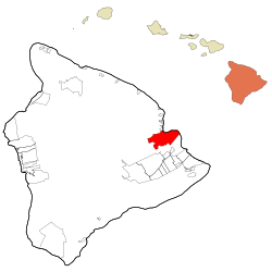
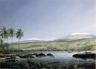
Hilo, Hawaii
| Hilo, Hawaii | |
|---|---|
| — CDP — | |
 |
|
 |
|
| Coordinates: | |
| Country | United States |
| State | Hawaii |
| County | Hawaii |
| Area | |
| - Total | 58.4 sq mi (151.4 km2) |
| - Land | 54.3 sq mi (140.6 km2) |
| - Water | 4.1 sq mi (10.7 km2) |
| Elevation | 59 ft (18 m) |
| Population (2007) | |
| - Total | 47,345 |
| - Density | 750.8/sq mi (289.9/km2) |
| Time zone | Hawaii-Aleutian (UTC-10) |
| ZIP codes | 96720-96721 |
| Area code(s) | 808 |
| FIPS code | 15-14650 |
| GNIS feature ID | 0359187 |
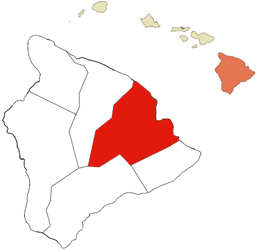
Hilo (pronounced /ˈhiːloʊ/) is the second-largest CDP in the State of Hawaiʻi and the largest settlement on the island of Hawaiʻi with a population of 40,759 during the 2000 census and 47,345 according to a 2007 estimate.
Hilo is the county seat of Hawaiʻi County, Hawaiʻi,[1] and is situated in the South Hilo District. The town overlooks Hilo Bay, and is near two shield volcanoes, Mauna Loa, considered active, and Mauna Kea, a dormant volcano upon which some of the best ground-based astronomical observatories are placed.
Hilo is home to the University of Hawaiʻi at Hilo, as well as the Merrie Monarch Festival, a week-long celebration of ancient and modern hula, which takes place annually after Easter. It is also home to the Mauna Loa Macadamia Nut Corporation, one of the world's leading producers of macadamia nuts. It is served by Hilo International Airport, inside the CDP.[2]
Contents |
History
Although archaeological evidence is scant, people certainly inhabited the areas along Hilo Bay, Wailuku and Wailoa Rivers before the Western world made contact. Known as the Hilo, these aboriginies dominated the high mountaintops until the middle 1800's. Hilo means high mountaintop in the original language of the indigenous peoples who resided on the mountaintops. King Kamehameha, the first king of Hawaii, conquered all the islands and then moved the Hilo mountain settlement to the shore after the arrival of outsiders.
Originally, the name Hilo applied to the whole district of Hilo, now divided into South Hilo District and North Hilo District. When William Ellis visited in 1823, the main settlement in Hilo district was Waiākea on Hilo Bay.[3] Missionaries came to the district in the early to middle 1800s, founding several churches, notably Haili Church, in the area of modern Hilo.
Hilo expanded as sugar plantations in the surrounding area created new jobs and drew in many workers from Asia, making the city a trading center.
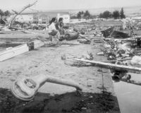
A breakwater across Hilo Bay was begun in the 1900s and completed in 1929. On April 1, 1946, a 7.8 magnitude earthquake near the Aleutian Islands created a fourteen-meter high tsunami that hit Hilo 4.9 hours later, killing 160 people. In response an early warning system, the Pacific Tsunami Warning Center, was established in 1949 to track these killer waves and provide warning. This tsunami also meant the end of the Hawaii Consolidated Railway, and instead the Hawaii Belt Road was built north of Hilo using some of the railbed.[4]
On May 23, 1960, another tsunami, caused by a 9.5 magnitude earthquake off the coast of Chile the previous day, claimed 61 lives allegedly due to people's failure to heed warning sirens. Low-lying bayfront areas of the city on Waiākea peninsula and along Hilo Bay, previously populated, were rededicated as parks and memorials.
Hilo expanded inland beginning in the 1960s. The downtown found a new role in the 1980s as the city's cultural center with several galleries and museums being opened; the Palace Theatre was reopened in 1998 as an arthouse cinema.
Closure of the sugar plantations (including those in Hāmākua) during the 1990s led to a downturn in the local economy, coinciding with a general statewide slump. Hilo in recent years has seen commercial and population growth as the neighboring district of Puna became the fastest-growing region in the state.
Geography and climate
Hilo is located at (19.705520, -155.085918).[5]
Hilo is classified by the United States Census Bureau as a census-designated place (CDP), and has a total area of 58.4 square miles (151.3 km2), 54.3 square miles (140.6 km2) of which is land and 4.2 square miles (10.9 km2) of which (7.10%) is water.
Hilo features a tropical rainforest climate (Koppen Af), with substantial rainfall throughout the course of the year. Hilo's location on the eastern side of the island of Hawaiʻi (windward relative to the trade winds) makes it the wettest city in the United States and one of the wettest cities in the world. An average of around 126 inches (3,200 mm) of rain fell at Hilo International Airport annually between 1971–2000, with 275 days of the year receiving some rain.[6] At some other weather stations in Hilo the annual rainfall is above 200 inches (5,100 mm).[7]
Monthly mean temperatures range from 71.4 °F (21.9 °C) in January to 76.3 °F (24.6 °C) in August. The highest recorded temperature was 94 °F (34 °C) on May 20, 1996, and the lowest 53 °F (12 °C) on February 21, 1962.[8] The wettest year was 1994 with 182.81 inches (4,643.4 mm) and the driest year was 1983 with 68.09 inches (1,729.5 mm). The most rainfall in one month was 50.82 inches (1,290.8 mm) in December 1954. The most rainfall in 24 hours was 27.24 inches (691.9 mm) on November 2, 2000.[9]
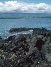
Hilo's location on the shore of the funnel-shaped Hilo Bay also makes it vulnerable to tsunamis.[10]
| Climate data for Hilo | |||||||||||||
|---|---|---|---|---|---|---|---|---|---|---|---|---|---|
| Month | Jan | Feb | Mar | Apr | May | Jun | Jul | Aug | Sep | Oct | Nov | Dec | Year |
| Record high °F (°C) | 92 (33.3) |
92 (33.3) |
93 (33.9) |
89 (31.7) |
94 (34.4) |
90 (32.2) |
91 (32.8) |
93 (33.9) |
92 (33.3) |
91 (32.8) |
92 (33.3) |
93 (33.9) |
94 (34.4) |
| Average high °F (°C) | 79.2 (26.22) |
79.4 (26.33) |
79.2 (26.22) |
79.3 (26.28) |
80.6 (27) |
82.2 (27.89) |
82.5 (28.06) |
83.2 (28.44) |
83.4 (28.56) |
82.7 (28.17) |
80.7 (27.06) |
79.5 (26.39) |
81.0 (27.22) |
| Daily mean °F (°C) | 71.4 (21.89) |
71.5 (21.94) |
72.0 (22.22) |
72.5 (22.5) |
73.7 (23.17) |
75.1 (23.94) |
75.9 (24.39) |
76.3 (24.61) |
76.2 (24.56) |
75.6 (24.22) |
74.0 (23.33) |
72.2 (22.33) |
73.9 (23.28) |
| Average low °F (°C) | 63.6 (17.56) |
63.5 (17.5) |
64.7 (18.17) |
65.6 (18.67) |
66.7 (19.28) |
68.0 (20) |
69.2 (20.67) |
69.4 (20.78) |
69.0 (20.56) |
68.5 (20.28) |
67.2 (19.56) |
64.9 (18.28) |
66.7 (19.28) |
| Record low °F (°C) | 54 (12.2) |
53 (11.7) |
54 (12.2) |
59 (15) |
59 (15) |
61 (16.1) |
62 (16.7) |
63 (17.2) |
61 (16.1) |
62 (16.7) |
58 (14.4) |
55 (12.8) |
53 (11.7) |
| Rainfall inches (mm) | 9.74 (247.4) |
8.86 (225) |
14.35 (364.5) |
12.54 (318.5) |
8.07 (205) |
7.36 (186.9) |
10.71 (272) |
9.78 (248.4) |
9.14 (232.2) |
9.64 (244.9) |
15.58 (395.7) |
10.05 (255.3) |
126.27 (3,207.3) |
| Avg. rainy days (≥ 0.01 in) | 16.3 | 15.7 | 22.6 | 25.4 | 25.4 | 25.4 | 27.4 | 25.9 | 23.3 | 24.0 | 23.6 | 19.8 | 274.8 |
| Sunshine hours | 161.2 | 152.6 | 151.9 | 135.0 | 155.0 | 177.0 | 167.4 | 173.6 | 162.0 | 136.4 | 114.0 | 130.2 | 1,816.3 |
| Source: The Weather Channel (records) [8], NOAA (normals 1971-2000) [6], HKO [11] | |||||||||||||
Demographics
As of the census[12] of 2000, there were 40,759 people, 14,577 households, and 10,101 families residing in the census-designated place. The population density was 750.8 people per square mile (289.9/km²). There were 16,026 housing units at an average density of 295.2/sq mi (114.0/km²). The racial makeup of the CDP was 17.12% White, 0.45% African American, 0.34% Native American, 38.30% Asian, 13.12% Pacific Islander, 0.94% from other races, and 29.74% from two or more races. Hispanic or Latino of any race were 8.78% of the population.
There were 14,577 households out of which 30.6% had children under the age of 18 living with them, 48.5% were married couples living together, 15.2% had a female householder with no husband present, and 30.7% were non-families. 24.1% of all households were made up of individuals and 10.6% had someone living alone who was 65 years of age or older. The average household size was 2.70 and the average family size was 3.19.
In the CDP the population was spread out with 24.7% under the age of 18, 10.3% from 18 to 24, 24.4% from 25 to 44, 23.9% from 45 to 64, and 16.7% who were 65 years of age or older. The median age was 39 years. For every 100 females there were 95.9 males. For every 100 females age 18 and over, there were 91.9 males.
The median income for a household in the CDP was $39,139, and the median income for a family was $48,150. Males had a median income of $36,049 and the median was $27,626 for females. The per capita income for the CDP was $18,220. About 11.1% of families and 17.1% of the population were below the poverty line, including 23.5% of those under age 18 and 6.7% of those age 65 or over.
Education
Hilo is home to a number of educational institutions, including two post-secondary institutions, the University of Hawaiʻi at Hilo and Hawaiʻi Community College.
Government and politics
Although sometimes called a "city", Hilo is not an incorporated city, and does not have a municipal government. The entire island, which is slightly smaller than the state of Connecticut but larger than Rhode Island and Delaware, is under the jurisdiction of Hawaiʻi County, of which Hilo is the county seat.
Hilo is home to county, state, and federal offices.
Hilo and its outlying areas are traditionally more Democratic-leaning than West Hawaiʻi, which adds to tension between the two major municipal areas. It has also presented more opposition to development than other large communities elsewhere in the state.
Business

Hilo has a large tourism sector, as is prevalent across the whole island. Hilo, as the second largest city in the state of Hawaiʻi, is home to shopping centers, movie theaters, hotels, restaurants, and a developed downtown area. The Mauna Loa Macadamia Nut Corporation has its home here as well.
Culture
- East Hawaiʻi Cultural Center
- Hilo Art Museum
- Lyman Museum
- Pacific Tsunami Museum
Notable natives and residents
|
|
|
Points of interest

- Banyan Drive
- Coconut Island
- East Hawaii Cultural Center
- Haili Church
- Hilo Tropical Gardens
- Hilo Art Museum
- ʻImiloa Astronomy Center of Hawaiʻi
- Kalakaua Park
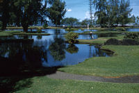
- Liliʻuokalani Park and Gardens
- Lyman Museum
- Mauna Loa Macadamia Nut Corporation
- Mokupāpapa Discovery Center for Northwestern Hawaii's remote coral reefs[13]
- Nani Mau Gardens
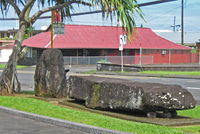
- Naha Stone (associated with Kamehameha I) in front of the Hilo Public Library
- Onomea Bay Scenic Drive
- Pacific Tsunami Museum
- Pana'ewa Rainforest Zoo
- Prince Kuhio Plaza
- Rainbow Falls (Waianuenue) & Boiling Pots on the Wailuku River
- University of Hawaiʻi at Hilo Botanical Gardens
- Wailoa River State Recreation Area with King Kamehameha Statue
Media
Hilo is served by the Hawaii Tribune-Herald, member of the Stephens Media Group.[14]
Sister city
- La Serena, Chile
- Nago, Okinawa, Japan
References
- ↑ "Find a County". National Association of Counties. http://www.naco.org/Template.cfm?Section=Find_a_County&Template=/cffiles/counties/usamap.cfm. Retrieved 2008-01-31.
- ↑ "Hilo CDP, Hawaii." U.S. Census Bureau. Retrieved on May 21, 2009.
- ↑ Ellis, W. A Narrative of an 1823 Tour through Hawai'i, republished 2004, Mutual Publishing, Honolulu ISBN 1-56647-605-4, chapters 11 and 12
- ↑ Jeane Branch Johnston (May 2003). "Personal Accounts from Survivors of the Hilo Tsunamis of 1946 and 1960: Toward a Disaster Communications Model". Master's Thesis. University of Hawaii. http://hdl.handle.net/10125/7104. Retrieved 2009-07-23.
- ↑ "US Gazetteer files: 2000 and 1990". United States Census Bureau. 2005-05-03. http://www.census.gov/geo/www/gazetteer/gazette.html. Retrieved 2008-01-31.
- ↑ 6.0 6.1 "NCDC: U.S. Climate Normals". National Oceanic and Atmospheric Administration. http://cdo.ncdc.noaa.gov/climatenormals/clim20/hi/511492.pdf. Retrieved 10 November 2009.
- ↑ Hilo, Hawaiʻi information on NOAA web site
- ↑ 8.0 8.1 "Monthly Averages for Hilo, HI". The Weather Channel. http://www.weather.com/outlook/health/achesandpains/wxclimatology/monthly/graph/USHI0022. Retrieved 2010-04-04.
- ↑ Record 24-hour rainfall on NOAA web site
- ↑ "Where is Hilo Hawai'i?". Frequently Asked Questions. The Pacific Tsunami Museum web site. http://www.tsunami.org/faq.html. Retrieved 2009-07-23.
- ↑ "Climatological Normals of Hilo". Hong Kong Observatory. http://www.hko.gov.hk/wxinfo/climat/world/eng/australia/pacific/hilo_e.htm. Retrieved 2010-05-12.
- ↑ "American FactFinder". United States Census Bureau. http://factfinder.census.gov. Retrieved 2008-01-31.
- ↑ "Education - Discovery Center". Papahānaumokuākea Marine National Monument web site. NOAA. http://papahanaumokuakea.gov/education/center.html. Retrieved 2009-08-25.
- ↑ "Hawaii Tribune-Herald". official web site. Stephens Media Group. http://www.hawaiitribune-herald.com/. Retrieved 2009-08-25.
External links
|
|||||||||||||||||

|
||||||||||||||||||||