Iğdır Province
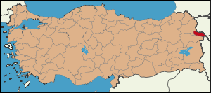
Iğdır is a province in eastern Turkey, located along the border with Armenia, Azerbaijan (the area of Nakhchivan), and Iran. Its adjacent provinces are Kars to the northwest and Ağrı to the west and south. It occupies an area of 3,587 km²[1] and population of 179,839 (2006 est.), it was 168,634 in 2000 (up from 142,601 in 1990).
Turkey's highest mountain, Mount Ararat (Ağrı Dağı) is in Iğdır, but much of the land is a wide plain far below the mountain. The climate is the warmest in this part of Turkey, cotton can be grown in Iğdır. Iğdır is where Noah is said to have thrived following the flood. The border with Armenia follows the Aras River.
The provincial capital is the city of Iğdır.
Districts
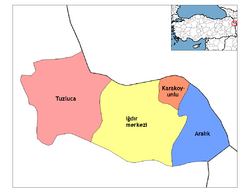
Iğdır province is divided into 4 districts (capital district in bold):
- Aralık
- Iğdır
- Karakoyunlu
- Tuzluca
Etymology
The area is named after a western Turkish clan Iğdıroğlu belonging to a branch of the Oghuz Turks. [2] They spread throughout Anatolia and there are towns and villages named Iğdır in Malatya and other parts of Turkey today.[3]
History
Archaeological research has uncovered Hurrian settlements in the Iğdır region going back to 4000 BC. The area was part of the Urartu kingdom circa 800 BC. There is a Urartu statuary in the area. It remained under Urartian control until its transition to the Median Empire, Persian Empire, Alexandros The Great, Orontid Dynasty of the Kingdom of Armenia. Seleucid, Parthian, Roman, Sassanid and Byzantine forces were prominent from the 4th century BC, followed by the Arab armies of Islam in 646. Turks, Georgians and Mongols fought through here for 400 years from 1064 onwards until the area was settled by Kara Koyunlu and then Ak Koyunlu Turkish tribes in the early 15th century.
A warfare ensued between Ottoman Empire and the Persian Empire from 1534 until 1746. In 1746, most of the land within the province of Iğdır today was ceded to Persia and became part of the Erivan khanate, a Muslim principality in Persia. The northern part of the province remained in Persian hands until after the Russo-Persian War, 1826-1828 when it became part of the Russian Empire under the Treaty of Turkmenchay. Under Russian administration, the area became the Surmalu uyezd (with its capital at the city of Iğdır) of the Armenian Oblast and later the Erivan Governorate. The southern half of the province remained in Ottoman hands through most of the 19th century but was also brought within the Russian Empire by Russo-Turkish War of 1877-78.
By the end of World War I, the whole area was under Russian control and Iğdır came under the administration of the Democratic Republic of Armenia as part of the Ararat province but upon the arrival of the newly founded Turkish army, Iğdır was ceded to Turkey by the Soviet Union in the Treaty of Kars. A substantial Armenian population remained in the area throughout this history of struggle between great powers. Armenians formed the ethnic majority in the city of Iğdır itself until 1919-1920 when most either died or fled due to starvation and Turkish–Armenian War.[4]
Demographics
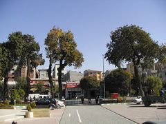
A street in Iğdır City
Today, Iğdır has a mixed population of Azeris and Kurds, both of whom compromise roughly half of the population, the former primarily inhabiting the north and east of the province and the latter inhabiting the south and west of the province. The spring festival Nevruz, the ancient pagan Iranian new year observed by Azeris and Kurds and other Turkic and Iranian people in general, is widely celebrated in Iğdır. The rural areas of Iğdır province have a higher population density (30 inhabitants/km²) than those of neighbouring provinces.
|
| Year |
People |
| 1927 |
34,840 |
| 1935 |
45,648 |
| 1940 |
46,669 |
| 1945 |
49,115 |
|
Year
|
People
|
| 1950 |
56,882 |
| 1955 |
70,951 |
| 1960 |
85,041 |
| 1965 |
96,652 |
|
Year
|
People
|
| 1970 |
112,256 |
| 1975 |
130,338 |
| 1980 |
127,438 |
| 1985 |
141,490 |
|
Year
|
People
|
| 1990 |
142,601 |
| 1997 |
145,411 |
| 2000 |
168,634 |
| 2007 |
181,866 |
|
Places of interest
- The caravanserai of Zor, believed to have been built by an Armenian architect in the 13th or 14th century, is located 35 km south-west of the city of Iğdır, and is named after the nearby village of Zor. It was one of halting places along the trade route between northern Persia and Georgia. Caravans used to stay over-here before passing over the Çilli pass. Restoration works have begun on the structure which has been put under protection since 1988.[5] The ruins of an Armenian church was once located in the same area, but today nothing remains of it.[6]
- Sürmeli castle, 25 km west of the city of Iğdır and on the road to Tuzluca, is the site of a medieval Armenian town. However, it is currently inaccessible due to border restrictions.
- Statues with Ram Heads, Cementer stones with ram heads existing almost in all old cementers in Iğdır Plain are remnants from Kara Koyunlu period. These cementers of brave, heroic persons and young persons who had died in youth age.[7]
- Aras Bird Research and Education Center, One of only four active bird research and banding (ringing) stations in Turkey. 204 bird species have been recorded so far in the wetlands along Aras River, Yukari Ciyrikli, Tuzluca. Bird enthusiasts can volunteer or visit to experience the diverse birdlife and traditional village life. From Kars to Igdir, turn immediately right 10 meter before the Aras bridge and drive 4 km to Yukari Ciyrikli village. [8]
References