Jamestown, Saint Helena
| Jamestown | |
|---|---|
 |
|
 |
|
| Coordinates: | |
| Country | United Kingdom |
| Administrative Area | Saint Helena |
| Area | |
| - Total | 1.4 sq mi (3.6 km2) |
| Population (2008) | |
| - Total | 714 |
| - Density | 513.6/sq mi (198.3/km2) |
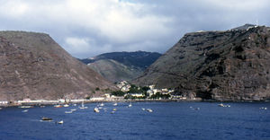
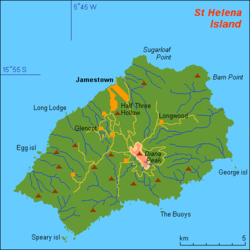
Jamestown is the capital of the island of Saint Helena, a British overseas territory in the South Atlantic Ocean. Located on the island's north-western coast, it is the island's port, with facilities for unloading goods delivered to the island, and the centre of the island's road and communications network. It has a population of 714 (2008 figures).[1]
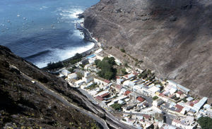
Jamestown was founded in 1659 by the East India Company and named after James, Duke of York, the future King James II of England. It is built on igneous rock in a small enclave, sandwiched between steep cliffs that are unsuitable for building. The town is therefore rather long, thin and densely populated, with tightly knit, long and winding streets. Shrubs and trees decorate some of the street corners. The surrounding terrain is rough and steep. The town's population has been shrinking, in line with the shrinking island population as a whole but also as a result of the growth of Jamestown's "suburb", Half Tree Hollow.
The town has some examples of British Georgian-era colonial architecture and is proposed as a UNESCO World Heritage Site. Many buildings are built out of local volcanic rock. St James' church dates from 1774 and is the oldest Anglican church in the Southern Hemisphere. Another of the town's prominent features is Jacob's Ladder, a staircase of 699 steps, built in 1829 to connect Jamestown to the former fort on Ladder Hill. The ladder is very popular with tourists, is lit at night and a timed run takes place there every year, with people coming from all over the world to take part.
Climate
Jamestown features an arid climate with essentially consistent temperatures throughout the year. Despite the fact that the city has an arid climate, its temperatures are moderated by the adjacent ocean. As a result, it seldom gets extremely hot in Jamestown. The temperature in the Jamestown area is some 5 degrees warmer than the rest of the island, because of the difference in altitude. The surrounding waters can be quite rough at times, and there is a sea wall to protect the settlement.
| Climate data for Jamestown | |||||||||||||
|---|---|---|---|---|---|---|---|---|---|---|---|---|---|
| Month | Jan | Feb | Mar | Apr | May | Jun | Jul | Aug | Sep | Oct | Nov | Dec | Year |
| Record high °C (°F) | 32 (90) |
32 (90) |
33 (91) |
34 (93) |
28 (82) |
27 (81) |
26 (79) |
26 (79) |
26 (79) |
26 (79) |
27 (81) |
28 (82) |
34 (93) |
| Average high °C (°F) | 27 (81) |
27 (81) |
28 (82) |
27 (81) |
24 (75) |
23 (73) |
22 (72) |
22 (72) |
22 (72) |
23 (73) |
23 (73) |
24 (75) |
24 (75) |
| Average low °C (°F) | 21 (70) |
21 (70) |
22 (72) |
21 (70) |
19 (66) |
18 (64) |
17 (63) |
17 (63) |
17 (63) |
18 (64) |
18 (64) |
19 (66) |
19 (66) |
| Record low °C (°F) | 17 (63) |
19 (66) |
19 (66) |
17 (63) |
16 (61) |
16 (61) |
14 (57) |
15 (59) |
14 (57) |
16 (61) |
17 (63) |
16 (61) |
14 (57) |
| Precipitation mm (inches) | 8 (0.31) |
10 (0.39) |
20 (0.79) |
10 (0.39) |
18 (0.71) |
18 (0.71) |
8 (0.31) |
10 (0.39) |
5 (0.2) |
3 (0.12) |
0 (0) |
3 (0.12) |
113 (4.45) |
| Source: BBC Weather [2] | |||||||||||||
References
- ↑ "Saint Helena Administrative Units". GeoHive. 2009. http://www.xist.org/cntry/sthelena.aspx. Retrieved 2009-04-07.
- ↑ "Average Conditions Jamestown, St Helena". BBC Weather. http://www.bbc.co.uk/weather/world/city_guides/results.shtml?tt=TT004840. Retrieved August 21, 2009.
External links
|
||||||||||||