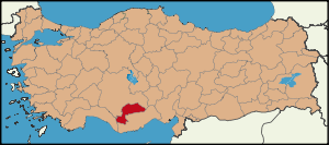
Karaman Province
| Location of Karaman Province in Turkey | |
|---|---|
 |
|
| Overview | |
| Region: | Central Anatolia Region, Turkey |
| Area: | 9,163 km2 (3,538 sq mi) |
| Total Population | 252,377 TurkStat 2007 (est) |
| Population density | 27.59 /km2 (71.5 /sq mi) |
| Licence plate code: | 70 |
| Area code: | 0338 |
| Governor Website | http://www.karaman.gov.tr |
Karaman is a province of central Turkey. It has an area of 9,163 km². It has a population of 252,377 (2006 est). According to the 2000 census the population was 243,210. Population density is 27.54 people/km². The traffic code is 70. The capital is the city of Karaman. Karaman was the location of the Karamanid emirate, which came to an end in 1486.
Contents |
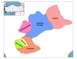
Districts
Karaman province is divided into 6 districts (capital district in bold):
- Ayrancı
- Başyayla
- Ermenek
- Karaman
- Kazımkarabekir
- Sarıveliler
See also
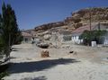
- Görmeli, a village on the hillside of Taurus Mountains near Ermenek.
- Karadag, Karaman, a volcano north of Karaman city.
Gallery
 Görmeli, a village in Ermenek district |
 Akpınar village in Ayrancı district |
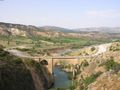 View of Ala Bridge near Ermenek |
External links
- (Turkish) Karaman governor's official website
- (Turkish) Karaman municipality's official website
- (English) Karaman weather forecast information
See also
- Karaman Province, Ottoman Empire
|
||||||||||||||||||||||||||||||||||
|
|||||||
| This article about a Central Anatolia Region of Turkey location is a stub. You can help Wikipedia by expanding it. |