Kilis Province
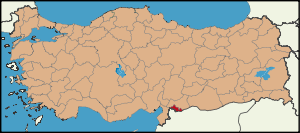
| Location of Kilis Province in Turkey | |
|---|---|
 |
|
| Overview | |
| Region: | Mediterranean Region, Turkey |
| Area: | 1,642 km2 (634 sq mi) |
| Total Population | 118,457 TurkStat 2007 (est) |
| Licence plate code: | 79 |
| Area code: | 0348 |
| Governor Website | http://www.kilis.gov.tr |
Kilis is a province in south-central Turkey. It used to be the southern part of the province of Gaziantep and was formed in 1994. The town of Kilis is home to around 67% of the inhabitants of the province, the other towns and villages are very small.
Contents |
History
There is evidence of human occupation from 4,000 years ago, in the Middle Bronze Age. The region has been ruled by the Hurrians, the Assyrian Empire, the Hittite Empire, the Persian Empire, the Macedonian Empire, the Roman Empire (including the Byzantine Empire), and finally by Ottoman Empire.
Places of historical interest include a number of burial mounds, castles and mosques.
Geography
Kilis is located in the southern foothills of the Taurus Mountains west of the Euphrates River on the northern edge of the Syria Plain. The district contains areas of good agricultural land, watered by small rivers and 68% of the land area of Kilis is planted. Almost 4% of Turkey's grape production comes from Kilis. Other important agricultural products are olives, fruit, wheat, barley and tobacco. A Mediterranean climate dominates over the region, which is around 60 to 80 km away from the sea. Winters are cool and rainy, spring and fall months warm, and summers are hot. Average winter temperatures are 4 to 7 degrees Celsius, while in summer the temperatures do not fall under 25 degrees Celsius.
There is a border crossing into Syria, from where the road goes south to the Syrian city of Aleppo.
Kilis is traversed by the northeasterly line of equal latitude and longitude.
Prominent citizens
- Former chief-of-staff General Doğan Güreş was later Member of Parliament for Kilis.
- Army general Izettin Iyigün born in Kilis 1938
- Columnist and beauty contest judge Hıncal Uluç born Kilis 1939
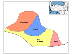
Districts
Kilis province is divided into 4 districts (capital district in bold):
- Elbeyli
- Kilis
- Musabeyli
- Polateli
References
- Turkish Statistical Institute. "TÜİK 2007 estimates for Kilis". http://tuikrapor.tuik.gov.tr/reports/rwservlet?adnks=&report=turkiye_il_koy_sehir.RDF&p_il1=79&p_kod=2&desformat=html&ENVID=adnksEnv. Retrieved 2009-10-09.
External links
- (Turkish) Kilis governor's official website
- (Turkish) Kilis municipality's official website
- (English) Kilis weather forecast information
|
||||||||||||||||||||||||||||||||||
|
|||||||
| This article about a Southeastern Anatolia Region of Turkey location is a stub. You can help Wikipedia by expanding it. |