Lowell, Massachusetts
| City of Lowell | |||
|---|---|---|---|
| — City — | |||
 |
|||
|
|||
| Nickname(s): Mill City, Spindle City | |||
| Motto: Art is the Handmaid of Human Good | |||
 |
|||
| Coordinates: | |||
| Country | United States | ||
| State | Massachusetts | ||
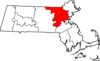
| County | Middlesex | ||
| Settled | 1653 | ||
| Incorporated | 1826 | ||
| A city | 1836 | ||
| Government | |||
| - Type | Manager-City council | ||
| - Mayor | Bud. C. Caulfield | ||
| - City Manager | Bernard F. Lynch | ||
| Area | |||
| - Total | 14.5 sq mi (37.7 km2) | ||
| - Land | 13.8 sq mi (35.7 km2) | ||
| - Water | 0.8 sq mi (2.0 km2) | ||
| Elevation | 102 ft (31 m) | ||
| Population (2007) | |||
| - Total | 103,512 | ||
| - Density | 7,500.9/sq mi (2,899.5/km2) | ||
| Time zone | Eastern (UTC-5) | ||
| - Summer (DST) | Eastern (UTC-4) | ||
| ZIP code | 01850, 01851, 01852, 01853, 01854 | ||
| Area code(s) | 978 / 351 | ||
| FIPS code | 25-37000 | ||
| GNIS feature ID | 0611832 | ||
| Website | http://www.lowellma.gov/ | ||

Lowell is a city in Middlesex County, Massachusetts, USA. As of the 2000 census, the city had a total population of 105,167. It is the fifth largest city in the state. Lowell and Cambridge are the county seats of Middlesex County.[1]
History

Founded in the 1820s as a planned manufacturing center for textiles, Lowell is located along the rapids of the Merrimack River, 30 miles northwest of Boston in what was once the farming community of East Chelmsford, Massachusetts. The so-called Boston Associates, including Nathan Appleton and Patrick Tracy Jackson of the Boston Manufacturing Company, named the new mill town after their visionary leader, Francis Cabot Lowell, who had died five years before its 1823 incorporation. As Lowell's population grew, it acquired more land from neighboring towns, and diversified into a full-fledged urban center, with many of canal & factory construction labor force immigrating from Ireland, escaping the Potato Famines of the 1830s & 1840s, as well as, the mill workers or Mill Girls coming from the farms of New England. By the 1850s it was the largest industrial complex in the United States. In 1860, there were more cotton spindles in Lowell than in all eleven states that would form the Confederacy combined.[2] The city continued to thrive as a major industrial center during the 19th century, attracting more migrant workers and immigrants to its mills. Next were the Catholic Germans, then a large influx of French Canadians during the 1870s & 1880s, then other waves of immigrants, such as, Portuguese, Polish, Lithuanians Swedes, and Jews came to work in Lowell and settled their own neighborhoods, with the cities' population reaching almost 50% foreign-born by 1900.[3] By the time World War I broke out in Europe, the city had reached its economic and population peak of over 110,000 people.
With the decline of the Mill Cities' manufacturing base, with many companies moving to the South in the 1920s,[3] the city fell into deep hard times, and was called a "depressed industrial desert" by Harper's Magazine in 1931, and over a third of its population was "on relief" as only three of its major textile corporations remained active.[3] A few short years later, the mills were reactivated, making parachutes and other military necessities for the War effort. However, this economic boost was short-lived and the post-war years saw the last textile plants close. Over the next few decades the city was just a shadow of itself, until the 1970s, when Lowell became part of the Massachusetts Miracle, being the headquarters of Wang Laboratories. At the same time, Lowell became home to thousands of new immigrants, many from Cambodia, following the genocide at the hands of the Khmer Rouge. The city continued to rebound, but this time, focusing more on culture. The former mill district along the river was partially restored and became part of the Lowell National Historical Park, founded in the late 1970s. Even though Wang went bankrupt in 1992, the city continued its cultural focus by hosting the nations largest free folk festival, Lowell Folk Festival, as well as many other cultural events. This effort began to attract other companies and families back to the urban center with other historic manufacturing and commercial buildings being repurposed as residential units and office space. By the 1990s, Lowell built a new ballpark and arena, which became home to two minor league sports teams, the Lowell Devils and Lowell Spinners. The city also began to include a larger student presence as well, through expansions of the University of Massachusetts Lowell and Middlesex Community College.
Geography
Lowell is located at (42.639444, -71.314722).[4] According to the United States Census Bureau, the city has a total area of 14.5 square miles (37.7 km²).13.8 square miles (35.7 km²) of it is land and 0.8 square miles (2.0 km²) of it (5.23%) is water.
Physical
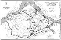
Lowell is located at the confluence of the Merrimack and Concord Rivers. The Pawtucket Falls, a mile-long set of rapids with a total loss in elevation of 32 feet, ends where the two rivers meet. At the top of the falls is the Pawtucket Dam - designed to turn the upper Merrimack into a millpond, diverted through Lowell's extensive canal system.
The Merrimack, which flows southerly from Franklin, New Hampshire to Lowell, makes a northeasterly turn there before emptying into the Atlantic Ocean at Newburyport, Massachusetts, approximately 40 miles downriver from Lowell. It is believed that in prior ages, the Merrimack continued south from Lowell to empty into the ocean somewhere near Boston. The glacial deposits that redirected the flow of the river are also responsible for the drumlins that dot the city, most notably, Fort Hill in the Belvidere neighborhood. Other large hills in Lowell include Lynde Hill, also in Belvidere, and Christian Hill, in the easternmost part of Centralville.
The Concord, or Musketaquid (its original name), forms from the confluence of the Assabet and Sudbury Rivers at Concord, Massachusetts. This river flows north into the city, and the area around the confluence with the Merrimack was known as Wamesit. Like the Merrimack, the Concord, although a much smaller river, has many waterfalls and rapids that served as power sources for early industrial purposes, some well before the founding of Lowell. Immediately after the Concord joins the Merrimack, the Merrimack descends another ten feet in Hunt's Falls.
There is a ninety-degree bend in the Merrimack partway down the Pawtucket Falls. At this point, the river briefly widens and shallows. Here, Beaver Brook enters from the north, separating the City's two northern neighborhoods - Pawtucktville and Centralville. Entering the Concord River from the southwest is River Meadow, or Hale's Brook. This brook flows largely in a man-made channel, as the Lowell Connector was built along it. Both of these minor streams have limited industrial histories as well.
The bordering towns (clockwise from north) are Dracut, Tewksbury, Billerica, Chelmsford, and Tyngsboro. The border with Billerica is a point in the middle of the Concord River where Lowell and Billerica meet Tewksbury and Chelmsford.
The ten communities designated part of the Lowell Metropolitan area by the 2000 US Census are Billerica, Chelmsford, Dracut, Dunstable, Groton, Lowell, Pepperell, Tewksbury, Tyngsboro, and Westford, and Pelham, NH. See Greater Lowell.
Lowell received an "All-America City" award in 1999, and was a finalist in 1997 and 1998.[5]
Neighborhoods
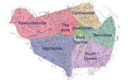
Lowell currently has eight distinct neighborhoods; the Acre, Back Central, Belvidere, Centralville, Downtown, Highlands, Pawtucketville, and South Lowell.[6] The City also has 5 zip codes, 4 are geographically distinct general zip codes and 1 is for PO-boxes only (01853).
The Centralville neighborhood, zip code 01850, is the northeastern section of the city, north of the Merrimack River and east of Beaver Brook. Christian Hill is the section of Centralville, located east of Bridge Street.
The Highlands is the most populated neighborhood with almost a quarter of the city residing here, zip code 01851, and is the southwestern section of the city, bordered to the east by the Lowell Connector and to the north by the railroad. Lowellians further distinguish the sections of the Highlands as the Upper Highlands and the Lower Highlands referring to the area closer to downtown. Middlesex Village, Tyler Park and Drum Hill are in this zip code.
Belvidere, Back Central and South Lowell make up the 01852 zip code, and are the southeastern sections of the city (south of the Merrimack River and south east of the Lowell Connector). Belvidere is the mostly residential area south of the Merrimack River, east of the Concord River and north of the Lowell and Lawrence railroad. Belvidere Hill is an Historic District along Fairmount St. Lower Belvidere refers to the section west of Nesmith Street. Back Central is an urban area south of downtown towards the mouth of River Meadow Brook. South Lowell is the area south of the railroad and east of the Concord River. Other neighborhoods in this zip code are Ayers City, Bleachery, Chapel Hill, the Grove, Oaklands, Riverside Park, Swede Village and Wigginsville, but their use is mostly antiquated
The zip code 01854 is the northwestern portion of the city and includes Pawtucketville, the University of Massachusetts, Lowell and the Acre. Pawtucketville is where famous writer Jack Kerouac resided around the area of University Ave (previously known as Moody st.). North campus of UMASS Lowell is located in Pawtucketville. The older parts of the neighborhood are located around University Ave. and Mammoth Road whereas the newer parts are located around Varnum Ave. Middle and elementary schools for this area include Wang Middle School, Pawtucketville Memorial, Mccavinue elementary school and private school St. Jeanne D'arc. Pawtucketville is the official entrance to the Lowell-Dracut-Tyngsboro State Forest. Pawtucketville's Lowell-Dracut-Tyngsborough State Forest is the probable site of a notable Native American tribe, and in age of the Industrial Revolution was a prominent source where granite for canals and factory foundations were obtained.[7]
Demographics
| Historical populations | |||
|---|---|---|---|
| Census | Pop. | %± | |
| 1830 | 6,474 |
|
|
| 1840 | 20,796 | 221.2% | |
| 1850 | 33,383 | 60.5% | |
| 1860 | 36,827 | 10.3% | |
| 1870 | 40,928 | 11.1% | |
| 1880 | 59,475 | 45.3% | |
| 1890 | 77,696 | 30.6% | |
| 1900 | 94,969 | 22.2% | |
| 1910 | 106,294 | 11.9% | |
| 1920 | 112,759 | 6.1% | |
| 1930 | 100,234 | −11.1% | |
| 1940 | 101,389 | 1.2% | |
| 1950 | 97,249 | −4.1% | |
| 1960 | 92,107 | −5.3% | |
| 1970 | 94,239 | 2.3% | |
| 1980 | 92,418 | −1.9% | |
| 1990 | 103,439 | 11.9% | |
| 2000 | 105,167 | 1.7% | |
According to the 2000 Census[8], there were 105,167 people residing in the city. The population density was 7,635.6 people per square mile (2,948.8/km²). There were 39,468 housing units at an average density of 2,865.5/sq mi (1,106.7/km²). The racial makeup of the city was;
- 68.60% White (U.S. Average: 75.1%)
- 16.52% Asian American (U.S. Average: 3.6%)
- 4.21% African American (U.S. Average: 12.3%)
- 0.24% Native American (U.S. Average: 0.1%)
- 0.04% Pacific Islander (U.S. Average: 0.1%)
- 6.48% from other races (U.S. Average: 5.5%)
- 3.92% from two or more races. (U.S. Average: 2.4%)
Hispanic or Latino of any race were 14.01% of the population. (U.S. Average: 12.5%)
Lowell had the highest percentage of Cambodians of any place in the United States, with 10.37% of its population being Cambodian,[9] and is only second in population to Long Beach, California. There are an estimated 11,000 Cambodians living in the city of Lowell, but local community leaders estimate the number to be around 35,000.[10] The Government of Cambodia had opened up its third U.S. Consular Office in Lowell, on April 27, 2009, with Sovann Ou as current advisor to the Cambodian Embassy.[11] The other two are in Seattle and Long Beach.
In 2000, there were 37,887 households, and 23,982 families living in Lowell; with the average household size was 2.67 and the average family size was 3.35.
- 34.0% had children under the age of 18 living with them.(U.S. Average: 32.8%)
- 40.1% were married couples living together. (U.S. Average: 51.7%)
- 17.4% had a female householder with no husband present. (U.S. Average: 12.2%)
- 36.7% were non-families. (U.S. Average: 31.9%)
- 29.0% of all households were made up of individuals.(U.S. Average: 25.8%)
- 9.3% had someone living alone who was 65 years of age or older. (U.S. Average: 9.2%)
In 2000, the city's population had a median age of 31 (U.S. Average: 35.3).
- 26.9% under the age of 18
- 11.9% from 18 to 24.
- 32.5% from 25 to 44
- 17.9% from 45 to 64
- 10.8% who were 65 years of age or older.
For every 100 females there were 97.1 males. For every 100 females age 18 and over, there were 94.1 males.
The median income for a household in the city was $39,192 (U.S. Average: $41,994). The median income for a family was $45,901. (U.S. Average: $50,046) Males had a median income of $33,554 versus $27,399 for females. The per capita income for the city was $17,557. About 13.6% of families (U.S. Average: 9.2%) and 16.8% of individuals (U.S. Average: 12.4%) were below the poverty line, including 23.2% of those under age 18 and 14.0% of those age 65 or over.
Government
| Lowell City Council 2010-2011[12] |
|---|
|
Lowell has a "Plan E form" Council-manager government. There are nine city councilors and six school committee members, all elected at large in a non-partisan election. The City Council chooses one of its members as mayor, and another as vice-mayor; the mayor serves as chair of the council, serves as the seventh member of the school committee, and performs certain ceremonial duties. The administrative head of the city government is the City Manager, who is responsible for all day-to-day operations, functioning within the guidelines of City Council policy, and is hired by and serves at the pleasure of the City Council as whole. As of January 2010, the City Manager is Bernard F. Lynch and James L. Milinazzo is the Mayor.
As of August 2005, Lowell became part of one Massachusetts Senate district.
| Voter Registration and Party Enrollment as of October 15, 2008[13] | |||||
|---|---|---|---|---|---|
| Party | Number of Voters | Percentage | |||
| Democratic | 21,505 | 41.37% | |||
| Republican | 4,877 | 9.38% | |||
| Unaffiliated | 25,083 | 48.25% | |||
| Minor Parties | 523 | 1.01% | |||
| Total | 51,988 | 100% | |||
State Representatives
Lowell's State Representatives are currently
- Sixteenth Middlesex, represented by Thomas A. Golden,Jr.(D)
- Seventeenth Middlesex, represented by David M. Nangle (D)
- Eighteenth Middlesex, represented by Kevin J. Murphy (D))
The two U.S. Senators from Massachusetts, representing at large, are John Kerry (D) and Scott Brown (R).
==
Massachusetts General Court
In the Massachusetts General Court Lowell's State Senator to the Massachusetts Senate is currently:
- First Middlesex, represented by Steven C. Panagiotakos
United States Congress
The City of Lowell is part of the Massachusetts Fifth Congressional District, represented by Niki Tsongas (D), as well as the Third Governor's Council District represented by Marilyn Petitto Devaney.kos]] (D)
Transportation
Lowell can be reached by automobile from Interstate 495, US Route 3, the Lowell Connector, and Massachusetts Routes 3A, 38, 110, 113, and 133.[14]
For public transit, Lowell is served by the Lowell Regional Transit Authority, which provides fixed route bus services and paratransit services to the city and surrounding area. These connect at the Gallagher Transit Terminal to the Lowell Line of the MBTA commuter rail system, which connects Lowell to Boston. The terminal is also served by several intercity bus lines.[14]
The Lowell National Historical Park provides a free streetcar shuttle between its various sites in the city center, using track formerly used to provide freight access to the city's mills.
Media
Newspapers
- The Sun (Lowell) - Daily Newspaper
Radio
- WCAP AM 980, talk radio
- WUML FM 91.5, UMass Lowell-owned station
Points of interest
Among the many tourist attractions, Lowell also currently has 39 places on the National Register of Historic Places including many buildings and structures as part of the Lowell National Historical Park.
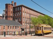
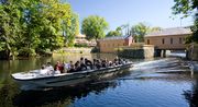
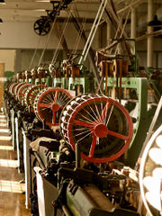
- Lowell National Historical Park: Maintains Lowell's history as an early manufacturing and immigrant city. Exhibits include weave rooms, a waterpower exhibit, and paths along 5.6 miles of largely restored canals.
- Lowell-Dracut-Tyngsboro State Forest: Hiking, biking, and cross-country skiing trails in an urban state forest
- University of Massachusetts Lowell: State university
- Vandenberg Esplanade: Walking, biking, swimming, and picnicking park along the banks of the Merrimack River. Contains the Sampas Pavilion.
- Lowell High School: The first desegregated and co-educational high school in the United States
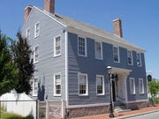
- Jack Kerouac's birthplace: In the Centralville section of the city at 9 Lupine Road.
- Bette Davis's birthplace: In the Highlands section of the city at 22 Chester Street.
- Edson Cemetery: burial site of Jack Kerouac, John McFarland, Passaconaway and William Preston Phelps. 1375 Gorham Street.
- The Worthen House: Edgar Allan Poe purportedly visited this tavern and local lore suggests he wrote some of "The Raven" here.
- The Acre: Lowell's gateway neighborhood where waves of immigrants have established their communities
- University of Massachusetts Lowell Radiation Laboratory: The site of a small nuclear reactor at the school
- Yorick Building: Former home of the gentlemen's club the "Yorick Club", currently a restaurant & function facility.
Culture
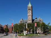
In the early years of 1840's when the population quickly exceeded 20,000, Lowell became very active as a cultural center, with the construction of the Lowell Museum, the Mechanics' Hall, as well as, the new City Hall used for art exhibits, lectures, and for the performing arts. The Lowell Museum was lost in a devastating fire in the early morning of January 31, 1856,[15] but was quickly rehoused in a new location. The Lowell Art Association was founded in 1876, and the new Opera House was built in 1889.[16]
Continuing to inspire and entertain, Lowell currently has a plethora of artistic exhibitions and performances throughout a wide range of venues in the city:
Museums and public galleries
- 119 Gallery
- The American Textile History Museum[17]
- Ayer Lofts Artist Live-work Lofts
- The Boott Cotton Mills Museum: Lowell National Historic Park
- Brush Art Gallery and Studios
- The New England Quilt Museum
- National Streetcar Museum[18]
- Patrick J. Morgan Cultural Center: Lowell National Historic Park
- The Revolving Museum "Making Space for Art and Community."
- Whistler House Museum of Art - Art museum in birthplace of James McNeill Whistler.
- Western Avenue Studios - A converted mill with over 160 working artists and musicians.
Interactive and live performances
- Arts League of Lowell
- Angkor Dance Troupe - Cambodian classical and folk dance company and youth program[19]
- Center for Lowell History, University of Massachusetts Lowell - local history library and archive
- Lowell Memorial Auditorium - Mid-sized venue for live performances.
- Lowell Summer Music Series - Boarding House Park
- Lowell Rocks - Lowell nightlife and entertainment web site
- Lowell Telecommunication Corporation (LTC) - A community media and technology center
- Merrimack Repertory Theater - Professional equity theater
- Play by Player's Theatre Company - critically acclaimed community theater
- Lowell Philharmonic Orchestra - Community orchestra presenting free concerts and offering youth programs
- RRRecords - Internationally known record label and store
- Standing Room Only Players - musical review troupe
- The Gentlemen Songsters The Lowell Chapter of The Barbershop Harmony Society -Causing Harmony In The Merrimack Valley.
- Lowell Poetry Network - A network of area poets and appreciators of poetry who host readings, receptions, and open mics.
- U-Mass Lowell Music Performances
- The United Teen Equality Center A by teens, for teens youth center promoting peace, positivity and empowerment for young people in Lowell.
Sports
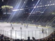
On April 1, 2006, Lowell held the 2006 World Curling Championships for the men's teams at the Tsongas Center at UMass Lowell.
- University of Massachusetts Lowell River Hawks, NCAA Division I Hockey, and Division II Soccer, Basketball, Baseball, Softball, Track & Field, Cross Country, Volleyball
- Lowell Spinners - Class A short-season professional baseball affiliate of the Boston Red Sox
- Lowell All-Americans - NECBL (Collegiate Summer Baseball)
- New England Riptide - National Pro Fastpitch League (Major League Softball)
- Lowell Nor'easter - Semi-Professional football team (New England Football League)
Venues
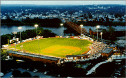
- Edward A. LeLacheur Park Baseball Stadium, shared by Lowell Spinners and the University of Massachusetts Lowell
- Lowell Memorial Auditorium - performance and boxing venue.
- Tsongas Center at UMass Lowell - multi-use sports and concert venue (6500 seats hockey, 7800 concerts)- the University of Massachusetts Lowell River Hawks, and various arena shows
- Cawley Memorial Stadium- Stadium for Lowell High School and other sporting events around the Merrimack Valley. Uses FieldTurf
- Sampas Pavilion - Outdoor amphitheater on the banks of the Merrimack River
- Stoklosa Alumni Field - Baseball stadium, used by Lowell All-Americans (4,000 seats)
Annual events
- FEB: Winterfest - celebration of winter.
- MAY: Doors Open Lowell a celebration of preservation, architecture, and design where many historic buildings that normally have limited public access are open for viewing
- JUNE: African Festival - A celebration of the various African communities in and around Lowell
- JULY: Lowell Folk Festival - three day free folk festival attended by on average 250,000 people on the last weekend in July
- AUG: Lowell Southeast Asian Water Festival - celebrates Southeast Asian culture
- OCT: The Massachusetts Poetry Festival - an event that celebrates poets and poetry in the Commonwealth of Massachusetts.
- OCT: Bay State Marathon - October marathon and half marathon
Businesses started and/or products invented in Lowell
- CVS/pharmacy
- Moxie - the first mass-produced soft drink in the U.S.
- Father John's Medicine[20]
- Wang Laboratories - Massachusetts Miracle computer company
- Telephone numbers, 1879, Lowell is the first U.S. city to have phone numbers, two years after Alexander Graham Bell demonstrates his telephone in Lowell.[21]
- Francis Turbine - A highly efficient water-powered turbine
- Market Basket - Chain of approximately 60 grocery stores in Massachusetts and New Hampshire
- Cash Carriers
- Fred C. Church Insurance (est. 1865)[22]
- Stuart's Department Stores
Hospitals
- Lowell General Hospital
- Saints Medical Center
Education
Lowell Schools
High Schools
- Lowell High School, est. 1831 (4,000+ Students, second largest in the state)
- Lowell Catholic High School, est. 1989 (369 Students) Teacher/Student Ratio 1:10 (Private)
- Greater Lowell Technical High School, (2100 Students) Serving the communities of Lowell, Dracut, Tyngsborough and Dunstable.[23]
- Lowell Middlesex Academy Charter School, est.1996 (120 Students) serving the communities of Greater Lowell[24].
Grades 5-8
- Benjamin F. Butler Middle School, est. 1992 (500 Students) Teacher/Student Ratio N/A
- Dr. An Wang Middle School, est. 1993 (620 Students) Teacher/Student Ratio 1:29
- H.J. Robinson Middle School, est. 1969 (660 Students) Teacher/Student Ratio 1:25
- James S. Daley Middle School, est. 1956 (600 Students) Teacher/Student Ratio 1:24
- Kathryn P. Stoklosa Middle School, est. 2005 (485 Students) Teacher/Student Ratio 1:25
- James F. Sullivan Middle School of Communications, est. 1992 (586 Students) Teacher/Student Ratio 1:30
- Edith Nourse Rogers Middle School (Closed in 2009)
Grades K-8
- J. G. Pyne Arts Magnet (500 Students) [26]
- Bartlett Community Partnership School (460 Students) est. 2005[27]
- Lowell Community Charter Public School est. 1999[28]
Grades K-4
- Abraham Lincoln Elementary School, est. 1993 (505 Students) Teacher/Student Ratio 1:24
- Charlotte M. Murkland Elementary School, est. 1993 (460 Students) Teacher/Student Ratio 1:23
- Greenhalge Elementary School, re-est. 1994 (450 Students) Teacher/Student Ratio 1:20
- Pawtucketville Memorial Elementary School, est. 1990 (493 Students) Teacher/Student Ratio N/A
- S. Christa McAuliffe Elementary School, est. 1993 (500 Students) Teacher/Student Ratio N/A
- John J. Shaughnessy Elementary School, est. 1991 (500 Students) Teacher/Student Ratio 1:22
- Washington Elementary School, (220 Students) Teacher/Student Ratio 1:19
- C.W. Morey Elementary School, (420 Students) Teacher/Student Ratio 1:21
- Dr. Gertrude M. Bailey Elementary School, est. 1992 (460 Students) Teacher/Student Ratio 1:21
- Joseph A. McAvinnue Elementary School, est. 1994 (489 Students) Teacher/Student Ratio 1:24
- Moody Elementary School, est. 1841 (187 Students) Teacher/Student Ratio 1:28
- Peter W. Reilly Elementary School, est. 1959 (530 Students) Teacher/Student Ratio 1:21
Private Grade Schools
- Hellenic American Academy, est. 1908 as the first Greek Orthodox day school in the United States (135 Students) (Grades K-6) Teacher/Student Ratio 1:12[30]
- Franco-American School, est. 1963 (Grades K-8) Teacher/Student Ratio 1:13[31]
- St. Louis School, (457 Students) (Grades K-8) Teacher/Student Ratio 1:19
- Ste. Jeanne D'Arc School, (472 Students) (Grades K-8) Teacher/Student Ratio 1:17
- St. Margaret School, (357 Students) (Grade K-8) Teacher/Student Ratio 1:20
- St. Patrick School, (181 Students) (Grade K-8) Teacher/Student Ratio 1:15
- St. Michael Elementary School, (407 Students) (Grade K-8) Teacher/Student Ratio 1:16
- Immaculate Conception School, (324 Students) (Grade K-8) Teacher/Student Ratio 1:17
- St. Stanislaus School, est. 1906 (124 Students) (Grade K-8) Teacher/Student Ratio 1:12[32]
- Community Christian Academy, (185 Students) (Grade K-12) Teacher/Student Ratio 1:9
- Riverside School, Nonsectarian, Special Education School (25 Students) (Grades 4-11) Teacher/Student Ratio 1:5
Higher education
- University of Massachusetts Lowell
- Middlesex Community College
Crime
The city of Lowell is primarily policed and protected by the Lowell Police Department and secondarily by the Massachusetts State Police.
Since 1990, Lowell has averaged about 5 homicides per year with the highest being 13 homicides in 2006. As of 2008, the crime index rating was 446.8. The national average was 320.9. Lowell has been locally notorious over the years for being a place of high drug trafficking and gang activity. The Lowell Police Department has made positive progress in bringing the crime rates down in recent years. In the years from 1994 to 1999, crime dropped 50 percent, the highest rate of decrease for any city in America with over 100,000 residents.[33] In 2009, Lowell was ranked as the 139th most dangerous city of over 75,000 residents in the United States, out of 393 communities. Out of Massachusetts cities, nine are larger than 75,000 residents, and Lowell was fifth most dangerous or safest.[34] For comparison Lowell is rated safer than Boston (104 of 393), Providence RI (123), Springfield (51), Lynn (120), Fall River (103), and New Bedford (85), but rated more dangerous than Cambridge (303) , Newton (388), Quincy (312), and Worcester (175).[34]
References to Lowell
Music
The city is the subject of Death Cab for Cutie's song, "Lowell, MA," from their album We Have the Facts and We're Voting Yes
The city was also featured in the song "Lowell Man" by Tom Doyle. Doyle, of WROR-FM 105.7 in Boston, does many songs like this spoofing classic rock by rewording them to make fun of various things about New England (Lowell Man is a spoof of Soul Man by Sam & Dave).
The Dropkick Murphys' Warrior's Code tells story of Lowell Boxer Micky Ward, mentioning Lowell and several city facts in the song.
Novels
Lowell has also been the subject of a number of novels. Some of the better known ones are:
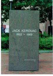
- Jack Kerouac, who was born in Lowell, set several biographical novels there, including Visions of Gerard and Doctor Sax.
- Katherine Paterson's novel Lyddie tells the fictional story of a Lowell Mill Girl in the nineteenth century who fights for better working conditions in the hot, crowded and dangerous mills.
- In Avi's Beyond the Western Sea: Lord Kirkle's Money, Lowell is the destination of immigrants hoping to reach America and begin new lives.
- Nancy Zaroulis' Call The Darkness Light, a novel about a young woman left alone in the world following the death of her father, tells the story of the mid-19th century Lowell Mill Girls and the realities of the textile industry.
- David Daniel's series of Alex Rasmussen novels follows the Lowell based private eye's adventures in books including The Marble Kite, and Goofy Foot.
- Lloyd L. Corricelli's Ronan Marino Mystery Series which includesTwo Redheads & A Dead Blonde, which follows the Iraqi war veteran and private investigator's quest to find his girlfriend's murderer and Chasing Curves where Ronan tries to clear a UMass-Lowell baseball star accused of murdering his prospective agent's secretary.
Films
- School Ties - 1992: A Robert Mandel’s film starring Brendan Fraser, Matt Damon, Chris O’Donnell, Randall Batinkoff, & Andrew Lowery. Some of the opening scenes were filmed in Lowell.
- High on Crack Street - 1995: An HBO film documenting the lives of three crack cocaine addicts.
- Monkey Dance - 2004: Documentary film by Julie Mallozzi on the lives of three Cambodian-American teenage adolescents in Lowell and how they were affected positively by traditional Cambodian dance, especially with Lowell's Angkor Dance Troupe.
- The Invention of Lying - 2009: A film by director/writer/star Ricky Gervais was filmed principally in Lowell. The film also stars Jennifer Garner, Rob Lowe, and Tina Fey.
- The Fighter - A new film by director David O. Russell starring Mark Wahlberg based upon the life of Irish Mickey Ward. Shooting began July 2009 and was completed in September of that year in Lowell, Massachusetts.
Notable residents
See List of People from Lowell, Massachusetts
References
- ↑ "Find a County". National Association of Counties. http://www.naco.org/Template.cfm?Section=Find_a_County&Template=/cffiles/counties/usamap.cfm. Retrieved 2008-01-31.
- ↑ Menand, Louis (2001), The Metaphysical Club: A Story of Ideas in America, New York: Farrar, Straus and Giroux, p. 10, ISBN 0-374-52849-7.
- ↑ 3.0 3.1 3.2 Marion, Paul, "Timeline of Lowell History From 1600s to 2009", Yankee magazine, November 2009.
- ↑ "US Gazetteer files: 2000 and 1990". United States Census Bureau. 2005-05-03. http://www.census.gov/geo/www/gazetteer/gazette.html. Retrieved 2008-01-31.
- ↑ [1]
- ↑ Lowell's Neighborhoods
- ↑ http://www.mass.gov/dcr/parks/northeast/ldtf.htm
- ↑ "American FactFinder". United States Census Bureau. http://factfinder.census.gov. Retrieved 2008-01-31.
- ↑ Cambodian ancestry by city - ePodunk
- ↑ [2]
- ↑ http://khmerization.blogspot.com/2009/04/cambodian-consulate-opens-in-lowell.html
- ↑ http://www.lowellma.gov/govt
- ↑ "Registration and Party Enrollment Statistics as of October 15, 2008" (PDF). Massachusetts Elections Division. http://www.sec.state.ma.us/ele/elepdf/st_county_town_enroll_breakdown_08.pdf. Retrieved 2010-05-08.
- ↑ 14.0 14.1 "City of Lowell - Location". http://www.Lowellma.gov/depts/dpd/services/econdev/Location. Retrieved 2007-10-02.
- ↑ "New York Times" article "Destruction of the Lowell Museum by Fire" January 31, 1856
- ↑ http://ecommunity.uml.edu/lhs/lowell_history.htm
- ↑ http://www.athm.org/
- ↑ http://www.trolleymuseum.org/lowell/
- ↑ Tuttle, Nancye, "Cambodian art, a New England tradition", The Lowell Sun, May 15, 2008.
- ↑ http://library.uml.edu/clh/Fath/Fath2.Html
- ↑ http://www.yankeemagazine.com/issues/2009-11/features/lowell-timeline
- ↑ http://fredcchurch.com/about/history.php?PHPSESSID=a70f3f4ae8d2dc644ec8e08f6b2a808c
- ↑ http://www.gltech.org/
- ↑ http://www.lmacs.org/qa/faq.html
- ↑ 25.0 25.1 http://www.lowell.k12.ma.us/schools
- ↑ http://www.lowell.k12.ma.us/schools/pynearts
- ↑ http://www.lowell.k12.ma.us/schools/bartlett
- ↑ http://www.lccps.org/modules/cms/pages.phtml?pageid=120632&sessionid=101f53a30bdcd7c7f601692f93ac927a
- ↑ http://www.privateschoolreview.com/
- ↑ Hellenic American Academy
- ↑ Franco American School
- ↑ Saint Stanislaus/History
- ↑ The police behind America's biggest crime drop.(Edward F. Davis III and the Lowell, Massachusetts police department)
- ↑ 34.0 34.1 City Crime Rankings, 2009-2010
Further reading
- Deitch, Joanne Weisman, "The Lowell Mill Girls: Life in the Factory (Perspectives on History Series)" (1998)
- Denenberg, Barry, "So Far From Home: The Diary of Mary Driscoll, An Irish Mill Girl, Lowell, Massachusetts 1847 (Dear America Series)" (2003)
- Dublin, Thomas, "Women at Work: The Transformation of Work and Community in Lowell, Massachusetts, 1826-1860", Columbia University Press. (1981)
- Eisler, Benita, "The Lowell Offering: Writings by New England Mill Women (1840-1945)", J.B. Lippincott (1977); Norton (1998)
- Flanagan, Alice K., "The Lowell Mill Girls", Compass Point Books (2006)
- Larcom, Lucy, "Among Lowell Mill-Girls: a reminiscence", The Atlantic Monthhly, v.XLVIII (48), no.268, November 1881, pp. 593–612.
- Malone, Patrick M., "Waterpower in Lowell: Engineering and Industry in Nineteenth-Century America", Johns Hopkins Introductory Studies in the History of Technology (2009)
- Mrozowski, Stephan A.; Ziesing, Grace H.; Beaudry, Mary C., "Living on the Boott: Historical Archaeology at the Boott Mills Boardinghouses, Lowell, Massachusetts", The Lowell Historic Preservation Commission (1996)
- Savard, Rita, "Three Hard Words: I Need Help: Jobs gone and bills mounting, many more in Greater Lowell seek food aid", The Lowell Sun, January 22, 2010
- Stanton, Cathy, "The Lowell Experiment: Public History in a Postindustrial City", University of Massachusetts Press. (2006)
- The Lowell Historical Society, "Lowell: The Mill City (MA) (Postcard History Series)", Arcadia Publishing. (2005)
External links
- City of Lowell official web site
- Merrimack Valley Region tourist information
- Lowell Sun newspaper
- University of Massachusetts Lowell, Center for Lowell History
- Lowell City Guide
|
||||||||||||||||
|
|||||||||||||||||
|
||||||||||||||
|
|||||||||||||||||