Mackenzie River
| Mackenzie | |
| River | |
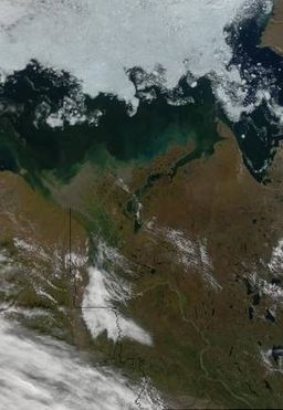 The lower Mackenzie River at the end of August. Source: NASA.
|
|
| Countries | Canada, Northwest Territories |
|---|---|
| Tributaries | |
| - left | Liard, Arctic Red |
| - right | Great Bear |
| Source | |
| - location | Great Slave Lake, Northwest Territories, Canada |
| - elevation | 156 m (512 ft) |
| - length | 2,503 m (8,212 ft) |
| Mouth | Mackenzie delta |
| - location | Arctic Ocean, Beaufort Sea, Canada |
| Length | 1,738 km (1,080 mi) |
| Basin | 1,805,200 km² (696,992 sq mi) |
| Discharge | for Arctic Ocean |
| - average | 10,700 m3/s (377,867 cu ft/s) |
| - max | 31,700 m3/s (1,119,475 cu ft/s) |
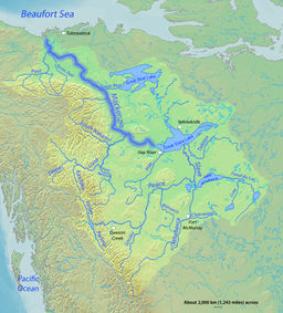 Map of the Mackenzie River watershed
|
|
The Mackenzie River (French: Fleuve Mackenzie) originates in Great Slave Lake, in the Northwest Territories, and flows north into the Arctic Ocean. It is the longest river in Canada at 1,738 kilometres (1,080 mi) and, together with its headstreams the Peace and the Finlay, the second longest river in North America at 4,241 kilometres (2,635 mi) in length.[1] The Mackenzie and its tributaries drain 1,805,200 square kilometres (697,000 sq mi).[2] Its mean discharge is 10,700 cubic metres per second (380,000 cu ft/s)
Contents |
History
The Mackenzie (previously Disappointment) River was named after Alexander Mackenzie, who traveled the river while trying to reach the Pacific Ocean in 1789. In the Dene languages it is called Deh Cho.
The Royal Canadian Mint honored the 200th anniversary of the naming of the Mackenzie River with the issue of a silver commemorative dollar in 1989.
Mallik methane hydrate field
In 2008, Canadian and Japanese researchers extracted a constant stream of natural gas from a test project at the Mallik methane hydrate field in the Mackenzie Delta. This was the second such drilling at Mallik: the first took place in 2002 and used heat to release methane. In the 2008 experiment, researchers were able to extract gas by lowering the pressure, without heating, requiring significantly less energy.[3] The Mallik gas hydrate field was first discovered by Imperial Oil in 1971-1972.[4]
Geography
The Mackenzie begins at the outlet of Great Slave Lake, as two separate waterways, North Channel and South Channel, which diverge around Big Island and flow into Beaver Lake. The river reforms at the outlet of Beaver Lake, receives the Kakisa River from the left, and immediately enters marshy Mills Lake. From there, the river courses west, then turns northwest at the Redknife River confluence, and again west where the Rabbitskin River enters. At Fort Simpson, it receives one of its principal tributaries, the Liard River, which at the confluence is nearly as large as the Mackenzie. About 110 kilometres (68 mi) later the Mackenzie turns northwards where the North Nahanni River enters from the left. The confluence with the Root and Willowlake Rivers occur soon after.
Surging northwards, the river soon passes the settlement of Wrigley, passing into a valley between the Mackenzie Mountains on the west and the Franklin Mountains on the east. The Wrigley and Dahadinni Rivers enter from the left and the Ochre and Blackwater Rivers from the right. As the Mackenzie draws close to the west flank of the McConnell Range, it receives from the left the great tributaries of the Redstone River and Keele River. As it leaves the valley and turns west, the Great Bear River enters from the right. The river passes along the north side of the Mackenzie Plain and the south side of the Norman Range, flowing past the community of Norman Wells, then receives the Carcajou River from the left.
Shortly before the Mackenzie drops over the Sans Sault Rapids the Mountain River enters from the left, and the Hanna and Donnelly Rivers confluence from the right shortly after. The Ramparts River comes in on the left before the Mackenzie receives the Hare Indian River at Fort Good Hope. The Ontaratue River flows in from the left near Andersons Landing, and the Gossage River from the same bank about 20 kilometres (12 mi) later. South of the Ramparts Plateau the Mackenzie bends southwest and receives the Arctic Red River at Tsiigehtchic, whereupon it turns northwest. The Mackenzie then spreads into a vast delta, in which the Peel River joins, splitting into thousands of channels before finally flowing to the Beaufort Sea.
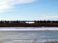
The river is navigable for approximately five months of the year. It freezes over in October and the ice on the river breaks up in May. During the winter months, sections of the river are used as an ice road.
During the ice-free period the river is navigable over its entire length. Barge traffic from an intermodal hub at the railhead at Hay River serves much of the Western Arctic.
The divide between the Mackenzie basin and the basin of the Yukon River to the west forms the central portion of the boundary between the Northwest Territories and Yukon. One of the river's major tributaries, the Great Bear River drains Great Bear Lake and inflow into the Mackenzie's lower course.
Communities on the Mackenzie
From south to north the communities along the river are:
- Fort Providence
- Jean Marie River
- Fort Simpson
- Wrigley
- Tulita
- Norman Wells
- Fort Good Hope
- Tsiigehtchic
Also in the Mackenzie delta are:
- Aklavik
- Inuvik
Crossings
NWT Highway 3 crosses the Mackenzie near Fort Providence. The current ferry and ice road will be replaced in 2011 by the Deh Cho Bridge, currently under construction.
NWT Highway 1 crosses the Mackenzie at Camsell Bend (N'Dulee Crossing) via ferry/ice road on the way to Wrigley.
NWT Highway 8 (the Dempster Highway) crosses the Mackenzie at Tsiigehtchic at the confluence with the Arctic Red River, on the way to Inuvik, also via ferry/ice road.
Wildlife and vegetation
There are a variety of flora and fauna species within the Mackenzie River Basin. Some of the dominant trees are White Spruce,[5] Engelmann Spruce and Black Spruce; for Black Spruce, this watershed is at the approximate northwest tip of that tree's distribution.[6]
The large marshy delta of the Mackenzie River provides habitat for migrating Snow Geese, Tundra Swans, and Brant as well as breeding habitat for other waterfowl. The estuary is a popular birthing area for Beluga whales.
Tributaries
From origin to mouth, the Mackenzie River receives the waters of the following rivers:
| Tributary | Coordinates |
|---|---|
| Great Slave Lake | |
| Kakisa River | |
| Horn River | |
| Bouvier River | |
| Redknife River | |
| Trout River | |
| Jean Marie River | |
| Spence River | |
| Rabbitskin River | |
| Liard River | |
| Harris River | |
| Martin River | |
| Trail River | |
| North Nahanni River | |
| Root River | |
| Willowlake River | |
| River Between Two Mountains | |
| Wrigley River | |
| Ochre River | |
| Johnson River | |
| Blackwater River | |
| Dahadinni River | |
| Saline River | |
| Redstone River | |
| Keele River | |
| Great Bear River | |
| Little Bear River | |
| Carcajou River | |
| Mountain River | |
| Donnelly River | |
| Tsintu River | |
| Hare Indian River | |
| Loon River | |
| Tieda River | |
| Gillis River | |
| Gossage River | |
| Thunder River | |
| Tree River | |
| Rabbit Hay River | |
| Arctic Red River | |
| Peel River | |
| Rengleng River |
See also
- List of rivers of the Northwest Territories
- List of rivers of Yukon
- Steamboats of the Mackenzie River
References
- Arthur C. Benke and Colbert E. Cushing. 2005. Rivers of North America, Academic Press, 1144 pp ISBN 0120882531, 9780120882533
- C. Michael Hogan. 2008. Black Spruce: Picea mariana, GlobalTwitcher.com, ed. Nicklas Stromberg, November, 2008
- Thomas Brodie. 2008. Researchers extract methane gas from under permafrost, Northern News Services accessdate=2008-06-16
Line notes
- ↑ Atlas of Canada. "Rivers in Canada". http://atlas.nrcan.gc.ca/site/english/learningresources/facts/rivers.html. Retrieved 2008-03-16.
- ↑ Mackenzie River. (2006). In Encyclopædia Britannica. Retrieved September 12, 2006, from Encyclopædia Britannica Premium Service
- ↑ Thomas Brodie. 2008
- ↑ "Geological Survey of Canada, Mallik 2002". Natural Resources Canada. 2007-12-20. http://gsc.nrcan.gc.ca/gashydrates/mallik2002/index_e.php. Retrieved 2008-06-16.
- ↑ Arthur C. Benke and Colbert E. Cushing. 2005
- ↑ C. Michael Hogan. 2008
External links
- Information and a map of the Mackenzie's watershed
- Canadian Council for Geographic Education page with a series of articles on the history of the Mackenzie River.
- Atlas of Canada's page devoted to Arctic rivers of Canada.
- MAGS: Daily Discharge Measurements.
|
|||||||||||