Malvern, Worcestershire
| Malvern | |
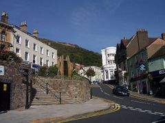 View of the junction of Church Street and Bellevue Terrace in Great Malvern, the town centre of Malvern, with North Hill in background, and the Elgar Enigma statue to the left. |
|
 Malvern
|
|
| Population | 28,749 (2001 Census) |
|---|---|
| OS grid reference | |
| - London | 121.3 miles (195.2 km) |
| Parish | Malvern |
| District | Malvern Hills |
| Shire county | Worcestershire |
| Region | West Midlands |
| Country | England |
| Sovereign state | United Kingdom |
| Post town | MALVERN |
| Postcode district | WR14 |
| Dialling code | 01684 |
| Police | West Mercia |
| Fire | Hereford and Worcester |
| Ambulance | West Midlands |
| EU Parliament | West Midlands |
| UK Parliament | West Worcestershire |
| List of places: UK • England • Worcestershire | |
Malvern is a town and civil parish in Worcestershire, England,[1] governed by the Malvern Town Council.[2] It has a population of 28,749 (2001 census), and includes the historical settlement and commercial centre of Great Malvern on the steep eastern flank of the Malvern Hills, and the former independent urban district of Malvern Link. Many of the major suburbs and settlements that comprise the town are separated by large tracts of open common land and fields and, together with smaller civil parishes[3] adjoining the town council boundaries and the hills, the built up area is often referred to collectively as The Malverns.[4]
Archaeological evidence suggests that Bronze Age people had settled in the area around 1000 BC, although it is not known whether these settlements were permanent or temporary.[5] The town itself was founded in the 11th century when Benedictine monks established a priory at the foot of the highest peak of Malvern Hills.[6][7] During the 19th century Malvern developed rapidly from a village to a sprawling conurbation due its popularity as a hydrotherapy spa based on its spring waters.[8] Immediately following the decline of spa tourism towards the end of the 19th century, the town's focus shifted to education with the establishment of several private boarding schools in former hotels and large villas. A further major expansion started when the Telecommunications Research Establishment (TRE) relocated to Malvern in 1942. QinetiQ, TRE's successor company, remains the largest local employer to the present day.[9]
Malvern is the largest urban development in the parliamentary constituency of West Worcestershire and according to the 2001 United Kingdom Census the civil parish had a population of 28,749.[10] Malvern is also the administrative seat of the area governed by Malvern Hills District Council (MHDC) and lies adjacent to the Malvern Hills Area of Outstanding Natural Beauty.
Contents |
History
Prehistory
The name Malvern probably comes from the ancient British language meaning 'Bare-Hill', the nearest modern equivalent being the Welsh moelfryn (bald hill). It has been known as Malferna (11th century), Malverne (12th century), and Much Malvern (16–17th century).[11]
Flint axes, arrowheads, and flakes found in the area are attributed to early Bronze Age settlers,[12]:2 and the 'Shire Ditch', a late Bronze Age boundary earthwork possibly dating from around 1000 BC, was constructed along part of the crest of the hills near the site of later settlements.[5] The Wyche Cutting, a mountain pass through the hills was in use in prehistoric times as part of the salt route from Droitwich to South Wales.[12]:3 A 19th century discovery of over two hundred metal money bars suggests that the area had been inhabited by the La Tène people around 250 BC.[12]:5 Ancient folklore has it that the British chieftain Caractacus made his last stand against the Romans at the British Camp,[13] a site of extensive Iron Age earthworks on a summit of the Malvern Hills close to where Malvern was to be later established. The story remains disputed, however, as Roman historian Tacitus implies a site closer to the river Severn.[14] There is therefore no evidence that Roman presence ended the prehistoric settlement at British Camp. However, excavations at nearby Midsummer Hillfort, Bredon Hill and Croft Ambrey all show evidence of violent destruction around the year 48 AD. This may suggest that the British Camp was abandoned or destroyed around the same time.[15]
Monastic Malvern

History waits another thousand years before describing "... an hermitage, or some kind of religious house, for seculars, before the conquest, endowed by the gift of Edward the Confessor...".[6] The additions to the antiquary William Dugdale's Monasticon gives an extract from the Pleas taken before the King at York in 1387, stating that there was a congregation of hermits at Malvern "some time before the conquest".[7] Although a Malvern priory existed before the Norman Conquest, it is the settlement of nearby Little Malvern, the site of another, smaller priory, that is mentioned in the Domesday Book.[16] A motte-and-bailey castle that was built on the top tier of the earthworks of the British Camp just before the Norman Conquest was probably founded by the Saxon Earl Harold Godwinson of Hereford.[17] It was destroyed by King Henry II in 1155.[18]
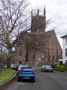
The town developed around its 11th-century priory, a Benedictine monastery, the remains of which make up some of the early parts of Great Malvern Priory, now a large parish church.[11] Several slightly different histories explain the actual founding of the religious community. Legend tells that the settlement began following the murder of St. Werstan, a monk of Deerhurst, who fled from the Danes and took refuge in the woods of Malvern, where the above-mentioned hermitage had been established.[6][19] Although the legend has been dismissed by some historians as monastic mythology, historians Cora Weaver and Bruce Osborne re-examined the legend of St Werstan and concluded that he was the original martyr.[20]
The first prior was Aldwyn,[19] who founded the monastery on his bishop's advice, and by 1135 the monastery included thirty monks. Aldwyn was succeeded by Walcher, an astronomer and philosopher from Lorraine,[19] whose gravestone inside the priory church records details that the priory arose in 1085 from a hermitage endowed by Edward the Confessor. An ancient stained glass window[21] in the Priory church depicts the legend of St. Werstan, with details of his vision, the consecration of his chapel, Edward the Confessor granting the charter for the site, and Werstan's martyrdom.[22]
An 18th century document states that in the 18th year of William's kingship (probably 1083), a priory was dedicated to St Mary the Virgin.[23] Victoria County History describes how a hermit Aldwyn, who lived in the reign of Edward the Confessor, had petitioned the Earl of Gloucester for the original site (of the Priory) in the wood, and cites his source as 'Gervase of Canterbury, Mappa Mundi (Rolls ser.)'.[24]
Post-Dissolution
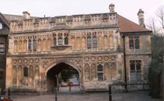
During the Dissolution of the Monasteries the local commissioners were instructed to ensure that, where abbey churches were also used for parish worship, they should continue or could be purchased by parishioners. Accordingly, Malvern Priory survived by being acquired by a William Pinnocke and with it, much of the 15th century stained glass windows.[25] The monastic buildings were taken apart and anything usable was sold off. With the exception of the church building (of which the south transept adjoining the monastery's cloisters was destroyed), all that remains of Malvern's monastery is the Abbey Gateway (also known as the Priory Gatehouse) that houses today's Malvern Museum. Already an established community and the major settlement in the Malvern Chase, during the century that followed the town began to acquire its fame for its spring water.[25]
Victorian Spa
Malvern is a famous spa, known for its bottled water since 1622 at the Holy Well and later from other spouts and sources. In the early 19th century hydrotherapy based on the curative properties of the water became popular, and the town underwent a rapid expansion. Several large hotels and many of the large villas in Malvern date from its heyday as a residential spa. Many smaller hotels and guest houses were built between about 1842 and 1875. By 1855 there were already 95 hotels and boarding houses and by 1865 over a quarter of the town's 800 houses were boarding and lodging houses.[8][26] Most were in Great Malvern, the town centre, while others were in the surrounding settlements of Malvern Wells, Malvern Link, North Malvern and West Malvern.
Following the completion of the Worcester & Hereford Railway, Great Malvern railway station opened on 25 May 1860, a Friday start to a weekend public holiday. It received a massive 10,000 passengers from all the newly opened stations on the line, and throughout June to September of that year day trips were frequent, filling the area with "the most curious specimens of the British shopkeeper and artisan on an outing".[8] Following Malvern's new-found fame as a spa and area of natural beauty, and fully exploiting its new rail connections, factories from as far Manchester were organising day trips for their employees, often attracting as many as 5,000 visitors a day. In 1865, a public meeting of residents denounced the rising rail fares – by then twice that of other lines – that were exploiting the tourism industry, and demanded a limitation to the number of excursion trains. The arrival of the railway also enabled the delivery of coal in large quantities, which accelerated the area's popularity as a winter resort.[8] Fearing that Malvern would become the "Metropolis of Hydrotherapy", a Malvern Hills Act was secured in 1884 and later Acts empowered the Conservators to acquire land to prevent further encroachment on common land and by 1925 they had bought much of the manorial wastelands.[8]
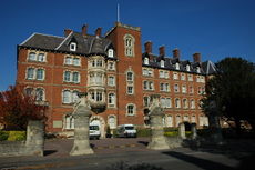
Towards the end of the 19th century, the popularity of the hydrotherapy had declined to the extent that many hotels were already being converted into private boarding schools and rest homes, and education became the basis of Malvern's economy.[8] By 1865, the town already had 17 single-gender private schools, increasing to 25 by 1885. The area was well suited for schools due to its established attractive environment and the possibility of children being able to travel unaccompanied with their trunks by rail to their boarding schools near the stations in Great Malvern, Malvern Wells, and Malvern Link, such as in the case of the Girls College in a former hotel directly opposite Great Malvern railway station, with its dedicated (now derelict) tunnel to the basement of the building, which is clearly visible from both platforms of the station.[27]
Governance
Malvern is the town and civil parish governed at the lowest tier of local government by Malvern Town Council, part of the Malvern Hills District of the County of Worcestershire, comprising of 54 civil parishes and 21 electoral council wards.[29] The present Malvern Town Council was created in 1996 as an autonomous local authority under the Local Government Act of 1972 and other Acts of Parliament. The ward boundaries were redefined from the wards of the former Malvern Urban District Council (1900–1974). Through the many changes in local government infrastructure since the beginning of the 20th century, the importance and distinction by local boundaries of the historical areas of Great Malvern, Malvern Link, North Malvern, Cowleigh, and other neighbourhoods, have been lost.
The original parish of Great Malvern included the hamlet of Guarlford and the chapelry of Newland, and stretched from the River Severn on the east to the Malvern Hills on the west. Guarlford became a separate civil parish in 1894 when, under the Local Government Act of 1894, urban district councils were created for Malvern and Malvern Link. The Guarlford parish covered much of eastern Malvern, including parts of Great Malvern, Pickersleigh, Poolbrook, Barnards Green, Hall Green and Sherrards Green. By 1900 however, the urban districts of Malvern and Malvern Link amalgamated, absorbing parts of neighbouring parishes to create a town of six wards under the Malvern Urban District Council.[8]:197 In 1934 the boundaries changed again, and those areas came under the control of the Malvern council.[30]
Residents of Malvern Town in the six Malvern Town Council electoral wards are represented by 20 elected members. The council is supported by a team of senior executives that includes a Town Clerk, a Deputy Town Clerk, a PA to the Town Clerk and Chairman, an Operations and Events Officer, a Finance Officer, two Operations Managers, an Operations Supervisor, and eight Grounds Maintenance Operatives.[2] The wards are based on the distribution of the population and generally ignore the names of the neighbourhoods and suburbs they contain, and use loaned names:
- Chase, covering Barnards Green, the extensive Ministry of Defence property occupied by QinetiQ, the campus of The Chase School, the village of Poolbrook, and the largely rural south-eastern area of the adjoining Poolbrook and Malvern commons.
- Dyson Perrins, the northern part of Malvern adjacent to Link with the campus of Dyson Perrins School and the former MoD DERA North Site, and the former hamlets of Interfield, Halfkey, and Upper Howsel.
- Link, that covers most of the area north of the Link Common between Link Top and Newland, and Upper and Lower Howsel.
- North Malvern, (referred to as 'West' on ONC maps), an area between Link Top (Link) and West Malvern civil parish, that includes the former village of Cowleigh.
- Pickersleigh, that includes the part of the former Great Malvern boundaries east of the railway between Barnards Green and Malvern Link to Madresfield, the former hamlets of Hall Green and Sherrards Green, and part of Barnards Green.
- Priory, that includes the town centre and areas west of the railway between North Malvern, and Malvern Wells civil parish.[31]
Geography
Town centre
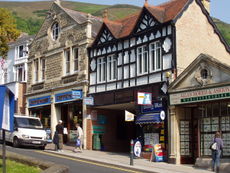
The town centre comprises two main streets at right angles to each other: the steep Church Street and Bellevue Terrace, a relatively flat north-south extension of the A449 which forms Malvern's western extremity along the flank of the hills. In the heart of the town is a statue of the composer Edward Elgar, who lived in the town, while other statuary is dedicated to Malvern water. Among the many shops are two large modern supermarkets, both in Edith Walk, a former steep and narrow back lane that runs parallel to Church Street. Most of the traditional high street shops such as clothing, butchers, bakeries, groceries, etc., in the town are now tea-rooms, health food shops, specialist cafés, building societies, second-hand books shops, art and craft shops, charity shops, law firms, and estate agents. On the Worcester to Hereford railway line is the Victorian Great Malvern station, a listed example of classical Victorian railway architecture close to the nearby former Imperial Hotel by the same architect.[27]
Suburbs and neighbourhoods
Malvern's rapid urbanisation during the latter half of the 19th century spread eastwards and northwards from Great Malvern, the traditional town centre on the steep flank of the Worcestershire Beacon, and engulfed the manors and farms in the immediate area. It was often the farms, such as Pickersleigh, near Great Malvern, and the Howsels in Malvern Link which merged with Great Malvern in 1900, that gave their names to many of the new neighbourhoods. The urban agglomeration continued to spread, and by the middle of the 20th century had reached the suburban parishes of West Malvern, Malvern Wells, Newland, Madresfield, and Guarlford.
Demography
As of the 2001 UK census, Malvern had a total population of 28,749. For the purposes of statistical reporting the Office of National Statistics groups the population of the North Malvern ward of the Malvern civil parish with that of the West Malvern civil parish.[32][33] For every 100 females, there were 91.7 males. The average household size was 2.4.[34] Of those aged 16–74 in Malvern, 48.1% had no academic qualifications or one General Certificate of Secondary Education (GCSE),[35] above the figures for all of the Malvern Hills local government district (39.7%) and England (45.5%).[36] According to the census, 2.3% were unemployed and 35.0% were economically inactive.[35] 19.7% of the population were under the age of 16 and 11.5% were aged 75 and over; the mean age of the people of the civil parish was 41.5. 66.8% of residents described their health as "good", similar to the average of 69.1% for the wider district.[36][37]
Population development
The area remained a village and cluster of manors and farms until 'taking of the water' in Malvern became popularised by Dr. Wall in 1756. By the 1820s the Baths and the Pump Room were opened; in 1842 Drs. James Wilson and James Manby Gully opened up water cure establishments in the town centre.[38] By the middle of the 19th century, with the arrival of the railway, bath houses and other establishments catering for the health tourists flourished. By the early 20th century Malvern had developed from a small village centred around its priory to a town with many large hotels and Victorian and Edwardian country villas.
Malvern experienced a further population boost in 1942 when the Telecommunications Research Establishment (TRE) relocated to Malvern bringing about 2,000 employees to Malvern, increasing to around 3,500 by 1945.[39] In the early 1950s, several large housing estates were built in Malvern to provide accommodation for the staff and their families. A significant proportion of the current population of Malvern are present and former employees of the facility (now called QinetiQ), and its previously attached military contingent.[40]
Malvern had already become an overspill for the nearby city of Worcester, and the new motorways constructed in the early 1960s brought the industrial Midlands within commuting distance by car. With this development came the construction of large private housing developments. The town continues to swell as increasingly more farmland, especially in the Malvern Link area between the villages of Guarlford and Newland, is turned over to housing projects creating new communities and suburbs.
| Year | Population | Notes |
|---|---|---|
| Due to frequent merging of parishes and changes in boundaries, accurate figures based on specific areas are not available. | ||
| 1563 | 105 families | Probably what is now the town centre area with nearby farms and manors.[11] |
| 1741 | had sixty houses | Probably what is now the town centre area.[11] |
| 1801 | 819 | [8] |
| 1819 | 2,768 | 1819 census - probably what is now the town centre area.[11] |
| 1851 | 3,771 | Probably including the former ecclesiastical parishes of Guarlford and Newland, and the settlement of Poolbrook.[11] |
| 1871 | 7,605 | |
| 1911 | 16,514 | Reflects the 1900 merging of the Malvern and Malvern Link urban district councils.[8] |
| 2001 | 28,749 | Includes the six wards covered by the current Town Council civil parish.[41] |
Economy
Research
Scientific research has been the major source of local employment since the Telecommunications Research Establishment (TRE), a government group developing RADAR for the RAF, relocated to Malvern in 1942. TRE moved from near Swanage on the south coast for safety from air raids and espionage during World War II, initially using the premises of Malvern College.[39] The establishment has been through a series of name changes, but has remained the largest single employer in the Malvern area.[9] It has made many major contributions to global science and technology include the cavity magnetron, liquid crystal displays (LCD) and thermal imaging.[42] In 2001 the facility was partly privatised to become QinetiQ, while a small part was retained by the Ministry of Defence to become Dstl, the Defence Science and Technology Laboratory. Malvern's Dstl contingent has since closed down with the remaining staff moving to other Dstl sites.
Manufacturing
Cars have been constructed in Malvern since 1910 by the Morgan Motor Company, one of the world's longest existing private constructors of series-built automobiles. The Morgan Motor Car is a traditional sports roadster and over the years has become a 'cult' vehicle, exported all over the world.[43]
Pipe organs have been built in Malvern since Nicholson Organs was founded by John Nicholson in 1841. Nicholson organs can be found in Gloucester and Portsmouth Cathedrals, and Great Malvern Priory.[44]
Specialist glass tubing and microscope slides are produced by Chance Brothers in their factory in Malvern next door to the Morgan Motor works.[45]
Agriculture
Malvern is a centre for agricultural industry. The 70 acre Three Counties Showground, operated by the Three Counties Agricultural Society,[46] is a few miles to the south of Malvern on the road to Upton upon Severn. It has been the venue for the Three Counties Show, held each year in June, for over fifty years. Representing the counties of Worcestershire, Herefordshire and Gloucestershire, it is among the country's most important agricultural shows,[47], and can be traced back to 1797.[47] It attracts an average of 93,000 visitors from all parts of the country over its three-day event, and with around 600 trade stands and exhibitions it almost doubles the town's local population.[47] The showground also opens the horticultural season each year by hosting the Royal Horticultural Society's Spring Gardening Show,[48] followed by many other events throughout the year including other regular gardening shows.
Culture
Architecture
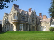
The town centre and its environs are graced by many examples of Regency, Victorian and Edwardian villas and hotels. Many of the houses were built during the Industrial Revolution, and Malvern's boom years as a spa town, by wealthy families from the nearby Birmingham area. Following the collapse of the spa industry, many of the hotels and villas became schools, and have since been further converted to apartments, while some of the smaller hotels are now retirement homes. The Imperial Hotel in red brick with stone dressings, which later became a school, is one of the largest buildings in Malvern and was built in 1860 by the architect E. W. Elmslie who also designed the Great Malvern railway station, the Council House on the plot where Dr. Gully's original house stood, The Grove in Avenue Road in 1867, originally to be his private residence which in 1927 it became part of the Lawnside School for girls,[49] and Whitbourne Hall, a Grade II* listed building, in 1860 in Herefordshire.[50] The Imperial was the first hotel to be lit by incandescent gas. It was equipped with all types of baths and brine was brought specially by rail from Droitwich.[51] Much architecture and statuary in the town centre is dedicated to Malvern Water, including the St Ann's Well, which is housed in a building dating from 1815.[52] The drinking spout, Malvhina, by the sculptor Rose Garrard, was unveiled on 4 September 1998. The Enigma Fountain, also by Garrard, was unveiled by Prince Andrew in 2000.
Music
Sir Edward Elgar, British composer and Master of the King's Musick, lived much of his life around Malvern and is buried in Little Malvern cemetery. Land of Hope and Glory, set to Elgar's Pomp and Circumstance March No. 1, was first performed in the Wyche School next to the church in the presence of Elgar. A statue of Elgar stands gazing over Great Malvern from Belle Vue Terrace in the town centre. The Elgar Route, a 40-mile drive passing some key landmarks from Elgar's life, passes through Malvern.[53] The Chandos Symphony Orchestra is one of the leading amateur orchestras in the West Midlands.[54] Based in Malvern under the professional direction of Michael Lloyd with over 100 players, the orchestra specialises in performances of major works of the 19th and 20th Centuries.[54] The Autumn in Malvern Festival is an annual event featuring performances of renowned artists of music, poetry, writers and film makers held during October every year.[55]
Dramatic arts
Malvern theatre, housed in the Winter Gardens complex in the town centre, is a leading provincial centre for the arts.[56] The first Malvern Drama Festival, which took place in 1929, was dedicated to Bernard Shaw and planned by Sir Barry Jackson.[57] Many premiers of works by famous playwrights had their first performances at Malvern, including two by Bernard Shaw. In 1956, on the occasion of the dramatist's 100th birthday, Malvern held a Shaw centenary week. In February 1965 a Malvern Festival Theatre Trust was set up, and extensive refurbishment was undertaken. J B Priestley presided over the opening ceremony of the first summer season. In 1998 a further £7.2 million major redesign and refurbishment took place with the help of contributions from the The National Lottery Distribution Fund (NLDF), administered by the government Department for Culture, Media and Sport.[56]
The Theatre of Small Convenience entered the Guinness Book of World Records in 2002 as the smallest theatre in the world. Located in a former Victorian public convenience in the centre of the town, the theatre has a capacity of 12 people.[58] The theatre regularly hosts puppetry, professional and amateur actors, drama, poetry, storytelling and opera, and has become a regular venue of the Malvern Fringe Festival.
Malvern Fringe Festival, officially founded 1977, is one of the oldest Fringe festivals in the world. It takes place over three days in June as a fringe to the Elgar Festival. The Fringe also organise an annual May Day celebration, and various musical and other live events throughout the year.[59] The Fringe aims to be inclusive; bridging the generation gap by providing a varied programme of events for the local people of Malvern aimed at all ages.
Malvern in literature
C. S. Lewis and J. R. R. Tolkien are among the authors that have frequented Malvern. Legend states that, after drinking in a Malvern pub one winter evening, they were walking home when it started to snow. They saw a lamp post shining out through the snow and Lewis turned to his friends and said "that would make a very nice opening line to a book". Lewis' book The Lion, the Witch and the Wardrobe later used that image as the characters enter the realm of Narnia.[60]
J.R.R. Tolkien found inspiration in the Malvern landscape. He was introduced to the area by C. S. Lewis, who had brought him here to meet George Sayer, the Head of English at Malvern College. Sayer had been a student of Lewis, and became his biographer, and together with them Tolkien would walk the Malvern Hills. Excerpts from The Hobbit and The Lord of the Rings were recorded in Malvern in 1952, at the home of George Sayer. The recordings were later issued on long-playing gramophone records.[61] In the liner notes for J.R.R Tolkien Reads and Sings his The Hobbit & The Fellowship of the Rings, George Sayer wrote that Tolkien would relive the book as they walked and compared parts of the Malvern Hills to the White Mountains of Gondor.[62]
The poet W. H. Auden taught for three years in the 1930s at The Downs School, in the Malvern Hills. He wrote many poems there, including: This Lunar Beauty; Let Your Sleeping Head; My Love, Fish in the Unruffled Lakes; and Out on the Lawn I Lie in Bed. He also wrote the long poem about the hills and their views, called simply The Malverns.[63][64]
William Langland's famous 14th century poem The Visions of Piers Plowman (1362) was inspired by the Malvern Hills and the earliest poetical allusion to them occurs in the poem And on a Maye mornynge on Malverne hylles. Langland, the reputed writer, was possibly educated at the priory of Great Malvern.[65] Several roads and buildings in Malvern are named after Langland.
Malvern on screen
The Malvern landscape forms the backdrop for Penda's Fen, a 1974 British Television play written by David Rudkin and directed by Alan Clarke for the BBC's Play for Today series. It tells the story of Stephen, a pastor's son who has visions of angels, Edward Elgar, and King Penda, the last pagan ruler of England.[66][67] The final scene of the play, where the protagonist has an apparitional experience of the "mother and father of England" and King Penda, is set on the Malvern Hills.[68]
Malvern water
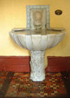
Malvern water flows freely from a number of fountains or spouts throughout the Malvern area. Upkeep of these historical springs is funded by several organisations, including the Town Council, the Heritage Lottery Fund, The Malvern Spa Association, and the Area of Outstanding Natural Beauty. The water became famous for containing "nothing at all".[69] It was the reason for Malvern becoming a spa town and has formed a part of both local and national culture since Queen Elizabeth I made a point of drinking it in public in the 16th century, and Queen Victoria refused to travel without it. It is the only bottled water used by Queen Elizabeth II, which she takes on her travels around the world. Millions of litres of Malvern water are bottled annually by Coca Cola Enterprises under the Schweppes brand in a factory near Malvern and distributed worldwide.[70]
Places of worship
In addition to the 12th century priory, during and shortly after Malvern's expansion throughout the second half of the 19th century over twenty Christian churches, and several other places of worship were built in Malvern, many of which are reproductions of 13th and 14th century architecture including St Mathias, Malvern Link (CofE) c1896, which has a full set of ten ringing bells on which the first full peal of Grandsire Triples was rung on 1 June 1901.[71] One of the most recent buildings is St Mary's Church (CofE), in Sherrards Green, a modern church built c1960.
Health facilities
Malvern has a community hospital in Lansdowne Crescent, near the town centre[72] used mainly by the elderly and for convalescence, although consultants from major Worcester NHS hospitals hold clinics there. Major health facilities are provided by hospitals in Worcester. Work on a new hospital for the Malvern area began in April 2009 in Malvern Link, due to open in Autumn 2010.[73] The town has seven health centres,[74] including a health complex in Malvern Link[75] and a group practice on Pickersleigh Road.[76] Malvern also has several nursing and retirement homes for the care of senior citizens. The Malvern area is covered by the Midlands Air Ambulance service, which has operated from the site of Strensham motorway services since 1991.[77]
Transport
Road and rail
The A449 road runs through the centre of Malvern, connecting it to Worcester and Ledbury. The M5 motorway to the east of Malvern is accessible at junctions 7 and 8. The M50 (also known as the Ross Spur) to the south can be accessed at junction 1 on the A38 road between Tewkesbury and Malvern. Malvern has two railway stations (Great Malvern and Malvern Link), providing direct services to Worcester, Hereford, Birmingham, Oxford and London.
Bus
Several local bus services connect Malvern with the surrounding area.[78] Long-distance direct bus services connect Malvern with other cities in the country, including the National Express route 321 through eleven counties from Aberdare in South Wales via Birmingham and other major cities, to Bradford in West Yorkshire,[79] and route 444 from Worcester to London (Victoria).[79]
| Route | From | To | Via | Operator | Notes |
|---|---|---|---|---|---|
| 42/42A | Malvern Link | Fruitlands | Great Malvern, Poolbrook | Astons Coaches | [80] |
| 44/44A/44B | Malvern Link | Worcestershire Royal Hospital | Great Malvern, Powick, Worcester, County Hall | Diamond Bus, First | [81] |
| 363 | Barnards Green | Worcester | Great Malvern, Malvern Wells, Welland, Upton-upon-Severn, Hanley Swan, Callow End, Powick | Diamond Bus | [82] |
| 377 | Malvern Link | Cheltenham | Great Malvern, Malvern Wells, Welland, Pendock, Eldersfield, Gloucester | Diamond Bus | [83] |
| 425 | Malvern Link | Knightwick | Great Malvern, Leigh Sinton, Bransford, Alfrick, Suckley | Diamond Bus | [84] |
| 476 | Great Malvern | Hereford | Colwall, Ledbury, Bartestree, Lugwardine | DRM Coaches | [85] |
| 675 | Great Malvern | Ledbury | West Malvern, Wyche Cutting, Colwall | DRM Coaches | [86] |
Air
Malvern's nearest major airport is Birmingham International approximately one hour by road via the M5 and M42 motorways. Gloucestershire Airport located at Staverton, in the Borough of Tewkesbury near Malvern is a busy General Aviation airport used mainly for private charter and scheduled flights to destinations such as the islands of Jersey, Guernsey, and the Isle of Mann, pilot training, and by the aircraft of emergency services.[87]
Education
Malvern is home to two large state comprehensive schools fed by twelve state or Church of England primary schools in the town. Two large public schools - Malvern College for boys and Malvern St James's for girls - now remain following mergers of Malvern's many private primary and secondary schools.[88][89]
High schools
The Chase Technology College in Barnards Green has over 1700 pupils. It is a specialist Technology, Language and Science college under the specialist schools programme, and has been awarded Beacon School status. At the last OFSTED inspection (February 2006), the school was described as "good with some outstanding features". Average GCSE results in 2008 were 382.7 with 54% of pupils achieving grade A*-C; average A level results in 2008 were 735.9.[90]
Dyson Perrins CE Sports College in Malvern Link, a Church of England school with almost 1000 pupils, is a specialist Sports College. Following a critical OFSTED inspection in January 2009 the school was placed in special measures.[91] Average GCSE results in 2008 were 344.8 with 40% of pupils achieving grade A*-C; average A level results in 2008 were 797.3.[90]
Independent schools
Malvern College is a coeducational public school, founded in 1865. Until 1992, it was a school for boys aged 13 to 18. Following a series of mergers from 1992 to 2008 with private primary schools in the area it has become coeducational with pupils from 3 to 18 years old. Among its alumni are two Nobel Laureates (James Meade[92] and Francis William Aston[93]), an Olympic Gold medalist (Arnold Jackson),[94] and leading politicians.
Malvern St James was formed in 2006 by the merger of Malvern Girls' College and St. James's School, West Malvern (formerly St James's and The Abbey) and other mergers with local private schools over the last thirty years. It is now the last of the independent girls school in the Malvern area. The main building of Malvern St James on the campus of the former Malvern Girls' College is the former Imperial Hotel, built in the second half of the 19th century.[88]
The Abbey College is an international boarding school providing education mainly for students from countries outside the United Kingdom. Founded in 1974, it provides pre university preparation for mixed gender students aged 14 to 20, mainly from countries outside the United Kingdom.
Further education
The Malvern campus of South Worcestershire College is a centre for further education providing government certificate vocational courses for adults and post 14 year old students.[95] Malvern also has an active University of the Third Age that was founded at Malvern Hills College in 1995. Its inaugural meeting was attended by around 150 members of the public, and by 2009 it had over 70 interest groups and 1000 members.[96]
Leisure
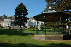
The Priory Park with its adjoining Malvern Splash pool and Winter Gardens complex occupies a large area in the centre of the town. The Winter Gardens complex is home to the Malvern Theatre, a cinema, a concert venue/banqueting room, bars and cafeterias.[57] For almost half a century, the Malvern Winter Gardens has also been a leisure centre and a major regional venue for classical music, and concerts by legendary rock bands of the 60s, 70s and 80s.[97] The Splash Leisure Complex flanks the eastern boundary of Priory Park and has an indoor swimming pool and gymnasium. In the town centre is also an extensive Public Library that includes access to the Internet and many community services.
Sport
The Manor Park Club multi-sports complex, close to the town centre, provides the area with indoor and outdoor sports facilities including tennis, squash, indoor bowls, racketball, archery and table tennis. It is assisted by grants from various bodies, including the Malvern Hills District Council, the Sport England Lottery, and the Lawn Tennis Association.[98] Traditional outdoor bowls are played on a green in Priory Park. Other public areas such as Victoria Park in Malvern Link provide space for field sports and tennis. Malvern Town FC has a football first team that plays in the Southern League Division One Midlands and which has twice reached the third qualifying round of the FA Cup. The Malvern Hills are a popular launching site for hang gliding and paragliding and Malvern has a local hang gliding club.[99] Snooker is played at the Willy Thorne Snooker Centre in Malvern which is a regular venue for world-class matches played by past and present world champions. Cricket is provided for at Barnards Green Cricket Club, a professional class ground.[100]
Notable people
Many of Malvern's notable people came to the town to be educated, or teach, at one of the public schools. Composers were drawn to Malvern for the quality of its church organs and the acoustics of the church buildings. The Hills inspired many poets and novelists,[60][63] while scientists carried out world leading research at what is now QinetiQ.[42]
- James Jesus Angleton (1917–1987), chief of the CIA counter-intelligence (CI) staff (Associate Deputy Director of Operations for Counter-Intelligence/ADDOCI), was educated at Malvern College.
- James Atkinson (physicist), Worked at the Telecommunications Research Establishment (TRE - now QinetiQ) where he researched radar and guided missile weapons technology.
- Thomas Attwood, British economist and campaigner for electoral reform, died in Malvern, on 9 March 1859.
- W. H. Auden, poet and playwright, taught 1930-1933 at the Downs School, Colwall.
- David Bilsborough, author of The Wanderer's Tale and A Fire in the North novels that form part of the Annals of Lindormyn series, was born and raised in Malvern.[101]
- Benedict Carpenter, sculptor and artist, was born in Malvern and educated at Malvern College.
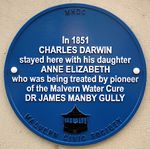
- Anne, Charles Darwin's daughter, is buried in the graveyard of Malvern Priory.
- Anne Diamond, television journalist and presenter, grew up in Malvern.
- Edward Elgar, composer, taught in Great Malvern and much of his work was influenced by the Malvern Hills. Elgar is buried at St. Wulstan's, Little Malvern.
- Charles Thomas Elliott, FRS, CBE, was a scientist at the RRE and its successor QinetiQ from the late 1960s to 1999.
- Basil Foster (1882-1959), English cricketer who played 34 first-class matches in the early 20th century, was born in Malvern.
- Julius Harrison (1885-1963), was a contemporary of Elgar, and Professor of Composition at the Royal Academy of Music. He was music director at Malvern College and director of the early Elgar Festivals in Malvern. He lived in Pickersleigh Road from most of the 1940s.[102]
- Charles Hastings, founder of the British Medical Association, spent his final years at Hastings House, Barnards Green.
- Graeme Hick, cricketer, currently resides in the Malvern area, and coaches at Malvern College.
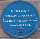 Roosevelt plaque, Aldwyn Tower, Malvern
 - Prince Joachim of Belgium, Archduke of Austria-Este is currently (2009) a pupil at Malvern College.
- Nigel Kennedy, British violinist, lived in West Malvern for a while.
- William Langland's allegorical narrative poem Piers Plowman (written c. 1360–1387) begins on the Malvern Hills.
- C. S. Lewis, novelist, was a pupil at the preparatory school Cherbourg House and Malvern College.
- Jenny Lind, opera singer, lived and died in Malvern, and is buried in Great Malvern cemetery.
- Ellen Marriage, pioneer Balzac translator, died in Malvern in 1946.
- Peter Mark Roget, lexicographer, is buried in the graveyard of St James, West Malvern.
- Franklin D. Roosevelt, president of the USA, stayed at the Aldwyn Tower Hotel while convalescing from an illness at the age of 7.
- George Sayer, biographer of C. S. Lewis.
- Haile Selassie, emperor of Ethiopia, spent part of his exile in Malvern, at the Abbey Hotel.[103]
- Jacqui Smith, former British Home Secretary, was born and raised in Malvern.
- Philip Woodward, British mathematician and horologist, one of the chief developers of radar, worked at TRE (where a building was later named for him) and still lives in Great Malvern as of July 2009.
- Cher Lloyd, singer currently performing in the X-Factor contest.
Compass
 |
Bromyard, Tenbury Wells, Leominster, North Wales | Leigh Sinton, Kidderminster, Birmingham | Powick, Callow End, Worcester, Coventry | |
| Cradley, Mathon, Hereford | Pershore, Evesham, Banbury | |||
| Colwall, Eastnor, Ledbury | Welland, Gloucester | Hanley Swan, Hanley Castle, Upton-upon-Severn, Tewkesbury, Oxford, London |
References
- ↑ "About Malvern". Malvern Town Council. http://www.malverntowncouncil.org/about_malvern.php. Retrieved 5 January 2010.
- ↑ 2.0 2.1 "About Malvern Town Council". Malvern Town Council. http://www.malverntowncouncil.org/about_mtc.php. Retrieved 5 August 2009.
- ↑ "What is a town, parish or community council?". National Association of Local Councils. http://www.nalc.gov.uk/About_NALC/What_is_a_parish_or_town_council/What_is_a_council.aspx. Retrieved 26 December 2009.
- ↑ "District Centres". Malvern Hills District Council. http://www.malvernhills.gov.uk/cms/business/district-centres.aspx. Retrieved 5 January 2010.
- ↑ 5.0 5.1 English Heritage. "Malvern Hills". English Heritage. http://www.english-heritage.org.uk/server/show/nav.1206. Retrieved 18 December 2009.
- ↑ 6.0 6.1 6.2 Nott, James (1885). Some of the Antiquities of Moche Malvern (Great Malvern). Malvern: John Thompson. p. 14. http://www.archive.org/stream/someofantiquitie00anotuoft#page/n5/mode/2up. Retrieved 6 January 2010.
- ↑ 7.0 7.1 Dugdale, Sir William (1693). Monasticon Anglicanum or The History Of the Ancient Abbies, and other Monasteries, Hospitals, Cathedral and Collegiate Churches, in England and Wales. With Divers French, Irish, and Scotch Monasteries Formerly relating to England (Translated from the Latin). London: Sam Keble and Hen Rhodes. p. 234. http://www.archive.org/stream/monasticonanglic00dugd#page/234/mode/2up/search/malvern. Retrieved 3 January 2010.
- ↑ 8.0 8.1 8.2 8.3 8.4 8.5 8.6 8.7 8.8 Hembry, Phylis May (Deceased); Cowie, Leonard W; Cowie, Evelyn E (Completing editors) (1997). British spas from 1815 to the present. Madison, N.J: Fairleigh Dickinson University Press. ISBN 0838637485. http://books.google.com/?id=QvDWk4YMAR8C&lpg=PA197&dq=Malvern%20Link%20%20urban%20district&pg=PA197#v=onepage&q=Malvern%20Link%20%20urban%20district.
- ↑ 9.0 9.1 "Key Statistics". Malvern hills District Council. 24 September 2009. http://www.malvernhills.gov.uk/cms/business/key-statistics.aspx. Retrieved 10 January 2010.
- ↑ "Neighbourhood Statistics, Malvern CP (Parish)". Office of National Statistics. 28 April 2004. http://neighbourhood.statistics.gov.uk/dissemination/LeadTableView.do?a=3&b=800846&c=Malvern&d=16&e=15&g=499174&i=1001x1003x1004&o=1&m=0&enc=1&dsFamilyId=779. Retrieved 4 August 2009.
- ↑ 11.0 11.1 11.2 11.3 11.4 11.5 Page, William; Willis-Bund, J. W., eds (1924). Victoria County History, Worcestershire. 4. London, UK. pp. 123–134. http://www.british-history.ac.uk/report.aspx?compid=42867.
- ↑ 12.0 12.1 12.2 Smith, Brian S. (1978) [1964]. A History of Malvern. Leicester, UK: Leicester University Press. pp. 2,3,5. ISBN 0904387313.
- ↑ BBC (June 2003). "Malvern Hills - British Camp". BBC Hereford & Worcester. http://www.bbc.co.uk/herefordandworcester/features/malverns/new_malverns_history.shtml. Retrieved 4 August 2009.
- ↑ Tacitus; Woodman, Anthony John (translator) (2004). "The Annals". Hackett Publishing Company. ISBN 0872205584. See also Church & Brodribb's translation or searchable text at Internet Archive
- ↑ Hencken, T. (1938). The Excavation of the Iron Age Camp on Bredon Hill, Gloucestershire 1935-1937. 95. Heritage Marketing and Publications.
- ↑ Great Domesday Book. William the Conqueror. 1086. pp. folio 173r.
- ↑ Remfry, Paul (1998). The Herefordshire Beacon of King Harold II and the Earls of Hereford and Worcester. ukprint.com. ISBN 1-899376-32-1.
- ↑ Remfry, Paul (20 February 2008). "The history of British Camp". BBC Hereford & Worcester. http://www.bbc.co.uk/herefordandworcester/content/articles/2008/02/19/british_camp_book_feature.shtml. Retrieved 29 December 2009. Note: The BBC website contains some errors regarding the spelling of Remfry's name and ISBN for a book. See Paul Remfry's website for correct details of all his works.
- ↑ 19.0 19.1 19.2 Dolan, John Gilbert (1910). [New Advent Malvern in the Catholic Encyclopedia]. Robert Appleton Company. New Advent. Retrieved 9 July 2009.
- ↑ Weaver, Cora; Osborne, Bruce (2006). The Illumination of St. Werstan the Martyr. Cora Weaver. ISBN 9781873809679.
- ↑ "Drawing by M. T. Stevens in James Nott, Malvern Priory Church, c. 1900". University of Leicester. http://www.le.ac.uk/users/grj1/database/data.html. Retrieved 18 December 2009.
- ↑ Brooks, Alan; Pevsner, Nikolaus (23 July 2007). Worcestershire: The Buildings of England. New Haven and London: Yale University Press. ISBN 030011298X.
- ↑ Worcestershire Record Office, 899.601 BA 9155.
- ↑ Worcestershire Record Office, Bishop Guilford's Register of 1283, x713.093 BA 2648
- ↑ 25.0 25.1 Chambers, John (1817). A General History of Malvern. London: Longman, Hurst, Rees, Orme and Brown. http://www.archive.org/details/ageneralhistory02chamgoog. Retrieved 4 January 2010. Also published in 2008 by Kessinger Publishing. ISBN 1436728525
- ↑ "Royal Historical Society". Royal Historical Society. http://www.royalhistoricalsociety.org/. Retrieved 9 July 2009.
- ↑ 27.0 27.1 Marks, Roger (5 July 2006). "Great Malvern". Railway Stations UK. http://therailwaystationgallery.fotopic.net/c1012866.html. Retrieved 3 January 2010.
- ↑ Young, D. J. (1991). The Story of the Malvern Council House. Malvern: First Paige. pp. 12.
- ↑ "List of Committees". Malvern District Council. http://moderngov.malvernhills.gov.uk/mgListCommittees.aspx?PC=1&bcr=1. Retrieved 23 May 2009.
- ↑ Hill, Don; Jones, Eric; Lomas, Janet; Mayner, Peter; McCulloch, Rosemary; Skinner, Michael (August 2005). The Guarlford Story. Malvern, UK: Guarlford History Group. pp. 158. ISBN 0955049806.
- ↑ "Ward map". Malvern Town Council. http://www.malverntowncouncil.org/councillors.php. Retrieved 4 August 2009.
- ↑ "ONS ward mapshowing North Malvern & West Malvern grouped together". Office for National Statistics. http://neighbourhood.statistics.gov.uk/dissemination/LeadDownNav.do?a=7&b=800846&c=Malvern&d=16&e=15&g=499174&i=1001x1003x1004&o=1&m=0&r=1&s=1247551763843&enc=1&sampleAreaId=6096276. Retrieved 14 July 2009.
- ↑ "Parish Headcounts". Office for National Statistics. 2001. http://neighbourhood.statistics.gov.uk/dissemination/LeadMetadataDownloadPDF.do?downloadId=3798. Retrieved 14 July 2009.
- ↑ "Malvern Civil Parish head count". Office for National Statistics. http://neighbourhood.statistics.gov.uk/dissemination/LeadTableView.do?a=7&b=800846&c=Malvern&d=16&e=15&g=499174&i=1001x1003x1004&o=1&m=0&r=1&s=1247050291688&enc=1&dsFamilyId=779. Retrieved 8 July 2009.
- ↑ 35.0 35.1 "Malvern Civil Parish work and qualifications". Office for National Statistics. http://neighbourhood.statistics.gov.uk/dissemination/LeadTableView.do?a=7&b=800846&c=Malvern&d=16&e=15&g=499174&i=1001x1003x1004&o=1&m=0&r=1&s=1247050291688&enc=1&dsFamilyId=783. Retrieved 8 July 2009.
- ↑ "Malvern Civil Parish people". Office for National Statistics. http://neighbourhood.statistics.gov.uk/dissemination/LeadTableView.do?a=7&b=800846&c=Malvern&d=16&e=15&g=499174&i=1001x1003x1004&o=1&m=0&r=1&s=1247050291688&enc=1&dsFamilyId=781. Retrieved 8 July 2009.
- ↑ Price, Robin (1981). "Hydropathy in England 1840-70". Medical History 25 (3): 269–280. PMID 7022064. PMC 1139039. http://www.ncbi.nlm.nih.gov/pmc/articles/PMC1139039/pdf/medhist00090-0055.pdf/?tool=pmcentrez. Retrieved 20 April 2010.
- ↑ 39.0 39.1 Penley, Bill (13 November 2009). "TRE History". Penley Radar Archives. http://www.purbeckradar.org.uk/penleyradararchives/history/tre_history.htm. Retrieved 3 January 2010.
- ↑ "Key Statistics". Malvern Hills District Council. http://www.malvernhills.gov.uk/cms/business/key-statistics.aspx. Retrieved 6 January 2010.
- ↑ "Neighbourhood statistics: Malvern CP (Parish)". Office of National Statistics. 28 April 2004 (from 2001 census). http://neighbourhood.statistics.gov.uk/dissemination/LeadTableView.do;jsessionid=ac1f930d30d67cee089e581940c3a1e3d3cee9468cc5?a=7&b=800846&c=Malvern&d=16&e=15&g=499174&i=1001x1003x1004&o=1&m=0&r=1&s=1247545758265&enc=1&dsFamilyId=779&nsjs=true&nsck=true&nssvg=false&nswid=1256. Retrieved 5 January 2009.
- ↑ 42.0 42.1 Putley, Ernst H. (1985). "The history of the RSRE". Physics in Technology (Institute of Physics) 16: 5–18. doi:10.1088/0305-4624/16/1/401. http://www.iop.org/EJ/abstract/0305-4624/16/1/401.
- ↑ "Morgan History". Morgan Motor Company. http://www.morgan-motor.co.uk/about_morgan/1910.html. Retrieved 19 May 2009.
- ↑ "Nicholson: portfolio". Nicholson & Co Ltd. http://www.nicholsonorgans.co.uk/portfolio.asp. Retrieved 8 January 2010.
- ↑ "Chance Brothers History". Chance Glass Ltd.. http://www.chanceglass.co.uk/. Retrieved 11 January 2010.
- ↑ "Three Counties Agricultural Society, UK registered charity No. 511868". Charity Commission. http://www.charitycommission.gov.uk/ShowCharity/RegisterOfCharities/CharityWithPartB.aspx?RegisteredCharityNumber=511868&SubsidiaryNumber=0. Retrieved 5 January 2010.
- ↑ 47.0 47.1 47.2 "Three Counties Show - history". BBC Hereford and Worcester. 18 June 2009. http://www.bbc.co.uk/herefordandworcester/content/articles/2008/06/12/three_counties_history_feature.shtml. Retrieved 2 January 2010.
- ↑ "RHS Spring Gardening Shows". Royal Horticultural Society. http://www.rhs.org.uk/WhatsOn/Events/malvern_spring.htm. Retrieved 30 June 2009.
- ↑ Price, Philip; Palmer-Price, Julia. "The Grove, Malvern". Philip Price & Julia Palmer-Price. http://www.thegrovemalvern.co.uk/The_Grove_Malvern/History.html. Retrieved 3 January 2010.
- ↑ "Whitbourne Hall". Whitbourne Hall. http://www.whitbournehall.com/. Retrieved 3 January 2010.
- ↑ Walker, Kenneth M. (7 September 1999). "Imperial Hotel, Avenue Road". Images of England. http://www.imagesofengland.org.uk/Details/default.aspx?pid=2&id=152021. Retrieved 8 July 2009.
- ↑ Penley, Jonathan. "St Ann's Well Café". Hills Arts. http://www.hillsarts.co.uk/stannswell/. Retrieved 25 May 2009.
- ↑ "The Elgar Route". BBC Hereford and Worcester. 13 March 2008. http://www.bbc.co.uk/herefordandworcester/content/articles/2007/05/09/elgar_route_feature.shtml. Retrieved 16 December 2009.
- ↑ 54.0 54.1 "Chandos Symphony Orchestra". Chandos Symphony Orchestra. http://www.chandos.org.uk. Retrieved 2 January 2010.
- ↑ "Autumn in Malvern Festival". Malvern Festival. http://www.malvernfestival.co.uk/. Retrieved 2 January 2010.
- ↑ 56.0 56.1 "Malvern Theatres". Malvern Theatres. http://www.malvern-theatres.co.uk. Retrieved 16 December 2009.
- ↑ 57.0 57.1 "History of Malvern Theatres (1884 - 1977)". Malvern Theatres. http://www.malvern-theatres.co.uk/history/. Retrieved 3 January 2010.
- ↑ Neale, Dennis (22 July 2009). "The Theatre of Small Convenience". The Theatre of Small Convenience. http://www.wctheatre.co.uk/. Retrieved 8 January 2010.
- ↑ "Malvern Fringe". Malvern Fringe Ltd.. http://www.malvernfringe.co.uk/. Retrieved 8 January 2010.
- ↑ 60.0 60.1 Griffiths, Alan; Griffiths, Joyce B. (2001). Great Malvern - a photographic history of your town. Salisbury: Black Horse Books. p. 42. ISBN 1904033520.
- ↑ Humphrey,C. 1977 Tolkien: A Biography New York: Ballantine Books. ISBN 0-04-928037-6
- ↑ Sayer, G: J.R.R Tolkien Reads and Sings his the Hobbit and the Fellowship of the Rings Caedmon 1979 (based on an August, 1952 recording by George Sayer)
- ↑ 63.0 63.1 Carpenter, Humphrey (1981). W. H. Auden: A Biography. London: George Allen & Unwin. ISBN 0-049-28044-9.
- ↑ Davenport-Hines, Richard (1995). Auden. London: Heinemann. ISBN 0-434-17507-2.
- ↑ Skeat, W. W. (1886). Langland, Piers the Plowman. Oxford, UK: Clarendon Press.
- ↑ Rolinson, Dave (2005). Alan Clarke. Manchester University Press. ISBN 0719068304.
- ↑ "Penda's Fen (1974)". BFI Screen Online. http://www.screenonline.org.uk/tv/id/439460/. Retrieved 8 April 2010.
- ↑ Rabey, David (1998). David Rudkin: Sacred Disobedience: an expository study of his drama 1959-96. Routledge. ISBN 9057021269.
- ↑ McMenemy, W.H. (January 1953). "The Water Doctors of Malvern, With Special Mention to the Years 1842 to 1872". Section of the History of Medicine. 46. sectional pages: 1–8 (Vol pp.5–12). Wall cited sectional p.1 (Vol. p.5).
- ↑ "Malvern". The Coca-Cola Company. http://www.coca-cola.co.uk/ourbrands/index.php?ID=130. Retrieved 2 January 2010.
- ↑ "117 valid peals for Malvern Link, S Matthias, Worcestershire, England". Felstead Pealbase. http://www.cccbr.org.uk/felstead/tbid.php?tid=3243. Retrieved 8 July 2009.
- ↑ "Malvern Community Hospital". NHS Worcestershire Health Services. http://www.worcestershirehealth.nhs.uk/Hospitals%5Fand%5Fservices/Hospitals/. Retrieved 2 January 2010.
- ↑ "Malvern Community Hospital". NHS Worcestershire. http://www.malverncommunityhospital.org.uk. Retrieved 3 January 2010.
- ↑ "GP practices in Malvern". Neighbourhood Professionals. http://www.neighbourhoodprofessionals.co.uk/regions/wr/proff/county4.asp. Retrieved 3 January 2010.
- ↑ "Whiteacres Medical Centre". Whiteacres Medical Centre. http://www.whiteacresmc.co.uk/. Retrieved 18 July 2009.
- ↑ "New Court Surgery". New Court Surgery. http://www.courtroadsurgery.co.uk/. Retrieved 18 July 2009.
- ↑ "Ambulance lands a new base - on the M5". Birmingham Evening Mail (Trinity Mirror Midlands Limited). 6 May 1998.
- ↑ "Malvern bus routes map". Worcestershire County Council. http://worcestershire.whub.org.uk/cms/transport-and-streets/transport/bus/bus-timetables.aspx. Retrieved 3 January 2010.
- ↑ 79.0 79.1 "National Express Busses No. 321". Travel Search. http://www.carlberry.co.uk/rfnlistr.asp?L1=MAL014&op=D. Retrieved 3 January 2010.
- ↑ "No. 42/42A Bus timetables" (PDF). Worcestershire County Council. http://www.worcestershire.gov.uk/chym/FileHandlers/BusServiceTimetable.aspx?ID=309. Retrieved 3 January 2010.
- ↑ "No. 44/44A Bus timetables" (PDF). Worcestershire County Council. http://www.worcestershire.gov.uk/chym/FileHandlers/BusServiceTimetable.aspx?ID=629. Retrieved 5 January 2010.
- ↑ "No. 363 Bus timetables" (PDF). Worcestershire County Council. http://www.worcestershire.gov.uk/chym/FileHandlers/BusServiceTimetable.aspx?ID=593. Retrieved 3 January 2010.
- ↑ "No. 377 Bus timetables" (PDF). Worcestershire County Council. http://www.worcestershire.gov.uk/chym/FileHandlers/BusServiceTimetable.aspx?ID=553. Retrieved 3 January 2010.
- ↑ "No. 425 Bus timetables" (PDF). Worcestershire County Council. http://www.worcestershire.gov.uk/chym/FileHandlers/BusServiceTimetable.aspx?ID=549. Retrieved 3 January 2010.
- ↑ "No. 476 Bus timetables" (PDF). Worcestershire County Council. http://www.worcestershire.gov.uk/chym/FileHandlers/BusServiceTimetable.aspx?ID=453. Retrieved 3 January 2010.
- ↑ "No. 675 Bus timetables" (PDF). Worcestershire County Council. http://www.worcestershire.gov.uk/chym/FileHandlers/BusServiceTimetable.aspx?ID=632. Retrieved 3 January 2010.
- ↑ "Gloucestershire Airport". Gloucestershire Airport Limited. http://www.gloucestershireairport.co.uk/. Retrieved 2 January 2010.
- ↑ 88.0 88.1 "Malvern St James". Malvern St James. http://www.malvernstjames.co.uk. Retrieved 3 January 2010.
- ↑ "Malvern College". Malvern College. http://www.malcol.net/. Retrieved 3 January 2010.
- ↑ 90.0 90.1 "Worcestershire: GCSE and A-level results for 2007-08". The Guardian. 15 January 2009. http://www.guardian.co.uk/education/table/2009/jan/15/worcestershire-gcse-alevel-league-tables. Retrieved 4 August 2009.
- ↑ "Jacqui Smith's school placed into special measures". The Daily Telegraph (Telegraph Media Group Limited). 2009-01-30. http://www.telegraph.co.uk/education/4403908/Jacqui-Smiths-school-placed-into-special-measures.html. Retrieved 26 March 2009.
- ↑ "James Meade, economist, 1977 winner of the Nobel Prize in Economics". The Library of Economics and Liberty. http://www.econlib.org/library/Enc/bios/Meade.html. Retrieved 12 Jamuary 2010.
- ↑ "Francis William Aston, Physicist, 1922 winner of the Nobel Prize in Chemistry". The Nobel Foundation. http://nobelprize.org/nobel_prizes/chemistry/laureates/1922/aston-bio.html. Retrieved 12 January 2010.
- ↑ "Work calls halt to chances of glory in Stockholm Olympics". The Northern Echo (Newsquest Media Group). 3 October 2000. http://archive.thenorthernecho.co.uk/2000/10/3/190486.html. Retrieved 12 January 2010.
- ↑ "South Worcestershire College". South Worcestershire College. http://www.sworcs.ac.uk/. Retrieved 2 January 2010.
- ↑ "Malvern U3A". Malvern U3A. http://www.malvernu3a.org.uk. Retrieved 10 July 2009.
- ↑ "The Winter Gardens, Malvern". BBC Hereford & Worcester. http://www.bbc.co.uk/herefordandworcester/musicmap/venues/winter_gardens_malvern/content/index.html. Retrieved 3 January 2010.
- ↑ Manor Park Club website
- ↑ "Malvern Hang Gliding Club". Malvern Hang Gliding Club. http://www.malvern-hang.org.uk/. Retrieved 20 May 2009.
- ↑ "Barnards Green Cricket Club". Barnards Green Cricket Club. http://www.barnardsgreen.com/. Retrieved 3 January 2010.
- ↑ "David Bilsborough". Fantastic Fiction. http://www.fantasticfiction.co.uk/b/david-bilsborough/. Retrieved 1 July 2009.
- ↑ "Worcestershire's other composer". This is Worcestershire. 14 April 2001. http://archive.thisisworcestershire.co.uk/2001/4/14/330464.html. Retrieved 12 July 2009.
- ↑ "Haile Selassie". BBC West Midlands. January 2005. http://www.bbc.co.uk/insideout/westmidlands/series2/haile_selassie_malvern.shtml. Retrieved 12 July 2009.
Further reading
- Bowden, Mark; Field, David; Winton, Helen (2005). The Malvern Hills: An Ancient Landscape. English Heritage. ISBN 1873592825.
- Dixey, Mary; Stewart, Duseline (1996). The wonderful world of Lawnside: the history of a Malvern School c.1852-1994. Malvern: Lawnside Old Girls' Association.
- Hembry, Phyllis (1990). The English Spa 1560-1815: A Social History. London: The Athlone Press. ISBN 0-485-11374-0. http://books.google.com/?id=pFf_utu7BWUC&printsec=frontcover&dq=spa+%221560-1815%22&q. Retrieved 15 July 2010
- Freer-Minshull, Tony (2007). The Foley Family. 1. lulu.com. ISBN 1847530168.
- Freer-Minshull, Tony (2007). The Foley Family. 2. lulu.com. ISBN 1847530575.
- Hastings, G. W. (1911). The Story of Malvern. Cornish Brothers Ltd..
- Iles, Brian (2005). The Malverns: Images of England. Tempus Publishing Ltd.. ISBN 0752436678.
- "Malvern as described in 1911 Encyclopaedia Britannica". The Encyclopaedia Britannica. XVII. New York: The Encyclopaedia Britannica Inc. 1910-1911. pp. 518 (535 in electronic page field). http://ia311326.us.archive.org//load_djvu_applet.php?file=2/items/EncyclopaediaBritannica1911HQDJVU/Encyclopedia_Britannica_17_Lord_Chamberlain_-_Mecklenburg.djvu. Retrieved 5 December 2009.
- Poulton-Smith, Anthony (2003). Worcestershire Place Names. The History Press. ISBN 0750933968.
- Weaver, Cora; Osborne, Bruce (1994). Aquae Malvernensis: a history and topography of the springs, spouts, fountains and wells of the Malverns and the development of a public water supply. Malvern: Cora Weaver.
External links
- Malvern Town Council web site
- Malvern Hills District Council web site
- Worcestershire County Council web site
- Malvern Town Council tourism information
- Malvern Museum
- Malvern Gazette local weekly newspaper
- GeoHack-Malvern, Worcestershire
|
|||||