Marmara Region
The Marmara Region (Turkish: Marmara Bölgesi), with a surface area of 67.000 km², is the smallest but most densely populated of the seven geographical regions of Turkey. It represents approximately 8.6% of the Turkish national territory and about 30% of its population.
This region was officially put in existence after the Geography Congress of 1941 in Ankara and is geographically divided into four regional parts, or areas.
Its name derives from the Sea of Marmara, which itself is named for the island of Marmara, derived from the Greek μάρμαρον (marmaron)[1] and that from μάρμαρος (marmaros), "crystalline rock", "shining stone"[2][3], perhaps from the verb μαρμαίρω (marmairō), "to flash, sparkle, gleam"[4].
Contents |
Provinces
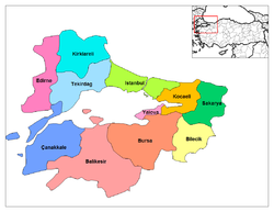
- Balıkesir Province
- Bilecik Province
- Bursa Province
- Çanakkale Province
- Edirne Province
- İstanbul Province
- Kırklareli Province
- Kocaeli Province
- Sakarya Province
- Tekirdağ Province
- Yalova Province
Geography
The Yıldız (Star) Mountains and Uludağ are in the Marmara Region. Islands in the Sea of Marmara are Marmara Island and Avşa.
See also
References
External links
- (Turkish) Golyaka Village, Bursa
|
|||||||
| This article about a Marmara Region of Turkey location is a stub. You can help Wikipedia by expanding it. |