Mount Damavand
| Damāvand | |
|---|---|
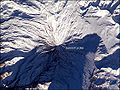
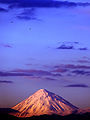
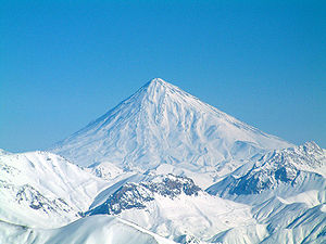 Damāvand in winter |
|
| Elevation | 5,610 m (18,406 ft) [1] |
| Prominence | 4,667 m (15,312 ft) Ranked 12th |
| Listing | Volcanic Seven Summits Country high point Ultra |
| Location | |
 Damāvand
|
|
| Range | Alborz |
| Geology | |
| Type | Stratovolcano |
| Last eruption | Unknown |
| Climbing | |
| First ascent | 905 by Abu Dolaf Kazraji[2] |
| Easiest route | Hike |
Mount Damāvand (Persian: دماوند ) also known as Donbavand, a potentially active volcano and the highest peak in Iran, has a special place in Persian mythology and folklore. Located in the middle Alborz Range, adjacent to Varārū, Sesang, Gol-e Zard and Mīānrūd, it is the highest point in the Middle East and the highest volcano in all of Asia. It is a potentially active volcano,[3] since there are fumaroles near the summit crater emitting sulfur, which were known to be active on July 6, 2007.[4]
The mountain is located near the southern coast of the Caspian Sea, in Āmol county, Māzandarān, 66 kilometres (41 miles) northeast of Tehran.
Contents |
Symbolism and mythology
Damavand is, as any cursory reading of Persian literature will indicate, the Mount Olympus of Persian mythology.[5]
Damāvand is the symbol of Iranian resistance against despotism and foreign rule in Persian poetry and literature. In Zoroastrian texts and mythology, the three-headed dragon Aži Dahāka was chained within Mount Damāvand, there to remain until the end of the world. In a later version of the same legend, the tyrant Zahhāk was also chained in a cave somewhere in Mount Damāvand after being defeated by Kāveh and Fereydūn. Persian poet Ferdowsi depicts this event in his masterpiece, the Shahnameh:
بیاورد ضحاک را چون نوند
به کوه دماوند کردش ببند
The mountain is said to hold magical powers in the Shahnameh. Damāvand has also been named in the Iranian legend of Arash as the location he fired his arrow to mark the Iran border. The famous poem Damāvand by Mohammad Taqī Bahār is also one fine example of the mountain's significance in Persian literature. The first verse of this poem reads:
ای دیو سپید پای در بند
Ay dīve sepīde pāī dar band,
Oh white demon with feet in chains
ای گنبد گیتی، ای دماوند
Ay gonbade gītī, ay Damāvand
Oh terrestrial dome, Oh Mount Damāvand
Mount Damavand is depicted on the reverse of the Iranian 10,000 rials banknote.[6]
Thermal springs

Mt Damavand has some thermal springs (Abe Garm Larijan)[7] with therapeutic qualities. These mineral hot springs are mainly located on the volcano's flanks and at the base, giving evidence of volcanic heat comparatively near the surface of the earth. While no historic eruptions have been recorded, hot springs at the base and on the flanks, and fumaroles and solfatara near the summit, indicate a hot or cooling magma body still present beneath the volcano, so that Damavand is a potentially active volcano.
The most important of these hot springs are located in Abe Garm Larijan in a village by the name Larijan in the district of Larijan in Lar Valley . The water from this spring is useful in the treatment of chronic wounds and skin diseases. Near these springs there are public baths with small pools for public use.
Routes to the summit

The best major settlement for mountain climbers is the new Iranian Mountain Federation Camp in Polour village, located on the south of the mountain.
There are at least 16 known routes[8] to the summit which have different difficulties. Some of them are very dangerous and requires rock climbing. The most popular route is the Southern Route which has step stamps and also a camp midway called Bargah Sevom Camp/Shelter[9] at 4220 m (about 13,845 ft). The longest route is the Northeastern and it takes two whole days to reach the summit starting from downhill village of Nāndal and a night stay at Takht-e Fereydoun (elevation 4300 m - about 13,000 ft), a two-story shelter. The western route is famous for its sunset view. Sīmorgh shelter in this route at 4100 m (about 13,500 ft) is a newly constructed shelter with two stories. There is a frozen waterfall/Icefall[10] (Persian name Ābshār Yakhī)about 12m tall and the elevation of 5100m is the highest fall in Iran and Middle East.
Geographical location
| Map of central Alborz | Peaks: | 1 `Alam Kūh |
|---|---|---|
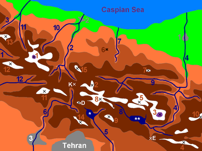
-25 to 500 m 500 to 1500 m 1500 to 2500 m 2500 to 3500 m 3500 to 4500 m 4500 to 5671 m
|
2 Āzād Kūh | 3 Damāvand |
| 4 Do Berar | 5 Do Khaharan | |
| 6 Ghal`eh Gardan | 7 Gorg | |
| 8 Kholeno | 9 Mehr Chal | |
| 10 Mīšīneh Marg | 11 Naz | |
| 12 Shah Alborz | 13 Sīālān | |
| 14 Tochal | 15 Varavašt | |
| Rivers: | 0 | |
| 1 Alamūt | 2 Chālūs | |
| 3 Do Hezār | 4 Harāz | |
| 5 Jājrūd | 6 Karaj | |
| 7 Kojūr | 8 Lār | |
| 9 Nūr | 10 Sardāb | |
| 11 Seh Hazār | 12 Shāh Rūd | |
| Cities: | 1 Āmol | |
| 2 Chālūs | 3 Karaj | |
| Other: | D Dīzīn | |
| E Emāmzādeh Hāšem | K Kandovān Tunnel | |
| * Latīān Dam | ** Lār Dam |
Nomination as National Heritage Site
An anthropologist of Mazandaran Cultural Heritage and Tourism Department, Touba Osanlou, has said that a proposal has been made by a group of Iranian mountaineers to register the highest peak in the Middle East, Mount Damavand as a national heritage site. Mazandaran Cultural Heritage and Tourism Department has accepted the proposal, the Persian daily Jam-e Jam reported. Osanlou noted that the Iranian Cultural Heritage and Tourism Organization is presently in the process of renaming an upcoming ancient festivity after Mount Damavand. "We have proposed Tirgan Festivity, Tabari Nowruz, to be named as Damavand National Day," he added. Tirgan Festivity is held in Amol County’s Rineh region in Mazandaran province.[11]
Gallery
 Foot of Damāvand |
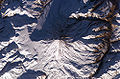 Summit Crater of Mt. Damāvand from space |
 Damāvand from space |
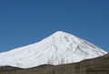
 Damāvand Mountain |
|
Damavand in winter |
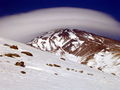
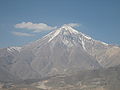 East View of Damāvand in October |
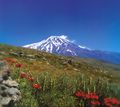
 Damāvand Mountain |
 Damaavand Mountain |
 Damaavand Mountain |
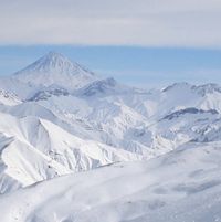 View of Damavand as seen from Dizin |
 |
.JPG) Damavand Peak from inside the car |
See also
- List of volcanoes in Iran
Notes
- ↑ The 5,610 metre height given here is from the Statistical Centre of Iran, which states that "the highest point in Iran is Mount Damāvand being 5,610 metres high". This elevation is consistent with SRTM data. A 2007 GPS measurement [1] reports a slightly higher elevations, 5623m, but also reports -17m for the nearby Caspian Sea despite its accepted -28m. This suggests that there is slight local geoid inaccuracy built into hand held GPS measurements in this area, and that the official Iranian elevation is accurate. An older elevation, 5,671 m, is not consistent with the above sources and there is no evidence that it is based on any modern measurement, although it is still the most frequently given elevation on the web.
- ↑ "SummitPost: Damavand". http://www.summitpost.org/mountain/rock/150400/damavand.html. Retrieved 2010-04-28.
- ↑ "Damavand". Global Volcanism Program, Smithsonian Institution. http://www.volcano.si.edu/world/volcano.cfm?vnum=0302-01-.
- ↑ "Volcanic Hole on Damavand". http://www.summitpost.org/image/309028/150400/volcanic-hole.html. Retrieved 2007-08-23.
- ↑ Milani, A. Lost Wisdom. 2004. Washington. ISBN 0934211906 p.67
- ↑ Central Bank of Iran. Banknotes & Coins: 10000 Rials. – Retrieved on 24 March 2009.
- ↑ http://damavandmt.blogspot.com/search/label/Thermal%20Spring
- ↑ [2]
- ↑ [3]
- ↑ [4]
- ↑ [5]
![[2]](http://www.sogol.com/WHP/IINFO/Ready INT/DAMAVAND MAP2.jpg)
External links
- Damavand Mountain Photo Gallery
- Damavand History
- "Damavand". Global Volcanism Program, Smithsonian Institution. http://www.volcano.si.edu/world/volcano.cfm?vnum=0302-01-.
- Damavand Mountaineering Guide
- Summit Post: Damavand
- Mount Damavand Climbing Tour
- Informative 2007 trip report
- Night-time panorama at The World at Night (TWAN)
|
|||||