Persian Gulf
| Persian Gulf | |
|---|---|
 |
|
| Location | Southwest Asia |
| Ocean type | Gulf |
| Primary sources | Sea of Oman |
| Basin countries | Iran, Iraq, Kuwait, Saudi Arabia, Qatar, Bahrain, United Arab Emirates and Oman (exclave of Musandam) |
| Max length | 989 km (615 mi) |
| Max width | (min) |
| Surface area | 251,000 km2 (97,000 sq mi) |
| Average depth | 50 m (160 ft) |
| Max depth | 90 m (300 ft) |
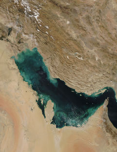
The Persian Gulf, in Southwest Asia, is an extension of the Indian Ocean located between Iran and the Arabian Peninsula.[1] Historically and commonly known as the Persian Gulf, this body of water is also controversially referred to as the Arabian Gulf or simply The Gulf by most Arab states[2], and Gulf of Basra by Turkey, although none of the latter three terms is recognized internationally.
The Persian Gulf was a focus of the 1980-1988 Iraq-Iran War, in which each side attacked the other's oil tankers. In 1991, the Persian Gulf again was the background for what was called the "Persian Gulf War" or the "Gulf War" when Iraq invaded Kuwait and was subsequently pushed back, despite the fact that this conflict was primarily a land conflict.
The Persian Gulf has many good fishing grounds, extensive coral reefs, and abundant pearl oysters, but its ecology has come under pressure from industrialization, and in particular, petroleum spillages during the recent wars in the region.
Contents |
Geography
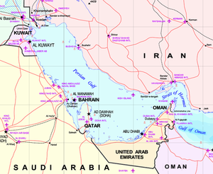
This inland sea of some 251,000 km² is connected to the Gulf of Oman in the east by the Strait of Hormuz; and its western end is marked by the major river delta of the Shatt al-Arab, which carries the waters of the Euphrates and the Tigris. Its length is 989 kilometres, with Iran covering most of the northern coast and Saudi Arabia most of the southern coast. The Persian Gulf is about 56 kilometres wide at its narrowest, in the Strait of Hormuz. The waters are overall very shallow, with a maximum depth of 90 metres and an average depth of 50 metres.
Countries with a coastline on the Persian Gulf are (clockwise, from the north): Iran, Oman (exclave of Musandam), United Arab Emirates, Saudi Arabia , Qatar on a peninsula off the Saudi coast, Bahrain on an island, Kuwait and Iraq in the northwest. Various small islands lie within the Persian Gulf, some of which are subject to territorial disputes by the states of the region.
Extent
The International Hydrographic Organization refers to the gulf as the "Persian Gulf (Gulf of Iran)", and it defines its southern limit as follows:[3]
The Northwestern limit of Gulf of Oman [A line joining Ràs Limah (25°57'N) on the coast of Arabia and Ràs al Kuh (25°48'N) on the coast of Iran (Persia)].
Oil and gas
The Persian Gulf and its coastal areas are the world's largest single source of crude oil and related industries dominate the region. Al-Safaniya, the world's largest offshore oilfield, is located in the Persian Gulf. Large gas finds have also been made with Qatar and Iran sharing a giant field across the territorial median line (North Field in the Qatari sector; South Pars Field in the Iranian sector). Using this gas, Qatar has built up a substantial liquified natural gas (LNG) and petrochemical industry.
The oil-rich countries (excluding Iraq) that have a coastline on the Persian Gulf are referred to as the Persian Gulf States. Iraq's egress to the gulf is narrow and easily blockaded consisting of the marshy river delta of the Shatt al-Arab, which carries the waters of the Euphrates and the Tigris Rivers, where the left (East) bank is held by Iran.
Etymology
In 550 B.C, the Achaemenid Empire established the first Persian Empire in Pars (Persis, or modern Fars) in the southwestern region of the Iranian plateau. Consequently in the Greek sources, the body of water that bordered this province came to be known as the Persian Gulf.[4]
Considering the historical background of the name Persian Gulf, Sir Arnold Wilson mentions in a book, published in 1928 that:
| “ | No water channel has been so significant as Persian Gulf to the geologists, archaeologists, geographers, merchants, politicians, excursionists, and scholars whether in past or in present. This water channel which separates the Iran Plateau from the Arabia Plate, has enjoyed an Iranian Identity since at least 2200 years ago.[1] | ” |
No written deed has remained since the era before the Persian Empire, but in the oral history and culture, the Iranians have called the southern waters: "Jam Sea", "Iran Sea", "Pars Sea".
During the years: 550 to 330 B.C. coinciding with sovereignty of the first Persian Empire on the Middle East area, especially the whole part of Persian Gulf and some parts of the Arabian Peninsula, the name of "Pars Sea" has been widely written in the compiled texts.[1]
In the travel account of Pythagoras, several chapters are related to description of his travels accompanied by Darius the Great, to Susa and Persepolis, and the area is described. From among the writings of others in the same period, there is the inscription and engraving of Darius the great, installed at junction of waters of Arabian Gulf (Ahmar Sea = Red sea) and Nile river and Rome river (current Mediterranean) which belongs to the 5th century BC where, Darius, the king of Achaemenid Empire has named the Persian Gulf Water Channel: Pars Sea (Persian Sea).[1]
Naming dispute
In the fifth century B.C., Darius the Great of the Achaemenid dynasty called the Persian Gulf "Draya; tya; haca; parsa: Aitiy", meaning, "The sea which goes from Persian"[5]. In this era, some of the Greek writers also called it "Persikonkaitas", meaning the Persian Gulf. Claudius Ptolemaues, the celebrated Greco-Egyptian mathematician/astronomer in the second century called it "Persicus Sinus" or Persian Gulf[6]. In the first century A.D., Quintus Curticus Rufus, the Roman historian, designated it "Aquarius Persico" – the Persian Sea[7]. Flavius Arrianus, another Greek historian, called it "Persiconkaitas" (Persian Gulf)[8].
During the Sassanian dynasty and the time of the Prophet Muhammad and the 4 caliphs, the name invariably used was the "Persian Sea"[9]. This was continued by the Ummayyads and Abbassids[9], while during the Ottomans used either "Persian Gulf" or "Persian Sea", however occasionally they called it "Khalij of Basra" or "Basra Kurfuzi", meaning the Gulf of Basra[9].
Among historians, travellers and geographers of the Islamic era, many of them writing in Arabic from the 9th to the 17th century, Ibn Khordadbeh[10], Ibn al-Faqih[11], Ibn Rustah[12], Sohrab[13], Ramhormozi[14], Abu Ishaq Ibrahim ibn Muhammad al-Farisi al Istakhri[15], Abu al-Hasan Ali ibn al-Husayn ibn Ali al-Mas'udi[16], Al-Mutahhar ibn Tahir al-Maqdisi(d. 966)[17], Ibn Hawqal[18], Al-Muqaddasi[19], Ibn Khaldun[20],Mohammad ibn Najub Bekiran[21], Abu Rayhan Biruni[22], Muhammad al-Idrisi[23], Yaqut al-Hamawi[24], Zakariya al-Qazwini[25], Abu'l-Fida[26], Al-Dimashqi[27], Hamdollah Mostowfi[28], Ibn al-Wardi[29], Al-Nuwayri[30], Ibn Batutta[31], Katip Çelebi and other sources[32] have used the terms "Bahr-i-Fars", "Daryaye-i-Fars", "Khalij al-'Ajami" and "Khalij-i Fars" (all of which translate into "Persian Gulf" or "Persian Sea").
Until the 1960s Arab countries used the term "Persian Gulf" as well[33][34] , however with the rise of Arab nationalism (Pan-Arabism) in the 1960s, most Arab states started adopting the term "Arabian Gulf" (in Arabic: الخلیج العربي al-ḫalīǧ al-ʻarabi) to refer to the waterway.[2][35],[36],[37]. However, this naming has not found much acceptance outside of the Arab world, and is not recognized by the United Nations[2][38][39][40] or any other international organization.[2][41]
The United Nations Secretariat on many occasions has requested that only "Persian Gulf" be used as the official and standard geographical designation for the body of water.[42] Historically, "Arabian Gulf" has been a term used to indicate the Red Sea.[1][43][44][45][46] At the same time, the historical veracity of the usage of "Persian Gulf" can be established from the works of many medieval historians.[1][47][48][49][50]
At the Twenty-third session of the United Nations in March-April 2006, the name "Persian Gulf" was confirmed again as the legitimate and official term to be used by members of the United Nations.[51]
History
Pre-Islamic era
For most of the history of human settlement in the Persian Gulf the southern side was ruled by nomadic tribes. During the end of fourth millennium BC the southern part of the Persian Gulf was dominated by the Dilmun civilization. For a long time the most important settlement on the southern coast of the Persian Gulf was Gerrha. In the second century the Lakhum tribe, who lived in Yemen, migrated north and founded the Lakhmid Kingdom along the southern coast. During the 7th century the Sassanid Empire conquered the whole of the Persian Gulf.
Between 625 BC and 226 AD the northern side was dominated by the Median, Achaemenid, Seleucid and Parthian empires. After the fall of the Parthian Empire, the Sassanid empire ruled the northern half and at times the southern half of the Persian Gulf. the Persian Gulf, along with the Silk Road was very important to trade in the Sassanid empire. Siraf was an ancient Sassanid port that was located on the north shore of the Persian Gulf in what is now the Iranian province of Bushehr.
Colonial era
Portuguese expansion into the Indian Ocean in the early sixteenth century following Vasco da Gama's voyages of exploration saw them battle the Ottomans up the coast of the Persian Gulf. In 1521, a Portuguese force led by commander Antonio Correia invaded Bahrain to take control of the wealth created by its pearl industry. IIn April 29 of 1602, Shāh Abbās, the Persian emperor of Safavid Persian Empire expelled the Portuguese from Bahrain.[52][52], and that date is commemorated as National Persian Gulf day in Iran[53]. With the support of the British fleet, in 1622 'Abbās took the island of Hormuz from the Portuguese: much of the trade was diverted to the town of Bandar 'Abbās which he had taken from the Portuguese in 1615 and had named after himself. The Persian Gulf was therefore opened by Persians to a flourishing commerce with Portuguese, Dutch, French, Spanish and British merchants, which were granted particular privileges.
From 1763 until 1971, the British Empire maintained varying degrees of political control over some Persian Gulf states, including the United Arab Emirates (originally called the "Trucial Coast States") and at various times Bahrain, Kuwait, Oman, and Qatar through the British Residency of the Persian Gulf.
The United Kingdom maintains a high profile in the region; in 2006, over 1 million Britons visited Dubai alone.[54]
Wildlife
Mangroves in the Persian Gulf, which are thought to require tidal flow and a combination of fresh and salt water, are nurseries for crabs, small fish, and insects - and the birds that eat them.[55]
See also
- Cradle of civilization
- Deluge (prehistoric)
- Gulf of Aden
- Arab cuisine of the Persian Gulf
- Gulf Railway
References
- ↑ 1.0 1.1 1.2 1.3 1.4 1.5 Working Paper No. 61, UNITED NATIONS GROUP OF EXPERTS ON GEOGRAPHICAL NAMES, dated March 28, April 4, 2006 ([1]); accessed February 09, 2007
- ↑ 2.0 2.1 2.2 2.3 Niusha Boghrati, Omission of 'Persian Gulf' Name Angers Iran, World Press.com, dated December 28, 2006 (LINK)
- ↑ "Limits of Oceans and Seas, 3rd edition". International Hydrographic Organization. 1953. http://www.iho-ohi.net/iho_pubs/standard/S-23/S23_1953.pdf. Retrieved 7 February 2010.
- ↑ Touraj Daryaee, The Persian Gulf Trade in Late Antiquity, Journal of World History, Vol. 14, No. 1., March 2003, (LINK); accessed February 09, 2007
- ↑ Roland G. Kent, "Old Persian Texts", Journal of Near Eastern Studies, Bol. I, Oct. 1942, no. 4., pg 419
- ↑ See geography of Claudius Ptolemy translated by Edward L. Stevenson; also sited in Sir Arnold T. Wilson, "The Persian Gulf", (London: 1928), pg 3 and pg 43
- ↑ Histoire d’Alexandre le Grand par Quinte Curce, traduction en Francais, Tom II (Paris: 1834), pg 184
- ↑ Flavius Arrianus, "History of Alexandre and Indica" with an English translation by E. Lliff Robinson (London: 1949), the Loeb Classical Library vol. II, pp. 414-417
- ↑ 9.0 9.1 9.2 Mehr, Farhang (1997), "A colonial legacy: The dispute over the islands of Abu Musa, and the Greater and Lesser Tumbs", University Press of America
- ↑ "Al-Massalek wa al-Mamalek", Leiden edition, 1889. Pg 233
- ↑ The abrdiged "Al-Buldan", Leiden, 1885, pg 8
- ↑ Ibn Rustah, Kitāb al-A'lāk an-Nafīsa, ed. M. J. De Goeje, Bibliotheca Geographorum Arabicorum [BGA], Leiden, E. J. Brill, 1891/1892. Pg 81
- ↑ Ajayeb al-Aqalim al-Saba ila Nehayate al-Mara, (Vienne: 1929), pg 59. He was a Persian geographer who lived in the 9th century A.D.
- ↑ Nakhoda Bozorg ibn Shahriyar Ramhormozi was another Persian geographer of the classical Islamic era, "Ajayeb al-Hind", ed: M. Davis, Leiden 1886, pg. 41
- ↑ "Massalek al-Mamalek", ed.: De M.J. Goeje, Leiden 1927, pg 28
- ↑ "Muruj adh-dhahab wa ma'adin al-jawhar (The Meadows of Gold and Mines of Gems)", English Translation by Aloys Sprenger, Vol I, (London: 1841), p. 259
- ↑ al-Bad’ wa-l Tarikh, (Paris: 1907) Tom IV, pg 58.
- ↑ "The Oriental Geography of Ebn Hawkal", Translated by Sir Williams Ouseley (London: 1800) p. 62; "Surat al-Arḍ"(Leiden 1938), Vol I, pg 42.
- ↑ Ahsan al-Taqasim fi Ma’rifat al-Aqalim. Ed: De A.J. Goeje, (Leiden 1906), pg 17.
- ↑ بحر فارس فی کتاب تاريخ ابن خلدون الجزء الأول ص ( 2 من 258 ) وكذلك يقولون في تبع الآخر وهو أسعد أبو كرب وكان على عهد يستأنف من ملوك الفرس الكيانية إنه ملك الموصل وأذربيجان ولقي الترك فهزمهم وأثخن ثم غزاهم ثانية وثالثة كذلك وإنه بعد ذلك أغزى ثلاثة من بنيه بلاد فارس وإلى بلاد الصغد ..... وذلك أن ملك التبابعة إنما كان بجزيرة العرب وقرارهم وكرسيهم صنعاء اليمن. وجزيرة العرب يحيط بها البحر من ثلاث جهاتها: فبحر الهند من الجنوب وبحر فــارس الهابط منه إلى البصرة من المشرق وبحر السويس الهابط منه إلى السويس من أعمال مصر من جهة المغرب كماتراه في مصور الجغرافيا. فلا يجد السالكون من اليمن إلى المغرب طريقاً من غير السويس. تاريخ ابن خلدون الجزء الأول ( 3 من 258 ) والبحر الثاني من هذا البحر الحبشي ويسمى الخليج الأخضر يخرج ما بين بلاد السند والأحقاف من اليمن ويمر إلى ناحية الشمال مغرباً قليلاً إلى أن ينتهي إلى الأبلة من سواحل البصرة في الجزء السادس من الإقليم الثاني على أربعمائة فرسخ وأربعين فرسخاً من مبدئه ويسمى بحر فـــارس. وعليه من جهة الشرق سواحل السند ومكران وكرمان وفارس والأبلة عند نهايته ومن جهة الغرب سواحل البحرين واليمامة وعمان والشحر والأحقاف عند مبدئه. وفيما بين بحر فارس والقلزم جزيرة العرب كأنها داخلة من البر في البحر يحيط بها البحر الحبشي من الجنوب وبحر القلزم من الغرب وبحر فارس من الشرق وتفضي إلى العراق فيما بين الشام والبصرة على ألف وخمسمائة ميل بينهما. وهنالك الكوفة والقادسية وبغداد وإيوان كسرى والحيرة. ووراء ذلك أمم الأعاجم من الترك والخزر وغيرهم. وفي جزيرة العرب بلاد الحجاز في جهة الغرب منها وبلاد اليمامة والبحرين وعمان جهة الشرق منها وبلاد اليمن في قالوا: وفي هذا المعمور بحر أخر منقطع من سائر البحار في ناحية الشمال بأرض الديلم يسمى بحر جرجان وطبرستان طوله ألف ميل في عرض ستمائة ميل في غربيه أذربيجان والديلم وفي شرقيه أرض الترك وخوارزم وفي جنوبيه طبرستان وفي شماليه أرض الخزر واللان. هذه جملة البحار المشهورة التي ذكرها أهل الجغرافيا........ ....... وفي الجزء السادس من هذا الإقليم فيما بين البحرين الهابطين من هذا البحر الهندي إلى جهة الشمال وهما بحر قلزم وبحر فارس وفيما بينهما جزيرة العرب. وتشتمل على بلاد اليمن وبلاد الشحر في شرقيها على ساحل هذا البحر الهندي وعلى بلاد الحجاز واليمامة.في كتاب أحسن التقاسيم في معرفة الأقاليم المقدسي البشاري هي فی
- ↑ "Jahan Nama", quoted by Mohammad Javad Mashkoor in an article titled "Nam-i Khalij Fars" in the proceeding of the "Seminar on Khalij-e-Fars" (Tehran: 1964), Vol I. p. 44. Bekiran lived in the 11th century A.D.
- ↑ "Al-Tafhim le-awa’el Sena al-Tanjim" ed.: Jalal al-Din Homai (Tehran: 1318 Hijri Sola Calendar), pg 167. Also in "Qanun Masudi"(Heydarabad, 1955), Vol. II. Pg 558. ابوريحان بيرونی ( 440 ق.) فی کتاب التفهيم: بحر پارس ـ دريای پارس ـ ابوريحان بيرونی فی کتاب قانون المسعودی: دريای فارس ـ ابوريحان بيرونی فی کتاب تحديد نهايات الامانی: بحر فارس
- ↑ "Geographic d’Edirisi" traduite de l’Arabe en Francais par P. Amedee Jaulert (Recueil des voyages et des memoires publiees par la Societe de Geographie), (Paris: 1840), Vols. VI and VI. "Nuzhat al-Mushtaq fi Ikhtraq al-Afar", (Rome : 1878). Pg 9
- ↑ "mu’jam al-Buldan",(Cairo: 1906), Vol. 2, pg 68. ياقوت حموی ( 626 ق.) فی کتاب المعجم البلدان: بحر فارس
- ↑ "Athar al-Bilad" (Gutingen: 1848), pg 104. زکريای قزوينی ( 682 ق.) فی کتاب آثار البلاد: بحر فارس ـ زکريای قزوينی فی کتاب العجايب المخلوقات: بحر فارس
- ↑ "Taqwim al-Buldan", Geographie d’Aboulfeda traduite de l’Arab par M. Reinaud, 2 Vols. (Paris: 1848), Vol 1, pg 23. ابوالفداء ( 732 ق.) فی کتاب التقويم البلدان: بحر فارس
- ↑ Quoted also in Mohammad Javad Mashkoor in an article titled "Nam-i Khalij Fars" in the proceeding of the "Seminar on Khalij-e-Fars" (Tehran: 1964). Pg 46. انصاری الدمشقی ( 727 ق.) فی کتاب النخبة الدهر: بحر فارس
- ↑ "Nuzhat al-Qolub", ed: Mohammad Dabir Sayaqi, (Tehran: 1336 Hijri Solar Year), pg 164. حمدالله مستوفی قزوينی ( 740 ق.) فی کتاب النزهة القلوب: بحر فارس
- ↑ "Kharida al-Ajayeb", Quoted also in Mohammad Javad Mashkoor in an article titled "Nam-i Khalij Fars" in the proceeding of the "Seminar on Khalij-e-Fars" (Tehran: 1964). Pg 47. ابوحفص ابن الوردی ( 749 ق.) فی کتاب خريده العجايب: بحر فارس
- ↑ Quoted also in Mohammad Javad Mashkoor in an article titled "Nam-i Khalij Fars" in the proceeding of the "Seminar on Khalij-e-Fars" (Tehran: 1964). Pg 46.شهاب الدين احمد نويری ( 733 ق.) فی کتاب نهاية الارب: خليج فارس
- ↑ "The Travels of Ibn Babutta", translated from the abrdiged Arabic MMS of Cambridge by the Rev. Samuel Lee(Cambridgde: 1824), pg 56
- ↑ ابن فقيه فی کتاب البلدان (تأليف 279 ق.): اطلق علیها الاسم : بحر فارس ـ ابن رسته فی کتاب الاعلاق النفيسه (تأليف 290 ق.): تسمیها بالخليج الفارسی ـ سهراب (قرن ثالث هجری) فی کتاب العجايب الاقاليم السبعه: ت= بحر فارس ـ ابن خردادبه ( 300 ق.) فی کتاب المسالک الممالک: ت = بحر فارس ـ بزرگ بن شهريار فی کتاب العجايب الهند (تأليف 342 ق.): بحر فارس ـ اصطخری ( 346 ق.) فی الکتاب المسالک الممالک: بحر فارس ـ اصطخری فی کتاب الاقاليم: بحر فارس ـ مسعودی ( 346 ق.) فی کتاب المروج الذهب: بحر فارس ـ مسعودی فی کتاب التنبيه والاشراف: بحر الفارس ـ ابن مطهر فی کتاب البدء والتاريخ (تأليف 355 ق.): خليج الفارس ـ ابوريحان بيرونی ( 440 ق.) فی کتاب التفهيم: بحر پارس ـ دريای پارس ـ ابوريحان بيرونی فی کتاب قانون المسعودی: دريای فارس ـ ابوريحان بيرونی فی کتاب تحديد نهايات الامانی: بحر فارس ـ ابن حوقل فی کتاب صورة الارض (تأليف 367 ق.): بحر فارس ـ مؤلف الحدود العالم من المشرق الی المغرب (تأليف 372 ق.): خليج فارس ـ دريای پارس ـ مقدسی فی کتاب احسن التقاسيم فی معرفة الاقاليم (تأليف 375 ق.): بحر فارس ـ محمد بن نجيب فی کتاب جهان نامه (تأليف قرن چهارم): بحر پارس ـ ابن بلخی فی کتاب فارسنامه (تأليف حدود 500 ق.): بحر فارس ـ طاهر مروزی فی کتاب الطبايع الحيوان (تأليف حدود 514 ق.): الخليج الفارس ـ شريف ادريسی ( 560 ق.) فی کتاب النزهة المشتاق: بحر فارس ـ ياقوت حموی ( 626 ق.) فی کتاب المعجم البلدان: بحر فارس ـ زکريای قزوينی ( 682 ق.) فی کتاب آثار البلاد: بحر فارس ـ زکريای قزوينی فی کتاب العجايب المخلوقات: بحر فارس ـ انصاری الدمشقی ( 727 ق.) فی کتاب النخبة الدهر: بحر فارس ـ ابوالفداء ( 732 ق.) فی کتاب التقويم البلدان: بحر فارس ـ شهاب الدين احمد نويری ( 733 ق.) فی کتاب نهاية الارب: خليج فارس ـ حمدالله مستوفی قزوينی ( 740 ق.) فی کتاب النزهة القلوب: بحر فارس ـ ابوحفص ابن الوردی ( 749 ق.) فی کتاب خريده العجايب: بحر فارس ـ ابن بطوطه ( 777 ق.) فی الکتاب مشهور الرحله ابن بطوطه : بحر فارس ـ قلقشندی (درگذشته 821 ق.) فی کتاب صبح الاعشی: بحر فارس ـ حاجی خليفه ( 1067 ق.) فی کتاب جهان نما (ترکی): بحر فارس ـ شمس الدين محمد سامی فی قاموس الاعلام (قرن سيزدهم هجری): خليج بصره ـ البستانی فی دايرة المعارف البستانی (طبع 1883 م.): الخليج العجمی و ایضا سجلت و وصفت الخلیج الفارسی فی کتب : 1ـ آثار البلاد و اخبار العباد ـ تالیف ابوعبدالله زكريا بن محمد بن محمود القزويني ـ طبع بيروت 1960. 2ـ احسن التقاسيم في معرفة الاقاليم ـ تالیف شمس الدين ابوعبدالله محمدبن احمدبن ابوبكر الشامي مقدسي، معروف به البشاري، ـ ليدن 1960 (يطلب من مكتبة المثني ببغداد). 4ـ الاعلاق النفيسه ـ تالیف ابوعلي احمد بن عمر، معروف به ابن رسته، طبع ليدن 1981 ميلادي. . 8ـ تاريخ التمدن الاسلامي ـ تأليف جرجي زيدان ـ طبع القاهره 1935 ـ جلد دوم. 9ـ التفهيم لاوائل صناعة التنجيم ـ ابوريحان بيروني خوارزمي ـ تصحيح جلال همايي 1318 شمسي. 10ـ حياة الحيوان الكبري ـ شيخ كمال الدين الدميري، قاهره 1311 هجري. 11ـ خريدة العجائب و فريدة الغرائب ـ تالیف ابو حفض زيدالدين عمر مظفر، معروف به ابن الوردي ـ چاپ قاهره 1303 هجري. 18ـ صبح الاعشي في صناعة الانشاء ـ ابي العباس احمدبن علي بن احمد القلقشندي . قاهره 1913 تا 1920 جلد سوم. 19ـ صورة الارض، تالیف ابوالقاسم محمدبن حوقل، ليدن 1938 ، جلد اول. 20ـ طبايع الحيوان ـ تالیف شرف الزمان طاهر مروزي ـ طبع لندن 1942 . 21ـ عجائب الاقاليم السبعة الي نهاية المعمارة ـ تالیف سهراب ـ وين 1929 . 22ـ العراق ـ تأليف سيد عبدالرزاق الحسني ـ صيدا 1956 . 23ـ علم الخرائط ـ تأليف دكتر محمد عبدالكريم صبحي، قاهره 1966 . 24ـ قاموس الاعلام ـ تالیف شمس الدين محمد سامي، استانبول 1306 هجري. 25ـ قانون مسعودي ـ تالیف ابوريحان بيروني الخوارزمي، حيدرآباد دكن 1955 . 26ـ قصة الحضارة ـ تأليف ويل دورانت ـ ترجمه به عربي از دكتر زكي نجيب محمود، قاهره 1965 . 27ـ لطايف اللغات ـ عبداللطيف بن عبدالله ـ نسخهٌ خطي. 28ـ مختصر البلدان ـ ابوبكر احمدبن محمد، معروف به ابن الفقيه (279 هجري)، ليدن 1885) يطلب من مكتبة المثني ببغداد). 29ـ مراصد الاطلاع ـ علي محمد البجاوي ـ طبع 1954 جزء اول. 30ـ المسالك و الممالك ـ ابواسحق ابراهيم الاصطخري، ليدن 1889 . 31ـ الموسوعة العربية الميسرة ـ تأليف صبحي عبدالكريم، ترجمه الی عربي من محمد شفيق غربال، قاهره 1965 . 32ـ تطور الخط العربي ـ تأليف ناجي زيدالدين ـ طبع بغداد 1968 . 33ـ معجم البلدان ـ شهاب الدين ابوعبدالله ياقوت بن عبدالله حموي رومي، قاهره 1906 . 34ـ المنجد (معجم)، ـ بيروت 1966 . 35ـ نخبة الدهر في عجائب البر و البحر ـ نوشتهٌ شمس الدين ابوعبدالله محمد بن ابي طالب الانصاري الدمشقي الصوفي ـ چاپ لايپزيك 1923 . 36ـ نزهة القلوب ـ حمدالله بن احمد بن ابي بكر مستوفي قزويني ـ 1928 ميلادي. 37ـ نزهة المشتاق ـ ابوعبدالله، محمدبن عبدالله معروف به شريف الادريسي، رم 1878 . 38ـ نهاية الارب في فنون الادب ـ تأليف شهاب الدين احمد عبدالوهاب النري ـ قاهره 1923
- ↑ Picture of Gamal Abdel Nasser's handwritten letter, using the term Persian Gulf
- ↑ Picture of 1952 Saudi Arabian ARAMCO map using the name Persian Gulf
- ↑ (The Persian Gulf at the Millennium: Essays in Politics, Economy, Security, and Religion edited by Gary G. Sick, Lawrence G. Potter, pg 8)"As recognized by the United States Board on Geographic names, the name of the body of water that lies between Iran and the Arab states of the Gulf Cooperation Council is the Persian Gulf. For political reasons, Arabs often refer to it as the Arab or Arabian Gulf "
- ↑ Eilts, Hermann F. "Security Considerations in the Persian Gulf." International Security :Vol. 5, No. 2. (Autumn, 1980), pp. 79-113. "The Arab-Iranian nomenclatural controversy over the Gulf, which was so bitter in the late 50s and early 60s, was a by-product of the late President Nasser of Egypt's brand of Arab nationalism ... 'Arabian Gulf' is in fact a recent Arab appellation for that body of water..." )
- ↑ Bosworth, C. Edmund. "The Nomenclature of the Persian Gulf." Pages xvii-xxxvi in Alvin J. Cottrell (ed.), The Persian Gulf States: A General Survey. Baltimore: Johns Hopkins University Press, 1980.) (pg xxxiii).. Excerpt: Not until the early 1960s does a major new development occur with the adoption by the Arab states bordering on the Gulf of the expression al-Khalij al-Arabi as weapon in the psychological war with Iran for political influence in the Gulf; but the story of these events belongs to a subsequent chapter on modern political and diplomatic history of the Gulf."
- ↑ UN Map (LINK)
- ↑ UN Map of Iran([2])
- ↑ UN Map of Western Asia, ([3])
- ↑ . The Persian Gulf at the Millennium: Essays in Politics, Economy, Security, and Religion edited by Gary G. Sick, Lawrence G. Potter, pg 8
- ↑ ([4])
- ↑ Working Paper No. 61, UNITED NATIONS GROUP OF EXPERTS ON GEOGRAPHICAL NAMES, dated March 28, April 4, 2006, p.2 ([5])
- ↑ Hecataeus (472 to 509 B.C.) can be stated where Persian Gulf and Arabian Gulf (Red Sea) have been clearly shown.
- ↑ Also a map has remained from Herodotus, the great Greek historian (425-484 B.C.) which introduces Red Sea as the Arabian Gulf
- ↑ In the world map of Diseark (285-347 B.C.) too, Persian Gulf and Arabian Gulf have been clearly distinct.
- ↑ Many maps and deeds prepared up to the 8th century by the historians such as Arrian, Hecataeus, Herodotus, Hiparek, Claudius Batlamious, Krats Malous.
- ↑ Arriann, "Alexander Fleet in the Persian Gulf", in Anabasis Alexandri: Book VIII (INDICA)
- ↑ In the Islamic period, Khwārizmī, Abou Yousef Eshagh Kandi, Ibn Khordadbeh, Batani (Harrani), Mas'udi, Balkhi, Estakhri, Ibn Houghal, Aboureyhan Birouni and others, mention that there is a wide sea at south of Iran named "Pars Sea", "Pars Gulf", "Fars Sea", "Fars Gulf", "Bahre Fars", "Sinus Persicus" and "Mare Persicum" and so on.
- ↑ In a book, named "Persilus Aryateria", the Greek traveller of the 1st century A.D. has called the Red Sea as Arabian gulf; the Indian ocean has been named Aryateria Sea; the waters at Oman Coast is called Pars Sea; Barbarus region (between Oman and Yemen coast are called belonging to Pars, and the Gulf located at south side of Iran is named: Persian Gulf. By describing the water body, the life of Persians living at both sides have also been confirmed.
- ↑ Working Paper No. 61, UNITED NATIONS GROUP OF EXPERTS ON GEOGRAPHICAL NAMES, dated March 28, April 4, 2006, p.2 ([6]).
- ↑ 52.0 52.1 Juan R. I. Cole, "Rival Empires of Trade and Imami Shiism in Eastern Arabia, 1300-1800", p. 186, through JSTOR. [7]
- ↑ Iran daily, Retrieved on 26 February 2009.
- ↑ Peter Beaumont, "Blair was dangerously off target in his condemnation of Iran", The Guardian, December 24, 2006.
- ↑ Jim Krane (2006-07-03). "Development in Persian Gulf Threatens Wildlife". Discovery Channel. http://dsc.discovery.com/news/2006/07/03/gulfwildlife_pla.html?category=earth&guid=20060703160030. Retrieved 30 June 2008.
External links
- Persian Gulf, Encyclopedia Iranica
- The Persian Gulf, Information, history and resources of the Persian Gulf
- The Portuguese in the Arabian peninsula and in the Persian Gulf
- Persian Gulf Region
- UN GEGN – Historical, Geographical and Legal Validity of the Name: Persian Gulf
- Persian Gulf Studies Website
|
||||||||||||||||||||