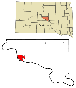
Pierre, South Dakota
| Pierre, South Dakota | |
|---|---|
| — City — | |
 |
|
| Coordinates: | |
| Country | United States |
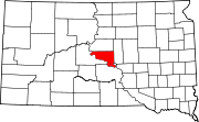
| State | South Dakota |
| County | Hughes |
| Founded | 1880 |
| Incorporated | 1883[1] |
| Government | |
| - Mayor | Laurie Gill |
| Area | |
| - Total | 13.0 sq mi (33.7 km2) |
| - Land | 13.0 sq mi (33.7 km2) |
| - Water | 0.0 sq mi (0.0 km2) 0.08% |
| Elevation | 1,453 ft (442 m) |
| Population (2000) | |
| - Total | 13,876 |
| - Density | 1,065.8/sq mi (411.5/km2) |
| Time zone | Central (UTC-6) |
| - Summer (DST) | Central (UTC-5) |
| ZIP code | 57501 |
| Area code(s) | 605 |
| FIPS code | 46-49600[2] |
| GNIS feature ID | 1266887[3] |
| Website | www.pierre.sd.gov |
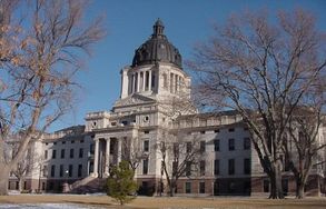
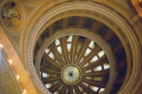
The city of Pierre (pronounced /ˈpɪər/, PEER[4]) is the capital of the U.S. state of South Dakota and the county seat of Hughes County.[5] The population was 13,876 at the 2000 census, making it the second least populous state capital after Montpelier, Vermont. Founded in 1880 on the Missouri River opposite Fort Pierre, Pierre has been South Dakota's capital since it gained statehood on November 11, 1889, having been chosen for its location in the geographic center of the state. Fort Pierre itself was named after Pierre Chouteau, Jr., an American fur trader of French-Canadian origin. It is also a major statewide transportation hub and is famous for its memorial hall.
Pierre is the principal city of the Pierre Micropolitan Statistical Area, which includes all of Hughes and Stanley counties.
Contents |
Geography
Pierre is located at (44.367966, −100.336378) [6].
According to the United States Census Bureau, the city has a total area of 13.0 square miles (33.7 km²), of which 13.0 square miles (33.7 km²) is land and 0.08% is water.
Pierre lies on rough river bluffs overlooking the Missouri River. Many of these bluffs are strewn with large boulders. It is a few miles away from Lake Oahe, one of the largest manmade lakes in the world and a very popular fishing destination.
The climate in Pierre consists of cold, sometimes harsh, winters and very warm to hot summers. The average highs and lows are 28°F/3°F for January and 89°F/62°F in July. The warmest temperature ever recorded in Pierre was 117°F (47.2°C), set on July 15, 2006. The coldest recorded temperature was −35°F (−37.2°C) on February 9, 1994.
| Monthly Normal and Record High and Low Temperatures | ||||||||||||
| Month | Jan | Feb | Mar | Apr | May | Jun | Jul | Aug | Sep | Oct | Nov | Dec |
|---|---|---|---|---|---|---|---|---|---|---|---|---|
| Rec High °F (°C) | 68 (20) | 75 (23.4) | 87 (30.5) | 98 (36.6) | 105 (40.5) | 112 (44.4) | 117 (47.2) | 114 (45.5) | 108 (42.2) | 98 (36.6) | 80 (26.6) | 70 (21.1) |
| Norm High °F (°C) | 28 (-2.2) | 35 (1.6) | 45 (7.2) | 60 (15.5) | 71 (21.6) | 81 (27.2) | 89 (31.6) | 88 (31.1) | 77 (25) | 62 (16.6) | 43 (6.1) | 32 (0) |
| Norm Low °F (°C) | 8 (-13.3) | 14 (-10) | 24 (-4.4) | 35 (1.6) | 46 (7.7) | 56 (13.3) | 62 (16.6) | 60 (15.5) | 49 (9.4) | 37 (2.7) | 23 (-5) | 12 (-11.1) |
| Rec Low °F (°C) | -33 (-36.1) | -35 (-37.2) | -19 (-28.3) | 4 (-15.5) | 22 (-5.5) | 35 (1.6) | 42 (5.5) | 39 (3.8) | 21 (-6.1) | 4 (-15.5) | -18 (-27.7) | -31 (-35) |
| Precip in. (mm) | 0.52 (13.2) | 0.54 (13.7) | 1.19 (30.2) | 2.02 (51.3) | 3.14 (79.7) | 3.49 (88.6) | 2.75 (69.8) | 1.86 (47.2) | 1.55 (39.4) | 1.64 (41.6) | 0.70 (17.8) | 0.48 (12.2) |
| Source: Weather.com [1] | ||||||||||||
Demographics
As of the census[2] of 2000, there were 13,876 people, 5,567 households, and 3,574 families residing in the city. The population density was 1,065.8 people per square mile (411.5/km²). There were 5,949 housing units at an average density of 457.0/sq mi (176.4/km²). The racial makeup of the city was 88.91% White, 0.20% African American, 8.56% Native American, 0.46% Asian, 0.02% Pacific Islander, 0.29% from other races, and 1.56% from two or more races. Hispanics or Latinos of any race were 1.25% of the population.
There were 5,567 households, out of which 32.9% had children under the age of 18 living with them, 51.6% were married couples living together, 9.5% had a female householder with no husband present, and 35.8% were non-families. 31.5% of all households were made up of individuals, and 10.7% had someone living alone who was 65 years of age or older. The average household size was 2.35, and the average family size was 2.96.
In the city the population was spread out, with 27.2% under the age of 18, 6.5% from 18 to 24, 28.6% from 25 to 44, 23.6% from 45 to 64, and 14.1% who were 65 years of age or older. The median age was 38 years. For every 100 females, there were 90.5 males. For every 100 females age 18 and over, there were 85.4 males.
The median income for a household in the city was $42,962, and the median income for a family was $52,144. Males had a median income of $32,969 versus $22,865 for females. The per capita income for the city was $20,462. About 5.5% of families and 7.8% of the population were below the poverty line, including 7.9% of those under age 18 and 9.2% of those age 65 or over.
Transportation
Airlines serving Pierre Regional Airport provide non-stop flights to Denver, Watertown, and Brookings, with continuing service to Minneapolis-St. Paul from Watertown.
The nearest interstate highway is Interstate 90, which is about 34 miles south of Pierre via U.S. Highway 83. Pierre is one of only five state capitals not served by an interstate highway. Dover, Delaware; Jefferson City, Missouri; Carson City, Nevada; and Juneau, Alaska, are the other four state capitals with this distinction.
Media
AM Radio
- KGFX (AM) 1060, (Country Music)
- KCCR AM 1240, (Adult Contemporary)
FM Radio
- KGFX-FM 92.7, (Adult Contemporary)
- KPLO-FM 94.5, (Country Music)
- KLXS FM 95.3, (Classic Hits)
- KJBI FM 100.1, (Classic Hits)
Television
The Capital Journal is the local newspaper.
Notable natives
- Floyd Bannister was a pitcher in Major League Baseball.
- Ernest O. Lawrence, physicist and Nobel Laureate
- M. Michael Rounds, Governor of South Dakota
References
- ↑ William D. Halsey, ed (1976). "Pierre". Collier's Encyclopedia. 19. New York: Macmillan Educational Corporation. pp. 42–43.
- ↑ 2.0 2.1 "American FactFinder". United States Census Bureau. http://factfinder.census.gov. Retrieved 2008-01-31.
- ↑ "US Board on Geographic Names". United States Geological Survey. 2007-10-25. http://geonames.usgs.gov. Retrieved 2008-01-31.
- ↑ "Broadcast Pronunciation Guide and South Dakota Pronunciations". Associated Press. http://www.ap.org/southdakota/prono.html. Retrieved 2009-11-10.
- ↑ "Find a County". National Association of Counties. http://www.naco.org/Template.cfm?Section=Find_a_County&Template=/cffiles/counties/usamap.cfm. Retrieved 2008-01-31.
- ↑ "US Gazetteer files: 2000 and 1990". United States Census Bureau. 2005-05-03. http://www.census.gov/geo/www/gazetteer/gazette.html. Retrieved 2008-01-31.
External links
- Pierre Chamber of Commerce
- Pierre city government official web site
- The Capital Journal - local newspaper
- Rawlins Municipal Library - public library
|
||||||||||||||
|
||||||||||||||||||||