SOCCSKSARGEN
| Region XII SoCCSKSarGen |
|
|---|---|
| — Region — | |
 |
|
| Country | Philippines |
| Island group | Mindanao |
| Regional center | Koronadal City, South Cotabato |
| Area | |
| - Total | 22,466 km2 (8,674.2 sq mi) |
| Population (2007) | |
| - Total | 3,829,081 |
| - Density | 170.4/km2 (441.4/sq mi) |
| Time zone | PST (UTC+8) |
| Provinces | 4 |
| Cities | 5 |
| Municipalities | 45 |
| Barangays | 1,194 |
| Cong. districts | 6 |
| Languages | English, Tagalog, Cebuano, Tboli, Blaan, Cotabato Manobo, Tagabanwa, others |
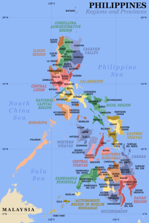
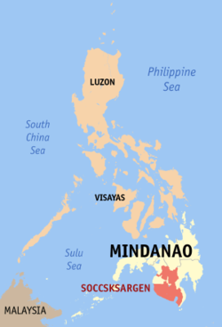
SOCCSKSARGEN[1] (pronounced [sokˈsardʒɛn]) is a region of the Philippines, located in central Mindanao, and is officially designated as Region XII. The name is an acronym that stands for the region's four provinces and one of its cities: South Cotabato, Cotabato, Sultan Kudarat, Sarangani and General Santos City. The regional center is Koronadal City located in the province of South Cotabato.[2] Cotabato City, though geographically within the boundaries of the province of Maguindanao, itself is part of SOCCSKSARGEN, and is independent of that province. Maguindanao province is a part of another special region called the ARMM which has its seat in Cotabato City. SOCCSKSARGEN and the province of Maguindanao were once part of the original Cotabato province.
Contents |
Geography
The region has extensive coastlines, valleys and mountain ranges. Known for its river system, the region is the catch basin of Mindanao. The system is a rich source of food, potable water and energy production. Cotabato contains the Rio Grande de Mindanao, which is the longest river in Mindanao and the second longest in the Philippines.
The region used to be named Central Mindanao. Prior to the creation of the Autonomous Region in Muslim Mindanao, these provinces comprised the region:
With the creation of ARMM, Lanao del Sur (excluding Marawi City) and Maguindanao (excluding Cotabato City) were removed from the region, leaving Lanao del Norte, North Cotabato and Sultan Kudarat, and Marawi City and Cotabato City as constituent provinces and cities. Lanao del Norte was later transferred to Northern Mindanao, while Marawi City became part of the ARMM.
With the addition of South Cotabato and Sarangani, transferred from Southern Mindanao, the region was renamed as SOCCSKSARGEN. The "Central Mindanao" name lives on as a description to the provinces populated by Muslim Filipinos.
Political Divisions
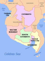
| Province/City | Capital | Population (2000) |
Area (km²) |
Pop. density (per km²) |
|---|---|---|---|---|
| Cotabato | Kidapawan City | 958,643 | 6,565.9 | 146.0 |
| Sarangani | Alabel | 410,622 | 2,980.0 | 137.8 |
| South Cotabato | Koronadal City | 690,728 | 3,996.1 | 172.9 |
| Sultan Kudarat | Isulan | 586,505 | 4,714.8 | 124.4 |
| Cotabato City1 | — | 163,849 | 175.99 | 931.0 |
| General Santos City2 | — | 411,822 | 492.86 | 835.6 |
- ^1 Cotabato City is independent of Maguindanao province, which is part of the Autonomous Region in Muslim Mindanao. The seat of the ARMM regional government is also in Cotabato City.
- ^2 General Santos City is a highly urbanized city; figures are excluded from South Cotabato.
Component Cities
- Tacurong City, Sultan Kudarat
- Kidapawan City, Cotabato
- Koronadal City, South Cotabato
Independent Component City
Highly Urbanized City
Musical Heritage
The native Maguindanaon and other native Muslim/non-Muslim groups have a fascinating culture that revolves around kulintang music, a specific type of gong music, found in the SoCCSKSarGen.
References
- ↑ Executive Order No. 36
- ↑ "Providing for the reorganization of the admnistrative regions in Mindanao and for other purposes". Executive Order No. 36. Republic of the Philippines. 19 September 2001. http://www.lawphil.net/executive/execord/eo2001/eo_36_2001.html. Retrieved 10 January 2009.
|
|||||||||||