Torrance, California
| City of Torrance | |||
|---|---|---|---|
| — City — | |||
 |
|||
|
|||
| Nickname(s): T Town | |||
| Motto: A Balanced City | |||
 |
|||
| Coordinates: | |||
| Country | |||
| State | |||
| County | Los Angeles | ||
| Incorporated | May 12, 1921 | ||
| Government | |||
| - Type | Council-Manager | ||
| - City Council | Mayor Frank Scotto Gene Barnett Tom Brewer Pat Furey Cliff Numark Susan Rhilinger Bill Sutherland |
||
| - City Treasurer | Linda Barnett, CCMT[1] | ||
| - City Clerk | Sue Herbers | ||
| Area | |||
| - Total | 20.5 sq mi (53.2 km2) | ||
| - Land | 20.5 sq mi (53.2 km2) | ||
| - Water | 0.0 sq mi (0 km2) | ||
| Elevation | 89 ft (27 m) | ||
| Population (2009) | |||
| - Total | 149,111 (city proper) | ||
| - Density | 6,716.1/sq mi (2,593.1/km2) | ||
| Time zone | PST (UTC-8) | ||
| - Summer (DST) | PDT (UTC−7) | ||
| ZIP codes | 90501-90510 | ||
| Area code(s) | 310/424 | ||
| FIPS code | 06-80000 | ||
| GNIS feature ID | 1652802 | ||
| Website | http://www.TorranceCA.gov | ||

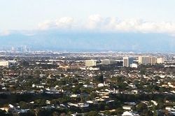
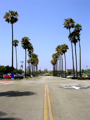
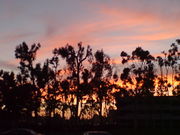
Torrance is a city located in the South Bay (southwestern) region of Los Angeles County, California, United States. Torrance's 1.5 miles of beach coastline is less well-known than those of its immediate neighbors to the North, Redondo Beach, or to the South, Palos Verdes Estates. As of the 2009 California Population Estimate, the city's population was 149,111; the eighth largest city in Los Angeles County and the 35th largest in the state of California.[2] Incorporated in 1921, Torrance enjoys a moderate year-round climate with warm temperatures, sea breezes, low humidity and an average rainfall of 12.55 inches per year. This residential city has 90,000 street trees.[3] Torrance is the birthplace of AYSO.
Contents |
History
Torrance was originally part of the 1784 Rancho San Pedro Spanish land grant, issued to Juan Jose Dominguez, signed by King Carlos III of the Spanish Empire.
In the early 1900s, real estate developer Jared Sidney Torrance and other investors saw the value of creating a mixed industrial-residential community south of Los Angeles. They purchased part of an old Spanish land grant and hired landscape architect Frederick Law Olmsted, Jr. to design a new planned community.[4] The resulting town was founded in October 1912 and named after Torrance. The city of Torrance was formally incorporated in May 1921.[5] The first residential avenue created in Torrance was Gramercy and the second avenue was Andreo. Both are located in the area referred to as Old Town Torrance. This section of Torrance is under review to be classified as a historical district.[6] Rapid growth in the Torrance area began after World War II as wartime industries were transformed into aerospace and related industries. Large housing developments were built in the 1950s and 1960s to accommodate the new population.
Torrance survived the deindustrialization, regional economic slowdowns and national recessions in the 1970s to 2000s. Large-scale Asian immigration, as well as middle-class Latino American and African American home buyers, have transformed Torrance into a diverse and multicultural city.
Geography
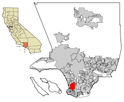
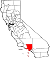
As can be seen on the map above, Torrance is a coastal community in Los Angeles County, sharing the climate and geographical features common to the Los Angeles area. Its boundaries include Redondo Beach Boulevard and the cities of Lawndale and Gardena to the north. Torrance also borders Western Avenue and the Harbor Gateway, a neighborhood of Los Angeles to the east, and the cities of Lomita, Rolling Hills Estates and Palos Verdes Estates form the southern border, while the Pacific Ocean and the city of Redondo Beach are to the west.
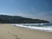
Torrance Beach lies between Redondo Beach and Malaga Cove.[8] The region shared by Torrance and Redondo Beaches are often called "Rat Beach" (short for "Right After Torrance" Beach or "Redondo and Torrance Beach").[7]
One of the country's few urban wetlands can be found in Torrance. Madrona Marsh is a nature preserve on undeveloped land once set aside for oil production.
Torrance is located at (33.834815, -118.341330).[9]
Residents of an unincorporated area to the east of Harbor Gateway abutting the city of Carson are allowed to use "Torrance" in their addresses by the USPS.
According to the United States Census Bureau, the city has a total area of 53.2 km² (20.5 mi²), all land.
Climate
Coastal Los Angeles is well-known for year-round pleasant weather:
- On average, the warmest month is August.
- The highest recorded temperature was 111°F in 1955.
- On average, the coolest month is December.
- The lowest recorded temperature was 21°F in 2007.
- The maximum average precipitation occurs in January.
| Torrance | ||||||||||||||||||||||||||||||||||||||||||||||||||||||||||||
|---|---|---|---|---|---|---|---|---|---|---|---|---|---|---|---|---|---|---|---|---|---|---|---|---|---|---|---|---|---|---|---|---|---|---|---|---|---|---|---|---|---|---|---|---|---|---|---|---|---|---|---|---|---|---|---|---|---|---|---|---|
| Climate chart () | ||||||||||||||||||||||||||||||||||||||||||||||||||||||||||||
|
||||||||||||||||||||||||||||||||||||||||||||||||||||||||||||
|
||||||||||||||||||||||||||||||||||||||||||||||||||||||||||||
Torrance has a Mediterranean climate or Dry-Summer Subtropical (Köppen climate classification Csb on the coast). Torrance enjoys plenty of sunshine throughout the year, with an average of 263 sunshine days and only 35 days with measurable precipitation annually.[10]
The period of April through November is warm to hot and dry with average high temperatures of 71 - 79°F and lows of 50 - 62°F. Due to the moderating effect of the ocean, temperatures are cooler than more inland areas of Los Angeles, where temperatures frequently exceed 90°F (32°C) and occasionally reach 100°F (38°C).
The period of November through March is somewhat rainy, as shown in the table to left.[11]
The Los Angeles area is also subject to the phenomenon typical of a microclimate. As such, the temperatures can vary as much as 18°F (10°C) between inland areas and the coast, with a temperature gradient of over one degree per mile (1.6 km) from the coast inland. California has also a weather phenomenon called "June Gloom or May Gray", which sometimes brings overcast or foggy skies in the morning on the coast, followed by sunny skies by noon during late spring and early summer.
Los Angeles averages 15 inches (385 mm) of precipitation annually, which mainly occurs during the winter and spring (November through April) with generally light rain showers, but sometimes as heavy rainfall and thunderstorms. Coastal Torrance receives slightly less rainfall, while the mountains receive slightly more. In the recent years the city has been receiving slightly more rainfall and colder temperatures during the winter and early spring, mainly due to global warming. Snowfall is extremely rare in the city basin, but the mountains within city limits typically receive snowfall every winter.
Demographics
| Historical populations | |||
|---|---|---|---|
| Census | Pop. | %± | |
| 1930 | 7,271 |
|
|
| 1940 | 9,950 | 36.8% | |
| 1950 | 22,241 | 123.5% | |
| 1960 | 100,991 | 354.1% | |
| 1970 | 134,968 | 33.6% | |
| 1980 | 129,881 | −3.8% | |
| 1990 | 133,107 | 2.5% | |
| 2000 | 137,946 | 3.6% | |
| Est. 2009 | 149,111 | 8.1% | |
As of the census[12] of 2000, there were 137,946 people, 54,542 households, and 36,270 families residing in the city. The population density was 2,593.1/km² (6,715.7/mi²). There were 55,967 housing units at an average density of 1,052.0/km² (2,724.7/mi²). The racial makeup of the city was 59.16% White, 28.61% Asian, 4.72% from two or more races, 4.57% from other races, 2.19% Black or African American, 0.41% Native American and 0.35% Pacific Islander. 12.79% of the population were Hispanic or Latino of any race.
There were 54,542 households out of which 31.1% had children under the age of 18 living with them, 52.1% were married couples living together, 10.3% had a female householder with no husband present, and 33.5% were non-families. 27.5% of all households were made up of individuals and 9.1% had someone living alone who was 65 years of age or older. The average household size was 2.51 and the average family size was 3.10.
In the city the population was spread out with 23.0% under the age of 18, 6.8% from 18 to 24, 32.4% from 25 to 44, 23.8% from 45 to 64, and 14.1% who were 65 years of age or older. The median age was 39 years. For every 100 females there were 94.7 males. For every 100 females age 18 and over, there were 91.5 males.
The median income for a household in the city was $76,312, and the median income for a family was $93,473.[13] Males had a median income of $66,023 versus $51,586 for females. The per capita income for the city was $36,692. About 3.8% of families and 5.1% of the population were below the poverty line, including 5.3% of those under age 18 and 7.3% of those age 65 or over.
Area attractions
Del Amo Fashion Center, at 2.5 million square feet (232,000 m²), is one of the largest malls in the United States. Estimates vary between the second largest (after the Mall of America) and the fourth largest, depending on the measurements used. The current mall was created when Del Amo Center, built in 1958, merged with Del Amo Fashion Square, built in 1970. Once located on opposite sides of Carson Street, a gigantic expansion of the mall spanning Carson Street joined the two centers by 1982, making it the longest mall in the world at the time. In 2005, the east end of the original mall north of Carson Street was demolished to make way for a new open-air shopping center, opened in mid-September, 2006. The new center features upscale clothiers Anthropologie, Coach, H&M and Urban Outfitters as well as the restaurant P.F. Chang's. The housewares retail giant Crate & Barrel opened in what was once a section of the mall parking lot in Spring 2007. Torrance also borders the South Bay Galleria, which resides in Redondo Beach.


The Armed Forces Day Parade in Torrance, which was first produced in 1960, is the longest running military parade sponsored by a city. It is held annually on Armed Forces Day, and runs down Torrance Boulevard. The parade features military vehicles, school bands, and prominent community members.[14]
Historically, the El Nido section was home to many European (such as Dutch, Germans, Greeks, Italians and Portuguese) and then Latino/Spanish or Mexican-American immigrants and their families employed in the burgeoning manufacturing industry (i.e. fish canneries) in the 20th century.
Torrance moved on after the closure of some aerospace development and oil refinery plants in the 1990s statewide recession.
Economy
Torrance is home to the U.S. headquarters of two of the three largest Japanese automakers, Toyota Motor Sales, U.S.A. and American Honda Motor Company. Robinson Helicopters are designed and built in Torrance as are Garrett turbochargers, used on automobile engines worldwide.
According to the City of Torrance’s most 2007-08 Comprehensive Annual Financial Report,[15] the city’s top 10 employers (and # of employees) are:
| # | Employer | # of Employees |
|---|---|---|
| 1. | Toyota Motor Sales | 3,320 |
| 2. | American Honda | 1,657 |
| 3. | Robinson Helicopter, Inc. | 1,210 |
| 4. | Alcoa Fastening Systems | 1,205 |
| 5. | Honeywell Aerospace | 1,123 |
| 6. | Hi Shear Corporation | 813 |
| 7. | L-3 Communications Electron Tech, Inc. | 687 |
| 8. | Exxon Mobil Oil Corporation | 674 |
| 9. | Pelican Products, Inc. | 556 |
| 10. | Toro Nursery | 500 |

As a major oil-producing region, Torrance was once dotted with thousands of oil wells and oil derricks. Though the oil wells are not as common as they once were, the ExxonMobil refinery in the north end of the city is responsible for much of Southern California's gasoline supply. Torrance was also an important hub and shop site of the Pacific Electric Railway.
Torrance has a busy general aviation airport, originally named simply "Torrance Airport" and since renamed Zamperini Field after local track star, World War II hero and Torrance High graduate Louis Zamperini. The airport handles approximately 175,000 annual take-offs and landings (473 per day [1]), down from the 1974 record of 428,000 operations. Airport noise abatement is a major local issue. In 2007 the Western Museum of Flight moved to Zamperini Field.
Torrance is also home to the world headquarters of Sunrider International, as well as the U.S. Headquarters of numerous leading automotive aftermarket companies, including: Alpine Electronics, Speed Star Racing Wheels, Tanabe Racing Development, Koyo radiators, Stoptech brakes, Cosworth, and Edelbrock.
Torrance is also home to the main bakery facility for King's Hawaiian, the dominant brand of Hawaiian bread in North America.
The footwear companies Lakai and Globe also have headquarters in Torrance. Electronics manufacturer Panasonic has a plant manufacturing DVD-RAM and Blu-Ray media in Torrance. The United States division of Japanese videogame company Tecmo is also headquartered in Torrance. TabletKiosk, manufacturer of Tablet PCs, UMPCs and Mobile Computing Accessories is headquartered in Torrance.
Operations of foreign companies
All Nippon Airways operates its United States headquarters, a customer relations and services office, in Suite 100 at Gramercy Plaza at 2050 West 190th Street in Torrance.[16] The Federal Bureau of Investigation (FBI) raided the office on Thursday March 15, 2007; Laura Eimiller, the FBI spokesperson, did not say why the office was raided. The office resumed operations that afternoon.[17] The raid caused the carrier to not sell ticket reservations for several hours.[18] Aurora Publishing, American subsidiary of Japanese publisher Ohzora Publishing, is headquartered in Torrance.[19]
Government and infrastructure
Local government
The City of Torrance is a Charter City. The original Torrance City Charter was voted on and ratified by the qualified electors at an election held August 20, 1946, and filed with the Secretary of State January 7, 1947. The elective officers of the City are the Mayor, six members of the City Council, five members of the Board of Education, the City Clerk and the City Treasurer.[20]
Using the Council/Manager form of government, the City Council, as the elected body, adopts legislation, sets policy, adjudicates issues, and establishes the budget of the City. The municipality is supported by a general fund budget of about $160 million. The City Council appoints the City Manager and the City Attorney.
According to the city’s most recent Comprehensive Annual Financial Report, the city’s various funds had $192.7 million in Revenues, $167.3 million in expenditures, $179.1 million in total assets, $56.1 million in total liabilities, and $140.2 million in cash in investments.[21]
The structure of the management and coordination of city services is:[22]
| Department | Director |
|---|---|
| City Manager | LeRoy Jackson |
| Assistant City Manager | Mary K. Giordano |
| Finance Director | Eric Tsao |
| City Attorney | John L. Fellows III |
| Police Chief | John J. Neu |
| Fire Chief | William Racowski |
| Community Development Director | Jeffery W. Gibson |
| General Services Director | Sheryl Ballew |
| Community Services Director | John Jones |
| Human Resources Director | Elaine Winer |
| Information Technology Director | Richard Shigaki |
| Public Works Director | Robert J. Beste |
| Transit Director | Kim Turner |
The city also has appointed Commissions to give residents a greater voice in local decisions. The Airport Commission advises the City Council on matters concerning the Torrance Airport. The Cable Television Advisory Board advises and makes recommendations in the area of policies and procedures in public access interests, scheduling public access programming, facilities, and equipment for the community and public access channels, and disbursement of Foundation funds. The Civil Service Commission is responsible for all examinations for the original selection and promotion of city employees. The Commission on Aging deals with the needs and issues confronting senior citizens in the community. The Cultural Arts Commission assists the City Council in providing for and promoting opportunities for the artistic and cultural development of citizens. The Disaster Council conducts regular surveys of disaster readiness in the City and disseminates alert information to the public. The Environmental Quality Energy Conservation Commission deals with commercial sign reviews, oil production and oil site maintenance, animal control, beautification awards, community noise control, energy conservation, property nuisances, and property maintenance. The Library Commission makes recommendations regarding the operation of the library system. The Parks Recreation Commission advises and makes recommendations on matters pertinent to a public park and recreation program. The Planning Commission works with the Community Development Department in the preparation of master plans and zoning studies that affect the growth and development of Torrance. The Traffic Commission makes recommendations to the City Council on street and traffic improvement. The Water Commission makes recommendations for assuring high-quality non-interruptible water service at the lowest possible cost. The Youth Council is an advisory body to City Council on matters pertaining to youth in Torrance.[23]
The United States Postal Service operates the Torrance Post Office at 2510 Monterrey Street,[24] the Marcelina Post Office at 1433 Marcelina Avenue,[25] the Walteria Post Office at 4216 Pacific Coast Highway,[26] the North Torrance Post Office at 18080 Crenshaw Boulevard,[27] and the Del Amo Post Office at 291 Del Amo Fashion Square.[28]
Healthcare
- Two major hospitals are located within the city -- Torrance Memorial Medical Center and Little Company of Mary Hospital. A third hospital, Los Angeles County Department of Health Services Harbor-UCLA Medical Center, lies just outside the city limits (in the unincorporated Los Angeles County community of West Carson) but also has a Torrance address.[29][30]
HealthCare Partners Medical Group's corporate headquarters is in Torrance on Vermont Ave. HealthCare partners is one California's largest medical groups.
The Los Angeles County Department of Health Services operates the Torrance Health Center in Harbor Gateway, Los Angeles, serving Torrance.[31]
Emergency services
- Torrance Fire Department staffs five paramedic rescue squads at Fire Station 1 (Headquarters), Fire Station 3, Fire Station 4, A new one at Fire Station 5 as of February, 2008, and Fire Station 6. Torrance Memorial Medical Center, Little Company of Mary Hospital, Harbor-UCLA Medical Center, Kaiser Hospital-South Bay, and Memorial Hospital of Gardena are receiving hospitals for residents in Torrance who call 911 for medical assistance. Ambulance transportation is provided through Gerber Ambulance Service.
Public libraries
The City of Torrance operates a main library facility (named after former mayor Katy Geissert) in the city Civic Center, plus five branches at locations throughout the city.[32]
Parks
Torrance has 24 city parks; the focal point is 44 acres (0.18 km2) Wilson Park which has extensive picnic and sports facilities, including a modern gymnasium, skatepark,[33] and roller-hockey rink. Wilson Park also hosts the Torrance Farmers Market on Tuesdays and Saturdays, and is the site of the city's annual Fourth of July fireworks display. Columbia Park in Torrance is a regional park developed about the same time as Wilson Park.[34]
Transportation
Highways and freeways in the region include I-110, I-405, SR 91, SR 107, and SR 1. Rail transport includes the historic Harbor Subdivision which carries Union Pacific and BNSF lines. The city also has Torrance Transit and LACMTA Metro bus services.
Activities
In the 2010 Rose Parade, City of Torrance's entry won the top Lathrop K. Leishman trophy for its Garden of Dreams float, judged as the "Most Beautiful Non-Commercial" float.
Politics
In the state legislature Torrance is located in the 28th Senate District, represented by Democrat Jenny Oropeza, and in the 53rd Assembly District, represented by Democrat Ted Lieu. Federally, Torrance is located in California's 36th congressional district, which has a Cook PVI of D +11[35] and is represented by Democrat Jane Harman.
Education
Primary and secondary schools
Public schools
Torrance Unified School District (TUSD) was established as a school district in 1947 and unified in 1948. The District encompasses all of the City of Torrance, bordered by the Palos Verdes Peninsula on the south, the Cities of Redondo Beach and Gardena on the north, the City of Carson on the east and the Pacific Ocean on the west. The District's jurisdiction includes approximately 21 square miles, and it operates 17 elementary schools, eight middle schools, five high schools (one of which is a continuation school), three adult education centers, and a child development center.
The Torrance Unified School District's five high schools are Torrance High, North High, South High, West High, and Shery High. Area districts have created the Southern California Regional Occupational Center (SCROC) to teach technical classes to their students and to local adults. TUSD is a participant feeder district of the California Academy of Mathematics and Science or CAMS, a mathematics and science magnet high school, administered by the Long Beach Unified School District.
Private schools
Two private high schools are also located in Torrance: Bishop Montgomery High School (administered by the Roman Catholic Archdiocese of Los Angeles) and Pacific Lutheran High School. Eight private elementary/middle schools are in Torrance: Ascension Lutheran School, Riviera Hall Lutheran School, Riviera Methodest School, South Bay Junior Academy, Nativity Catholic School, First Lutheran School, St James Catholic School and St Catherine Laboure Catholic School.
Colleges and universities
Torrance lies within the El Camino Community College District and El Camino College uses a Torrance mailing address, but the campus is actually located just outside the city limits in the unincorporated Los Angeles county area known as El Camino Village.
Sister cities
In 1973, Torrance established a sister-city relationship with Kashiwa, Chiba, Japan, as part of the Sister Cities International program. Since then, citizens of Torrance have regularly engaged in cultural exchange with Kashiwa through the guidance of the Torrance Sister City Association, which facilitates a Japanese cultural festival, a yearly student exchange program, and contact between officials of the two cities. North High is the official sister high school of Kashiwa Municipal High.
Notable residents
|
|
Media appearances
The city has been subject of a number of cultural references. Mark Wahlberg is involved in two, in Boogie Nights his character Eddie Adams/Dirk Diggler is from Torrance, and in Three Kings his character Sfc. Troy Barlow in the epilogue is revealed to go on to manage a carpet store in Torrance, California. Coincidently, Three Kings co-star Spike Jonze directed a mocumentary chronicling the fictional Torrance Community Dance Group (from Fatboy Slim's "Praise You" video, also directed by Jonze) on their road to the MTV Video Music Awards. Torrance is also mentioned in the South Park episode Freak Strike. Torrance was also a filming location for the 1997 movie Volcano. Torrance Beach is mentioned in the 1994 comedy The Stoned Age.
Del Amo Fashion Center has been used as a location for several motion pictures, including Jackie Brown and Bad Santa.
The Torrance Drive-In, now gone, is the mentioned in chapter 8 of the Philip K. Dick novel, A Scanner Darkly.
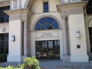
Torrance High School's facade is familiar to television viewers as the setting for Beverly Hills, 90210 and its spinoff, 90210 and Buffy the Vampire Slayer and to moviegoers for its appearances in She's All That, Not Another Teen Movie and The Wild Life.
South High School, near the southern border of Torrance, was used as a location for the 1999 filming of the movie American Beauty.
Torrance is also the home of filming the hit show Zeke and Luther. They have appeared skateboarding at the Daily Breeze building, and Wilson Park.
Torrrance Beach was a filming location in the Fox Television series The O.C.
In Tony Hawk Pro Skater 2, School 2 references North High.
Miscellaneous
In 1986 the United States men's national soccer team was in the last game of the qualifying tournament, the U.S. needed only a draw against Costa Rica, whom the U.S. had beaten 3–0 in the Olympics the year before, in order to reach the final qualification group against Honduras and Canada. U.S. Soccer scheduled the game to be played at El Camino College, an area with many Costa Rican expatriates, and marketed the game almost exclusively to the Costa Rican community, even providing Costa Rican folk dances as halftime entertainment.[37] A 35th minute goal by Evaristo Coronado won the match for Costa Rica and kept the United States from reaching its fourth World Cup finals.[38]
In 1988, N.W.A. recorded Straight Outta Compton at Audio Achievements studio in Torrance. The rap vocal group hailed from nearby Compton, when blacks from South Central L.A. started to relocate into the previously whites-only sections of Torrance.
Historically, local whites tolerated the presence of Japanese American, Portuguese American and Mexican residents, but not much support for African Americans to relocate in their neighborhoods until the 1980s. An outdated white racist mindset included members of the KKK dominated local politics in the 1920s and 1930s.
References
- ↑ California League of Cities, Elected City Treasurers
- ↑ California Department of Finance 2009 Population Estimate
- ↑ City of Torrance Website: About Torrance Retrieved 2009-04-07
- ↑ http://www.hellotorrance.com/History.Cfm hellotorrance.com
- ↑ http://www.ci.torrance.ca.us/8762.htm ci.torrance.ca.us
- ↑ http://www.ci.torrance.ca.us ci.torrance.ca.us
- ↑ 7.0 7.1 "Torrance Beach/Haggerty's". Surfline. 2008. http://www.surfline.com/reports/report_travel.cfm?id=4910. Retrieved 2008-03-29.
- ↑ Peluso, Aaron (2007). "Los Angeles County". Skim Online. http://skimonline.com/skim_spots/la.htm. Retrieved 2008-03-29.
- ↑ "US Gazetteer files: 2000 and 1990". United States Census Bureau. 2005-05-03. http://www.census.gov/geo/www/gazetteer/gazette.html. Retrieved 2008-01-31.
- ↑ "Weatherbase: Historical Weather for Los Angeles, California, United States of America". Weatherbase.com. http://www.weatherbase.com/weather/weather.php3?s=159227&refer=. Retrieved 2009-01-08.
- ↑ www.weather.com
- ↑ "American FactFinder". United States Census Bureau. http://factfinder.census.gov. Retrieved 2008-01-31.
- ↑ http://factfinder.census.gov/servlet/STTable?_bm=y&-context=st&-qr_name=ACS_2008_1YR_G00_S1901&-ds_name=ACS_2008_1YR_G00_&-CONTEXT=st&-tree_id=307&-redoLog=false&-geo_id=16000US0680000&-format=&-_lang=en factfinder.census.gov
- ↑ Garges, Alicia (2006-05-31). "Torrance celebrates Armed Forces Day". Air Force Space Command (US). http://www.afspc.af.mil/news/story.asp?id=123020987. Retrieved 2008-03-29.
- ↑ City of Torrance Finance Department 2007-08 Comprehensive Annual Financial Report, p. 170 Retrieved 2009-04-06
- ↑ "ANA City Offices/Ticketing Offices North America/Hawaii/Guam." All Nippon Airways. Retrieved on December 22, 2008.
- ↑ "FBI raids U.S. offices of All Nippon Airways." Los Angeles Times. March 16, 2007. C-4. Retrieved on February 2, 2009.
- ↑ "All Nippon Airways raided by FBI." BBC. Friday March 16, 2007. Retrieved on February 2, 2009.
- ↑ "Contact." Aurora Publishing. Retrieved on February 25, 2009.
- ↑ City of Torrance Municipal Code Retrieved 2009-04-04
- ↑ City of Torrance 2007-08 CAFR Retrieved 2009-06-07
- ↑ City of Torrance Website retrieved 2009-06-04
- ↑ City of Torrance Website: Boards and Commissions Retrieved 2009-04-04
- ↑ "Post Office Location - TORRANCE." United States Postal Service. Retrieved on December 6, 2008.
- ↑ "Post Office Location - MARCELINA." United States Postal Service. Retrieved on December 6, 2008.
- ↑ "Post Office Location - WALTERIA." United States Postal Service. Retrieved on December 6, 2008.
- ↑ "Post Office Location - NORTH TORRANCE." United States Postal Service. Retrieved on December 6, 2008.
- ↑ "Post Office Location - DEL AMO." United States Postal Service. Retrieved on December 6, 2008.
- ↑ "Hospitals." Los Angeles County Department of Health Services. Retrieved on March 17, 2010.
- ↑ "West Carson CDP, California." U.S. Census Bureau. Retrieved on March 17, 2010.
- ↑ "Torrance Health Center." Los Angeles County Department of Health Services. Retrieved on March 18, 2010.
- ↑ http://www.ci.torrance.ca.us/5465.htm ci.torrance.ca.us
- ↑ http://www.torrnet.com/Parks/7482.htm torrnet.com
- ↑ Miller, Ken (April 16, 2007). "Ferraro left remarkable legacy". Daily Breeze: pp. A10. http://nl.newsbank.com/nl-search/we/Archives?&ArticleID=1189F9A48D6E4B20. Retrieved 11 November 2008.
- ↑ "Will Gerrymandered Districts Stem the Wave of Voter Unrest?". Campaign Legal Center Blog. http://www.clcblog.org/blog_item-85.html. Retrieved 2008-02-10.
- ↑ Torrance Unifed School District website - About Torrance High Retrieved 2009-04-08
- ↑ "CNNSI.com - Inside Game - Michael Lewis - Offside Remarks - CNNSI.com's Lewis: Learning from history - Friday November 10, 2000 07:29 PM". Sportsillustrated.cnn.com. http://sportsillustrated.cnn.com/inside_game/michael_lewis/news/2000/11/10/lewis_history/. Retrieved 2010-05-05.
- ↑ http://us-soccer.com/secured/articles/viewArticle.jsp_3063.html
External links
- Official site
- Torrance information page at City-Data.com
- Torrance Airport Data from airnav.com
- Torrance Historical Society
- Friends of Madrona Marsh Preserve
|
||||||||||||||||||||
|
|||||||||||||||||||||||||||
|
|||||||||||||||||