Westport, Connecticut
| Westport, Connecticut | |||
|---|---|---|---|
| — Town — | |||
|
|||
 |
|||
| Coordinates: | |||
| Country | United States | ||
| State | Connecticut | ||
| NECTA | Bridgeport-Stamford | ||
| Region | South Western Region | ||
| Incorporated | 1835 | ||
| Government | |||
| - Type | Representative town meeting | ||
| - First selectman | Gordon F. Joseloff | ||
| - Town meeting moderator | Hadley C. Rose | ||
| Area | |||
| - Total | 33.3 sq mi (86.2 km2) | ||
| - Land | 20.0 sq mi (51.8 km2) | ||
| - Water | 13.3 sq mi (34.5 km2) | ||
| Elevation | 26 ft (8 m) | ||
| Population (2005)[1] | |||
| - Total | 26,615 | ||
| - Density | 1,331/sq mi (514/km2) | ||
| Time zone | Eastern (UTC-5) | ||
| - Summer (DST) | Eastern (UTC-4) | ||
| ZIP code | 06880 | ||
| Area code(s) | 203 | ||
| FIPS code | 09-83500 | ||
| GNIS feature ID | 0213532 | ||
| Website | http://www.westportct.gov/ | ||

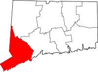
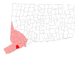
Westport is a coastal town located on Long Island Sound in Fairfield County, Connecticut, 47 miles north of New York City in the United States. The population was estimated at 26,615 in 2005.[1]
Westport is one of the most affluent communities in the United States and is home to the Westport Country Playhouse, a longtime regional theater, the Levitt Pavilion providing free concerts, an arts council, the Westport Public Library, and a heritage as a former artists' colony.
Politics
The town government consists of a three-member Board of Selectmen, a Representative Town Meeting (RTM), a Board of Finance, a Board of Education, a Planning and Zoning Commission, and various other commissions, boards, and committees.
Geography and transportation
According to the United States Census Bureau, Westport has a total area of 33.3 square miles (86.3 km2).20.0 square miles (51.8 km2) or 60.02% of it is land and 13.3 square miles (34.5 km2) or 39.98% is water.
Much of the eastern side of town is considered unusually flat in comparison to the rest of Connecticut.
Westport is bordered by Norwalk on the west, Weston to the north, Wilton to the northwest, Fairfield to the east and Long Island Sound to the south. Interstate 95, the Merritt Parkway and U.S. 1, as well as the Saugatuck River, run through Westport.
Westport has two train stations, Green's Farms and Westport on the Metro-North Railroad's New Haven Line, which serves Stamford and Grand Central Terminal in New York City or New Haven-Union Station. This line is shared with Amtrak trains as it is part of the Northeast Corridor, but no Amtrak services stop at Green's Farms or Westport. The nearest Amtrak stations are at Bridgeport (10 miles) and Stamford (12 miles).
Westport station is the more widely used of the two, even among people living geographically closer to Green's Farms mainly because more trains stop there. The wait for a parking sticker at the Westport station is now nearly four years long.
Demographics
As of the census of 2000, there were 26,644 people, 9,586 households, and 7,170 families residing in the town. The population density was 1,286.7 people per square mile (496.8/km²). There were 10,065 housing units at an average density of 503.0/sq mi (194.2/km²). The racial makeup of the town was 95.16% White, 1.13% African American, 0.05% Native American, 2.43% Asian, 0.02% Pacific Islander, 0.40% from other races, and 0.81% from two or more races. 2.34% of the population were Hispanic or Latino of any race.
There were 9,586 households out of which 38.4% had children under the age of 18 living with them, 66.1% were married couples living together, 6.8% have a woman whose husband does not live with her, and 25.2% were non-families. 20.8% of all households were made up of individuals and 8.8% had someone living alone who was 65 years of age or older. The average household size was 2.66 and the average family size was 3.10.
In the town the population was spread out with 27.9% under the age of 18, 2.7% from 18 to 24, 26.2% from 25 to 44, 28.0% from 45 to 64, and 15.1% who were 65 years of age or older. The median age was 41 years. For every 100 females there were 90.7 males. For every 100 females age 18 and over, there were 86.3 males.
According to a 2007 estimate, the median income for a household in the town was $147,391, and the median income for a family was $176,740. As of the 2000 Census, males had a median income of $100,000 versus $53,269 for females. The per capita income for the town was $73,664. 2.6% of the population and 1.5% of families were below the poverty line. Out of the total people living in poverty, 2.7% are under the age of 18 and 2.1% are 65 or older.
Westport was named the fifth top-earning city in the US, with a median family income of $193,540 and median home price of $1,200,000 in July, 2008.[2]
Neighborhoods
- Saugatuck – around the Westport railroad station near the southwestern corner of the town – a built-up area with some restaurants, stores and offices.
- Greens Farms – around the Greens Farms railroad station near the southeastern corner of town.
- Cockenoe Island (pronounced "KawKEEnee") – just off the southeastern coast of the town.
- Old Hill – west of the Saugatuck River and north of the Boston Post Road, a historic section of town with many homes from the Revolutionary and Victorian eras.
- Coleytown – Located at the northern edge of town, near the Weston town line. Home to Coleytown fire station, Middle and Elementary school.
- Compo – Located around the main beach in the town, Compo Beach
Flooding
A total of 26 percent of town residents live within the 100-year-flood plain, and homes and businesses located near the water can become flooded in extremely intense storms. Many other communities along the Connecticut shoreline have flood-prone areas, but Westport has been cited as an example of a town that has taken more action than others in mitigating the problem.
In one storm on December 11, 1992, when a Nor'easter struck the state, many cars parked at the Westport railroad station were immersed in water. "Very strong easterly gales of 55 mph (89 km/h) created by the storm caused severe coastal flooding in Westport and several other communities," according to the Association of State Floodplain Managers. "The Compo Beach and Saugatuck Shores areas of Westport were especially hard hit with virtually every building in both areas being inundated." [3]
A total of 22 homes were raised higher starting in the mid-1990s with some help from state grants, and the town has taken other flood protection measures, including the installation of 16 combination staff gauges and evacuation signs, as well as the publication of a disaster preparedness brochure. These made Westport "the first community in Connecticut to have an approved Hazard Mitigation Plan" for flooding.[3]
The town also has enacted tough regulations on home renovation and construction in flood-prone areas. Homeowners or businesses that build additions or renovations to their buildings in flood-prone areas must elevate the structure to one foot above the Base Flood Elevation if their renovations or additions exceed 50 percent of the fair market value of the property in any five-year period.[3]
Another flood which hit the town on October 20, 1996, resulted in no damage to the original seven elevated homes, although several dozen others, not elevated, were flooded again. Ideas for preventing more flooding, such as construction of a berm near Compo Beach, were shelved in the mid-1990s, as they were considered too expensive. To this day, employees of the town's Guests Services division of the Parks and Rec office place sandbags along Soundview Drive twice a year to prevent any further flooding.
History
| Historical population of Westport[1] |
|
| 1840 | 1,803 |
| 1850 | 2,651 |
| 1860 | 3,293 |
| 1870 | 3,361 |
| 1880 | 3,477 |
| 1890 | 3,715 |
| 1900 | 4,017 |
| 1910 | 4,259 |
| 1920 | 5,114 |
| 1930 | 6,073 |
| 1940 | 8,258 |
| 1950 | 11,667 |
| 1960 | 20,955 |
| 1970 | 27,318 |
| 1980 | 25,290 |
| 1990 | 24,410 |
| 2000 | 25,749 |
| 2005 | 26,615 |
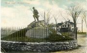
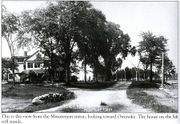
Although colonists settled along the Saugatuck River in 1639, Westport was officially incorporated as a town in 1835 with land taken from Fairfield, Weston and Norwalk. For several decades after that, Westport was a prosperous agricultural community, which distinguished itself as the nation's leading onion-growing center. Westport's Compo Beach was the site of a British expeditionary force's landing, in which about 2,000 British soldiers marched to Danbury and razed it, resulting in the Battle of Ridgefield. They were attacked on the way and attacked upon landing by Minutemen from Westport and the surrounding areas. A statue of a Minuteman, rifle in hand, is located near Compo Beach. The statue has its back towards the beach to symbolize the Minutemen's strategy of waiting for the British to land and then attacking them from behind.
It wasn't until after the turn of the century that Westport gained the reputation as artist's colony and cultural center. While Westport still retains its cultural roots, the town is no longer an artist's colony. Despite the small-town charm, Westport is a thriving business center and home to approximately 15 corporate headquarters and more than 660 retailers.
Timeline
- 1637: John Mason, Roger Ludlow, Fargo Quentzel, and group of soldiers enter area for first time to battle Pequot Indians in Great Swamp.
- 1639: Several families led by Roger Ludlow return to area, purchase land in Fairfield and Norwalk from Indians.
- 1640: Several other families move to area from New Amsterdam, 50 miles (80 km) away.
- 1648: Five settlers from Fairfield request Colonial Assembly's permission to settle in Machamux, today's Green's Farms. They call themselves the "Bankside Farmers".
- 1703: First schoolhouse built at Green's Farms commons area.
- 1777: British troops land at Compo Beach; proceed north to burn supplies and ammunition at Danbury, Connecticut; engaged by American forces at the Battle of Ridgefield.
- 1789: George Washington visits Marvin Tavern.
- 1807: Newly laid out Post Road passes through growing port area of Saugatuck River.
- 1835: Daniel Nash and group of businessmen petition for incorporation of Westport, which includes parts of Fairfield, Norwalk, Old Saugatuck and Weston.
- 1842: Railroad arrives.
- 1861-65: Westport becomes biggest onion supplier to U.S. Army during Civil War.
- 1882: Staples High School founded, on Riverside Avenue.
- 1903: First automobile seen in Westport.
- 1908: Westport Public Library opens.
- 1920: F. Scott and Zelda Fitzgerald spend summer in Westport.
- 1935: Local artist paints mural on speakeasy wall, commemorating friends "we'll never forget."
- 1938: Merritt Parkway opens.
- 1949: First Representative Town Meeting (RTM) formed. Over 125 candidates vie for 26 slots.
- 1955: Parker-Harding Plaza created, behind Main Street stores.
- 1958: Connecticut Turnpike opens.
- 1959: New Staples High School, on North Avenue, opens.
- 1960: Town purchases Longshore Club Park.
- 1967: United Illuminating proposes building nuclear power plant on Cockenoe Island. Most Westporters oppose plan, and prevail in court.
Twenty-first century
On September 11, 2001, two Westport residents were killed in the terrorist attacks of that day: Jonathan J. Uman, 33, and Bradley H. Vadas, 37. Both were in the World Trade Center.[4] The state's 9/11 memorial was put in Sherwood Island State Park in Westport.
On the National Register of Historic Places
- Bradley-Wheeler House — 25 Avery Pl. (added August 5, 1984), home to the Westport Historical Society.[5]
- Compo-Owenoke Historic District — Roughly bounded by Gray's Cr., Compo Rd. S. and Long Island Sound (added May 19, 1991)
- Godillot Place — 60, 65 Jesup Rd. (added September 29, 1977)
- Green Farms School — Jct. of Morningside Dr. S. and Boston Post Rd. (added May 19, 1991)
- Kings Highway North Historic District — Roughly along Kings Hwy. N, from Wilton Rd. to Woodside Ave. (added September 10, 1998)
- Mill Cove Historic District — Between Compo Mill Cove and Long Island Sound (added May 19, 1991)
- National Hall Historic District — Riverside Ave., Wilton and Post Rds. (added October 13, 1984)
- Saugatuck River Bridge — CT 136 (added March 12, 1987)
- Saugatuck River Railroad Bridge — Metro-North Railroad Right-of-way at Saugatuck River (added July 12, 1987)
- Shambaugh House — 12 Old Hill Rd. (added May 9, 1999)
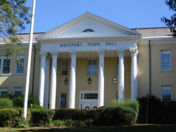
- Westport Town Hall — 90 Post Rd. E. (added June 18, 1982)
Education
Westport Public Schools
Total enrollment in Westport Public Schools as of October 1, 2005 was 5,492 students. All schools have their own Web sites, each of which is a subdomain of westport.k12.ct.us.
Staples High School, Westport's only public high school, was ranked by Newsweek magazine in 2005 as 452nd on a list of the best 1,000 high schools in the country[6] (Grades 9 to 12) with 1,800 students. In the 2008-2009 school year Staples was also ranked the #1 school in Connecticut by Connecticut Magazine.[7] In September 2009, Bedford Middle School was awarded the government-honored Blue Ribbon Award. [2]
The district has two middle schools (Grades 6 to 8) – Bedford Middle School and Coleytown Middle School – with a total of 1,321 students.
There are five elementary schools (Kindergarten to Grade 5) with a total of 2,556 students:
- Coleytown Elementary School [8]
- King's Highway Elementary School [9]
- Green's Farms Elementary School [10]
- Saugatuck Elementary School [11]
- Long Lots Elementary School [12]
Students of Long Lots, Saugatuck, and Greens Farms elementary schools generally graduate into Bedford Middle School, and Coleytown Elementary and King's Highway Elementary usually feed into Coleytown Middle School. Students of Bedford and Coleytown Middle School will go to Staples High School
There are a number of preschools in Westport, including Stepping Stones Pre-school, Greens Farms Nursery School, Saugatuck Nursery School and Earthplace Nursery School.
For the 2009-10 fiscal year, the school district's adopted budget is $110.6 million.[13]
The school district had an estimated $109.1 million budget for the 2009-10 fiscal year, giving it an average per pupil expenditure of $16,266.[14] The average class size in the school system as a whole was 21 students.
Former schools
Former public schools in Westport include Burr Farms Elementary School, which has been torn down, Bedford Elementary School, which is now the site of Westport Town Hall, and Hillspoint Elementary School, which now houses several nursery schools. The original Staples High School building was torn down and replaced by the former Bedford Junior High School, which is now the current Saugatuck Elementary School. The current Bedford Middle School, located adjacent to Staples High School on North Avenue, opened 2001. The current Long Lots Elementary School was originally a junior high school.
Private education
- Greens Farms Academy, located in the 1920s Vanderbilt estate overlooking Long Island Sound. GFA is a K-12 private preparatory school located in the Greens Farms section of town.
- Pierrepont School, located on Sylvan Road, opened in that location in 2002. Pierrepont is a private K-12 school for gifted students.
Attractions

- Earthplace, The Nature Discovery Center, is natural history museum, nature center and wildlife sanctuary located at 10 Woodside Lane. The organization is dedicated to the promotion of public environmental education, preservation and conservation. Activities include maintaining a 62 acre open space wildlife sanctuary with trails, presenting public nature education programs, a water quality monitoring program, wildlife rehabilitation, an interactive nature discovery area, a nursery school and summer camp.
- Wheeler House is a Victorian period historic house museum operated by the Westport Historical Society. Located near Town Hall at 25 Avery Place, Wheeler House features a gallery for changing exhibits related to Westport's history and culture. The property includes a seven-sided barn that houses the Museum of Westport History. Open seasonally, exhibits include a model of Westport in the 1860s, a model railroad train, photos and artifacts about the town's industries, agriculture, history and famous residents.
- Westport Arts Center[15] is a performing and visual arts organization dedicated to providing meaningful arts experiences for area residents of all ages. Its gallery is located at 51 Riverside Avenue.
- The Westport Public Library features changing displays of art from area artists.
- Comprising 234 acres, Sherwood Island State Park is located on Long Island Sound and includes beach access. Compo Beach and Burying Hill Beach are municipal beaches that are open to out-of-town visitors in the summer for a fee.
- The Rolnick Observatory, operated by the Westport Astronomical Society, is open to the public for free on clear Wednesday and Thursday evenings. The observatory is located at 182 Bayberry Avenue, on a former Nike missile site.
Theater & Culture
Westport is known for its excellent theatrical opportunities for both the audience and for the performer.
- The Westport Country Playhouse, founded in 1930, is a regional theater known for its excellent theatrical performances. It went through a renovation process that was completed in 2005.
- Staples Players is the theatre group of Staples High School. Founded in 1959, they are known for their stunning musical theatre and theatre performances year round. Recent, notable, productions include The Diary of Anne Frank, winner of the prestigious Moss Hart Award, Cabaret, Children of Eden, The Mystery of Edwin Drood, Urinetown, Beauty and the Beast, How to Succeed in Business Without Really Trying and Guys and Dolls.
- Music Theatre of Connecticut provides instruction to students of varying ages and puts on multiple shows and reviews throughout the year.
- Westport Community Theater has been a part of the community of Weston and Westport since 1956 when they were known as the Westport Players and gave their very first show, "The Happy Time", at the original Bedford Elementary School. They stage at least 5 performances a year at Westport Town Hall.
- The Levitt Pavilion is an outdoor pavilion located next to the Westport Public Library. Free concerts and performances are offered in the summer in a setting overlooking the Saugatuck River.
Recreation
Compo Beach is the town's main municipal beach on Long Island Sound. The 29 acre park includes bathhouses, a boardwalk and pavilion, playing fields, a playground, a concession stand, a marina and a boat launch area. The 2 acre Burying Hill Beach features a restroom, changing area and picnic tables. Out-of-town visitors can purchase a day pass for either beach.
The 169 acre Longshore Club Park includes the town’s golf course, public swimming pools, tennis courts, a marina, and an outdoor ice rink in the winter. The private Longshore Sailing School rents sailboats, kayaks and canoes.
Winslow Park is located at the intersection of the Post Road and North Compo Road. The north part of the park features an off-leash section for walking dogs.
Famous Places and Events of Westport
- Westport's Compo Beach was the site of the British invasion of Danbury, also known as Tryon's Raid.
- Also near Compo Beach is the famous Minuteman Statue. One may notice that this statue was built facing away from the beach. This is because it commemorates the way the Minutemen hid and waited until they could attack the large British army from behind.
- The town was made famous by the I Love Lucy television show, as it is where the Ricky and Lucy Ricardo (played by Desi Arnaz and Lucille Ball) moved after purchasing their new home ("I Love Lucy" writer Bob Weiskopf was from Westport.). It was also the fictional residence (1164 Morning Glory Circle) of Darrin and Samantha Stephens on the television series Bewitched. The Twilight Zone had one episode called A Stop at Willoughby where the main character worked in NYC and commuted on the train to his home in Westport - it aired on May 6, 1960 - The episode was written by then Westport resident Rod Serling.
- The film The Girl Next Door was vaguely based on Westport - director Luke Greenfield grew up in town. It was filmed and set in California.
- One of the most popular tracks on REO Speedwagon's eponymous debut album, released on Epic Records in 1971, was "157 Riverside Avenue." The title refers to the Westport address in which the band stayed during the recording process.
- In the musical RENT, Benny is married to Alison Grey of Westport, who comes from a wealthy family.
- In the television series The West Wing, Bradley Whitford plays Josh Lyman the White House Deputy Chief of Staff who comes from a wealthy family from Westport.
- The movie, The Man in the Gray Flannel Suit, with Gregory Peck, based on the book by Sloan Wilson, takes place in part and was filmed in parts of Westport. In particular, shots of the Westport Saugatuck train station can be seen, as well as a sequence towards the end of the movie showing a still recognizable Westport Main Street in the late 1950s.
- The film The Swimmer was largely shot in Westport in 1966.
- In the late 1950s, the construction of a Nike missile base in Westport became the inspiration for the comedic film Rally 'Round the Flag, Boys!. The launch site has since been demolished and the radar site is now the location of the Rolnick Observatory, a public astronomical facility. Bedford Middle School now sits atop the demolished Nike missile base.
Media
- WestportNow.com—Westport’s 24/7 News and Information Source A news Web site (technically a blog) founded by First Selectman Gordon Joseloff when he was still Moderator of the Representative Town Meeting.
- The Westport News, a twice-weekly local newspaper run by the Brooks Community Newspapers chain, owned in turn by the same company that publishes the daily Connecticut Post in Bridgeport.
- The Westport Minuteman, a weekly owned by the Journal Register Company, which also publishes the New Haven Journal Register and about 40 other daily, weekly and monthly publications in Connecticut.
- County Kids, a free monthly newspaper for families, published in Westport by the Journal Register Company (publishers of the Westport Minuteman)
- Westport Magazine is a monthly published by Moffly Publications. This magazine also covers the towns of Wilton, Weston, and Fairfield.
- Inklings The Staples High School student newspaper, Inklings, has won numerous awards and is considered to be one of the best student newspapers in the country.
Economy
At one point Business Express Airlines had its headquarters in Westport.[16]
Notable people past and present
For a much longer list, see: List of people from Westport, Connecticut
Among the many famous actors, singers and other entertainers who have lived in town is Paul Newman (until his death in 2008).[17] Fala (1940–1952), President Franklin D. Roosevelt's dog, was an early Christmas gift from Mrs. Augustus G. Kellogg, a town resident. Actress Gene Tierney grew up in Greens Farms.
Movies filmed in Westport
The following films have at least partially been filmed in Westport.[18]
- Tarriance (2005)
- Of Wanderlust (2003)
- This Is My Father (1998, documentary)
- Monaco (1997)
- The Stepford Wives (1975)
- The Last House on the Left (1972)
- The Swimmer (1968) starring Burt Lancaster and based on a short story by John Cheever, was partially filmed in Westport at a house on Old Hill Road.
- Rally 'Round the Flag, Boys! (1958)
- The Man in the Gray Flannel Suit (1956) - the book on which the movie was based was itself based in Westport, under a fictional town name.
- In Time of Peril (1912)
- The Charity of the Poor (1911) filmed in Saugatuck[19]
Prominent companies
- Bridgewater Associates, a global investment manager is the largest employer in Westport. The company has about 800 employees spread between its 1 Glendinning Place headquarters, a nearby building, the Nyala Farms Corporate Center, and a building on the Saugatuck River. Presidential candidate John McCain visited Bridgewater Associates on a campaign trip in 2008
- Canaan Partners, a leading early stage venture capital firm focusing on IT and life sciences. Canaan is located on Riverside Avenue, less than 1-mile (1.6 km) from the Westport train station.
- dLife, a multimedia diabetes education (and marketing) company with a weekly television program on CNBC.
- Pequot Capital Management, a hedge fund with $7 billion under investment, is based in the Nyala Farms office complex on Greens Farms Road. There's a half-court basketball court in the offices.
- Playtex Products Inc. (PYX) – used to have its headquarters at 300 Nyala Farms Road; the company is concentrating on feminine, infant, and skin care products, selling off brands that don't fit those categories; its brands include Playtex tampons, the No. 2 brand in the country behind Procter & Gamble's Tampax; brands acquired since 1994 include Banana Boat, Wet Ones, Mr. Bubble, Ogilvie, Binaca, Diaper Genie and Baby Magic; Douglas Wheat, the former chairman, owns about 33% of the company through his investment firm Haas Wheat & Partners, another 20 percent is owned by investors ed by merchant banker Richard Blum (husband of U.S. Senator Diane Feinstein); 1,250 employees companywide, 200 of them at the Westport headquarters; net sales of $643.8 million in 2005; CEO Neil Defeo (older brother of the Terex CEO Ronald M. DeFeo, whose offices are also in town)
- Terex, a Fortune 500 company that makes equipment for industries including construction, infrastructure, quarrying, recycling, surface mining, shipping, transportation, refining, utility and maintenance, and it offers financial services to assist in the acquisition of Terex equipment; 17,600 employees companywide, 91 in Connecticut; $6.4 billion in 2005 revenues; CEO Ronald M. Defeo (younger brother of the Playtex CEO Neil DeFeo, whose offices are also in town)
Significant nonprofit institutions
- Save the Children, the American charity, governed entirely separately from the British charity of the same name, is based in Westport, with about 200 employees working in its headquarters.
- The 107-year-old (as of 2006) Hall-Brooke Behavioral Health Services, formerly Hall- Brooke Hospital, became a wholly owned subsidiary of St. Vincent's Health Services (a Bridgeport hospital) in 1988. The institution has 76 beds in a 60,000-square-foot (5,600 m2) facility.
- Westport Weston Family Y [20]
Major Clubs and Service Organizations
- Westport Sunrise Rotary [21] - Founded in 1988, Westport Sunrise Rotary is a dynamic organization of "Service Above Self" oriented business men and women dedicated to helping others. Past annual events such as The Great Race, Frobidden Westport, and Give our Regards To Broadway have helped raise hundreds of thousands of dollars for local charities and various international projects creating potable water, vocational programs, and promoting literacy around the world. WSR is among the fastest growing Rotary clubs in the state of Connecticut boasting a diverse group of members from charities, government officials, the school superintendent, and leaders from the financial world.
- Westport Young Woman's League [22] - since its inception in 1956, the League has donated more than three million dollars to area charities. Its main fundraising events are the Creative Arts Festival, held at Staples High School in November, and the Minute Man Race in the spring. The League performs many community service activities.
- Westport Woman's Club [23] - founded in 1907, the club is dedicated to the promotion of charitable, cultural, educational and public health services. Its clubhouse, the 1881 Sidney Watts house, is located at 44 Imperial Avenue. The programs the Woman's Club has initiated to the town are numerous.
- League of Women Voters [24] - The League of Women Voters, a nonpartisan political organization, encourages informed and active participation in government, works to increase understanding of major public policy issues, and influences public policy through education and advocacy.
Sister cities
Westport currently has four sister cities:
 Marigny, France
 St. Petersburg, Russia
 Yangzhou, People's Republic of China
 Westport, County Mayo, Ireland
For further reading
- Klein, Woody. Westport, Connecticut: The Story of a New England Town's Rise to Prominence. Westport: Greenwood Press, 2000.
References
- ↑ 1.0 1.1 U.S. Census Bureau Population Estimates
- ↑ CNN
- ↑ 3.0 3.1 3.2 Floods.org a page on the Web site of the Association of State Floodplain Managers accessed on July 4, 2006.
- ↑ Associated Press listing as it appeared in The Advocate of Stamford on September 12, 2006 ("State residents killed on September 11, 2001"), page A4
- ↑ Westport Historical Socierty
- ↑ Msn.com Web page listing high schools in Newsweek survey, accessed September 5, 2006
- ↑ WestportNow WestportNow article about Connecticut Magazine cover, accessed July 19, 2010
- ↑ Coleytown Elementary School
- ↑ King's Highway Elementary School
- ↑ Green's Farms Elementary School
- ↑ Saugatuck Elementary School
- ↑ Long Lots Elementary School
- ↑ WestportCT.gov Westport 2010-2011 Fiscal Year Budget
- ↑ Westport School District General information about the district incl. number of enrolled students
- ↑ Westport Arts Center
- ↑ "Business Express plans to go Public." The Buffalo News. April 4, 1992. Retrieved on May 31, 2009.
- ↑ Harmetz, Aljean (September 28, 2008). "Paul Newman, a Magnetic Titan of Hollywood, Is Dead at 83". The New York Times. http://www.nytimes.com/2008/09/28/movies/28newman.html. Retrieved April 6, 2010.
- ↑ http://www.imdb.com/search/title?endings=on&&locations=Westport,+Connecticut,+USA
- ↑ Internet Movie DataBase Web site's page for Saugatuck, Connecticut, accessed on July 2, 2006
- ↑ Westport Weston Family Y
- ↑ Westport Sunrise Rotary
- ↑ Westport Young Woman's League
- ↑ Westport Woman's Club
- ↑ League of Women Voters
External links
|
||||||||||||||||||||
|
||||||||||||||||