Yellow Sea
| Yellow Sea | |||||||
|---|---|---|---|---|---|---|---|
 |
|||||||
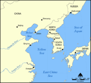
| The Yellow Sea/West Sea, showing surrounding countries. | |||||||
| Chinese name | |||||||
| Chinese | 黄海 | ||||||
| Literal meaning | yellow sea | ||||||
|
|||||||
| Korean name | |||||||
| Hangul | 황해 or 서해 | ||||||
| Hanja | 黄海 or 西海 | ||||||
| Literal meaning | yellow sea or west sea | ||||||
|
|||||||
The Yellow Sea (Chinese: 黄海) is the name given to the northern part of the East China Sea, which is a marginal sea of the Pacific Ocean. It is located between mainland China and the Korean peninsula. Its name comes from the sand particles from Gobi Desert sand storms that turn the surface of the water golden yellow during sunset and can be seen while sailing or flying west. In North Korea and South Korea, the sea is sometimes called the West Sea.
The innermost bay of the Yellow Sea is called the Bohai Sea (previously Pechihli Bay or Chihli Bay). Into it flow both the Yellow River (through Shandong province and its capital Jinan) and Hai He (through Beijing and Tianjin).
The Yellow Sea is one of four seas named in English after common colour terms — the others being the Black Sea, the Red Sea and the White Sea.
Contents |
Geography
Extent
The International Hydrographic Organization defines the limits of the Yellow Sea or "Hwang Hai" as follows:[1]
On the South. The parallel of 33°17' North from Saisyu To (Quelpart) [now known as Jeju-do] to the mainland [of China].
On the Southeast. From the Western extreme of Quelpart to Ka Nyo or West Pinnacle Island (34°13'N) in the Mengoru Group, thence to the North point of Oku To (34°22'N), to the West point of Small South Stone Island (Syo-Zyonan To) and the North point of Great South Stone Island (Zyonan To) (34°24'N) to a point on the coast of Tin To (34°25'N) along the Northwest coast of this island to the North point thereof, and thence on a line in a Northeasterly direction to the mainland of Tyosen (Korea).
Physiography
The Yellow sea, excluding the Bohai, has an area of 380,000km². Its mean depth is only 44m, with a maximum depth of 152m.[2] The sea is a flooded section of continental shelf, that formed after the last ice age (some 10,000 years ago) as sea levels rose 120m to their current levels.[2]
Environment
The intertidal mudflats of the Yellow Sea are of great importance for migratory waders or shorebirds. Surveys show that the area is the single most important site for migratory birds on northward migration in the entire East Asian - Australasian Flyway, with a minimum number of two million birds passing through at the time, with about half that number using it on southward migration.[3][4]
Transportation
A number of important sea ports of China and Korea are located on the Yellow Sea.
The Bohai Train Ferry provides a shortcut between the Liaodong Peninsula and Shandong...
See also
- Geography of China
- Geography of North Korea
- Geography of South Korea
- Battle of the Yellow Sea
References
- ↑ "Limits of Oceans and Seas, 3rd edition". International Hydrographic Organization. 1953. http://www.iho-ohi.net/iho_pubs/standard/S-23/S23_1953.pdf. Retrieved 7 February 2010.
- ↑ 2.0 2.1 Yellow Sea
- ↑ Barter, M.A. (2002). Shorebirds of the Yellow Sea - importance, threats and conservation status. Wetlands International Global Series 9. International Wader Studies 12. Canberra.
- ↑ Barter, M.A. (2005). Yellow Sea - driven priorities for Australian shorebird researchers. pp.158-160 in: "Status and Conservation of Shorebirds in the East Asian - Australasian Flyway". Proceedings of the Australasian Shorebird Conference, 13-15 December 2003, Canberra, Australia. International Wader Studies 17.. Sydney.
External links
- Sand storm over Yellow Sea, nasa.gov
|
|||||
|
||||||||||||||||||||