Bærum
| Bærum kommune | |||
|---|---|---|---|
| — Municipality — | |||
 |
|||
|
|||
 |
|||
| Coordinates: | |||
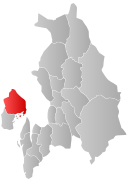
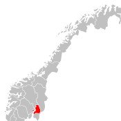
| Country | Norway | ||
| County | Akershus | ||
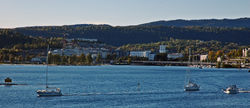
| Administrative centre | Sandvika | ||
| Government | |||
| - Mayor (2005) | Odd Reinsfelt (H) | ||
| Area | |||
| - Total | 192 km2 (74.1 sq mi) | ||
| - Land | 189 km2 (73 sq mi) | ||
| Area rank | 334 in Norway | ||
| Population (2007) | |||
| - Total | 108 582 | ||
| - Rank | 5 in Norway | ||
| - Density | 547/km2 (1,416.7/sq mi) | ||
| - Change (10 years) | 9.8 % | ||
| Demonym | Bæring[1] | ||
| Time zone | CET (UTC+1) | ||
| - Summer (DST) | CEST (UTC+2) | ||
| ISO 3166 code | NO-0219 | ||
| Official language form | Bokmål | ||
| Website | baerum.kommune.no | ||
|
|
|||
Bærum is a municipality in Akershus county, Norway. The administrative centre of the municipality is the town of Sandvika. Bærum was established as a municipality on 1 January 1838 (see formannskapsdistrikt). A suburb of Oslo, Bærum is located on the coast west of the city. Bærum has the highest per capita income in Norway[2] and the highest proportion of university-educated individuals.[3] Bærum, particularly it's eastern neighbourhoods bordering West End Oslo, is one of Norway's priciest and most fashionable residential areas, leading Bærum residents to be frequently stereotyped as snobs in Norwegian popular culture.
Contents |
General information
Name
The name (Old Norse: Bergheimr) is composed of berg which means "mountain" and heimr which means "homestead" or "farm". It has probably originally belonged to a farm located at the base of the prominent mountain of Kolsås. In Old Norse times, the municipality was often called Bergheimsherað meaning "the herað (parish/ district) of Bergheimr"[4].
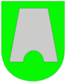
Coat-of-arms
The coat-of-arms is from modern times. They were granted on 9 January 1976. The arms show an old silver-colored lime kiln on a green background. This was an important aspect of the local economy from the Middle Ages until around 1800. There are still some original ovens visible in the municipality.[5]
History
The area known today as Bærum was a fertile agricultural area as far back as the Bronze Age, and several archeological finds stem from the Iron Age. The first mention of the name is from the saga of Sverre of Norway, from about 1200. There are ruins of stone churches from the 1100s at Haslum and Tanum.[6]
The pilgrim road to Trondheim that was established after 1030 went through Bærum, and there is evidence that lime kilns were in use in the area in 850. There were shipping ports for the quicklime at Slependen and Sandvika. The lime kiln is the main motif for the municipality's coat of arms.[6]
In the 1600s, iron ore was discovered in Bærum and the ironworks at Bærums Verk were founded. Industries such as paper mills, nail factories, sawmills, glassworks, and brickworks were established along the rivers Lysakerelven and Sandvikselva in the following centuries. There were orchards and other agricultural concerns throughout the area, remnants of which still exist today[6].
A number of artists established themselves in Bærum, particularly around the art school run by Johan Fredrik Eckersberg. Among the artists who did much of their work in Bærum are Frits Thaulow, Christian Skredsvig, Harriet Backer, Kitty Lange Kielland, Otto Sinding, Eilif Pettersen, Gerhardt Munthe, and Erik Werenskiold[6].
Starting in the mid-20th century, Bærum's agricultural base gradually gave way to residential construction. Still, only a third of the area, 64 square kilometres (24.7 sq mi), is built up for residential use; over half is productive forestry; and nearly 17 square kilometres (6.6 sq mi) is still agricultural.[7]
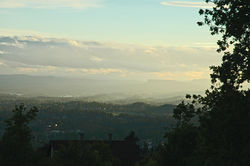
Geography
The physical geography of Bærum is dominated by a craggy coastline along the Oslofjord and inland, hilly areas rising to the north and east, where there are large forested areas. The mountain of Kolsås forms a natural center, but the municipality also includes the secluded valley of Lommedalen. Four major rivers flow through the municipality: Lysakerelven, Sandvikselva, Lomma, and Øverlandselva, and there are numerous lakes, both in residential and forested areas. The official municipality flower is Anemone ranunculoides.[4]
The geology of Bærum is part of the Oslo Graben and includes Rhomb porphyry at Kolsås.[8]
Since nearly two-thirds of Bærum's area consists of forests, there are rich opportunities for outdoor activities, such as skiing, hiking, and fishing. The forests are considered part of Marka, the forested areas in and around Greater Oslo. Areas within the municipality of Bærum include Bærumsmarka, Vestmarka, and Krokskogen.[9][10][11]
The highest point in Bærum is Vidvangshøgda at with an altitude of 552 metres (1,811 ft). The largest lake is Stovivatnet with an area of 0.420 square kilometres (0.162 sq mi) at [6]
Economy
Bærum's industrial base has since the 1950s given way to service industries, including retailing, engineering, public services, etc. It derives much of its tax base by being a bedroom community to Oslo. It is one of the most affluent areas in Norway.[4]
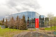
Two of Norway's busiest highways (E18 and E16) and one railroad traverse the municipality. There has been considerable development of office parks along E18, especially around Lysaker in the last 20–30 years, reducing some of the pressure on downtown areas of Oslo.[4]
Scandinavian Airlines System Norway has its offices in Fornebu, Bærum.[12] The airline Widerøe has some administrative offices in Lysaker, Bærum.[13] Norwegian Air Shuttle has its head office in Fornebu.[14]

Partnair, a charter airline, was headquartered at Fornebu Airport.[15] When the airline Busy Bee of Norway existed, its head office was on the grounds of Fornebu Airport.[16] Braathens and SAS Braathens had their head office facilities in a building on the grounds of Fornebu Airport. In 2010 Norwegian Air Shuttle bought the former Braathens head office.[17]
Demographics
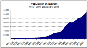
As of 2009, Bærum is the fifth most densely populated municipalities in Norway. Along the E18 highway, the residential area is continuous with Oslo and continues with some interruption through to the neighboring municipality of Asker[18].
Bærum is also the most affluent of Norwegian municipalities, with average per capita income (2002 figures) of NOK 370,800; compared with the national average of NOK 262,800. It also has the highest level of education nationwide.
Administratively, Bærum is divided into 22 sections. The population for each section on 1 January 2005 was:
|
|
Sports
Stabæk IF plays in Tippeligaen, the highest division for mens football in Norway.
Høvik IF plays in the highest bandy division.
Notable residents
- Princess Märtha Louise of Norway
- Finn Alnæs (1932–1991), writer
- Harriet Backer (1845–1932), painter
- Herman Bang (1857–1912), Danish writer
- Jo Benkow (born 1924), politician
- Gro Harlem Brundtland (born 1939), politician and former prime minister
- Hans Petter Buraas (born 1975), Alpine skier
- Ivo Caprino (1920–2001), filmmaker
- Magnus Carlsen (born 1990), chess player
- Harald Eia (born 1966), comedian
- Viktor Esbensen (1881–1942), Whaler, Explorer
- Kjell Hallbing (1934–2004), writer
- Kitty Lange Kielland (1845–1932), painter
- Claude Monet (1840–1926), painter, stayed in Sandvika for two months in the winter of 1895. His most famous painting from his stay is probably one of Sandvika featuring the Løkke bridge, with Kolsås in the background.
- Fridtjof Nansen (1861–1930), Zoologist, Explorer, Scientist, Diplomat, Nobel Peace Prize, League of Nations High Commissioner
- Eilif Peterssen (1852–1928), painter
- Vebjørn Sand (born 1966), artist
- Jan Tore Sanner (born 1965), politician
- Anita Skorgan (born 1958), singer
- Bjørn Einar Romøren (born 1981), ski jumper
- Tom Hilde (born 1987), ski jumper
- Harcharan Chawla (1926–2001), writer
International relations
Twin towns — Sister cities
The following cities are twinned with Bærum:[19]
 - Frederiksberg, Region Hovedstaden, Denmark[20]
 - Hafnarfjörður, Iceland
 - Hämeenlinna, Tavastia Proper, Finland
 - Tartu, Tartumaa, Estonia
 - Uppsala, Uppsala län, Sweden
References
- Notes
- ↑ "Personnemningar til stadnamn i Noreg" (in Norwegian). Språkrådet. http://www.sprakrad.no/Sprakhjelp/Rettskriving_Ordboeker/Innbyggjarnamn.
- ↑ "Skattelister 2008" Oslo: NRK 2009 http://www.nrk.no/skattelister2008/
- ↑ "Næringsliv" Sandvika: Bærum kommune https://www.baerum.kommune.no/Organisasjonen/Radmannen/Naringsliv/
- ↑ 4.0 4.1 4.2 4.3 Thorsnæs, Geir; Svein Askheim. "Bærum" (in Norwegian). Store norske leksikon. http://www.snl.no/B%C3%A6rum.
- ↑ Norske Kommunevåpen (1990). "Nye kommunevåbener i Norden". http://www.ngw.nl/int/nor/b/baerum.htm. Retrieved 2008-12-18.
- ↑ 6.0 6.1 6.2 6.3 6.4 Bakken, Tor Chr., ed. (2008) (in Norwegian) Asker og Bærum-leksikon Oslo: Kunnskapsforlaget ISBN 978-82-573-1534-4
- ↑ "Bærum i tall" (in Norwegian) Bærum kommune https://www.baerum.kommune.no/Om-Barum/Barum-i-tall1/. Retrieved 2010-01-02
- ↑ "På vulkansk jord". Asker og Bærums Budstikke (Sandvika). 2007-02-20. http://www.budstikka.no/sec_forbruker/sec_turstikka/article143384.ece. Retrieved Norwegian.
- ↑ "Bærumsmarka" (in Norwegian) Skiforeningen http://www.skiforeningen.no/markadb/showarea.cgi?id=1. Retrieved 2009-01-02
- ↑ "Vestmarka/Asker Syd" (in Norwegian) Skiforeningen http://www.skiforeningen.no/markadb/showarea.cgi?id=10. Retrieved 2009-01-02
- ↑ "Krokskogen" (in Norwegian) Skiforeningen http://www.skiforeningen.no/markadb/showarea.cgi?id=4. Retrieved 2009-01-02
- ↑ "SAS head office in Norway." Scandinavian Airlines System. Retrieved on 8 June 2009.
- ↑ "Headquarters." Widerøe. Retrieved on 15 November 2009.
- ↑ "Contact us." Norwegian Air Shuttle. Retrieved on 24 February 2010.
- ↑ "World Airline Directory." Flight International. 26 March 1988. 102.
- ↑ "World Airline Directory." Flight International. 27 March-2 April 1991. 78.
- ↑ Henriksen, Øyvind. "Kjos kjøper Braathensbygget." E24. 24 February 2010. Retrieved on 24 February 2010. "Norwegian-sjef Bjørn Kjos kjøper det tidligere hovedkvarteret til Braathens og SAS Norge. Nå skal Norwegian flytte inn i bygningen" and "Oksenøyveien 3 på Fornebu utenfor Oslo er kjøpt av Bjørn Kjos og Bjørn Kise."
- ↑ "Rangeringsliste for innbyggere per areal" (in Norwegian) Norges Kommunekalender http://www.norgeskommunekalender.no/index.php?cmd=nkk_analyze&type=innbyggere+pr+areal&ranging=++Ranger++&fix=nkk, the four municipalities with greater density being: Stavanger, Oslo, Oppegård, and Skedsmo. All but Stavanger form the conurbation with Oslo
- ↑ "Vennskapskommuner". Bærum kommune. https://www.baerum.kommune.no/Om-Barum/Vennskapskommuner. Retrieved 2008-12-18. (Norwegian)
- ↑ "Frederiksberg Municipality - Twin Towns" (in Danish). ©2007 -2009 Frederiksberg Municipality. http://www.frederiksberg.dk/PolitikOgDemokrati/PolitikkerOgStrategier/Samarbejde/InternationaleSamarbejder/Venskabsbyer.aspx. Retrieved 2009-09-09.
External links
- Municipal fact sheet from Statistics Norway
- Akershus travel guide from Wikitravel
- Municipality of Bærum official web site (Norwegian)
- Tourist information from the municipality of Bærum
- IT Fornebu (Norwegian)
- Weather forecast and map for Bærum (Norwegian)
- Budstikka (local newspaper for Asker and Bærum) (Norwegian)
- Page featuring Monet's paintings from Norway
|
|||||||
|
|||||||
|
||||||||||||||||||||||||||||