Akershus
| Akershus fylke | |||
|---|---|---|---|
| — County — | |||
|
|||
 |
|||
| Country | Norway | ||
| County | Akershus | ||
| Region | Østlandet | ||
| County ID | NO-02 | ||
| Official language form | Bokmål | ||
| Administrative centre | Oslo | ||
| Government | |||
| - Governor | Hans J. Røsjorde Fremskrittspartiet (1998–present) |
||
| - County Mayor | Nils Aage Jegstad Høyre (2007–present) |
||
| Area(#16 in Norway, 1.50% of Norway's land area) | |||
| - Total | 4,918 km2 (1,898.9 sq mi) | ||
| - Land | 4,579 km2 (1,768 sq mi) | ||
| Population (2008) | |||
| - Total | 523,272 | ||
| - Density | 107/km2 (277.1/sq mi) | ||
| - Change (10 years) | 13.7 % | ||
| - Rank in Norway | 2 (10.67% of nation) | ||
| Time zone | CET (UTC+01) | ||
| - Summer (DST) | CEST (UTC+02) | ||
| Income (per capita) | 182,400 NOK | ||
| GDP (per capita) | 228,868 NOK (2001) | ||
| National Rank: | 3 (7.12% of nation) | ||
| Website | www.akershus.no | ||
|
|
|||

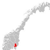
Akershus is a county in Norway, bordering Hedmark, Oppland, Buskerud, Oslo and Østfold; it has also a short border with Sweden (Värmland). Akershus is the second largest county by population after Oslo, with more than half a million inhabitants. The county is named after Akershus Fortress. The county administration is in Oslo, which is not part of the county per se.
| Historical populations | ||
|---|---|---|
| Year | Pop. | %± |
| 1951 | 183,116 | — |
| 1960 | 226,948 | 23.9% |
| 1970 | 312,235 | 37.6% |
| 1980 | 366,673 | 17.4% |
| 1990 | 414,503 | 13.0% |
| 2000 | 467,052 | 12.7% |
| 2010 | 536,562 | 14.9% |
| 2020 | 615,871 | 14.8% |
| 2030 | 692,326 | 12.4% |
| Source: Statistics Norway[1]. | ||
Contents |
Geography
The county is conventionally divided into the traditional districts Follo and Romerike, which fill the vast part of the county, as well as the small exclave west of Oslo that consists of Asker and Bærum. This became the result after the transferring of the great municipality of Aker (surrounding Oslo) from Akershus county to Oslo in 1948.
Embracing numerous suburbs of Oslo, notably Bærum, Akershus is one of the most densely populated areas in the country. The main national railway lines into Oslo run through Akershus with many junctions and stations such as Asker, Sandvika, Ski and Lillestrøm. Akershus includes some of the lake Mjøsa and some of the river Glomma.
The county also includes the historical place Eidsvoll, 48 km north of Oslo, in which the National assembly voted the Norwegian constitution in 1814. South of Eidsvoll is the international airport of Oslo Airport at Gardermoen. The estate of the crown prince is located in Asker.
Infrastructure
The county has a major international airport, the Oslo Airport, Gardermoen. It also has two hospitals, Akershus University Hospital and Sunnaas Hospital.
History
Akershus became a fief in the 16th century, and then also included the current counties of Hedmark, Oppland, Buskerud and Oslo, as well as the municipalities of Askim, Eidsberg and Trøgstad in the county of Østfold. In 1662 Akershus became an Amt, and in 1685 Buskerud was separated from Akershus and became an Amt of its own. In 1768 Hedmark and Oppland were also separated from Akershus to become Oplandenes Amt (and Askim, Eidsberg and Trøgstad were transferred to Østfold). In 1842 the city of Christiania (Oslo) was made a separate Amt as well. In 1919 the name Amt was changed to Fylke. In 1948 Aker, the greatest and the most populous municipality of Akershus, was transferred to county of Oslo.
The name
The county is named after Akershus Fortress. The fortress was built in 1299, and the meaning of the name is "the (fortified) house of (the district) Aker". The name is actually misleading nowadays, since the fortress today lies outside Akershus (since 1842 in the county of Oslo). In fact, the administration of Akershus meets outside the county as well (in the center of Oslo).
Coat-of-arms
The coat-of-arms is from modern times (1987). It shows a gable from Akershus fortress.
Municipalities
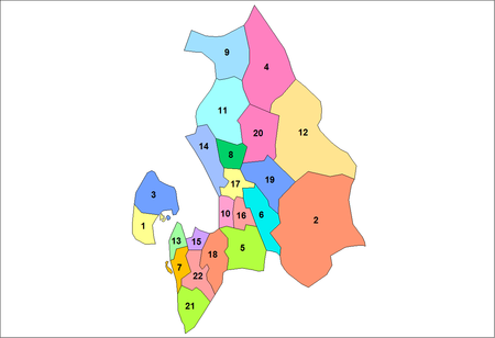
Akershus has a total of 22 municipalities:
|
External links
|
|||||||