Dudley
| Dudley | |
 Dudley
|
|
| Population | 194,919 (2001 Census) |
|---|---|
| OS grid reference | |
| - London | 130.5 m |
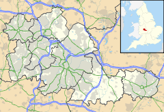
| Metropolitan borough | Dudley |
| Metropolitan county | West Midlands |
| Region | West Midlands |
| Country | England |
| Sovereign state | United Kingdom |
| Post town | DUDLEY |
| Postcode district | DY1, DY2 |
| Dialling code | 01384 |
| Police | West Midlands |
| Fire | West Midlands |
| Ambulance | West Midlands |
| EU Parliament | West Midlands |
| UK Parliament | Dudley North |
| Dudley South | |
| List of places: UK • England • West Midlands | |
Dudley (pronunciation) is a large town in the West Midlands, England, with a population of 194,919. Since 1974 it has been the administrative centre of the wider Metropolitan Borough of Dudley; the original County Borough had undergone a lesser expansion in 1966. It is the 19th largest settlement in England measured by Urban Sub-Area, the second largest town in the United Kingdom, behind Reading[1] and the largest settlement in the UK without its own university.
Dudley is part of the West Midlands conurbation, and is located south of Wolverhampton. It is the largest town in the Black Country. For many years the town (but not the castle) formed part of an exclave of Worcestershire entirely surrounded by Staffordshire[2] - which has determined the fact that, in ecclesiastical terms, it has remained part of the Anglican Diocese of Worcester.
Contents |
History
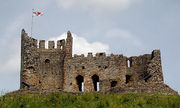
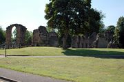
Dudley has a history dating back to medieval times. Dudley Castle has stood on a hill overlooking the town since the 11th century,[3] and is mentioned in the Domesday Book.[4] The present castle dates from the 13th century, and provided the centre around which the town grew. Dating from the 12th century are the ruins of St James Priory, set within the Priory Park.[5]
The town industrialised rapidly in the 18th and 19th centuries, and its population grew dramatically. Due to its heavy and highly polluting industries it became a central part of the Black Country. The main industries in Dudley included coal and limestone mining.[6] Other industries included iron, steel, engineering, metallurgy, glass cutting, textiles and leatherworking. Most of these industries have declined in recent decades.
Of historical significance, the first Newcomen steam engine was installed at the Conygree coalworks a mile east of Dudley Castle in 1712.[7]
Dudley was a predominantly rural town as recently as the early 18th century, after which the Industrial Revolution saw many factories and coalpits open up around the town as well as houses for the workers to live in were being built. Further development took place in the 19th century. The lack of clean drinking water and proper sewers led to Dudley being declared 'the most unhealthy place in the country' in 1852 with an average age at death of 16 years and 7 months (compared to an average of 29 years 4 months for all England and Wales).[8]
Many of the houses built for industrial workers in Dudley were in a sub standard condition by the turn of the 20th century and mass demolition of the town centre slums began in the 1920s, accelerating in the 1930s. The occupants of the slums were rehoused on modern council housing developments including the large Priory and Wren's Nest housing estates as well as smaller developments in areas such as Woodside and Kates Hill. Substantial private housing was built at this time as well.
During World War II, Dudley was bombed on several occasions, with a number of fatalities, though nowhere near as severely as its near neighbour Birmingham.
The first major council housing development was the Priory Estate, where more than 2,000 houses were built between 1929 and 1939.[9] The Wrens Nest Estate followed soon afterwards. It stands in the shadow of Wrens Nest Hill, where many Silurian fossils can be found including crinoids, corals and trilobites.
The Castle Hill area of the town was heavily developed for entertainment attractions in the first 40 years of the 20th century. An Opera House was opened there in 1899, followed a year later by the Station Hotel (rebuilt in the 1930s) opposite. The Opera House was destroyed by fire in December 1936 and replaced by a Plaza cinema. By this stage, a Hippodrome Theatre opened next door. An Odeon cinema opened on the opposite side of the road at around the same. However, the postwar decline in cinema and theatre attendance - brought on by the rising popularity of home television - affected the area greatly. The Hippodrome closed in 1966, and has been used for several purposes - most recently by Gala Bingo. The Odeon closed in 1976 and was converted into a Jehovah's Witnesses Kingdom hall. The Plaza closed in 1990 and was briefly used as a Laser Quest laserdome until its demolition in 1997. [1]
After the war was over, thousands of sub standard properties remained, and the clearance and rehousing continued in the 1950s and was almost complete by the early 1960s. The postwar years saw the development of further new council housing estates including Russells Hall and Old Park Farm. The 1960s saw the construction of 11 multi storey blocks of council flats in Dudley - the tallest three of them at Eve Hill, and smaller blocks at Grange Park, Queens Cross and Netherton.
The nearby village of Lower Gornal was the epicentre for the Dudley earthquake of 2002, the largest earthquake to hit the United Kingdom in nearly 10 years.[10]
The town centre is a mix of old and modern buildings, with some surviving from as far back as the 18th century, while others were built in the second half of the 20th century. Modern shopping developments include the Churchill Shopping Preicint (opened in 1969 and named after the late prime minister Sir Winston Churchill who died four years earlier) and the indoor Trident Centre which opened around the same time. The Churchill Shopping Preicint was originally an open-air centre owned and run by the local council, only to be sold to a private company in 1991 - within two years a substantial refurishment of the preicint had been completed, which included a roof being fitted.
Most of the town's multiple stores were situated on Market Place and High Street. However, the development of the Merry Hill Shopping Centre four miles away at Brierley Hill during the second half of the 1980s saw most of the multiple stores (including Marks and Spencer and British Home Stores) relocate from Dudley and predominantly replaced by discount stores. The financial crisis and recession which has hit Britain and most of the rest of the world since 2007 has resulted in many of the retail units in Dudley town centre becoming vacant. The Woolworths store on Market Place closed in December 2008 when the company went bankrupt, and has been replaced by an indoor market, though few of the other stores which became vacant around the same time have been reoccupied.
Civic history
By the end of the thirteenth century, Dudley had become a manorial borough [11]. Before 1791, Dudley was governed by the Court Leet of the Lords of Dudley. Between 1791 and 1852, the Town Commissioners were the principal local authority. The Town Commissioners were superseded in 1853 by the Board of Health. Dudley became a municipal borough in 1865. In 1889, it became a County Borough. The County Borough of Dudley included the town of Dudley and the villages of Woodside and Netherton. In the 1961 census, the County Borough had a population of 62,965.[12]
Dudley's Council House in Priory Road was opened in 1935 by King George V. It was financed by the then Earl of Dudley, William Humble Eric Ward, who stipulated that when the Mayor is seated at the head of the council chamber he should have a direct line of sight to Dudley Castle once all the chamber doors are thrown open (Source: 'Dudley's Little Book of Big History', Dudley MBC publication, 2008)
In 1966, the county borough was expanded to include the majority of the urban district councils of Brierley Hill and Sedgley, about half of Coseley along with small areas of Amblecote and Rowley Regis, as well as a fragment of rural Seisdon.[13] As the majority of these areas were part of Staffordshire, Dudley was transferred from Worcestershire to the county of Staffordshire. Part of the Oakham area of the town was transferred into Warley County Borough. These changes meant that the population of Dudley County Borough at the time of the 1971 census increased to 185,592;[12] an increase of almost 300% from the 1961 figure.
Dudley's borough boundaries were further expanded in 1974 to become a Metropolitan Borough, having taken in the boroughs of Halesowen and Stourbridge (both formerly in Worcestershire). This meant a further increase in population, which by the time of the 1981 census was 298,511[14] - an increase of five times the population of only twenty years before.
Since 1974, Dudley has been part of the West Midlands county.
Places of interest
The town is home to Dudley Zoo, and the Black Country Living Museum. Visitors to the museum may also take a narrowboat trip from the adjacent canal, through the Dudley Tunnel. The ruined Dudley Castle is within the grounds of the zoo, and there is an extensive wooded ridge that runs north from the castle. Dudley Zoo is to be regenerated under proposals by Dudley Zoo in partnership with Dudley Council, St Modwen and Advantage West Midlands, which will see a former freightliner site redeveloped with a tropical dome, Asiatic forest, two aquatic facilities and walkthrough aviaries. It is expected to cost £38.7 million.[15]
Dudley is home to a former Odeon Cinema and a former music hall, the Dudley Hippodrome, both from the Art Deco period in the 1930s. The Dudley Hippodrome was built on to the side of the now-demolished Opera House (built in 1900 and burnt down in 1936) and is now a bingo hall. There is a Showcase Cinema in a retail park between the zoo and museum.
The Odeon Cinema became an Assembly Hall for the Jehovah's Witnesses in 1976 for the West Midlands Area.
The Plaza Cinema was built on Castle Hill in 1938 next to the Hippodrome, and remained open until October 1990. The building was then taken over by Laser Quest, who used it until it was demolished in 1997. The site of the cinema remains undeveloped.
Since the 1970s, there has been a nightclub on Castle Hill situated on the corner of Station Drive; this has changed ownership several times since first opening.
There are many canals in and around Dudley, the main one being the Dudley Canal - most of which passes beneath Dudley in a tunnel which lacks a towpath and is therefore accessible only by boat.
The open sections of canal are popular with walkers, cyclists, fishermen, and narrowboat users.[16] Many of the canalside towpaths have been upgraded for cycling, and some sections are part of the National Cycle Network.
The Wren's Nest National Nature Reserve is a site of special scientific interest (SSSI) considered to be one of the most notable geological locations in the British Isles and home to the Calymene blumenbachi trilobite nicknamed the Dudley Bug or Dudley Locust by 18th century quarrymen. Dudley Museum and Art Gallery has a large collection of its well-preserved Silurian coral reef fossils, plus numerous displays relating to the history of the town.[17]
Established in 1260, Dudley Market in Dudley town centre is a major shopping area for the town. It has undergone numerous developments in its history. One major development was in 1982 when the area was pedestrianised and the 12th century cobblestones were removed. Other developments have included the addition of a new roof and new toilet facilities, with the new ground level block having replaced underground toilets in the early 1990s.[18]
Dudley is also the location of several churches. These include the Church of St. Edmund, Church of St. James, and Church of St. Thomas.
The old St Edmund's Church School, a 19th century building near the town centre, was closed in 1970 on a merger with St John's Church School on Kates Hill, and later converted into a mosque for the town's growing Islamic community, which is mostly concentrated around Kates Hill, Queen's Cross, Eve Hill and The Buffery.
St James's Church at Eve Hill also had a church school from the mid 19th century, but this was closed during the 1970s and was used as a community centre for several years before being transferred to the Black Country Museum in 1989. The site of the school remained vacant until 2008, when work began on a new health centre that is due to open by 2010. [19]
Proposed Mosque
During the mid 2000s, plans were unveiled for the construction of a new mosque on the site of a derelict factory near the Dudley Southern By-Pass. The idea of this new facility has been in the pipeline since Muslim leaders declared the current facility at Castle Hill too small for the congregation. The current site, formerly St Edmunds School House is a grade II listed building, with little scope of adaption. The current mosque on Castle Hill, a converted school, has capacity for around 470 worshippers and has been in use since 1978. The new mosque will increase the capacity to 750 worshipers, with a separate area for women accommodating 300 worshippers in the balcony. Underground parking has been added to the plans following consultation with local residents.[20].[21][22] The plans were shelved in early 2007 by request of Dudley Council, amid fears of racial tension in the forthcoming elections, but were revived a year later, and the controversy over the proposed mosque has attracted much heated debate from many quarters, as well as national media attention. Local residents fear the sheer size of the mosque will upset the infrastructure of the town centre and cause major traffic problems.[23]
The proposed location of the mosque is on part of the site of the former Goodyear Tire and Rubber factory, which closed in the early 1990s and was demolished soon after, with the bulk of the site being occupied by the Dudley Southern By-Pass which opened in 1999. The application for outline planning permission was recommend by approval by council officers, but then rejected by the elected officials of Dudley Council's development control committee in 2007. The following year outline planning was granted on appeal to the Planning Inspectorate. Dudley Council appealed against the decision and the case was heard at the High Court in July 2009. In March to April 2010, there were many arguments about building the Mosque. There was a big protest in Dudley Town Centre about the argument.
After high court action, which cost taxpayers around £16,000; the appeal from Dudley council was rejected, with the hearing finishing mid afternoon, on the first day of a predicted two day hearing.[24] In July 2009 the judge backed plans for the mosque and community centre to be built on the condition that it will be open to all members of the community. The Planning Inspectorate also stated it should be "accessible and available to the whole community."[25] The completion cost is estimated to be ₤18 Million.
Dudley Mosque is a strong member of the Dudley Borough Interfaith Network [26] who have posted a Fact-Check[27] about the proposed Mosque. Black Country Church leaders have called for Wisdom and Grace in peoples response to the mosque.[28]
The controversy over the proposed Mosque has attracted attention from the English Defence League, who protested in Dudley on 4 April 2010 against the proposed construction of a new Mosque.[29]Dudley Council have estimated the total cost to the taxpayer of the EDL protest at £500,000, and a loss of trade of £250,000 by local traders.[30] Despite violence by EDL protesters, and a break-out from the protest area,[31] the massive police operation was able to contain the protesters, with Police hailing the operation a success.[32] The leaders of all the elected political parties in Dudley joined together to condemn the protest, and ask the EDL to stay away,[33] and faith leaders joined with leaders from the Voluntary Sector, Council, Police and Fire in signing a 'One Borough Pledge', committing to continue working together for the benefit of the local community.[34][35]
The mosque proposals were scrapped on 3 May 2010 in favour of an expansion to the existing Dudley Central Mosque on Castle Hill.[36] This came the day after two English Defence League members were arrested for staging a rooftop protest at the remaining former Goodyear warehouse on the site of the proposed mosque.[37]
Ethnic unrest
Racial tension, between various ethnic communities, has been high in Dudley since the first Commonwealth immigrants settled in the town just after the end of the Second World War, though it has undoubtedly reached its height since the mosque project was first announced.
Dudley was the scene of some of Britain's first race riots in July 1962, when dozens of white men and youths rampaged in the North Street area of the town, vandalising properties in the area where the town's ethnic minorities were concentrated. Black Caribbean immigrants were particularly targeted in these disturbances.
Another racially motivated riot, though less well known than the North Street riots, took place in Dudley in September 1991, when white and Asian youths clashed in the Kates Hill area.[38]
The English Defence League demonstrated in the town centre on 3 April 2010; although there were no injuries, eight people were arrested and there were several instances of criminal damage. A second demonstration is set to take place on 17 July.[39]
The English Defence League again demonstrated against the mosque project on 17 July 2010. There were severe confrontations at many levels with the result that 20 criminal offenses[40] were being investigated by police during the aftermath, and many accounts of severe personal injury of visiting protesters were reported.[41]
Politics
National government
Dudley is covered by two parliamentary constituencies, Dudley South and Dudley North, which also represent some other towns within the Metropolitan Borough of Dudley. The current MPs elected from these seats and to the House of Commons are Ian Pearson and Ian Austin respectively. Both represent the Labour party.
Local Government
Dudley Metropolitan Borough Council is a 4-star unitary authority run by the Conservative Party. The Leader of the Council is Cllr Anne Millward.
In May 2009, there was condemnation of councillors for voting themselves a 25% increase in their expenses and allowances.
Other
Law enforcement in Dudley is carried out by the West Midlands Police and fire and rescue by the West Midlands Fire Service.
Dudley Police Station is situated on New Street, in a building that opened in 1939 to replace a 19th century structure on Priory Street which now forms part of the local council offices.
The Fire Station is situated on Burton Road, where it relocated to from a 1930s building on Tower Street. Part of the current site was previously occupied by Burton Road Hospital.
The current Ambulance Station was opened in the late 1980s on Burton Road, on part of land that formed the site of the hospital six years before its demolition.
Libraries
In 2008 Dudley Council commenced a project it called "modernisation", but was widely regarded as a closure programme. As a result five libraries: Quarry Bank, Dudley Wood, Amblecote, Wall Heath and Woodside were closed.
Transport
Rail
The nearest railway stations are all a mile or more from Dudley town centre; Tipton railway station and Dudley Port railway station are served by local services operated by London Midland, and Sandwell and Dudley railway station which is served by both local London Midland services and Virgin Trains West Coast services from London Euston to Wolverhampton.
Dudley railway station, in the town of Dudley itself, opened in 1850, and closed under the Beeching Axe in 1964. In its heyday it was a hub of services east to Birmingham (via a junction at Great Bridge), Walsall and Lichfield; north to Wolverhampton, Tipton and Coseley; and south-west to Stourbridge, as well as a line that served the small communities on the way to Old Hill and Halesowen. This site was then used as a Freightliner terminal by Freightliner UK until an unpopular closure on 26 September 1989.[42]
Both of the town's railway stations (Dudley and Blowers Green) were closed in 1962 under the Beeching Axe, although the line through Dudley remained open to goods trains until 1993. In the early 2010s the town is set to regain a rail link for the first time in almost half a century when an extension to the Midland Metro opens between Brierley Hill and Wednesbury, although the Midland Metro is a Light Rail system, and does not feature through ticketing to the national rail network.[43]
Bus
There is a large bus station on the outskirts of the town centre which has many connections to surrounding towns and communities, including: Bilston, Birmingham, Brierley Hill, Coseley, Cradley Heath, Gornal, Halesowen, Kingswinford, Merry Hill Shopping Centre, Oldbury, Pensnett, Rowley Regis, Sedgley, Smethwick, Stourbridge, Tipton, Wall Heath, Walsall, Wednesbury, West Bromwich, Wolverhampton, Wombourne and Wordsley.
From the end of April 2008, the new Dudley Bus Network is coming into effect. This is seeing the withdrawal of several bus routes as well the introduction of several others. Those which are not changing are seeing several timetable changes.
The bus station also sees limited service from National Express, whose services call at the bus station mostly for London or Wolverhampton. Other places served include holiday destination Blackpool and London Heathrow and London Gatwick Airports. There is also a bus station at Russells Hall Hospital.
The town has been served by a bus station at the junction of Birmingham Street and Fisher Street since 1952. The original bus station was cleared in 1984 and replaced by the current bus station which became fully operational in 1987.
Originally, Midland Red operated bus services in the town, mostly from its own bus depot, which opened in 1929. This depot was located on Birmingham Road and passed to West Midlands Passenger Transport Executive in 1973, along with operation of all bus services in Dudley. The depot itself was closed in 1993 and demolished a year later to make way for the Castle Gate roundabout at the eastern end of the town's new southern by-pass. The island was built in 1997 and the by-pass opened on 15 October 1999.
Road
Dudley itself is well-served by main roads which give a direct route to neighbouring towns. The longest of these roads are the B4176 (which runs to Wombourne, Bridgnorth and Telford) and the A461 (which passes through Wednesbury and Walsall, finally reaching Lichfield).
Air
The nearest international airport is Birmingham International Airport, around 25 miles to the east. The nearest local airport is Wolverhampton Airport, which is about 10 miles to the west of the town.
Demography
| Dudley Compared | ||||
|---|---|---|---|---|
| 2001 UK Census | Dudley | Dudley MB | West Midlands conurbation | England |
| Total population | 194,919 | 305,155 | 2,284,093 | 49,138,831 |
| White | 93.5% | 93.7% | 79.6% | 90.9% |
| Asian | 3.9% | 4.0% | 13.5% | 4.6% |
| Black | 1.2% | 1.9% | 3.9% | 2.3% |
| Source: Office for National Statistics[44][45] | ||||
The 2001 Census gives the Dudley Urban Subdivision as the third most populous in the West Midlands conurbation, with a total resident population of 194,919.
Education
Primary schools
Dudley is served by a range of primary schools. Several of these are church schools. For example, Jessons Church of England Primary School, St Chads Roman Catholic School, St Edmund's and St John's Church of England Primary School and Netherton Church of England Primary School are all Church of England primary schools.
Other primary schools in the town include Priory Primary School, Kates Hill Primary School, Sledmere Primary School, Russells Hall Primary School, Milking Bank Primary School, Highgate Primary School, Northfield Road Primary School, Dudley Wood Primary School, Foxyards Primary School, Netherbrook Primary School and Blowers Green Primary School. Many of these schools are named after the housing estates they are located within.
Primary schools throughout the Dudley borough currently all provide education for pupils aged 5 to 11 years. Some schools also have nursery units for pupils aged 3 and 4 years. From 1972 to 1990 schoolchildren in Dudley, Sedgley, Coseley and Brierley Hill stayed at primary school until the age of 12. Halesowen ran a 5-13 first and middle school system from 1972 to 1982, while Stourbridge and Kingswinford have always had a traditional 5-11 infant and junior system.
Wrens Nest Primary School
Wrens Nest Primary School is a primary school that was built in 1936 to serve the new council housing estate which was being built at the time. The school expanded in September 2006 to accommodate pupils transferred from the nearby Sycamore Green Primary School, which had closed due to falling numbers on the school roll. This signalled the beginning of a £6.2million rebuild of the school, with the revamped school opening on 11 June 2010 with the official opening being made by long-serving school cleaner and community worker Margaret Lenton.[2]
Secondary schools
There are four secondary schools in central Dudley. Castle High School is a visual arts college and secondary school. It was formed as a result of a merger between The Dudley School, Sir Gilbert Claughton School and The Blue Coat School. It also occupies the buildings which once consisted of Dudley Boys Grammar School and land that was once used for Dudley Girls High School. It is one of the newest schools in the town.
Holly Hall School is comprehensive school in Dudley and has computing and mathematics college status. Bishop Milner Roman Catholic School is a Roman Catholic secondary school in Dudley. Constructed in 1958, it became one of the first Roman Catholic secondary schools in the region and is the oldest existing school in Dudley. Hillcrest School is another secondary school in Dudley, serving the community of Netherton.
Dudley traditionally ran a system of 5-7 infant, 7-11 junior and 11+ secondary schools, but in 1972 the system was altered to create 5-8 first, 8-12 middle and 12+ secondary schools - this affected the towns of Dudley, Sedgley, Coseley and Brierley Hill, while the traditional system remained in Kingswinford. Secondary modern and grammar schools were replaced by comprehensive schools in September 1975, and since that date all state secondary schools in the borough have been comprehensive.
Stourbridge, which became part of the Dudley borough in 1974, retained the traditional system as well, although Halesowen had adopted 5-9 first, 9-13 middle and 13+ secondary schools in 1972.
Halesowen reverted to the traditional 5-7 infant, 7-11 junior and 11+ secondary school system in 1982, and by 1985 there were plans afoot to return to the traditional system across the borough. The traditional system was finally restored across the Dudley borough in 1990, resulting in several secondary school buildings having to be expanded to accommodate a 25% rise in pupil capacity.
Casualties of the introduction of comprehensive education included Dudley's girls high and boys grammar schools, which merged with the nearby Park secondary modern school to form The Dudley School (which in turn became Castle High on a merger with The Blue Coat School in 1989), while the equivalent schools in Stourbridge merged with Valley Road Secondary Modern School to become Redhill School. Several other grammar schools, including the High Arcal School in Sedgley, continued merely with a change in status rather than name.
The borough's final single sex state schools, Walton Girls School and Richmond Boys School in Halesowen, merged in 1985 to form Windsor High School.
Special schools
There are three special schools within Dudley. Old Park School serves pupils from the age of 3 to 19.[46]
Rosewood School also caters for children within the age range. It was built on the Russells Hall Estate during the 1960s but relocated to the former Highfields Primary School in Coseley in March 2008.[3]
The Sutton School, built 1962, caters only for pupils from 11-16.[47]
Defunct schools
As well as The Dudley School, Sir Gilbert Claughton School and The Blue Coat School which merged to form Castle High School which also occupies the land and buildings of Dudley Boys Grammar School and Dudley Girls High School, other defunct schools in the town include Rosland Secondary School, which became part of The Blue Coat School in 1970, and Park Secondary School. Mons Hill School also shut down as a result of falling pupil numbers, it had originally opened in 1965 to replace another school; Wolverhampton Street School.
Primary schools that no longer exist include St James' School (erected in 1842), St John's Primary School and St Edmund's Primary School which both merged together to form St Edmund's and St John's Church of England Primary School in the 1970s. The St Edmund's Primary School building still exists and is currently used as Dudley Central Mosque.
Sycamore Green Primary School shut down in July 2006 following a consultation period which ended in the decision that it was no longer necessary to keep the school open as a result of falling pupil numbers. Staff and pupils were transferred to the Wrens Nest Primary School and the school buildings are currently used as a Pupil Referral Unit for students studying at Key Stage 3.
Further education
Dudley College is a college of further education and lies mainly to the north of the town centre, with further campuses at Castle View and Wren's Nest. It is Dudley's only college of further education, having opened in 1936.
Until the summer of 2002, there was a campus of the University of Wolverhampton within the town. The newer part of the campus, built during the 1960s, was retained as part of Dudley College. The older buildings, which were originally a teacher training college built in 1905, were demolished soon afterwards and the site redeveloped for private housing. Dudley is now the largest town or city in the UK without university facilities.
Medical
In October 2006, Dudley Beacon and Castle Primary Care Trust and Dudley South Primary Care Trust merged to become Dudley Primary Care Trust.[48] It is chaired by Mark Cooke.
Dudley is served by two major NHS health facilities. Dudley Guest Hospital was the first to be constructed. However it began as a charity by the Earl of Dudley to accommodate blinded local miners in 1849. The charity did not become popular and it was taken over by a local chainmaker who turned it into a hospital in 1871. As a result of the loss of the Emergency department in 1983, the hospital has become a less important facility compared with the Russells Hall Hospital, also in Dudley. A new outpatient centre opening at the Guest in 2003 but the original buildings remained use for another four years before the remaining services were transferred to Russells Hall.
Russells Hall Hospital was constructed in 1976 but financial problems meant that it could not open until 1983. A major expansion of the hospital was completed in 2005 when it incorporated all of the borough's inpatient services, following the closure of Wordsley Hospital and the downgrading of Dudley Guest Hospital and Stourbridge Corbett Hospital to outpatient services only.
Another hospital serving Dudley is Bushey Fields Hospital, which was developed in the 1980s and early 1990s.[49]
Burton Road Hospital stood on Burton Road approximately one mile to the west of the town centre, but this was not part of Dudley until 1966 having previously been in Sedgley. It was built in the mid 19th century as a workhouse and became a hospital in 1859. The hospital was demolished in 1994, having closed in December 1993.
Dudley Health Centre was opened in Cross Street in 1979. There are currently four GPs employed there, as well as numerous administration staff. There are also doctor's surgeries in Bean Road, and the clinic on the Priory Estate was demolished in the mid-2000s after serving the local community for some 70 years. Another surgery was built in the extreme west of the town (on the border with Sedgley) around 1990, to serve the new Milking Bank housing estate.
Media
Dudley is served by a number of local newspapers. The town has its own version of the Express & Star, published daily Monday to Saturday. There are also Dudley News,[50] which is published weekly, and the Black Country Bugle, which looks at the history of Dudley and the rest of the Black Country. Dudley was also served by the Dudley Evening Mail until its absorption into the Birmingham Evening Mail in late 1986. Televised local news is provided through Midlands Today and Central Tonight, which also serve the wider area of the West Midlands.
BBC Radio WM, BRMB Heart West Midlands, Kerrang! Radio, and Smooth Radio 105.7 are some of the local radio stations that can be received in Dudley, also serving the wider West Midlands.
Business and industry
The town centre is home to numerous high street retailers including River Island, Wilkinsons, Clinton Cards, WH Smith, Argos and New Look. There is also a Subway restaurant. McDonald's, British Home Stores, Marks and Spencer and Pizza Hut have all had branches in Dudley town centre in the past. Most of Dudley's shops are concentrated along the main shopping street (named High Street apart from a short length at the foot of the Castle called Castle Street)and two side streets: Stone Street and Wolverhampton Street.
Dudley Market is situated on a wide part of High Street. There are three small shopping centres or arcades with entrances on High Street: the Churchill Shopping Centre, the Trident Shopping Centre and the Fountain Arcade.
Dudley retailing was particularly hard hit by the opening of the Merry Hill shopping centre in the 1980s, losing a number of major retailers including:British Home Stores, Marks and Spencer, Sainsbury's, C&A and Littlewoods[51].
The Bean Cars factory was opened in the first years of the 20th century and remained in use until the 1930s, but survives to this day for other industrial use.
Localities
- Holly Hall - In the south-west of Dudley town, situated around the road towards Brierley Hill and Stourbridge. Local landmarks include Holly Hall School and Dudley Cemetery (the resting place of local soccer legend Duncan Edwards).
- Kates Hill - Situated on a hill to the east of the town centre. Parliamentary soldiers fired cannons from Kates Hill during the Civil War of 1648 in their attack on the Royalist garrison at Dudley Castle. When the local area was developed for housing some 200 years later, many of the local streets took their names from Parliamentary figures. The parish church and church school (though no longer in use as a school) are about the only buildings left on Kates Hill from this era, as many council houses were built between 1920 and 1980.
- Netherton - Originally a village, but now more of a small town, which has always been part of Dudley. It grew in size during the Industrial Revolution, and 150 or so years later it retains its Black Country character to a greater extent than most other local towns.
- Oakham - A suburban and mostly upmarket eastern area of the town which has mostly been developed since the 1920s, and part of which was absorbed into the County Borough of Warley (now Sandwell) in 1966. Is home to Dudley Golf Course, which since 1966 has actually existed beyond Dudley's boundaries.
- Milking Bank - A modern private residential area which was mostly developed in the 1980s on open land more than a mile west of the town centre. Was further expanded in the mid to late 1990s, mostly on land previous occupied by Burton Road Hospital, this development being known as Earls Keep.
- Russells Hall - Situated to the west of the town centre and mostly developed between 1958 and 1966 for a mix of private and council housing. Consists of one primary school and three special schools, and since 1983 has been home to Russells Hall Hospital.
- Priory Estate - Situated beyond the ancient Priory Ruins to the north of the town centre. Was developed in the 1930s with a mixture of council houses to rehouse people from town centre slums as well as a few streets of more desirable private houses. Includes a public park, primary school, shopping parade and public house. The north part of the estate, consisting of 266 homes, is due to be demolished in 2009 and will be redeveloped with more than 300 new homes.
- Woodsetton † - A village situated about two miles east of Sedgley town centre near the border with Coseley, most notable for Holden's Brewery that dates back to the 19th century and is one of the local area's biggest and best known brewers.
- Woodside - Originally a separate manor from Dudley that also bordered with Brierley Hill, but was merged into Dudley towards the end of the 19th century as new developments began along the Stourbridge Road. This is the place to be in Dudley, and in this same area, it houses what was formerly known as Highgate Primary School.
- Wren's Nest Estate - Dominated by the huge hill of the Wren's Nest National Nature Reserve that contains numerous underground caverns as well as a huge collection of fossils, which according to local legend "will never run out". The rural land beneath the hill was developed for council housing during the 1930s. By the 1980s, it was one of the most rundown and deprived estates in the West Midlands, but European Union funding in the early 1990s saw living conditions improve and many of the area's other problems solved.
- Gornalwood † - A village in the Sedgley township which was a largely rural area until the early 20th century, and has retained much of its original character despite extensive private and council housebuilding since the 1920s.
- Lower Gornal † - Another village in the Sedgley township, which is very similar to neighbouring Gornalwood and is very difficult to differentiate from its close neighbour, with the boundary between the two villages being very difficult to determine.
- Sedgley † - A town in its own right which is situated some four miles north of Dudley in the direction of Wolverhampton. Was originally a manor of villages, but developed into a town between 1920 and 1970 following extensive housebuilding in the private and public sectors.
- Upper Gornal † - A village within the Sedgley township that is situated around the main road between Dudley and Wolverhampton. As with Lower Gornal and Gornal Wood, Upper Gornal features a wide range of building types.
- Brierley Hill † - Still regarded as a separate town, and dominated by the Merry Hill Shopping Centre which was mostly developed between 1985 and 1989. For some 150 years prior to 1982, the town was dominated by the Round Oak Steel Works, which was situated on part of the site now occupied by Merry Hill.
- Coseley † - One of the local area's smaller towns, was originally part of Sedgley before becoming a town in its own right in 1897. Until its absorbment in Dudley nearly 70 years later, the town became increasingly more densely developed for housing. Its industry has declined considerably in recent decades, with the most recent major loss being the huge Bean car component factory (once the home of Bean Cars) which closed due to financial problems in 2005.
- Kingswinford † - A suburban area of the borough which was originally a parish in its own right until becoming part of Brierley Hill and finally Dudley. Unlike many other towns in the borough, it still has a very rural atmosphere despite having been extensively developed for private housing since the 1920s. Is now considered as one of the most desirable residences in the Black Country.
- Wall Heath † - A village within the Kingswinford suburban area that is among the most popular and desirable residential areas in the Black Country, and a sharp contrast to many other parts of the borough.
- Notes
- † – Areas added to Dudley County Borough in 1966. Some of these areas were split between Dudley and other County Boroughs. Those parts within the present Metropolitan Borough of Dudley are considered by the ONS to be part of the Dudley Urban Sub-Area.
Notable people
- Mick Taylor (1958-) - celebrated Business Studies and Economics academic. Also an acclaimed equestrian and UK Clay Pigeon Shooter Champion years 1998-2003 inclusive
- Sam Allardyce (1954 - ) - footballer and football manager
- John Badley (1783–1870) - surgeon of Dudley, FRCS (original 300 Fellows) Medical pioneer
- John Haden Badley (1865–1967) - educator, founder (1893) and Headmaster (1893–1935) Bedales School
- Ben Black (1889–1950) - composer
- Jim MacCool (1958 - ) Dudley's poet in residence,
- Jason Bonham (1966 - ) - son of Led Zeppelin drummer John Bonham
- David Burrows (1968 - ) - retired professional footballer who played for clubs including Liverpool, Everton and Coventry City
- Billy Dainty (1927–1986) - comedian
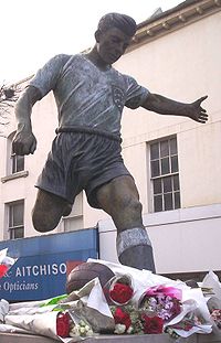
- Duncan Edwards (1936–1958) - footballer who died in the Munich Air Disaster. In 2008 the town's Southern By-Pass was renamed 'Duncan Edwards Way', in memory of him. He was buried in the town's cemetery. In 1993, a new road in Queen's Cross (Duncan Edwards Close) was named after him. A statue of him was erected in the Market Place in 1999.[4]
- Reanne Evans (1985 - ) Three-time Ladies' World Snooker Champion
- Kaleigh Grainger (1986 - ) – unicyclist
- Lenny Henry (1958 - ) - comedian
- Nigel Mazlyn Jones - musician
- Sue Lawley (1946 - ) - newsreader
- Jas Mann (1971 - ) - musician
- Ian Messiter (1920–1999) - comedy writer
- Norman Pace (1953 - ) – comedian
- Dorothy Round (1908–1982) - tennis player who won the ladies' singles at Wimbledon in 1934 and 1937.
- Percy Shakespeare (1906–1943) - artist
- Joe Smith (1889–1971) - former footballer and manager (was manager of Blackpool at the time of their famous 1953 FA Cup final victory over Bolton, dubbed the "Matthews Final")
- James Whale (1889–1957) - film director
- William Perry (boxer) (1819–1880) - Prizefighter, also known as the Tipton Slasher. Buried in St John's Churchyard, Kate's Hill.
In popular culture
- The front and inner photographs for the 1971 Led Zeppelin IV album were taken in the Eve Hill area of town; the main tower block, shown side on, is Butterfield Court, off Salop Street, and still stands today.[52] There were two other blocks in the Eve Hill area, all constructed during the 1960s, but they were both demolished in controlled explosions on 18 July 1999. Private housing, in a development known as Squire's Gate, was constructed on the site of the flats in 2002.[53]
- The borehole in local author Hugh Walter' juvenile science fiction story The Mohole Mystery was sited in Dudley.
- The television comedy series The Grimleys, though set in Dudley was filmed some 80 miles away in Salford, Greater Manchester.
- In an episode of the television comedy series Men Behaving Badly, Dudley is noted as the strangest place where Gary and Dorothy have had sex.
- In an episode of popworld, Pete Wentz claimed his favourite town in the UK was Dudley.
- Part of episode 2 of Psychoville is set in Dudley.
- In the popular video game series "Street Fighter", an English born character is named Dudley (Street Fighter) in reference.
Sport
Dudley is the largest town in England never to have had a league football club.[54] The town's key football teams, Dudley Town F.C. and Dudley Sports F.C. have never progressed beyond the Southern League. They are both currently at Level 10 of the Football League pyramid.
Dudley Town is the older of the town's two clubs, and have enjoyed the most success. Their most notable success came in 1985 when they won promotion to the Southern Premier League, but in the same year their difficulties began with their stadium situation as they were forced to quit Dudley Sports Centre (at the junction of Tipton Road and Birmingham Road) due to mining subsidence. They played at Round Oak Sports Ground in Brierley Hill for the next 11 years, and then spent a season ground-sharing at Halesowen Town, before resigning from the Southern League due to financial difficulties. The club was reformed in 1999 to compete in the West Midlands Regional League, and currently ground-share with Stourbridge at the War Memorial Athletic Ground.
In 1981, when still playing at Dudley Sports Centre, Dudley Town played a prestigious game against Wolverhampton Wanderers to commemorate a refurbishment of the stadium, with the new floodlights being switched on by legendary former Wolves player Billy Wright.
For some time after leaving Dudley Sports Centre, there were hopes that it could be made safe for Dudley Town to return, but these plans never materialised and the site was instead redeveloped as a business and leisure complex which has been developing since 2000. The club currently play at The Dell Stadium in Pensnett.
References
- ↑ Love My Town: UK Towns with Populations over 100,000 (2001 Census)
- ↑ Richardson, Eric, The Black Country as Seen through Antique Maps, The Black Country Society, 2000. ISBN 0-904015-60-2
- ↑ Dudley Metropolitan Borough Council - Dudley Castle, accessed 4 March 2007
- ↑ Encyclopaedia Britannica 1911, accessed 4 March 2007
- ↑ "Priory Ruins". Dudley Metropolitan Borough Council. 2007-09-10. http://www.dudley.gov.uk/index.asp?pgid=14069. Retrieved 2007-11-30.
- ↑ 1911 article about Dudley - From the 1911 Encyclopædia Britannica
- ↑ History.uk.com: Thomas Newcomen's steam engine
- ↑ Lee, William, Report to the General Board of Health on a preliminary inquiry into the sewerage, drainage and supply of water, and the sanitary condition of the inhabitants of the Parish of Dudley in the county of Worcester, London, 1852.
- ↑ A Brief History of Dudley - Under 'Dudley in the 20th century'
- ↑ Earthquake hits UK - BBC News, 23 September 2002 (Accessed March 4, 2007)
- ↑ Chandler, G. and Hannah, I.C., Dudley: As it was and as it is to-day, B.T.Batsford Ltd., London, 1949
- ↑ 12.0 12.1 Vision of Britain: Dudley CB
- ↑ Vision of Britain - Dudley CB Boundary Changes
- ↑ Vision of Britain: Dudley MBC
- ↑ Agency’s multi-million pound funding boost for Dudley - Advantage West Midlands, 10 January 2007 (Accessed March 4, 2007)
- ↑ Dudley Metropolitan Borough Council: Dudley Canals introduction
- ↑ Dudley area attractions - himleyhousehotel.com
- ↑ Dudley Market
- ↑ Dudley News
- ↑ Dudley Central Mosque – new build proposals, Dudley Borough Community Cohesion Alliance: Accessed July 29, 2009
- ↑ Mosque plan for 750 worshippers, BBC: Accessed July 29, 2009
- ↑ St John's Church, Survey and Listing, Accessed October, 2009
- ↑ Mosque Plans Shelved, Stourbridge News: Accessed September 20, 2009
- ↑ Mosque plans begin after go-ahead, Express and Star: Accessed July 29, 2009
- ↑ Mixed to reaction to mosque approval, Express and Star: Accessed July 29, 2009
- ↑ Grand Iftar - Dudley Central Mosque welcomes local community members, Accessed September 2009
- ↑ The proposed new Dudley Mosque, Dudley Borough Interfaith Network, April 26th, 2010
- ↑ Net News August - Dudley Mosque, Accessed September 2009
- ↑ EDL’s Rally Fuels Unrest Fears, Dudley News, 10th March 2010
- ↑ Massive Bill for Protest, Express & Star, 5th April 2010
- ↑ Violence Erupts at EDL Protest, Dudley News, 3rd April 2010
- ↑ Police hail protest policing as a success, Dudley news, 3rd April 2010
- ↑ [lost link!]
- ↑ One Borough Pledge Launch, Dudley Borough Interfaith Network, March 12th, 2010
- ↑ Leaders in Unity Pledge, Dudley News, 10th March 2010
- ↑ Dudley Mosque Plan is Scrapped, Express & Star, 3rd May 2010
- ↑ English Defence League Protesters Appear Before Dudley Magistrates, Sunday Mercury, May 6 2010
- ↑ Riots and Lynchings, Fascists and Immigrants: What’s Changed?, Searchlight Magazine, October 2003
- ↑ Shops Braced for EDL Chaos, Dudley News, 14th July 2010
- ↑ Police continue to investigate criminal damage offences, Dudley News, 21st July 2010
- ↑ Violence Erupts at EDL Protest, Stourbridge News, 3rd April 2010
- ↑ Rail Around Birmingham: Dudley Station
- ↑ Midland Metro expansion plans to be submitted to Government - Centro News Online, 22-Apr-06 (Accessed March 4, 2007)
- ↑ KS06 Ethnic Group: Census 2001, Key Statistics for urban areas. National Statistics. http://www.statistics.gov.uk/statbase/ssdataset.asp?vlnk=8283&More=Y. Retrieved 2009-02-16.
- ↑ KS06 Ethnic group: Key Statistics for urban areas, summary results for local authorities. National Statistics. http://www.statistics.gov.uk/statbase/ssdataset.asp?vlnk=8296&More=Y. Retrieved 2009-02-16.
- ↑ Old Park School website
- ↑ Sutton School website
- ↑ NHS in England: Dudley PCT Organisation Summary
- ↑ Specialist Info: Bushey Fields Hospital
- ↑ Dudley News
- ↑ Roger Tym and Partners (1993). Merry Hill Impact Study. HMSO. ISBN 0117527866.
- ↑ Emporis: Butterfield Court entry
- ↑ Keith Slater. "Gallery four: Black Country". BBC Black Country Website - Photo Galleries. http://www.bbc.co.uk/blackcountry/content/image_galleries/bc_in_pictures_4_gallery.shtml?40. Retrieved 2006-12-27.
- ↑ The Guardian: Which is the smallest English town/city ever to have hosted a top-flight football team? And which is the largest never to have done so? (Accessed March 4, 2007)
External links
- Dudley PCT Dudley NHS Primary Care Trust
- Dudley News Local Dudley weekly newspaper
- BBC Black Country
- Dudley Metropolitan Borough Council
- Your Dudley
- Dudley Mind Local branch of Mind, a mental health charity.
- Twentieth Century Society article on Dudley Zoo
- Short film on the listed buildings that Berthold Lubetkin designed for Dudley Zoo in the 1930s
|
||||||||||||||||||||