Staffordshire
| Staffordshire | |
|---|---|
 |
|
| Geography | |
| Status | Ceremonial & (smaller) Non-metropolitan county |
| Origin | Historic |
| Region | West Midlands |
| Area - Total - Admin. council - Admin. area |
Ranked 18th 2,713 km2 (1,047 sq mi) Ranked 18th 2,620 km2 (1,010 sq mi) |
| Admin HQ | Stafford |
| ISO 3166-2 | GB-STS |
| ONS code | 41 |
| NUTS 3 | UKG24 |
| Demography | |
| Population - Total (2008 est.) - Density - Admin. council - Admin. pop. |
Ranked 16th 1,069,000 394 /km2 (1,020 /sq mi) Ranked 8th 816,700 |
| Ethnicity | 97.0% White 1.7% S.Asian |
| Politics | |
Staffordshire County Council http://www.staffordshire.gov.uk |
|
| Executive | Conservative |
| Members of Parliament | |
| Districts | |
|
|
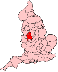
Staffordshire (![]() /ˈstæfərdʃaɪər/,
/ˈstæfərdʃaɪər/, ![]() /ˈstæfərdʃər/ or /ˈstæfərdʃɪər/; abbreviated Staffs) is a landlocked county in the West Midlands region of England. Part of the National Forest lies within its borders. It adjoins the ceremonial counties of Cheshire, Derbyshire, Leicestershire, Warwickshire, West Midlands, Worcestershire, and Shropshire.
/ˈstæfərdʃər/ or /ˈstæfərdʃɪər/; abbreviated Staffs) is a landlocked county in the West Midlands region of England. Part of the National Forest lies within its borders. It adjoins the ceremonial counties of Cheshire, Derbyshire, Leicestershire, Warwickshire, West Midlands, Worcestershire, and Shropshire.
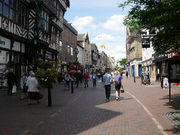
The largest city in Staffordshire is Stoke-on-Trent, which is administered separately from the rest of the county as an independent unitary authority. Lichfield also has city status, although this is a considerably smaller cathedral city. Major towns include Stafford (the county town), Burton upon Trent, Cannock, Newcastle-under-Lyme and Tamworth. Wolverhampton and Walsall were also in Staffordshire until local government reorganisation in 1974, but are now within the West Midlands county.
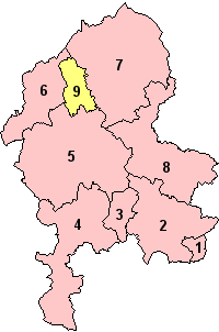
Apart from Stoke-on-Trent, Staffordshire is divided into the districts of Cannock Chase, East Staffordshire, Lichfield, Newcastle-under-Lyme, South Staffordshire, Stafford, Staffordshire Moorlands, and Tamworth.
Contents |
History
Historically, Staffordshire was divided into the five hundreds of Cuttlestone, Offlow, Pirehill, Seisdon, and Totmonslow.
The historic boundaries of Staffordshire cover much of what is now the metropolitan county of West Midlands. An administrative county of Staffordshire was set up in 1889 under the Local Government Act 1888 covering the county except the county boroughs of Wolverhampton, Walsall, and West Bromwich in the south (the area known as the Black Country), and Hanley in the north. The Act also saw the towns of Tamworth (partly in Warwickshire) and Burton upon Trent (partly in Derbyshire) united entirely in Staffordshire.
In 1553 Queen Mary made Lichfield a county separate from the rest of Staffordshire. It remained so until 1888.
Handsworth and Perry Barr became part of the county borough of Birmingham in the early 20th century, and thus associated with Warwickshire. Burton, in the east of the county, became a county borough in 1901, and was followed by Smethwick, another Black Country town in 1907. In 1910 the six towns of the Staffordshire Potteries, including Hanley, became the single county borough of Stoke-on-Trent.
A major reorganisation in the Black Country in 1966, under the recommendation of the Local Government Commission for England led to the creation of an area of contiguous county boroughs. The County Borough of Warley was formed by the merger of the county borough of Smethwick and municipal borough of Rowley Regis with the Worcestershire borough of Oldbury: the resulting county borough was associated with Worcestershire. Meanwhile, the county borough of Dudley, historically a detached part of Worcestershire, expanded and became associated with Staffordshire instead. This reorganisation led to the administrative county of Staffordshire having a thin protusion passing between the county boroughs (to the east) and Shropshire, to the west, to form a short border with Worcestershire.
Under the Local Government Act 1972, on April 1, 1974 the county boroughs of the Black Country and the Aldridge-Brownhills Urban District of Staffordshire became, along with Birmingham, Solihull, and Coventry and other districts, a new metropolitan county of West Midlands. County boroughs were abolished, with Stoke becoming a non-metropolitan district in Staffordshire, and Burton forming an unparished area in the district of East Staffordshire. On April 1, 1997, under a recommendation of the Banham Commission, Stoke-on-Trent became a unitary authority independent of Staffordshire once more.
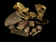
In July 2009, the largest hoard of Anglo-Saxon gold ever found in Britain was discovered in a field near Lichfield. The artefacts, known as The Staffordshire Hoard have tentatively been dated to the 7th or 8th centuries, placing the origin of the items in the time of the Kingdom of Mercia.
Economy
This is a chart of trend of regional gross value added of the non-metropolitan county of Staffordshire at current basic prices published (pp. 240–253) by Office for National Statistics with figures in millions of British Pounds Sterling.
| Year | Regional Gross Value Added[1] | Agriculture[2] | Industry[3] | Services[4] |
|---|---|---|---|---|
| 1995 | 6,447 | 209 | 2,349 | 3,889 |
| 2000 | 8,621 | 150 | 2,986 | 5,485 |
| 2003 | 10,169 | 169 | 3,164 | 6,835 |
- ↑ Components may not sum to totals due to rounding
- ↑ includes hunting and forestry
- ↑ includes energy and construction
- ↑ includes financial intermediation services indirectly measured
Some National and Internationally known Companies have their base in Staffordshire.They include The Britannia Building Society which is based in Leek. JCB are based in Rocester near Uttoxeter.The Theme park Alton Towers is in the Staffordshire Moorlands and several of the worlds largest Pottery Manufacturers are based in Stoke On Trent.
Education
Staffordshire has a completely comprehensive system with eight independent schools. Most secondary schools are from 11–16 or 18, but two in Staffordshire Moorlands and South Staffordshire are from 13–18. Resources are shared where appropriate, as per the example of Kingsmead Technology College, Blake High School and Norton Canes High School combining their sixth forms to create a "Sixth Form Consortium", which can offer a greater selection of subjects than each school could individually.
Two universities are located in the county. Keele University is located in Newcastle-under-Lyme. Staffordshire University has two campuses; one located in Stoke-on-Trent, the other in Stafford.
Geography
In the north and in the south the county is hilly, with wild moorlands in the far north and Cannock Chase an area of natural beauty in the south. In the middle regions the landscape is low and undulating. Throughout the entire county there are vast and important coalfields. In the southern part there are also rich iron ore deposits. The largest river is the Trent. The soil is chiefly clay and agriculture was not highly developed until the mechanisation of farms.
Staffordshire is home to the highest village in Britain, Flash. The village in the Staffordshire Moorlands stands at 463 m (1518 ft) above sea level. This record was confirmed in 2007 by the Ordnance Survey after Wanlockhead in Scotland also claimed the record. The BBC's The One Show investigated the case in a bid to settle the argument and Flash was confirmed as the highest.
Government
Staffordshire County Council is the top-tier local authority for the non-metropolitan county.
Staffordshire operates a cabinet-style council. There are 62 councillors for Staffordshire. The Full Council elects a cabinet of 10 councillors, including the council leader, from the majority party. Each cabinet member has their own portfolio about which they make the "day to day" decisions. [1][2]
Latest Council Election results
| Staffordshire County Council election, 2009 | ||||||||||
|---|---|---|---|---|---|---|---|---|---|---|
| Party | Seats | Gains | Losses | Net Gain/Loss | Seats % | Votes % | Votes | +/- | ||
| Labour | 3 | -29 | 46315 | |||||||
| Conservative | 49 | +22 | 109699 | |||||||
| Liberal Democrat | 4 | +2 | ||||||||
| UKIP | 4 | +4 | ||||||||
Boundary changes
Towns and villages
See the list of places in Staffordshire and the List of civil parishes in Staffordshire
Dogs
A type of bull terrier called the Staffordshire Bull Terrier was bred for hunting purposes in this county. They are known affectionately as "Staffs", "Staffies", and "Nanny-dogs". Staffies should not be confused with the considerably larger American Staffordshire Terrier, American Pit Bull Terrier, and (English) Bull Terrier.
Transport
Canals
Staffordshire has an extensive network of canals including the Birmingham and Fazeley Canal, Caldon Canal, Coventry Canal, Shropshire Union Canal, Staffordshire and Worcestershire Canal and Trent and Mersey Canal.
Railways
See Rail transport in Staffordshire
Roads
The county has relatively good links to the national roads network. Several major roads intersect the county, making it a popular location for commuters working in Birmingham.
The M42 has a junction in Tamworth at the south-east of the county, and heads south-west towards Birmingham. The M6 runs north through the county and junctions 10A-16 are in the county. The M6 Toll, the UK's first toll motorway, runs through the county with junctions in Weeford near Lichfield, Cannock and joins the M6 heading north towards Stafford.
The A5 and A34 run through the county. The former has been significantly widened to a dual carriageway at several sections, although much of it remains single carriageway.
Mermaid's Pool
Mermaid's Pool is a legend linked to a pool located in the mountainous ridges of The Roaches in Staffordshire, England. According to legend, it is said to share something of a mysterious link with the Atlantic ocean, yet be poisonous to animals and fish. Legend has it, too, that the mermaid appears but once a year on Easter Eve at midnight, and anyone who sees her is either given the gift of immortality, or drawn into the depths of the pool to face their doom.
Places of interest
|
|
|
||||||||||||||||||||||||||
Gallery
.jpg) Map of Staffordshire and its hundreds by Wenceslas Hollar some time between 1627-1677. |
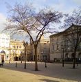 Stafford Shire Hall . |
 Tamworth Castle. |
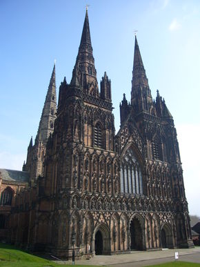
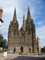 Lichfield Cathedral. |
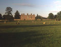 Weston Park |
 Wightwick Manor |
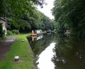 The Staffordshire & Worcestershire Canal. |
See also
- Samuel Hieronymus Grimm
- The Stafford knot
- Tamworth Pig
References
- ↑ "Role of County Council". Staffordshire County Council. http://www.staffordshire.gov.uk/yourcouncil/decisionmakingcouncil/roleofcountycouncil/. Retrieved 2010-May-05.
- ↑ "Role of the Cabinet". Staffordshire County Council. http://www.staffordshire.gov.uk/yourcouncil/decisionmakingcouncil/roleofthecabinet/. Retrieved 2010-May-05.
External links
- Staffordshire at the Open Directory Project
- East Staffordshire Community Website
- BBC Staffordshire website
- Staffordshire County Council
- Staffordshire Past Track - Historical archive about the county
- The story of a Staffordshire Home Guard Battalion, 1940-1944
- Staffordshire Photographs
- Staffordshire Tourism website
- The Staffordshire Encyclopaedia
- Staffordshire Business Directory
- Staffordshire Governors Association
|
||||||||||||||||||||
|
||||||||
|
|||||