Macapá
| Macapá | |||
|---|---|---|---|
| — Municipality — | |||
| The Municipality of Macapá | |||
 |
|||
|
|||
| Nickname(s): "A Capital do Meio do Mundo" ("The Capital of the Middle of the World") | |||
 |
|||
 |
|||
| Coordinates: | |||
| Country | |||
| Region | North | ||
| State | |||
| Founded | February 9, 1758 | ||
| Government | |||
| - Mayor | Roberto Goés (PDT) | ||
| Area | |||
| - Total | 6.563 km2 (2.5 sq mi) | ||
| Population (2006) | |||
| - Total | 368,397 | ||
| - Density | 56.1/km2 (145.3/sq mi) | ||
| Time zone | UTC-3 | ||
| Postal Code | 68900-000 | ||
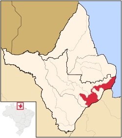
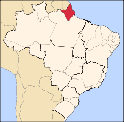
Macapá (Tupi-Guarani: "Good Thing"[1] or "Maïtc Pia", Portuguese pronunciation: [makaˈpa]) is the capital of the state of Amapá in Brazil, on the Amazon River. With a population of 366,484 people in 2009, mining is central to its economy. It exports tin iron, gold, and manganese, as well as lumber, oil, animal pelts, and fish. Manufactures include rubber products and food. Founded in 1688 by military men in the vicinity of a fortress protecting access to the mouth of the Amazon, Macapá grew very slowly until it became the capital of Amapá, which was created (as a federal territory) in 1943. The old fortress is now a regional museum.
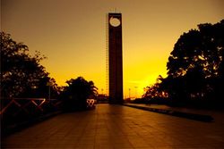
The city lies exactly on the Equator, at 0° N, and hosts a monument to this, known as Marco Zero ("Zero Mark"). Next to it there are both a sambadrome and a football stadium (the Zerão), proud to be the only one in the world where each half of the field is located in opposite hemispheres.
Contents |
History
Macapá is a corruption of the Tupi word macapaba, or place of many bacabas. A bacaba is the fruit of the local palm. The Spanish called it Adelantado de Nueva Andalucía when it was claimed for Spain by Francisco de Orellana in 1544.[2] In 1738 a Portuguese military detachment was stationed in Macapá, and on 4 February 1758 Sebastião Veiga Cabral, the illegitimate child of the military governor of Trás-os-Montes, Sebastião Veiga Cabral, founded the town of São José de Macapá, under the authority of the governor of Pará, Francisco Xavier de Mendonça Furtado.
The fortress of São José de Macapá was first laid out in 1764, but it took 18 years to complete, due to illness among the Indian workers, and flight among the Black workers.[2].
Macapá gained international notoriety in December 2001 when the International NZ yachtsman Peter Blake was murdered while anchored on his explorer yacht Seamaster off the Port of Macapa.
Geography
Macapá is located 345 km from Belém, but is accessible only by boat or airplane. There are no through roads [2] to "mainland Brazil", although it is possible to drive to Georgetown, Guyana.
Climate
Macapá has an equatorial climate; a type of tropical climate in which there is no dry season – all months have mean precipitation values of at least 60mm. It is usually found at latitudes within five degrees of the equator – which are dominated by the Intertropical Convergence Zone.
Vegetation
Macapá has a Tropical forest. Rainforests are characterized by high rainfall, with definitions setting minimum normal annual rainfall between 2,000 mm (about 78 inches or 2 meters) and 1700 mm (about 67 inches). The soil can be poor because high rainfall tends to leach out soluble nutrients. There are several common characteristics of tropical rainforest trees. Tropical rainforest species frequently possess one or more of the following attributes not commonly seen in trees of higher latitudes or trees in drier conditions on the same latitude.
Economy
The GDP for the city was R$ 2,826,458,000 (2005).[3]
The per capita income for the city was R$ 7,950 (2005).[4]
Education
Portuguese is the official national language, and thus the primary language taught in schools. But English and French (due to the proximity with French Guiana) are part of the official high school curriculum.
Educational institutions
- Universidade Federal do Amapá (Unifap);
- Universidade Estadual do Amapá (UEAP);
- Faculdade de Macapá (Fama);
- and many others.
Transportation
International airport
The city is served by the Macapá International Airport.
Highways
The city is connected with the rest of the country through the following highways: AP-010, linking the capital to the city of Santana, southwest of Macapá; AP-030, linking Macapá to the city of Mazagão and BR-156, linking Macapá to the south of Amapá and to Pará, more specifically to the city of Laranjal do Jari, and to the north to the city of Oiapoque.
Notes
- ↑ [1]
- ↑ 2.0 2.1 2.2 História de Macapá in Portuguese
- ↑ (in Portuguese) (PDF) GDP. Macapá, Brazil: IBGE. 2005. ISBN 85-240-3919-1. http://www.ibge.gov.br/home/estatistica/economia/pibmunicipios/2005/tab01.pdf. Retrieved 2007-07-18.
- ↑ (in Portuguese) (PDF) per capita income. Macapá, Brazil: IBGE. 2005. ISBN 85-240-3919-1. http://www.ibge.gov.br/home/estatistica/economia/pibmunicipios/2005/tab01.pdf. Retrieved 2007-07-18.
External links
- Cidade de Macapá in Portuguese
|
|||||||||||||||||||||||||||||||||||||||||||||||||||||||||||||||||||||||||||||||||||||||||||||||||||||||||||||||||||||||